

Aberdeen Township, New Jersey
Encyclopedia
Aberdeen Township is a Township
in Monmouth County
, New Jersey
, United States. As of the 2010 United States Census, the township population was 18,210.
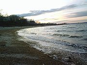
Aberdeen Township is part of the Bayshore Regional Strategic Plan, an effort by nine municipalities in northern Monmouth County to reinvigorate the area's economy by emphasizing the traditional downtowns, dense residential neighborhoods, maritime history, and the natural beauty of the Raritan Bay
coastline.
, the township has a total area of 7.8 square miles (20.2 km²), of which, 5.5 square miles (14.2 km²) of it is land and 2.2 square miles (5.7 km²) of it (28.61%) is water.
Cliffwood Beach
(2000 Census population of 3,538) and Strathmore
(6,740) are census-designated place
s and unincorporated areas located within Aberdeen Township
of 2000, there were 17,454 people, 6,421 households, and 4,770 families residing in the township. The population density
was 3,152.2 people per square mile (1,216.4/km²). There were 6,558 housing units at an average density of 1,184.4 per square mile (457.1/km²). The racial makeup of the township was 78.82% White
, 12.02% African American, 0.14% Native American
, 5.51% Asian, 0.01% Pacific Islander, 1.75% from other races
, and 1.75% from two or more races. Hispanic or Latino of any race were 7.02% of the population.
There were 6,421 households out of which 34.4% had children under the age of 18 living with them, 60.2% were married couples
living together, 10.5% had a female householder with no husband present, and 25.7% were non-families. 20.2% of all households were made up of individuals and 5.0% had someone living alone who was 65 years of age or older. The average household size was 2.70 and the average family size was 3.14.
In the township the population was spread out with 24.5% under the age of 18, 6.2% from 18 to 24, 35.0% from 25 to 44, 24.0% from 45 to 64, and 10.4% who were 65 years of age or older. The median age was 37 years. For every 100 females there were 95.1 males. For every 100 females age 18 and over, there were 92.4 males.
The median income for a household in the township was $68,125, and the median income for a family was $76,648. Males had a median income of $51,649 versus $35,707 for females. The per capita income
for the township was $28,984. About 3.8% of families and 4.7% of the population were below the poverty line, including 7.1% of those under age 18 and 4.6% of those age 65 or over.
form of government, in force since 1857, to the Council-Manager
form, under the Faulkner Act
. In this Council-Manager form, all policy making power is concentrated in the council. The Mayor is a member of the Council and presides over its meetings. The Manager, appointed by the council and fully accountable to it, is the municipal chief executive and administrative official. Aberdeen Township is one of over 40 municipalities in New Jersey with this form of government.
A seven-member Township Council is elected at large for staggered, four-year terms of office in partisan elections held in November. The council selects a mayor and deputy mayor from among its members.
, members of the Aberdeen Township Council are Mayor
Fred Tagliarini, Deputy Mayor
Vincent Vinci, Greg Cannon, Owen Drapkin, Wilhelmina Gumbs and James Lauro and Margaret Montone.
, together with the neighboring community of Matawan
. Schools in the district (with 2005-06 enrollment data from the National Center for Education Statistics
) are
Cambridge Park Developmental Learning Center (Preschool; 55 students),
Cliffwood Elementary School (Grades K-3; 431 students),
Ravine Drive Elementary School (Grades K-3; 351 students),
Strathmore Elementary School (Grades K-3; 472 students),
Lloyd Road Elementary School (Grades 4-5; 603 students),
Matawan Aberdeen Middle School (Grades 6 - 8; 926 students) and
Matawan Regional High School
(Grades 9 - 12; 1,052 students). The MARSD Central Offices are located at 1 Crest Way, in Aberdeen.
. About the year 1000, an agricultural society developed, and small villages dotted what was to become New Jersey. The Lenape began a westward retreat in the face of European settlement and disease beginning in the late seventeenth century, beginning in Monmouth County by the mid-eighteenth century. Although the Lenape presently live in Ontario
and Oklahoma
, their legacy survives in such names as Mohingson, Luppatatong and Matawan Creeks and Raritan Bay.
 The earliest known attempt at European settlement was in 1650 when the south side of Raritan Bay
was purchased from the Lenni Lenape by the New Netherland
Colony. The Dutch failed to make any permanent settlements of this area.
granted 36 acres (146,000 m²) to Jonathan Holmes. This is in present-day Oakshades on Mohingson Creek
.
Aberdeen Township derived its name from "New Aberdeen," a name for a settlement established in Northwestern Monmouth County in the 1680s by Quakers
and Presbyterians who fled Scotland
to avoid religious persecution.
In 1684, Surveyor General Thomas Rudyard
received a grant of 1038 acres (4.2 km²) on Raritan Bay
and Matawan Creek
, the present location of Cliffwood and Cliffwood Beach. Owing to Rudyard's high office, this was quite controversial, and in 1685, the Board of Proprietors issued an order regarding the laying out of land. Section 7 addressed questionable activity such as Rudyard's, and he sold his land to his son-in-law, Samuel Winder.
The 1680s saw an influx of Scottish immigrants fleeing religious persecution in response to a 1683 book by George Scott extolling the virtues of Scottish settlement in East Jersey
. In 1701, a village site of 100 acres (405,000 m²) was granted by the Proprietors to 24 Scottish settlers of the area. These men and six others also purchased a landing site on Matawan Creek.
The village site eventually came to be called Mount Pleasant, and the landing, as it became an important shipping point for the produce of Middletown Township
, became Middletown Point. A third, very scattered settlement developed in the eighteenth century west of Matawan Creek, and was called Matawan or Matavan.
, Hazlet Township, Middletown (including Sandy Hook
), Matawan Borough
, Keyport
, Union Beach
, Keansburg
, Atlantic Highlands
, Highlands
and a sliver of Colts Neck Township
. It originally extended as far northwest as Cheesequake Creek, that portion being ceded to Middlesex County in 1710.
).
and Senate
, was signed by Governor of New Jersey
William A. Newell
, and on February 23, 1857, Matavan Township was incorporated from portions of what was then Raritan Township. This included the village of Middletown Point, Mt. Pleasant, and Matavan. The Township was named for the creek as well as the village of Matavan. The spelling of "Matawan" or "Matavan" had been interchangeable, however, when the act was published "Matavan", a Lenape word meaning "where two rivers come together" had been used.
In 1865, due to postal confusion with Middletown, the Middletown Point post office
was renamed "Matawan", to reflect the name of the Township. This section is the present downtown area of Matawan Borough. In 1882, the spelling of the Township was officially changed to "Matawan".
When the railroads were built in the 1870s several stations were established. As the station at Main Street was to be "Matawan", the one at Cliffwood Avenue had to be something else, although the old name "Matavan" was still applied to that area. To avoid near duplication, "Hutschler's Crossing" was briefly used; the railroad then changed the station name to "Cliffwood", after the coastal area of the Township.
, the "Poet of Revolution," and a former Mount Pleasant resident who is buried in the area. This post office has since been closed.
was formed as a borough on June 28, 1895, from portions of Matawan Township, based on the results of a referendum held that day. Matawan expanded with portions of Matawan Township in 1931 and 1933.
when year-round homes were the norm. River Gardens developed in the late 1940s, and the 1960s brought Strathmore, which more than doubles the Township's population and transformed a farming community into a bustling suburb.
Today, Aberdeen is a suburban Township of 5.4 square miles (14 km²) containing a mix of residence, light industry and shopping centers. Sections of the Township include Cliffwood, Cliffwood Beach, Freneau, Oakshades, River Gardens, Strathmore and Woodfield. The population is approximately 17,000 and there are three postal ZIP codes which service the Township: 07721, 07735 and 07747.
The Township is served by two volunteer fire companies, the Aberdeen Township Hose and Chemical Co. No. 1, organized in 1918, and the Cliffwood Volunteer Fire Co., organized in 1927. Two volunteer First Aid Squads response to the community's emergency medical needs; the Aberdeen Township First Aid and Rescue Squad, organized in 1954, and the South Aberdeen Emergency Medical Service, organized in 1970. A Full time Police Department was established in 1935.
The Henry Hudson Trail
is a 9 miles (14.5 km) paved trail built on a former Central Railroad of New Jersey
right-of-way and extending from Aberdeen Township east to Atlantic Highlands
.
Township (New Jersey)
A township, in the context of New Jersey local government, refers to one of five types and one of eleven forms of municipal government. As a political entity, a township is a full-fledged municipality, on par with any town, city, borough, or village, collecting property taxes and providing...
in Monmouth County
Monmouth County, New Jersey
Monmouth County is a county located in the U.S. state of New Jersey, within the New York metropolitan area. As of the 2010 Census, the population was 630,380, up from 615,301 at the 2000 census. Its county seat is Freehold Borough. The most populous municipality is Middletown Township with...
, New Jersey
New Jersey
New Jersey is a state in the Northeastern and Middle Atlantic regions of the United States. , its population was 8,791,894. It is bordered on the north and east by the state of New York, on the southeast and south by the Atlantic Ocean, on the west by Pennsylvania and on the southwest by Delaware...
, United States. As of the 2010 United States Census, the township population was 18,210.
Aberdeen Township is part of the Bayshore Regional Strategic Plan, an effort by nine municipalities in northern Monmouth County to reinvigorate the area's economy by emphasizing the traditional downtowns, dense residential neighborhoods, maritime history, and the natural beauty of the Raritan Bay
Raritan Bay
Raritan Bay is a bay located at the southern portion of Lower New York Bay between the U.S. states of New York and New Jersey and is part of the New York Bight. The bay is bounded on the northwest by New York's Staten Island, on the west by Perth Amboy, New Jersey, on the south by the Raritan...
coastline.
Geography
According to the United States Census BureauUnited States Census Bureau
The United States Census Bureau is the government agency that is responsible for the United States Census. It also gathers other national demographic and economic data...
, the township has a total area of 7.8 square miles (20.2 km²), of which, 5.5 square miles (14.2 km²) of it is land and 2.2 square miles (5.7 km²) of it (28.61%) is water.
Cliffwood Beach
Cliffwood Beach, New Jersey
Cliffwood Beach is a census-designated place in Monmouth County, New Jersey, United States. The population was 3,194 as of the 2010 census.-Geography:...
(2000 Census population of 3,538) and Strathmore
Strathmore, New Jersey
Strathmore is a census-designated place in Aberdeen Township, Monmouth County, New Jersey, United States. The population was 7,258 at the 2010 census.-Geography:Strathmore is located at ....
(6,740) are census-designated place
Census-designated place
A census-designated place is a concentration of population identified by the United States Census Bureau for statistical purposes. CDPs are delineated for each decennial census as the statistical counterparts of incorporated places such as cities, towns and villages...
s and unincorporated areas located within Aberdeen Township
Demographics
As of the censusCensus
A census is the procedure of systematically acquiring and recording information about the members of a given population. It is a regularly occurring and official count of a particular population. The term is used mostly in connection with national population and housing censuses; other common...
of 2000, there were 17,454 people, 6,421 households, and 4,770 families residing in the township. The population density
Population density
Population density is a measurement of population per unit area or unit volume. It is frequently applied to living organisms, and particularly to humans...
was 3,152.2 people per square mile (1,216.4/km²). There were 6,558 housing units at an average density of 1,184.4 per square mile (457.1/km²). The racial makeup of the township was 78.82% White
White American
White Americans are people of the United States who are considered or consider themselves White. The United States Census Bureau defines White people as those "having origins in any of the original peoples of Europe, the Middle East, or North Africa...
, 12.02% African American, 0.14% Native American
Native Americans in the United States
Native Americans in the United States are the indigenous peoples in North America within the boundaries of the present-day continental United States, parts of Alaska, and the island state of Hawaii. They are composed of numerous, distinct tribes, states, and ethnic groups, many of which survive as...
, 5.51% Asian, 0.01% Pacific Islander, 1.75% from other races
Race (United States Census)
Race and ethnicity in the United States Census, as defined by the Federal Office of Management and Budget and the United States Census Bureau, are self-identification data items in which residents choose the race or races with which they most closely identify, and indicate whether or not they are...
, and 1.75% from two or more races. Hispanic or Latino of any race were 7.02% of the population.
There were 6,421 households out of which 34.4% had children under the age of 18 living with them, 60.2% were married couples
Marriage
Marriage is a social union or legal contract between people that creates kinship. It is an institution in which interpersonal relationships, usually intimate and sexual, are acknowledged in a variety of ways, depending on the culture or subculture in which it is found...
living together, 10.5% had a female householder with no husband present, and 25.7% were non-families. 20.2% of all households were made up of individuals and 5.0% had someone living alone who was 65 years of age or older. The average household size was 2.70 and the average family size was 3.14.
In the township the population was spread out with 24.5% under the age of 18, 6.2% from 18 to 24, 35.0% from 25 to 44, 24.0% from 45 to 64, and 10.4% who were 65 years of age or older. The median age was 37 years. For every 100 females there were 95.1 males. For every 100 females age 18 and over, there were 92.4 males.
The median income for a household in the township was $68,125, and the median income for a family was $76,648. Males had a median income of $51,649 versus $35,707 for females. The per capita income
Per capita income
Per capita income or income per person is a measure of mean income within an economic aggregate, such as a country or city. It is calculated by taking a measure of all sources of income in the aggregate and dividing it by the total population...
for the township was $28,984. About 3.8% of families and 4.7% of the population were below the poverty line, including 7.1% of those under age 18 and 4.6% of those age 65 or over.
Local government
On November 3, 1964, the citizens of Aberdeen Township voted to change from the Township CommitteeTownship (New Jersey)
A township, in the context of New Jersey local government, refers to one of five types and one of eleven forms of municipal government. As a political entity, a township is a full-fledged municipality, on par with any town, city, borough, or village, collecting property taxes and providing...
form of government, in force since 1857, to the Council-Manager
Faulkner Act (Council-Manager)
The Faulkner Act, or Optional Municipal Charter Law, provides for New Jersey municipalities to adopt a Council-Manager government.The council consists of 5, 7, or 9 members elected by the public...
form, under the Faulkner Act
Faulkner Act (New Jersey)
The Optional Municipal Charter Law or Faulkner Act provides New Jersey municipalities with a variety of models of local government. This legislation is called the Faulkner Act in honor of the late Bayard H...
. In this Council-Manager form, all policy making power is concentrated in the council. The Mayor is a member of the Council and presides over its meetings. The Manager, appointed by the council and fully accountable to it, is the municipal chief executive and administrative official. Aberdeen Township is one of over 40 municipalities in New Jersey with this form of government.
A seven-member Township Council is elected at large for staggered, four-year terms of office in partisan elections held in November. The council selects a mayor and deputy mayor from among its members.
, members of the Aberdeen Township Council are Mayor
Mayor
In many countries, a Mayor is the highest ranking officer in the municipal government of a town or a large urban city....
Fred Tagliarini, Deputy Mayor
Deputy Mayor
Deputy mayor is an elective or appointive office of the second-ranking official in many local governments. Many elected deputy mayors are members of the city council who are given the title and serve as acting mayor in the mayor's absence...
Vincent Vinci, Greg Cannon, Owen Drapkin, Wilhelmina Gumbs and James Lauro and Margaret Montone.
Federal, state and county representation
Aberdeen Township is in the 6th Congressional district and is part of New Jersey's 13th state legislative district. The legislative district was unchanged based on the results of the 2010 Census.Education
Aberdeen is part of the Matawan-Aberdeen Regional School DistrictMatawan-Aberdeen Regional School District
The Matawan-Aberdeen Regional School District is a regional school district in Monmouth County, New Jersey. The district serves students in grades K - 12 from the communities of Aberdeen Township and the neighboring community of Matawan Borough .As of the 2007-08 school year, the district's seven...
, together with the neighboring community of Matawan
Matawan, New Jersey
Matawan is a borough in Monmouth County, New Jersey, United States. As of the 2010 United States Census, the borough population was 8,810. The name "Matawan" comes from a Native American Lenape word....
. Schools in the district (with 2005-06 enrollment data from the National Center for Education Statistics
National Center for Education Statistics
The National Center for Education Statistics is the part of the United States Department of Education's Institute of Education Sciences that collects, analyzes, and publishes statistics on education and public school district finance information in the United States...
) are
Cambridge Park Developmental Learning Center (Preschool; 55 students),
Cliffwood Elementary School (Grades K-3; 431 students),
Ravine Drive Elementary School (Grades K-3; 351 students),
Strathmore Elementary School (Grades K-3; 472 students),
Lloyd Road Elementary School (Grades 4-5; 603 students),
Matawan Aberdeen Middle School (Grades 6 - 8; 926 students) and
Matawan Regional High School
Matawan Regional High School
Matawan Regional High School is a four-year regional public high school located in Aberdeen Township, New Jersey, United States. The school is part of the Matawan-Aberdeen Regional School District and it is one of Monmouth County's largest schools. It has been accredited by the Middle States...
(Grades 9 - 12; 1,052 students). The MARSD Central Offices are located at 1 Crest Way, in Aberdeen.
Origins
Those who settled in this area developed into the Lenni Lenape Native AmericansNative Americans in the United States
Native Americans in the United States are the indigenous peoples in North America within the boundaries of the present-day continental United States, parts of Alaska, and the island state of Hawaii. They are composed of numerous, distinct tribes, states, and ethnic groups, many of which survive as...
. About the year 1000, an agricultural society developed, and small villages dotted what was to become New Jersey. The Lenape began a westward retreat in the face of European settlement and disease beginning in the late seventeenth century, beginning in Monmouth County by the mid-eighteenth century. Although the Lenape presently live in Ontario
Ontario
Ontario is a province of Canada, located in east-central Canada. It is Canada's most populous province and second largest in total area. It is home to the nation's most populous city, Toronto, and the nation's capital, Ottawa....
and Oklahoma
Oklahoma
Oklahoma is a state located in the South Central region of the United States of America. With an estimated 3,751,351 residents as of the 2010 census and a land area of 68,667 square miles , Oklahoma is the 28th most populous and 20th-largest state...
, their legacy survives in such names as Mohingson, Luppatatong and Matawan Creeks and Raritan Bay.
Raritan Bay
Raritan Bay is a bay located at the southern portion of Lower New York Bay between the U.S. states of New York and New Jersey and is part of the New York Bight. The bay is bounded on the northwest by New York's Staten Island, on the west by Perth Amboy, New Jersey, on the south by the Raritan...
was purchased from the Lenni Lenape by the New Netherland
New Netherland
New Netherland, or Nieuw-Nederland in Dutch, was the 17th-century colonial province of the Republic of the Seven United Netherlands on the East Coast of North America. The claimed territories were the lands from the Delmarva Peninsula to extreme southwestern Cape Cod...
Colony. The Dutch failed to make any permanent settlements of this area.
New Jersey
The earliest English land grant in Aberdeen was in 1677 when Sir George CarteretGeorge Carteret
Vice Admiral Sir George Carteret, 1st Baronet , son of Elias de Carteret, was a royalist statesman in Jersey and England, who served in the Clarendon Ministry as Treasurer of the Navy...
granted 36 acres (146,000 m²) to Jonathan Holmes. This is in present-day Oakshades on Mohingson Creek
Mohingson Creek
Mohingson Creek is a stream located in Monmouth County, New Jersey. Its source is in the Mount Pleasant Hills; it flows north through Holmdel and Aberdeen Townships into Matawan Creek. The name is sometimes shortened to Whingson or Winkson....
.
Aberdeen Township derived its name from "New Aberdeen," a name for a settlement established in Northwestern Monmouth County in the 1680s by Quakers
Religious Society of Friends
The Religious Society of Friends, or Friends Church, is a Christian movement which stresses the doctrine of the priesthood of all believers. Members are known as Friends, or popularly as Quakers. It is made of independent organisations, which have split from one another due to doctrinal differences...
and Presbyterians who fled Scotland
Scotland
Scotland is a country that is part of the United Kingdom. Occupying the northern third of the island of Great Britain, it shares a border with England to the south and is bounded by the North Sea to the east, the Atlantic Ocean to the north and west, and the North Channel and Irish Sea to the...
to avoid religious persecution.
In 1684, Surveyor General Thomas Rudyard
Thomas Rudyard
Thomas Rudyard was a deputy of East Jersey.Born at Abbey Farm, Leek, Staffordshire, he was one of many proprietors of New Jersey, owning half of a share of West Jersey property.-Sources:* -See also:...
received a grant of 1038 acres (4.2 km²) on Raritan Bay
Raritan Bay
Raritan Bay is a bay located at the southern portion of Lower New York Bay between the U.S. states of New York and New Jersey and is part of the New York Bight. The bay is bounded on the northwest by New York's Staten Island, on the west by Perth Amboy, New Jersey, on the south by the Raritan...
and Matawan Creek
Matawan Creek
Matawan Creek is a creek and partially a tidal estuary of the Atlantic Ocean. It lies in the east central sector of New Jersey across from Staten Island, New York....
, the present location of Cliffwood and Cliffwood Beach. Owing to Rudyard's high office, this was quite controversial, and in 1685, the Board of Proprietors issued an order regarding the laying out of land. Section 7 addressed questionable activity such as Rudyard's, and he sold his land to his son-in-law, Samuel Winder.
The 1680s saw an influx of Scottish immigrants fleeing religious persecution in response to a 1683 book by George Scott extolling the virtues of Scottish settlement in East Jersey
East Jersey
The Province of East Jersey and the Province of West Jersey were two distinct, separately governed parts of the Province of New Jersey that existed as separate provinces for 28 years, between 1674 and 1702. East Jersey's capital was located at Perth Amboy...
. In 1701, a village site of 100 acres (405,000 m²) was granted by the Proprietors to 24 Scottish settlers of the area. These men and six others also purchased a landing site on Matawan Creek.
The village site eventually came to be called Mount Pleasant, and the landing, as it became an important shipping point for the produce of Middletown Township
Middletown Township, New Jersey
Middletown Township is a township in Monmouth County, New Jersey, United States. As of the 2010 United States Census, the township had a total population of 66,522...
, became Middletown Point. A third, very scattered settlement developed in the eighteenth century west of Matawan Creek, and was called Matawan or Matavan.
Middletown Township
Since 1693, what was to become Aberdeen Township remained part of Middletown Township which, at the time, consisted of what is now Aberdeen, Holmdel TownshipHolmdel Township, New Jersey
Holmdel Township is a township in Monmouth County, New Jersey, United States. As of the 2010 United States Census, the township population was 16,773. Holmdel Township was formed by an Act of the New Jersey Legislature on February 23, 1857, from portions of Raritan Township .Holmdel is a suburb of...
, Hazlet Township, Middletown (including Sandy Hook
Sandy Hook, New Jersey
Sandy Hook is a barrier spit, approximately 6.0 miles in length and varying between 0.10 and 1 miles wide in Middletown Township in Monmouth County, along the Atlantic Ocean coast of eastern New Jersey in the United States. The barrier spit encloses the southern entrance of Lower New York Bay...
), Matawan Borough
Matawan, New Jersey
Matawan is a borough in Monmouth County, New Jersey, United States. As of the 2010 United States Census, the borough population was 8,810. The name "Matawan" comes from a Native American Lenape word....
, Keyport
Keyport, New Jersey
Keyport is a borough in Monmouth County, New Jersey, United States. As of the 2010 United States Census, the borough population was 7,240. Keyport's nickname is the "Pearl of the Bayshore" or the "Gateway to the Bayshore"....
, Union Beach
Union Beach, New Jersey
Union Beach is a borough in Monmouth County, New Jersey, United States. As of the 2010 United States Census, the borough population was 6,245....
, Keansburg
Keansburg, New Jersey
Keansburg is a borough in Monmouth County, New Jersey, United States. As of the 2010 United States Census, the borough population was 10,105.Keansburg was formed as a borough by an act of the New Jersey Legislature on March 26, 1917, from portions of both Middletown Township and Raritan Township ,...
, Atlantic Highlands
Atlantic Highlands, New Jersey
Atlantic Highlands is a Borough in Monmouth County, New Jersey in the Bayshore Region. As of the 2010 United States Census, the borough population was 4,385...
, Highlands
Highlands, New Jersey
Highlands is a borough in Monmouth County, New Jersey, United States. As of the 2010 United States Census, the borough population was 5,005. It is the home town of film maker, director, and comic book writer Kevin Smith. The eastern part of the town is built on a high bluff that overlooks Sandy...
and a sliver of Colts Neck Township
Colts Neck Township, New Jersey
Colts Neck is a township in Monmouth County, New Jersey, United States. As of the 2010 United States Census, the population was 10,142.What is now Colts Neck Township was established by an act of the New Jersey Legislature as Atlantic Township on February 18, 1847, from portions of Freehold...
. It originally extended as far northwest as Cheesequake Creek, that portion being ceded to Middlesex County in 1710.
Raritan Township
By 1848, Middletown was considered too large and unwieldy, and legislation was passed dividing it into two halves, the western half to be a new municipality, Raritan Township (now Hazlet TownshipHazlet, New Jersey
Hazlet Township is a township in Monmouth County, New Jersey, United States. As of the 2010 United States Census, the township population was 20,334....
).
Matawan Township
Legislation sponsored by Assemblyman Beers passed the State AssemblyNew Jersey General Assembly
The New Jersey General Assembly is the lower house of the New Jersey Legislature.Since the election of 1967 , the Assembly has consisted of 80 members. Two members are elected from each of New Jersey's 40 legislative districts for a term of two years, each representing districts with average...
and Senate
New Jersey Senate
The New Jersey Senate was established as the upper house of the New Jersey Legislature by the Constitution of 1844, replacing the Legislative Council. From 1844 until 1965 New Jersey's counties elected one Senator, each. Under the 1844 Constitution the term of office was three years. The 1947...
, was signed by Governor of New Jersey
Governor of New Jersey
The Office of the Governor of New Jersey is the executive branch for the U.S. state of New Jersey. The office of Governor is an elected position, for which elected officials serve four year terms. While individual politicians may serve as many terms as they can be elected to, Governors cannot be...
William A. Newell
William A. Newell
William Augustus Newell , was an American physician and politician, who was a three-term member of the United States House of Representatives, served as a Republican as the 18th Governor of New Jersey, and as Governor of the Washington Territory from 1880-1884...
, and on February 23, 1857, Matavan Township was incorporated from portions of what was then Raritan Township. This included the village of Middletown Point, Mt. Pleasant, and Matavan. The Township was named for the creek as well as the village of Matavan. The spelling of "Matawan" or "Matavan" had been interchangeable, however, when the act was published "Matavan", a Lenape word meaning "where two rivers come together" had been used.
In 1865, due to postal confusion with Middletown, the Middletown Point post office
Post office
A post office is a facility forming part of a postal system for the posting, receipt, sorting, handling, transmission or delivery of mail.Post offices offer mail-related services such as post office boxes, postage and packaging supplies...
was renamed "Matawan", to reflect the name of the Township. This section is the present downtown area of Matawan Borough. In 1882, the spelling of the Township was officially changed to "Matawan".
When the railroads were built in the 1870s several stations were established. As the station at Main Street was to be "Matawan", the one at Cliffwood Avenue had to be something else, although the old name "Matavan" was still applied to that area. To avoid near duplication, "Hutschler's Crossing" was briefly used; the railroad then changed the station name to "Cliffwood", after the coastal area of the Township.
Cliffwood Post Office
In 1885, the Cliffwood post office was established and the name of the old Matavan settlement passed into obsolescence. That same year, the former Middletown Point section, which had adopted the name "Matawan", was incorporated by referendum as the Borough of Matawan. Originally a self-governing district within the Township, the Borough gained full municipality status in 1896.Freneau Post Office
In response to demand, a post office was established at Mount Pleasant in 1889. As that name was in use elsewhere, a new name was needed. "Freneau" was chosen, in honor of Philip Morin FreneauPhilip Morin Freneau
Philip Morin Freneau was a notable American poet, nationalist, polemicist, sea captain and newspaper editor sometimes called the "Poet of the American Revolution".-Biography:Freneau was born in New York City, the oldest of the five children of Huguenot wine merchant Pierre...
, the "Poet of Revolution," and a former Mount Pleasant resident who is buried in the area. This post office has since been closed.
Matawan Borough
MatawanMatawan, New Jersey
Matawan is a borough in Monmouth County, New Jersey, United States. As of the 2010 United States Census, the borough population was 8,810. The name "Matawan" comes from a Native American Lenape word....
was formed as a borough on June 28, 1895, from portions of Matawan Township, based on the results of a referendum held that day. Matawan expanded with portions of Matawan Township in 1931 and 1933.
Cliffwood Beach
The twentieth century saw several major developments in the Township. The 1920s gave us Cliffwood Beach, which was originally a resort community until after World War IIWorld War II
World War II, or the Second World War , was a global conflict lasting from 1939 to 1945, involving most of the world's nations—including all of the great powers—eventually forming two opposing military alliances: the Allies and the Axis...
when year-round homes were the norm. River Gardens developed in the late 1940s, and the 1960s brought Strathmore, which more than doubles the Township's population and transformed a farming community into a bustling suburb.
Aberdeen Township
On November 8, 1977, the residents of Matawan Township voted to change the name of the Township to create a community identity separate from that of Matawan Borough. The residents voted to call their community Aberdeen Township. Officials believed the new name would draw attention to the Township, as it is listed first alphabetically among New Jersey's 566 municipalities.Today, Aberdeen is a suburban Township of 5.4 square miles (14 km²) containing a mix of residence, light industry and shopping centers. Sections of the Township include Cliffwood, Cliffwood Beach, Freneau, Oakshades, River Gardens, Strathmore and Woodfield. The population is approximately 17,000 and there are three postal ZIP codes which service the Township: 07721, 07735 and 07747.
The Township is served by two volunteer fire companies, the Aberdeen Township Hose and Chemical Co. No. 1, organized in 1918, and the Cliffwood Volunteer Fire Co., organized in 1927. Two volunteer First Aid Squads response to the community's emergency medical needs; the Aberdeen Township First Aid and Rescue Squad, organized in 1954, and the South Aberdeen Emergency Medical Service, organized in 1970. A Full time Police Department was established in 1935.
The Henry Hudson Trail
Henry Hudson Trail
The Henry Hudson Trail is a rail trailin New Jersey. The trail is named for Henry Hudson to honor the man who explored...
is a 9 miles (14.5 km) paved trail built on a former Central Railroad of New Jersey
Central Railroad of New Jersey
The Central Railroad of New Jersey , commonly known as the Jersey Central Lines or CNJ, was a Class I railroad with origins in the 1830s, lasting until 1976 when it was absorbed into Conrail with the other bankrupt railroads of the Northeastern United States...
right-of-way and extending from Aberdeen Township east to Atlantic Highlands
Atlantic Highlands, New Jersey
Atlantic Highlands is a Borough in Monmouth County, New Jersey in the Bayshore Region. As of the 2010 United States Census, the borough population was 4,385...
.
Notable residents
Notable residents of Aberdeen Township include:- David L. Smith, creator of the Melissa wormMelissa (computer worm)The Melissa virus, also known as "Mailissa", "Simpsons", "Kwyjibo", or "Kwejeebo", is a mass-mailing macro virus. As it is not a standalone program, it is not a worm.-History:...
first identified in March 1999. Smith was sentenced in 2002 to serve 20 months in a federal prison.
External links
- Aberdeen Township website
- Matawan-Aberdeen Regional School District
- Young Israel of Aberdeen
- Data for the Matawan-Aberdeen Regional School District, National Center for Education StatisticsNational Center for Education StatisticsThe National Center for Education Statistics is the part of the United States Department of Education's Institute of Education Sciences that collects, analyzes, and publishes statistics on education and public school district finance information in the United States...