
.gif)
County Route 547 (New Jersey)
Encyclopedia
County Route 547, abbreviated CR 547, is a county highway
in the U.S. state
of New Jersey
. The highway extends 28.29 miles (45.5 km) from Route 70 in Lakehurst
to Broad Street (Route 71/CR 537
) in Eatontown
. Near its southern terminus, it passes the East gate of NAVAIR Lakehurst, also known as Lakehurst Naval Air Station in the past, and the site of the crash of the Hindenburg
in 1937.
, Ocean County
, heading northeast on two-lane undivided Lakehurst-Lakewood Road. Immediately after beginning, the route crosses the Manasquan Brook into Manchester Township
and turns north, running through forested areas of the Pine Barrens
to the east of Naval Air Engineering Station Lakehurst
. CR 547 is briefly a four-lane divided highway
as it passes an entrance to the naval station before narrowing back to a two-lane undivided road and entering more dense forests as it comes to the CR 571
junction. From this point, the route becomes Lakehurst-Whitesville Road before continuing into Jackson Township
as South Hope Chapel Road, running northeast through more woods with occasional development, crossing an abandoned railroad right-of-way before turning north and intersecting CR 527
near homes and businesses. Past this intersection, CR 547 continues north through wooded areas of residences before coming to an intersection with CR 528
near businesses.
At this point, CR 547 turns east to form a concurrency
with CR 528 on East Veterans Highway, with CR 639 continuing north on South Hope Chapel Road. The two routes continues through residential and commercial development, intersecting CR 626 before crossing into Lakewood Township
. At this point, CR 528/CR 547 becomes Lakewood-New Egypt Road and turns northeast into wooded residential neighborhoods. In this area, the routes turn east onto Central Avenue and passes more homes before crossing Lake Carasaljo
and coming to an intersection with US 9. At this point, CR 528 continues northeast on Hurley Avenue and CR 547 turns north to follow US 9 on Madsion Avenue, crossing the Metedeconk River
, which Lake Carasaljo is formed from. After intersecting the western terminus of Route 88, Madison Avenue continues north through the commercial and residential center of Lakewood as a four-lane undivided road, with CR 547 splitting from US 9 by turning east onto two-lane 8th Street. The route passes through residential areas before splitting from 8th Street by turning northeast onto Squankum Road. Along this stretch, CR 547 runs through wooded areas of homes, crossing CR 526
.
 Crossing the Metedeconk River again, CR 547 enters Howell Township
in Monmouth County
and continues through a mix of homes, businesses, and woods as it crosses The Southern Secondary railroad line owned by Conrail Shared Assets Operations
. Farther northeast, the road continues into a mix of farmland, woodland, and residences as it reaches an intersection with CR 549
and CR 21. After this, CR 547 turns north and the lanes split as it comes to a cloverleaf interchange
with I-195
. The lanes rejoin as the route comes to an intersection with CR 524
and CR 524 Alternate, at which point CR 524 turns north to join CR 547. The two routes continues north through wooded areas of homes and businesses on Lakewood-Farmingdale Road, intersecting CR 18 before entering Farmingdale
and turning northwest. The road becomes Main Street and passes residences before crossing the Southern Secondary into business areas. CR 547 splits from CR 524 by heading northeast on Asbury Avenue, passing some homes before crossing back into Howell Township. The route passes a mix of woodland and residential neighborhoods before making a turn to the east and crossing the Southern Secondary again. CR 547 enters Wall Township
and runs through wooded areas of industry before intersecting Route 33 and Route 34 at the Collingwood Circle
.
CR 547 heads east for a brief concurrency with four-lane Route 33 after the circle before turning northeast onto four-lane undivided Shafto Road. The road continues into Tinton Falls
and passes through a mix of farms and woods before continuing into forested areas with some commercial development. Upon crossing CR 16, the road runs between Naval Weapons Station Earle
to the west and wooded residential and commercial development to the east. CR 547 passes through dense forests before intersecting CR 38 and passing under the Garden State Parkway
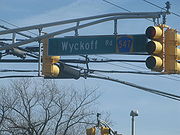
. The road intersects CR 38 again after and enters Eatontown
at the CR 51 junction, where the name becomes Wyckoff Road. A short distance later, the route comes to a partial interchange providing access to and from the southbound direction of the Route 18 freeway before heading into wooded residential neighborhoods. CR 547 widens to a divided highway as it passes the Monmouth Mall
and comes to an intersection with Route 36. The road passes more businesses as it becomes undivided and comes to the Route 35 junction a short distance later. CR 547 continues past more homes before it reaches its northern terminus at Route 71/CR 537
.
County highway
A county highway is a road in the United States and in the Canadian province of Ontario that is designated and/or maintained by the county highway department...
in the U.S. state
U.S. state
A U.S. state is any one of the 50 federated states of the United States of America that share sovereignty with the federal government. Because of this shared sovereignty, an American is a citizen both of the federal entity and of his or her state of domicile. Four states use the official title of...
of New Jersey
New Jersey
New Jersey is a state in the Northeastern and Middle Atlantic regions of the United States. , its population was 8,791,894. It is bordered on the north and east by the state of New York, on the southeast and south by the Atlantic Ocean, on the west by Pennsylvania and on the southwest by Delaware...
. The highway extends 28.29 miles (45.5 km) from Route 70 in Lakehurst
Lakehurst, New Jersey
Lakehurst is a Borough in Ocean County, New Jersey, United States. As of the United States 2010 Census, the borough population was 2,654.Lakehurst was incorporated as a borough by an Act of the New Jersey Legislature on April 7, 1921, from portions of Manchester Township, based on the results of a...
to Broad Street (Route 71/CR 537
County Route 537 (New Jersey)
County Route 537, abbreviated CR 537, is a county highway in the U.S. state of New Jersey. The highway extends from Delaware Avenue in Camden to Myrtle Avenue in Long Branch.-Camden County:...
) in Eatontown
Eatontown, New Jersey
Eatontown is a borough in Monmouth County, New Jersey, United States. As of the 2010 census, the borough population was 12,709.What is now Eatontown was originally incorporated as Eatontown Township by an Act of the New Jersey Legislature on April 4, 1873, from portions of Ocean Township and...
. Near its southern terminus, it passes the East gate of NAVAIR Lakehurst, also known as Lakehurst Naval Air Station in the past, and the site of the crash of the Hindenburg
LZ 129 Hindenburg
LZ 129 Hindenburg was a large German commercial passenger-carrying rigid airship, the lead ship of the Hindenburg class, the longest class of flying machine and the largest airship by envelope volume...
in 1937.
Ocean County
CR 547 begins at an intersection with Route 70 in LakehurstLakehurst, New Jersey
Lakehurst is a Borough in Ocean County, New Jersey, United States. As of the United States 2010 Census, the borough population was 2,654.Lakehurst was incorporated as a borough by an Act of the New Jersey Legislature on April 7, 1921, from portions of Manchester Township, based on the results of a...
, Ocean County
Ocean County, New Jersey
-Demographics:As of the census of 2000, there were 510,916 people, 200,402 households, and 137,876 families residing in the county. The population density was 803 people per square mile . There were 248,711 housing units at an average density of 151/km²...
, heading northeast on two-lane undivided Lakehurst-Lakewood Road. Immediately after beginning, the route crosses the Manasquan Brook into Manchester Township
Manchester Township, New Jersey
Manchester Township is a Township in Ocean County, New Jersey, United States. The township is noted for containing the Lakehurst Naval Air Station, the site of the infamous Hindenburg disaster of May 6, 1937...
and turns north, running through forested areas of the Pine Barrens
Pine Barrens (New Jersey)
The Pine Barrens, also known as the Pinelands, is a heavily forested area of coastal plain stretching across southern New Jersey. The name "pine barrens" refers to the area's sandy, acidic, nutrient-poor soil, to which the crops originally imported by European settlers didn't take well...
to the east of Naval Air Engineering Station Lakehurst
Naval Air Engineering Station Lakehurst
JB MDL Lakehurst is a United States Navy base located approximately south-southeast of Trenton, New Jersey. Lakehurst is under the jurisdiction of the Naval Air Systems Command...
. CR 547 is briefly a four-lane divided highway
Divided Highway
Divided Highway is a compilation album by American rock band The Doobie Brothers, released in 2003. . All tracks are taken from the albums Cycles and Brotherhood .-Track listing:...
as it passes an entrance to the naval station before narrowing back to a two-lane undivided road and entering more dense forests as it comes to the CR 571
County Route 571 (New Jersey)
County Route 571, abbreviated CR 571, is a county highway in the U.S. state of New Jersey. The highway extends from Route 37 in Toms River Township to Route 27 in the Borough of Princeton.-Ocean County:...
junction. From this point, the route becomes Lakehurst-Whitesville Road before continuing into Jackson Township
Jackson Township, New Jersey
-Demographics:As of the census of 2000, there were 42,816 people, 14,176 households, and 11,269 families residing in the township. The population density was 427.9 people per square mile . There were 14,640 housing units at an average density of 146.3 per square mile...
as South Hope Chapel Road, running northeast through more woods with occasional development, crossing an abandoned railroad right-of-way before turning north and intersecting CR 527
County Route 527 (New Jersey)
County Route 527 is a county highway in the U.S. state of New Jersey. The highway extends from Main Street in Toms River Township to Pompton Avenue in Cedar Grove. It is the second longest county highway in New Jersey after Route 519. It was first given the number 527 in 1954...
near homes and businesses. Past this intersection, CR 547 continues north through wooded areas of residences before coming to an intersection with CR 528
County Route 528 (New Jersey)
County Route 528 is a county highway in the U.S. state of New Jersey. The highway extends from Farnsworth Avenue in Bordentown to Ocean Avenue in Mantoloking.-Burlington County:...
near businesses.
At this point, CR 547 turns east to form a concurrency
Concurrency (road)
A concurrency, overlap, or coincidence in a road network is an instance of one physical road bearing two or more different highway, motorway, or other route numbers...
with CR 528 on East Veterans Highway, with CR 639 continuing north on South Hope Chapel Road. The two routes continues through residential and commercial development, intersecting CR 626 before crossing into Lakewood Township
Lakewood Township, New Jersey
-Demographics:As of the census of 2000, there were 60,352 people, 19,876 households, and 13,356 families residing in the township. The population density was 2,431.8 people per square mile . There were 21,214 housing units at an average density of 854.8 per square mile...
. At this point, CR 528/CR 547 becomes Lakewood-New Egypt Road and turns northeast into wooded residential neighborhoods. In this area, the routes turn east onto Central Avenue and passes more homes before crossing Lake Carasaljo
Lake Carasaljo
A man-made lake in the center of Lakewood Township, New Jersey, Lake Carasaljo and its sister, Lake Manetta, were created by the damming a northern tributary of the Metedeconk River in 1883, when Lakewood was the site of the Bergen Iron Works....
and coming to an intersection with US 9. At this point, CR 528 continues northeast on Hurley Avenue and CR 547 turns north to follow US 9 on Madsion Avenue, crossing the Metedeconk River
Metedeconk River
The Metedeconk River of southeastern New Jersey flows from its North Branch and its South Branch to their confluence at Forge Pond, where the river then widens and flows southeast for 6 miles/9.7 km into the Barnegat Bay...
, which Lake Carasaljo is formed from. After intersecting the western terminus of Route 88, Madison Avenue continues north through the commercial and residential center of Lakewood as a four-lane undivided road, with CR 547 splitting from US 9 by turning east onto two-lane 8th Street. The route passes through residential areas before splitting from 8th Street by turning northeast onto Squankum Road. Along this stretch, CR 547 runs through wooded areas of homes, crossing CR 526
County Route 526 (New Jersey)
County Route 526 is a county highway in the U.S. state of New Jersey. The highway extends from Hightstown Road in West Windsor Township to Lanes Mill Road in Lakewood Township....
.
Monmouth County
Howell Township, New Jersey
Howell is a Township in Monmouth County, New Jersey, United States. As of the 2010 United States Census, the township population was 51,075.Howell Township was incorporated as a township by an Act of the New Jersey Legislature on February 23, 1801, from portions of Shrewsbury Township...
in Monmouth County
Monmouth County, New Jersey
Monmouth County is a county located in the U.S. state of New Jersey, within the New York metropolitan area. As of the 2010 Census, the population was 630,380, up from 615,301 at the 2000 census. Its county seat is Freehold Borough. The most populous municipality is Middletown Township with...
and continues through a mix of homes, businesses, and woods as it crosses The Southern Secondary railroad line owned by Conrail Shared Assets Operations
Conrail Shared Assets Operations
Conrail Shared Assets Operations is an American railroad company. It operates three networks—the North Jersey, South Jersey/Philadelphia, and Detroit Shared Assets Areas, where it serves as a local carrier and switching company for CSX Transportation and the Norfolk Southern Railway...
. Farther northeast, the road continues into a mix of farmland, woodland, and residences as it reaches an intersection with CR 549
County Route 549 (New Jersey)
County Route 549 is a county highway in the U.S. state of New Jersey. The highway extends from Main Street at County Route 527 in Toms River Township to County Route 547 at Monmouth CR 21 in Howell Township...
and CR 21. After this, CR 547 turns north and the lanes split as it comes to a cloverleaf interchange
Cloverleaf interchange
A cloverleaf interchange is a two-level interchange in which left turns, reverse direction in left-driving regions, are handled by ramp roads...
with I-195
Interstate 195 (New Jersey)
Interstate 195 is an auxiliary route of the Interstate Highway System located in the U.S. state of New Jersey. Its western end is at I-295 and Route 29 just south of Trenton, New Jersey in Hamilton Township, Mercer County while its eastern end is at the Garden State Parkway, Route 34 and Route...
. The lanes rejoin as the route comes to an intersection with CR 524
County Route 524 (New Jersey)
County Route 524 is a county highway in the U.S. state of New Jersey. The highway extends from the Whitehorse Circle in Hamilton Township to Route 71 in Spring Lake Heights....
and CR 524 Alternate, at which point CR 524 turns north to join CR 547. The two routes continues north through wooded areas of homes and businesses on Lakewood-Farmingdale Road, intersecting CR 18 before entering Farmingdale
Farmingdale, New Jersey
Farmingdale is a borough in Monmouth County, New Jersey, United States. As of the 2010 United States Census, the borough population was 1,329....
and turning northwest. The road becomes Main Street and passes residences before crossing the Southern Secondary into business areas. CR 547 splits from CR 524 by heading northeast on Asbury Avenue, passing some homes before crossing back into Howell Township. The route passes a mix of woodland and residential neighborhoods before making a turn to the east and crossing the Southern Secondary again. CR 547 enters Wall Township
Wall Township, New Jersey
Wall Township is a township in Monmouth County, New Jersey, United States. As of the 2010 United States Census, the township population was 26,164.Wall Township was formally incorporated as a township by an act of the New Jersey Legislature on March 7, 1851...
and runs through wooded areas of industry before intersecting Route 33 and Route 34 at the Collingwood Circle
Collingwood Circle
The Collingwood Circle is a traffic circle in New Jersey. Route 33 and Route 34 split around this circle in Wall Township, New Jersey. CR 547 also intersects the circle....
.
CR 547 heads east for a brief concurrency with four-lane Route 33 after the circle before turning northeast onto four-lane undivided Shafto Road. The road continues into Tinton Falls
Tinton Falls, New Jersey
-Demographics:As of the census of 2000, there were 15,053 people, 5,883 households, and 3,976 families residing in the borough. The population density was 965.7 people per square mile . There were 6,211 housing units at an average density of 398.4 per square mile...
and passes through a mix of farms and woods before continuing into forested areas with some commercial development. Upon crossing CR 16, the road runs between Naval Weapons Station Earle
Naval Weapons Station Earle
Naval Weapons Station Earle is a United States Navy base in New Jersey. Its distinguishing feature is a 2.9-mile pier in Sandy Hook Bay where ammunition can be loaded and unloaded from warships at a safe distance from land....
to the west and wooded residential and commercial development to the east. CR 547 passes through dense forests before intersecting CR 38 and passing under the Garden State Parkway
Garden State Parkway
The Garden State Parkway is a 172.4-mile limited-access toll parkway that stretches the length of New Jersey from the New York line at Montvale, New Jersey, to Cape May at New Jersey's southernmost tip. Its name refers to New Jersey's nickname, the "Garden State." Most New Jersey residents refer...
. The road intersects CR 38 again after and enters Eatontown
Eatontown, New Jersey
Eatontown is a borough in Monmouth County, New Jersey, United States. As of the 2010 census, the borough population was 12,709.What is now Eatontown was originally incorporated as Eatontown Township by an Act of the New Jersey Legislature on April 4, 1873, from portions of Ocean Township and...
at the CR 51 junction, where the name becomes Wyckoff Road. A short distance later, the route comes to a partial interchange providing access to and from the southbound direction of the Route 18 freeway before heading into wooded residential neighborhoods. CR 547 widens to a divided highway as it passes the Monmouth Mall
Monmouth Mall
Monmouth Mall, an enclosed shopping center in Eatontown, New Jersey owned by Vornado Realty Trust, is located on the corner of the intersection of NJ 35, NJ 36, and Wyckoff Road . Currently, the mall has a gross leasable area of , making it the fourth largest shopping mall in New Jersey , boasting...
and comes to an intersection with Route 36. The road passes more businesses as it becomes undivided and comes to the Route 35 junction a short distance later. CR 547 continues past more homes before it reaches its northern terminus at Route 71/CR 537
County Route 537 (New Jersey)
County Route 537, abbreviated CR 537, is a county highway in the U.S. state of New Jersey. The highway extends from Delaware Avenue in Camden to Myrtle Avenue in Long Branch.-Camden County:...
.