

Northeast Corridor
Encyclopedia
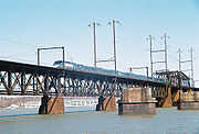
The Northeast Corridor (commonly abbreviated NEC) is a fully electrified railway line owned primarily by Amtrak
serving the Northeast megalopolis
of the United States
from Boston
in the north, via New York
to Washington, D.C.
in the south, with branches serving other cities. The line is used by the Acela Express
and the Northeast Regional between New York and Washington plus other Amtrak routes in addition to commuter rail
services and freight rail transport.
The NEC, which closely parallels Interstate 95
for most of its length, is the busiest passenger rail line in the United States
by ridership and service frequency. The Acela, which entered service in 2000 and is the only high-speed rail
service in the United States, operates at up to 150 mph (241 km/h) on part of the route, taking 2 hours 48 minutes between New York and Washington; for much of the route, however, speed is limited to under 100 mph (161 km/h). Plans have been prepared for a $117-billion (2010 dollars) project to reduce New York–Washington time to 96 minutes and Boston–New York to 84 minutes.
, New York
, a northern suburb of New York City
. The segment from New Rochelle to New Haven is owned by the states of New York and Connecticut; Metro-North Railroad
commuter trains operate on this segment. North of New Haven, ownership again reverts to Amtrak, whose tracks stretch to the border between Rhode Island and Massachusetts. The final segment from the border north to Boston is owned by the Commonwealth of Massachusetts.
 Under Amtrak's ownership, the Northeast Corridor suffered from several high-profile electric-power failures in 2006 and other infrastructure problems. Intermittent power outages caused delays of up to five hours for Amtrak and commuter trains. Railroad officials have blamed Amtrak's funding woes for the deterioration of the track and power supply infrastructure, which in places is almost a hundred years old.
Amtrak owns Pennsylvania Station
in New York, 30th Street Station in Philadelphia, Pennsylvania Station
in Baltimore, and Union Station in Washington.
There are only eleven grade crossings
on the NEC, all in southeastern New London County, Connecticut
, to the north of New York. Except for three grade crossings in New London, Connecticut
(which are in close proximity to the station), all crossings feature four-quadrant gate
s without exit gate delays as well as induction loop
s to alert Amtrak personnel about trapped vehicles.
(NYNH&H) owned the section from Boston to New York (formerly known as the "Boston & New Haven Main Line" or "Shore Line"), and the Pennsylvania Railroad
(PRR) owned the section from New York to Washington (formerly known as the "Philadelphia-to-Washington Main Line").
From Boston to New York:
A short section in New York was owned jointly by the New York, New Haven and Hartford Railroad and the Pennsylvania Railroad:
The New York to Washington section:
following the opening of the first electrified urban rail terminal in 1900, the Gare d'Orsay
in Paris, France. Electricity was already in use on various branch lines of the NYNH&H for interurban streetcars via third rail
or trolley wire
. A further incentive was provided when an accident killed 17 people on January 8, 1902, which was blamed on low visibility caused by the air pollution of steam locomotive
s. The resulting public outcry led to a push for electric operation in Manhattan
.
The first section of what became the NEC was the Park Avenue Tunnel
of the New York and Harlem Railroad
, part of the New York Central and Hudson River Railroad (NYC) to its Grand Central Terminal
in New York, and also used by the NYNH&H via trackage rights
.
The NYNH&H announced in 1905 that it would electrify its main line from New York to Stamford, Connecticut
. Along with the construction of the new Grand Central Terminal
, opened in 1912, the NYC electrified its lines, beginning on December 11, 1906 with suburban multiple unit
service to High Bridge on the Hudson Line
. Electric locomotive
s began serving Grand Central February 13, 1907, and all NYC passenger service into Grand Central was electrified July 1. NYNH&H electrification began July 24 to New Rochelle
, August 5 to Port Chester
and October 6, 1907 the rest of the way to Stamford. Steam trains last operated into Grand Central on June 30, 1908, after which all NYNH&H passenger trains into Manhattan were electrified. On June 22, 1914 the NYNH&H electrification was extended to New Haven, which was the terminus of electrified service for over 80 years.
At the same time, the PRR was building its Pennsylvania Station
and electrified approaches, served by the PRR's lines in New Jersey
and the Long Island Rail Road
(LIRR). LIRR electric service began in 1905 on the Atlantic Branch from downtown Brooklyn
past Jamaica
, and in June 1910 on the branch to Long Island City
, part of the main line to Penn Station. Penn Station opened September 8, 1910 for LIRR trains and November 27 for the PRR; trains of both railroads were powered by DC
electricity from a third rail. PRR trains changed engines (electric to/from steam) at Manhattan Transfer
; passengers could also transfer there to H&M
trains to downtown Manhattan.
On July 29, 1911, the NYNH&H began electric service on its Harlem River Branch, a suburban branch that would become a main line with the completion of the New York Connecting Railroad
and its Hell Gate Bridge
. The bridge opened on April 1, 1917, but was operated by steam with an engine change at Sunnyside Yard
east of Penn Station until 1918.
Electrification of the portion north of New Haven to Providence and Boston had been planned by the NYNH&H, and authorized by the company's board of directors shortly before the U.S. entered World War I
. This plan was not carried out because of the war and the company's financial problems.
trains west to Paoli
on the PRR Main Line (now the Keystone Corridor
). Electric service to Chestnut Hill (now the Chestnut Hill West Line
), including a stretch of the NEC, began March 30, 1918. Local electric service to Wilmington, Delaware
on the NEC began September 30, 1928, and the other way to Trenton, New Jersey
on June 29, 1930.
The first electrified service between Exchange Place
, the Jersey City terminal, and New Brunswick, New Jersey
began on December 8, 1932, including the extension of Penn Station electric service from Manhattan Transfer. On January 16, 1933, the rest of the electrification, between New Brunswick and Trenton, opened, giving a fully electrified intercity line between New York and Philadelphia, and beyond to Wilmington. Through trains to Washington began running under electricity to Wilmington February 12, with the engine change moved from Manhattan Transfer to Wilmington. The same was done on April 9 for trains running west from Philadelphia, with the change point moved to Paoli.
In 1933, the electrification south of Wilmington was stalled by the Great Depression
, but the PRR managed to get a loan from the federal government to resume work the next year. The tunnels at Baltimore were rebuilt, and electric revenue service between New York and Washington began February 10, 1935. On April 7 the electrification of all New York–Washington passenger trains was complete, with 639 daily trains, 191 locomotive-hauled and the other 448 multiple-unit. New York–Washington electric freight service began May 20 with the electrification of freight lines in New Jersey and Washington. Extensions to Potomac Yard
across the Potomac River
from Washington, as well as several freight branches along the way, were electrified in 1937 and 1938. The Potomac Yard electrification remained until 1981.
set the speed record for a production train at 170.8 miles per hour (274.8 kilometers per hour) on the Northeast Corridor between New Brunswick, New Jersey
and Trenton, New Jersey
in December 1967 shortly before Pennsylvania Railroad merged with its former rival, the New York Central Railroad
in 1969 to form Penn Central Transportation
. This new company then absorbed the NYNH&H in 1969, bringing the whole Washington-Boston corridor under control of one company.
Despite the joining of the New York Connecting Railroad
and Hell Gate Bridge
segments, the two were operated almost entirely independently of each other until the merger of the PRR and NYNH&H into Penn Central Transportation
in 1968 and 1969 respectively, and the establishment of Amtrak in 1971. On September 21, 1970 all New York–Boston trains except the Turboservice were rerouted into Penn Station from Grand Central, and the Turboservice was moved February 1, 1971.
Amtrak took over intercity passenger rail services in the United States on May 1, 1971 and soon began running trains through New York, partly because of poor maintenance at Sunnyside Yard
.
The State of New York bought and the State of Connecticut leased their sections of the New Haven Line, between Woodlawn, New York and New Haven, Connecticut
, from Penn Central in January 1971, which was subsequently operated by the Metropolitan Transportation Authority
. In the same month, the State of Massachusetts bought the Attleboro/Stoughton Line in Massachusetts
, which was subsequently operated by the Massachusetts Bay Transportation Authority
.
The Regional Rail Reorganization Act of 1973 provided for Amtrak to purchase any remaining trackage for the corridor which passed to Amtrak in April 1976 with the formation of Conrail except for the section between New Haven and the Rhode Island/Massachusetts state line, which were sold to the Providence and Worcester Railroad
; those rights remained until the 1999 breakup of Conrail, when they were split between the Norfolk Southern Railway
to the south and CSX Transportation
to the north.
Conrail, another government corporation, was formed in 1976 to take over the now-bankrupt Penn Central Transportation, and sections of the line that had not already been sold to state commuter transportation authorities were sold to Amtrak. The purchase of the Northeast Corridor by Amtrak was controversial at the time, and the Department of Transportation
blocked the transaction and withheld purchase funds for several months until Amtrak granted it control over reconstruction of the corridor.
The Preliminary System Plan for Conrail, prepared in February 1975, proposed abandoning all freight on the Shore Line (NEC) between Groton, Connecticut
and Hills Grove, Rhode Island. However, in March 1975, the U.S. Railway Association
announced that it had re-evaluated the line segment and would be keeping it in operation. Amtrak now operates and maintains the portion in Massachusetts, but the line from New Haven to New Rochelle, New York
is operated by the Metro-North Railroad
; this has been a problem with establishment of high-speed service.
authorized the Northeast Corridor Improvement Project (NECIP) to begin a major overhaul and improvement of the system between Washington and Boston. The project included safety improvements, modernization of the signaling system by General Railway Signal
and new Centralized Electrification and Traffic Control (CETC) control centers by Chrysler
at Philadelphia, New York and Boston. It allowed more trains to run faster and closer together, and set the stage for later high-speed
operation. NECIP also introduced the AEM-7 locomotive, which enabled lower travel times between cities, and it became the most successful engine on the Corridor. The NECIP set travel time goals of 2 hours and 30 minutes between Washington and New York, and 3 hours between Boston and New York. These goals were not met because of the low level of funding provided by the Reagan Administration and Congress in the 1980s.
A project for electrification between New Haven and Boston had been included in a bill signed by President Gerald Ford
in 1976 but then stalled after 1980 because of opposition from the Reagan Administration
.
All grade crossings on the line have been eliminated between New York and Washington since the mid-1980s. Eleven grade crossings remain in Connecticut.
The Northeast High Speed Rail Improvement Program (NHRIP), was implemented in the 1990s. In preparation for the new higher-speed Acela Express
trains, Amtrak upgraded the portion of the Northeast Corridor north of New York; grade crossings
were eliminated, some bridges were rebuilt, and some curves were modified. Beginning in 1996, the electrification was extended north along the 157-mile (253 km) section of track between New Haven and Boston with electric locomotives starting service on January 31, 2000. Concrete railroad tie
s replaced wood, and heavier continuous welded rail (CWR) was laid down.
Acela Express service began on December 11, 2000. Travel time between Boston and New York is about three and a half hours, and New York–Washington runs take two hours and forty-five minutes.
between Newark Penn Station and New York Penn Station.
. The work will allow dedicated tracks to the New York Connecting Railroad
right of way for Amtrak trains arriving from or bound for New England
, thus avoiding NJT and LIRR traffic.
Financing for the project was jeopardized in July 2011 by the House of Representatives
, which voted to divert the funding to unrelated projects.
and Trenton
to improve reliability, increase speeds up to 160 mile per hour, and support more frequent high-speed service. Funding for the project and others announced at the same time had not been "obligated" by Congress and may be diverted by a bill passed by the House of Representatives
in July 2011.
) over the Hutchinson River in The Bronx
. The goal is for a new bridge to support expanded service and speeds up to 110 mph (177 kph).
in October 2010. At a cost of approximately $117 billion (2010 dollars), it would allow speeds of 220 mph and reduce the travel time from New York to Washington, including a stop in Philadelphia, to 96 minutes, and the travel time from Boston to New York to 84 minutes.
The proposed alignment would closely follow the existing Northeast Corridor south of New York City
with a number of different alignments to be studied north of New York City. One option would be through interior Connecticut
paralleling Interstates 684
, 84
, and 90
(via Danbury
, Waterbury
, and Hartford
); another would follow the existing shoreline route (paralleling Interstate 95
); a third would route via Long Island
, which would require the construction of the Long Island Sound link
across Long Island Sound
to Connecticut.
, Springfield, Massachusetts
, New York City
and Washington D.C. with multiple trains per day. The Atlantic City Express Service
is a train to/from Atlantic City
on Fridays, Saturdays, and Sundays. The Cardinal is a second train to/from Chicago
through Washington D.C. along the Northeast Corridor on Wednesdays, Fridays, and Sundays. Both the Atlantic City Express Service
and the Cardinal run three days a week.
Amtrak accounts for about 14% of all intercity trips between Northeast Corridor cities and its branches. The rest of these intercity trips are taken by airline, automobile, or coach.
Amtrak and other long-distance trains serving Northeast Corridor stations:
. The Norfolk Southern Railway
operates over the line south of Philadelphia, and CSX Transportation
has rights from New York to New Haven and in Massachusetts. CSX also has rights between Landover, MD and Bowie, MD, where the CSX Landover Subdivision and Pope's Creek Subdivision, respectively, diverge from the NEC. Between Philadelphia and New York, Conrail, which formerly provided service on the whole line, still operates over the line, as a local switching and terminal company for both CSX and Norfolk Southern. (See Conrail Shared Assets Operations
.) The Providence and Worcester Railroad
operates local freight service from New Haven into Rhode Island and has incidental trackage rights
from New Haven to New York.
Amtrak
The National Railroad Passenger Corporation, doing business as Amtrak , is a government-owned corporation that was organized on May 1, 1971, to provide intercity passenger train service in the United States. "Amtrak" is a portmanteau of the words "America" and "track". It is headquartered at Union...
serving the Northeast megalopolis
Northeast megalopolis
The Northeast megalopolis or Boston–Washington megalopolis is the heavily urbanized area of the United States stretching from the the northern suburbs of Boston, Massachusetts to the southern suburbs of Washington, D.C. On a map, the region appears almost as a perfectly straight line. As of 2000,...
of the United States
United States
The United States of America is a federal constitutional republic comprising fifty states and a federal district...
from Boston
Boston
Boston is the capital of and largest city in Massachusetts, and is one of the oldest cities in the United States. The largest city in New England, Boston is regarded as the unofficial "Capital of New England" for its economic and cultural impact on the entire New England region. The city proper had...
in the north, via New York
New York City
New York is the most populous city in the United States and the center of the New York Metropolitan Area, one of the most populous metropolitan areas in the world. New York exerts a significant impact upon global commerce, finance, media, art, fashion, research, technology, education, and...
to Washington, D.C.
Washington, D.C.
Washington, D.C., formally the District of Columbia and commonly referred to as Washington, "the District", or simply D.C., is the capital of the United States. On July 16, 1790, the United States Congress approved the creation of a permanent national capital as permitted by the U.S. Constitution....
in the south, with branches serving other cities. The line is used by the Acela Express
Acela Express
The Acela Express is Amtrak's high-speed rail service along the Northeast Corridor in the Northeast United States between Washington, D.C., and Boston via Baltimore, Philadelphia, and New York...
and the Northeast Regional between New York and Washington plus other Amtrak routes in addition to commuter rail
Commuter rail in North America
Commuter rail services in the United States, Canada, and Mexico provide common carrier passenger transportation along railway tracks, with scheduled service on fixed routes on a non-reservation basis primarily for short-distance travel between a central business district and adjacent suburbs and...
services and freight rail transport.
The NEC, which closely parallels Interstate 95
Interstate 95
Interstate 95 is the main highway on the East Coast of the United States, running parallel to the Atlantic Ocean from Maine to Florida and serving some of the most populated urban areas in the country, including Boston, Providence, New Haven, New York City, Newark, Philadelphia, Baltimore,...
for most of its length, is the busiest passenger rail line in the United States
United States
The United States of America is a federal constitutional republic comprising fifty states and a federal district...
by ridership and service frequency. The Acela, which entered service in 2000 and is the only high-speed rail
High-speed rail in the United States
High-speed rail in the United States currently consists of one high-speed rail service: Amtrak's Acela Express runs on the Northeast Corridor from Boston to Washington, D.C...
service in the United States, operates at up to 150 mph (241 km/h) on part of the route, taking 2 hours 48 minutes between New York and Washington; for much of the route, however, speed is limited to under 100 mph (161 km/h). Plans have been prepared for a $117-billion (2010 dollars) project to reduce New York–Washington time to 96 minutes and Boston–New York to 84 minutes.
Description
With primarily passenger services, the Northeast Corridor is a cooperative venture between Amtrak and various state agencies. Amtrak owns the track between Washington and New RochelleNew Rochelle, New York
New Rochelle is a city in Westchester County, New York, United States, in the southeastern portion of the state.The town was settled by refugee Huguenots in 1688 who were fleeing persecution in France...
, New York
New York
New York is a state in the Northeastern region of the United States. It is the nation's third most populous state. New York is bordered by New Jersey and Pennsylvania to the south, and by Connecticut, Massachusetts and Vermont to the east...
, a northern suburb of New York City
New York City
New York is the most populous city in the United States and the center of the New York Metropolitan Area, one of the most populous metropolitan areas in the world. New York exerts a significant impact upon global commerce, finance, media, art, fashion, research, technology, education, and...
. The segment from New Rochelle to New Haven is owned by the states of New York and Connecticut; Metro-North Railroad
Metro-North Railroad
The Metro-North Commuter Railroad , trading as MTA Metro-North Railroad, or, more commonly, Metro-North, is a suburban commuter rail service that is run and managed by the Metropolitan Transportation Authority , an authority of New York State. It is the busiest commuter railroad in the United...
commuter trains operate on this segment. North of New Haven, ownership again reverts to Amtrak, whose tracks stretch to the border between Rhode Island and Massachusetts. The final segment from the border north to Boston is owned by the Commonwealth of Massachusetts.
Amtrak owns Pennsylvania Station
Pennsylvania Station (New York City)
Pennsylvania Station—commonly known as Penn Station—is the major intercity train station and a major commuter rail hub in New York City. It is one of the busiest rail stations in the world, and a hub for inbound and outbound railroad traffic in New York City. The New York City Subway system also...
in New York, 30th Street Station in Philadelphia, Pennsylvania Station
Pennsylvania Station (Baltimore)
Pennsylvania Station is the main train station in Baltimore, Maryland. Designed by New York architect Kenneth MacKenzie Murchison , it was constructed in 1911 in the Beaux-Arts style of architecture for the Pennsylvania Railroad. It is located at 1515 N...
in Baltimore, and Union Station in Washington.
There are only eleven grade crossings
Level crossing
A level crossing occurs where a railway line is intersected by a road or path onone level, without recourse to a bridge or tunnel. It is a type of at-grade intersection. The term also applies when a light rail line with separate right-of-way or reserved track crosses a road in the same fashion...
on the NEC, all in southeastern New London County, Connecticut
New London County, Connecticut
New London County is a county located in the southeastern corner of the U.S. state of Connecticut. As of 2010 the population was 274,055. The total area of the county is , including inland and coastal waters....
, to the north of New York. Except for three grade crossings in New London, Connecticut
New London, Connecticut
New London is a seaport city and a port of entry on the northeast coast of the United States.It is located at the mouth of the Thames River in New London County, southeastern Connecticut....
(which are in close proximity to the station), all crossings feature four-quadrant gate
Four-quadrant gate
A four-quadrant gate is a type of boom barrier gate protecting a grade crossing.It has a gate mechanism on both sides of the tracks for both directions of automotive traffic...
s without exit gate delays as well as induction loop
Induction loop
Induction loop is a term used to describe an electromagnetic communication- and detection system, relying on the fact that a moving magnet will induce an electrical current in a nearby conducting wire. Induction loops are used for transmission and reception of communication signals, or for...
s to alert Amtrak personnel about trapped vehicles.
Origins
The current Northeast Corridor was built by a number of different companies between 1830s and 1917. The route was later owned by two companies: the New York, New Haven and Hartford RailroadNew York, New Haven and Hartford Railroad
The New York, New Haven and Hartford Railroad , was a railroad that operated in the northeast United States from 1872 to 1968 which served the states of Connecticut, New York, Rhode Island, and Massachusetts...
(NYNH&H) owned the section from Boston to New York (formerly known as the "Boston & New Haven Main Line" or "Shore Line"), and the Pennsylvania Railroad
Pennsylvania Railroad
The Pennsylvania Railroad was an American Class I railroad, founded in 1846. Commonly referred to as the "Pennsy", the PRR was headquartered in Philadelphia, Pennsylvania....
(PRR) owned the section from New York to Washington (formerly known as the "Philadelphia-to-Washington Main Line").
From Boston to New York:
- Boston to ProvidenceProvidence, Rhode IslandProvidence is the capital and most populous city of Rhode Island and was one of the first cities established in the United States. Located in Providence County, it is the third largest city in the New England region...
: Boston and Providence Railroad opened 1835, partially realigned in 1847 and in 1899. Became part of the Old Colony RailroadOld Colony RailroadThe Old Colony Railroad was a major railroad system, mainly covering southeastern Massachusetts and parts of Rhode Island. It operated from 1845 to 1893. Old Colony trains ran from Boston to points such as Plymouth, Fall River, New Bedford, Newport, Providence, Fitchburg, Lowell and Cape Cod...
in 1888. - Providence to StoningtonStonington, ConnecticutThe Town of Stonington is located in New London County, Connecticut, in the state's southeastern corner. It includes the borough of Stonington, the villages of Pawcatuck, Lords Point, Wequetequock, the eastern halves of the villages of Mystic and Old Mystic...
: New York, Providence and Boston RailroadNew York, Providence and Boston RailroadThe New York, Providence and Boston Railroad, normally called the Stonington Line, was a major part of the New York, New Haven and Hartford Railroad between New London, Connecticut and Providence, Rhode Island...
opened 1837; partially realigned 1848. - Stonington to New HavenNew Haven, ConnecticutNew Haven is the second-largest city in Connecticut and the sixth-largest in New England. According to the 2010 Census, New Haven's population increased by 5.0% between 2000 and 2010, a rate higher than that of the State of Connecticut, and higher than that of the state's five largest cities, and...
: New Haven, New London and Stonington Railroad opened 1852-1889, realigned in New Haven, 1894. - New Haven to New RochelleNew Rochelle, New YorkNew Rochelle is a city in Westchester County, New York, United States, in the southeastern portion of the state.The town was settled by refugee Huguenots in 1688 who were fleeing persecution in France...
: New York and New Haven RailroadNew York and New Haven RailroadThe New York and New Haven Railroad was a railroad connecting New York City to New Haven, Connecticut along the shore of the Long Island Sound. It opened in 1849, and in 1872 it merged with the Hartford and New Haven Railroad to form the New York, New Haven and Hartford Railroad...
opened 1849. - New Rochelle to Port Morris): Harlem River and Port Chester RailroadHarlem River and Port Chester RailroadThe Harlem River and Port Chester Railroad was a branch of the New York, New Haven and Hartford Railroad, upgraded to main line status in 1917 with the completion of the New York Connecting Railroad and its Hell Gate Bridge...
opened 1873.
A short section in New York was owned jointly by the New York, New Haven and Hartford Railroad and the Pennsylvania Railroad:
- Port Morris to Sunnyside YardSunnyside YardSunnyside Yard is a large coach yard, a railroad yard for passenger cars, in Sunnyside, Queens in New York City.-Description:The yard is owned by Amtrak and is also used by New Jersey Transit. The shared tracks of the Long Island Rail Road Main Line and Amtrak's Northeast Corridor pass along the...
: New York Connecting RailroadNew York Connecting RailroadThe New York Connecting Railroad or NYCR is a rail line in the borough of Queens in New York City. It links New York City and Long Island by rail directly to the North American mainland. Amtrak, CSX, Canadian Pacific Railway, Providence and Worcester Railroad and New York and Atlantic Railway...
: opened 1917.
The New York to Washington section:
- Sunnyside Yard to Manhattan TransferManhattan Transfer (PRR station)Manhattan Transfer was a passenger station in Harrison, New Jersey, east of Newark, 8.8 miles west of New York Penn Station on the Pennsylvania Railroad main line, now Amtrak's Northeast Corridor...
: Pennsylvania Tunnel and Terminal RailroadPennsylvania Tunnel and Terminal RailroadThe New York Tunnel Extension , was a major project of the Pennsylvania Railroad at the beginning of the 20th century, to improve railroad access throughout the greater New York City area...
opened 1910. - Manhattan Transfer to TrentonTrenton, New JerseyTrenton is the capital of the U.S. state of New Jersey and the county seat of Mercer County. As of the 2010 United States Census, Trenton had a population of 84,913...
: United New Jersey Railroad and Canal CompanyUnited New Jersey Railroad and Canal CompanyThe United New Jersey Railroad and Canal Company was part of the Pennsylvania Railroad system in New Jersey, including their main line to New York City...
opened 1834-1839, 1841; partially realigned 1863 and 1870. - Trenton to Frankford JunctionFrankford Junction, PennsylvaniaFrankford Junction is a railroad junction, and former junction station, located on the border between the Kensington and Port Richmond neighborhoods of Philadelphia, Pennsylvania, in the United States...
: Philadelphia and Trenton RailroadPhiladelphia and Trenton RailroadThe Philadelphia and Trenton Railroad was a railroad from Philadelphia, Pennsylvania to Trenton, New Jersey that became part of the Pennsylvania Railroad system. The majority of it is now part of Amtrak's Northeast Corridor.-History:...
opened 1834; partially realigned 1911. - Frankford Junction to Zoo Tower: Connecting RailwayConnecting RailwayThe Connecting Railway was a subsidiary of the Pennsylvania Railroad, incorporated to build a connection between the Philadelphia and Trenton Railroad and the PRR in the city of Philadelphia.-Connecting railway:...
opened 1867. - Zoo Tower to Grays FerryGrays Ferry, Philadelphia, PennsylvaniaGrays Ferry, also known as Gray's Ferry, is a neighborhood in South Philadelphia bounded by 25th Street on the east, the Schuylkill River on the west, Vare Avenue on the south, and Grays Ferry Avenue on the north. The section of this neighborhood west of 34th Street is also known as The Forgotten...
: Junction RailroadJunction Railroad (Philadelphia)The Junction Railroad was a railroad in the U.S. state of Pennsylvania, connecting lines west of downtown Philadelphia, Pennsylvania. It came under Pennsylvania Railroad control in 1881, and was eliminated by merger in 1908.-History:...
opened 1863-1866. - Grays Ferry to Bayview: Philadelphia, Wilmington and Baltimore RailroadPhiladelphia, Wilmington and Baltimore RailroadThe Philadelphia, Wilmington and Baltimore Railroad was the Pennsylvania Railroad's main line from Philadelphia, Pennsylvania southwest to Baltimore, Maryland in the 19th and early 20th centuries...
opened 1837-1838, 1866, 1906. - Bayview Yard to Baltimore Union Station: Union Railroad opened 1873.
- Bayview Yard to Baltimore Union Station: Baltimore and Potomac Rail RoadBaltimore and Potomac Rail RoadThe Baltimore and Potomac Railroad operated from Baltimore, Maryland, southwest to Washington, DC, from 1872 to 1902. The company was controlled by the Pennsylvania Railroad. It was the second railroad company to provide railroad service from Washington to the northeastern states, and became a...
opened 1872-1873. - Landover to Washington, D.C.Washington, D.C.Washington, D.C., formally the District of Columbia and commonly referred to as Washington, "the District", or simply D.C., is the capital of the United States. On July 16, 1790, the United States Congress approved the creation of a permanent national capital as permitted by the U.S. Constitution....
: Magruder Branch opened 1907, 1905.
New York section electrification
The New York Central began planning for electrification between Grand Central and the split at Mott HavenMott Haven, Bronx
Mott Haven is a primarily residential neighborhood in the Southwestern section of The Bronx in New York City. Zip codes include 10451, 10454, and 10455. The neighborhood is part of Bronx Community Board 1...
following the opening of the first electrified urban rail terminal in 1900, the Gare d'Orsay
Gare d'Orsay
Gare d'Orsay is a former Paris railway station and hotel, built in 1900 to designs by Victor Laloux, Lucien Magne and Émile Bénard; it served as a terminus for the Chemin de Fer de Paris à Orléans . It was the first electrified urban rail terminal in the world, opened 28 May 1900, in time for the...
in Paris, France. Electricity was already in use on various branch lines of the NYNH&H for interurban streetcars via third rail
Third rail
A third rail is a method of providing electric power to a railway train, through a semi-continuous rigid conductor placed alongside or between the rails of a railway track. It is used typically in a mass transit or rapid transit system, which has alignments in its own corridors, fully or almost...
or trolley wire
Trolley Wire
Trolley Wire is the magazine of the Sydney Tramway Museum in Loftus, New South Wales but is also co-published by most of the other albeit smaller tramway museums around the nation....
. A further incentive was provided when an accident killed 17 people on January 8, 1902, which was blamed on low visibility caused by the air pollution of steam locomotive
Steam locomotive
A steam locomotive is a railway locomotive that produces its power through a steam engine. These locomotives are fueled by burning some combustible material, usually coal, wood or oil, to produce steam in a boiler, which drives the steam engine...
s. The resulting public outcry led to a push for electric operation in Manhattan
Manhattan
Manhattan is the oldest and the most densely populated of the five boroughs of New York City. Located primarily on the island of Manhattan at the mouth of the Hudson River, the boundaries of the borough are identical to those of New York County, an original county of the state of New York...
.
The first section of what became the NEC was the Park Avenue Tunnel
Park Avenue Tunnel (railroad)
The Park Avenue Tunnel connects four tracks of the Metro-North Railroad from Grand Central Terminal at 42nd Street to 97th Street in the New York City borough of Manhattan. The tunnel portal rises to a full viaduct by 99th Street.- History :...
of the New York and Harlem Railroad
New York and Harlem Railroad
The New York and Harlem Railroad was one of the first railroads in the United States, and possibly also the world's first street railway. Designed by John Stephenson, it was opened in stages between 1832 and 1852 between Lower Manhattan to and beyond Harlem...
, part of the New York Central and Hudson River Railroad (NYC) to its Grand Central Terminal
Grand Central Terminal
Grand Central Terminal —often incorrectly called Grand Central Station, or shortened to simply Grand Central—is a terminal station at 42nd Street and Park Avenue in Midtown Manhattan in New York City, United States...
in New York, and also used by the NYNH&H via trackage rights
Trackage rights
Trackage rights , running rights or running powers is an agreement whereby a railway company has the right to run its trains on tracks owned by another railway company....
.
The NYNH&H announced in 1905 that it would electrify its main line from New York to Stamford, Connecticut
Stamford, Connecticut
Stamford is a city in Fairfield County, Connecticut, United States. According to the 2010 census, the population of the city is 122,643, making it the fourth largest city in the state and the eighth largest city in New England...
. Along with the construction of the new Grand Central Terminal
Grand Central Terminal
Grand Central Terminal —often incorrectly called Grand Central Station, or shortened to simply Grand Central—is a terminal station at 42nd Street and Park Avenue in Midtown Manhattan in New York City, United States...
, opened in 1912, the NYC electrified its lines, beginning on December 11, 1906 with suburban multiple unit
Multiple unit
The term multiple unit or MU is used to describe a self-propelled carriages capable of coupling with other units of the same or similar type and still being controlled from one driving cab. The term is commonly used to denote passenger trainsets consisting of more than one carriage...
service to High Bridge on the Hudson Line
Hudson Line (Metro-North)
Metro-North Railroad's Hudson Line is a commuter rail line running north from New York City along the east shore of the Hudson River. Metro-North service ends at Poughkeepsie, with Amtrak's Empire Corridor trains continuing north to and beyond Albany...
. Electric locomotive
Electric locomotive
An electric locomotive is a locomotive powered by electricity from overhead lines, a third rail or an on-board energy storage device...
s began serving Grand Central February 13, 1907, and all NYC passenger service into Grand Central was electrified July 1. NYNH&H electrification began July 24 to New Rochelle
New Rochelle, New York
New Rochelle is a city in Westchester County, New York, United States, in the southeastern portion of the state.The town was settled by refugee Huguenots in 1688 who were fleeing persecution in France...
, August 5 to Port Chester
Port Chester, New York
Port Chester is a village in Westchester County, New York, United States. The village is part of the town of Rye. As of the 2010 census, Port Chester had a population of 28,967...
and October 6, 1907 the rest of the way to Stamford. Steam trains last operated into Grand Central on June 30, 1908, after which all NYNH&H passenger trains into Manhattan were electrified. On June 22, 1914 the NYNH&H electrification was extended to New Haven, which was the terminus of electrified service for over 80 years.
At the same time, the PRR was building its Pennsylvania Station
Pennsylvania Station (New York City)
Pennsylvania Station—commonly known as Penn Station—is the major intercity train station and a major commuter rail hub in New York City. It is one of the busiest rail stations in the world, and a hub for inbound and outbound railroad traffic in New York City. The New York City Subway system also...
and electrified approaches, served by the PRR's lines in New Jersey
New Jersey
New Jersey is a state in the Northeastern and Middle Atlantic regions of the United States. , its population was 8,791,894. It is bordered on the north and east by the state of New York, on the southeast and south by the Atlantic Ocean, on the west by Pennsylvania and on the southwest by Delaware...
and the Long Island Rail Road
Long Island Rail Road
The Long Island Rail Road or LIRR is a commuter rail system serving the length of Long Island, New York. It is the busiest commuter railroad in North America, serving about 81.5 million passengers each year. Established in 1834 and having operated continuously since then, it is the oldest US...
(LIRR). LIRR electric service began in 1905 on the Atlantic Branch from downtown Brooklyn
Downtown Brooklyn
Downtown Brooklyn is the third largest central business district in New York City , and is located in the northwestern section of the borough of Brooklyn...
past Jamaica
Jamaica (LIRR station)
Jamaica is a major hub station of the Long Island Rail Road, and is located in Jamaica, Queens, New York City. It is the largest transit hub on Long Island and is one of the busiest railroad stations in the country with over 200,000 daily passengers...
, and in June 1910 on the branch to Long Island City
Long Island City, Queens
Long Island City is the westernmost neighborhood of the borough of Queens in New York City. L.I.C. is notable for its rapid and ongoing gentrification, its waterfront parks, and its thriving arts community. L.I.C. has among the highest concentration of art galleries, art institutions, and studio...
, part of the main line to Penn Station. Penn Station opened September 8, 1910 for LIRR trains and November 27 for the PRR; trains of both railroads were powered by DC
Direct current
Direct current is the unidirectional flow of electric charge. Direct current is produced by such sources as batteries, thermocouples, solar cells, and commutator-type electric machines of the dynamo type. Direct current may flow in a conductor such as a wire, but can also flow through...
electricity from a third rail. PRR trains changed engines (electric to/from steam) at Manhattan Transfer
Manhattan Transfer (PRR station)
Manhattan Transfer was a passenger station in Harrison, New Jersey, east of Newark, 8.8 miles west of New York Penn Station on the Pennsylvania Railroad main line, now Amtrak's Northeast Corridor...
; passengers could also transfer there to H&M
Port Authority Trans-Hudson
PATH, derived from Port Authority Trans-Hudson, is a rapid transit railroad linking Manhattan, New York City with Newark, Harrison, Hoboken and Jersey City in metropolitan northern New Jersey...
trains to downtown Manhattan.
On July 29, 1911, the NYNH&H began electric service on its Harlem River Branch, a suburban branch that would become a main line with the completion of the New York Connecting Railroad
New York Connecting Railroad
The New York Connecting Railroad or NYCR is a rail line in the borough of Queens in New York City. It links New York City and Long Island by rail directly to the North American mainland. Amtrak, CSX, Canadian Pacific Railway, Providence and Worcester Railroad and New York and Atlantic Railway...
and its Hell Gate Bridge
Hell Gate Bridge
The Hell Gate Bridge or Hell's Gate Bridge is a steel through arch railroad bridge between Astoria in the borough of Queens and Randall's and Wards Islands in New York City, over a portion of the East River known...
. The bridge opened on April 1, 1917, but was operated by steam with an engine change at Sunnyside Yard
Sunnyside Yard
Sunnyside Yard is a large coach yard, a railroad yard for passenger cars, in Sunnyside, Queens in New York City.-Description:The yard is owned by Amtrak and is also used by New Jersey Transit. The shared tracks of the Long Island Rail Road Main Line and Amtrak's Northeast Corridor pass along the...
east of Penn Station until 1918.
Electrification of the portion north of New Haven to Providence and Boston had been planned by the NYNH&H, and authorized by the company's board of directors shortly before the U.S. entered World War I
World War I
World War I , which was predominantly called the World War or the Great War from its occurrence until 1939, and the First World War or World War I thereafter, was a major war centred in Europe that began on 28 July 1914 and lasted until 11 November 1918...
. This plan was not carried out because of the war and the company's financial problems.
New York to Washington electrification
In 1905 Pennsylvania Railroad (PRR) announced that it would electrify its suburban lines at Philadelphia; eventually the 11-kV 25-Hz AC catenary was extended all the way between New York and Washington. Electric service began September 11, 1915 with multiple unitMultiple unit
The term multiple unit or MU is used to describe a self-propelled carriages capable of coupling with other units of the same or similar type and still being controlled from one driving cab. The term is commonly used to denote passenger trainsets consisting of more than one carriage...
trains west to Paoli
Paoli, Pennsylvania
Paoli is a census-designated place in Chester County near Philadelphia, Pennsylvania, United States. It is situated in portions of two townships: Tredyffrin and Willistown...
on the PRR Main Line (now the Keystone Corridor
Keystone Corridor
The Keystone Corridor is a Federal Railroad Administration "designated high speed corridor" with a 349-mile railroad line between Philadelphia, Pennsylvania and Pittsburgh, Pennsylvania with a top speed of...
). Electric service to Chestnut Hill (now the Chestnut Hill West Line
Chestnut Hill West Line
The Chestnut Hill West Line , is a route of the SEPTA Regional Rail system. The route serves the northwestern section of Philadelphia with service to Germantown, Mount Airy, and Chestnut Hill...
), including a stretch of the NEC, began March 30, 1918. Local electric service to Wilmington, Delaware
Wilmington, Delaware
Wilmington is the largest city in the state of Delaware, United States, and is located at the confluence of the Christina River and Brandywine Creek, near where the Christina flows into the Delaware River. It is the county seat of New Castle County and one of the major cities in the Delaware Valley...
on the NEC began September 30, 1928, and the other way to Trenton, New Jersey
Trenton, New Jersey
Trenton is the capital of the U.S. state of New Jersey and the county seat of Mercer County. As of the 2010 United States Census, Trenton had a population of 84,913...
on June 29, 1930.
The first electrified service between Exchange Place
Exchange Place (PRR station)
The Pennsylvania Railroad Station was the intermodal passenger terminal for the Pennsylvania Railroad's vast holdings on the Hudson River and Upper New York Bay in Jersey City, New Jersey. By the 1920s the station was called Exchange Place in response to local nomenclature...
, the Jersey City terminal, and New Brunswick, New Jersey
New Brunswick, New Jersey
New Brunswick is a city in Middlesex County, New Jersey, USA. It is the county seat and the home of Rutgers University. The city is located on the Northeast Corridor rail line, southwest of Manhattan, on the southern bank of the Raritan River. At the 2010 United States Census, the population of...
began on December 8, 1932, including the extension of Penn Station electric service from Manhattan Transfer. On January 16, 1933, the rest of the electrification, between New Brunswick and Trenton, opened, giving a fully electrified intercity line between New York and Philadelphia, and beyond to Wilmington. Through trains to Washington began running under electricity to Wilmington February 12, with the engine change moved from Manhattan Transfer to Wilmington. The same was done on April 9 for trains running west from Philadelphia, with the change point moved to Paoli.
In 1933, the electrification south of Wilmington was stalled by the Great Depression
Great Depression
The Great Depression was a severe worldwide economic depression in the decade preceding World War II. The timing of the Great Depression varied across nations, but in most countries it started in about 1929 and lasted until the late 1930s or early 1940s...
, but the PRR managed to get a loan from the federal government to resume work the next year. The tunnels at Baltimore were rebuilt, and electric revenue service between New York and Washington began February 10, 1935. On April 7 the electrification of all New York–Washington passenger trains was complete, with 639 daily trains, 191 locomotive-hauled and the other 448 multiple-unit. New York–Washington electric freight service began May 20 with the electrification of freight lines in New Jersey and Washington. Extensions to Potomac Yard
Potomac Yard
Potomac Yard was one of the busiest rail yards on the Eastern Seaboard of the United States. Today, it refers to the neighborhood encompassing the same, which straddles southeastern Arlington County and northern Alexandria, Virginia, bounded by U.S. Route 1, the George Washington Memorial Parkway,...
across the Potomac River
Potomac River
The Potomac River flows into the Chesapeake Bay, located along the mid-Atlantic coast of the United States. The river is approximately long, with a drainage area of about 14,700 square miles...
from Washington, as well as several freight branches along the way, were electrified in 1937 and 1938. The Potomac Yard electrification remained until 1981.
Reorganization, bankruptcy and Amtrak
The UAC TurbotrainTurbo (train)
The UAC TurboTrain was an early high-speed, gas turbine train manufactured by United Aircraft Corporation that operated in Canada between 1968 and 1984 and in the United States between 1968 and 1976...
set the speed record for a production train at 170.8 miles per hour (274.8 kilometers per hour) on the Northeast Corridor between New Brunswick, New Jersey
New Brunswick, New Jersey
New Brunswick is a city in Middlesex County, New Jersey, USA. It is the county seat and the home of Rutgers University. The city is located on the Northeast Corridor rail line, southwest of Manhattan, on the southern bank of the Raritan River. At the 2010 United States Census, the population of...
and Trenton, New Jersey
Trenton, New Jersey
Trenton is the capital of the U.S. state of New Jersey and the county seat of Mercer County. As of the 2010 United States Census, Trenton had a population of 84,913...
in December 1967 shortly before Pennsylvania Railroad merged with its former rival, the New York Central Railroad
New York Central Railroad
The New York Central Railroad , known simply as the New York Central in its publicity, was a railroad operating in the Northeastern United States...
in 1969 to form Penn Central Transportation
Penn Central Transportation
The Penn Central Transportation Company, commonly abbreviated to Penn Central, was an American railroad company that operated from 1968 until 1976. It was created by the merger on February 1, 1968, of the Pennsylvania Railroad and the New York Central Railroad...
. This new company then absorbed the NYNH&H in 1969, bringing the whole Washington-Boston corridor under control of one company.
Despite the joining of the New York Connecting Railroad
New York Connecting Railroad
The New York Connecting Railroad or NYCR is a rail line in the borough of Queens in New York City. It links New York City and Long Island by rail directly to the North American mainland. Amtrak, CSX, Canadian Pacific Railway, Providence and Worcester Railroad and New York and Atlantic Railway...
and Hell Gate Bridge
Hell Gate Bridge
The Hell Gate Bridge or Hell's Gate Bridge is a steel through arch railroad bridge between Astoria in the borough of Queens and Randall's and Wards Islands in New York City, over a portion of the East River known...
segments, the two were operated almost entirely independently of each other until the merger of the PRR and NYNH&H into Penn Central Transportation
Penn Central Transportation
The Penn Central Transportation Company, commonly abbreviated to Penn Central, was an American railroad company that operated from 1968 until 1976. It was created by the merger on February 1, 1968, of the Pennsylvania Railroad and the New York Central Railroad...
in 1968 and 1969 respectively, and the establishment of Amtrak in 1971. On September 21, 1970 all New York–Boston trains except the Turboservice were rerouted into Penn Station from Grand Central, and the Turboservice was moved February 1, 1971.
Amtrak took over intercity passenger rail services in the United States on May 1, 1971 and soon began running trains through New York, partly because of poor maintenance at Sunnyside Yard
Sunnyside Yard
Sunnyside Yard is a large coach yard, a railroad yard for passenger cars, in Sunnyside, Queens in New York City.-Description:The yard is owned by Amtrak and is also used by New Jersey Transit. The shared tracks of the Long Island Rail Road Main Line and Amtrak's Northeast Corridor pass along the...
.
The State of New York bought and the State of Connecticut leased their sections of the New Haven Line, between Woodlawn, New York and New Haven, Connecticut
New Haven, Connecticut
New Haven is the second-largest city in Connecticut and the sixth-largest in New England. According to the 2010 Census, New Haven's population increased by 5.0% between 2000 and 2010, a rate higher than that of the State of Connecticut, and higher than that of the state's five largest cities, and...
, from Penn Central in January 1971, which was subsequently operated by the Metropolitan Transportation Authority
Metropolitan Transportation Authority (New York)
The Metropolitan Transportation Authority of the State of New York is a public benefit corporation responsible for public transportation in the U.S...
. In the same month, the State of Massachusetts bought the Attleboro/Stoughton Line in Massachusetts
Massachusetts
The Commonwealth of Massachusetts is a state in the New England region of the northeastern United States of America. It is bordered by Rhode Island and Connecticut to the south, New York to the west, and Vermont and New Hampshire to the north; at its east lies the Atlantic Ocean. As of the 2010...
, which was subsequently operated by the Massachusetts Bay Transportation Authority
Massachusetts Bay Transportation Authority
The Massachusetts Bay Transportation Authority, often referred to as the MBTA or simply The T, is the public operator of most bus, subway, commuter rail and ferry systems in the greater Boston, Massachusetts, area. Officially a "body politic and corporate, and a political subdivision" of the...
.
The Regional Rail Reorganization Act of 1973 provided for Amtrak to purchase any remaining trackage for the corridor which passed to Amtrak in April 1976 with the formation of Conrail except for the section between New Haven and the Rhode Island/Massachusetts state line, which were sold to the Providence and Worcester Railroad
Providence and Worcester Railroad
The Providence and Worcester Railroad is a Class II railroad in the United States. The railroad connects from Gardner in central Massachusetts, south through its namesake cities of Worcester and Providence, Rhode Island, and west from Rhode Island through Connecticut and into New York City...
; those rights remained until the 1999 breakup of Conrail, when they were split between the Norfolk Southern Railway
Norfolk Southern Railway
The Norfolk Southern Railway is a Class I railroad in the United States, owned by the Norfolk Southern Corporation. With headquarters in Norfolk, Virginia, the company operates 21,500 route miles in 22 eastern states, the District of Columbia and the province of Ontario, Canada...
to the south and CSX Transportation
CSX Transportation
CSX Transportation operates a Class I railroad in the United States known as the CSX Railroad. It is the main subsidiary of the CSX Corporation. The company is headquartered in Jacksonville, Florida, and owns approximately 21,000 route miles...
to the north.
Conrail, another government corporation, was formed in 1976 to take over the now-bankrupt Penn Central Transportation, and sections of the line that had not already been sold to state commuter transportation authorities were sold to Amtrak. The purchase of the Northeast Corridor by Amtrak was controversial at the time, and the Department of Transportation
United States Department of Transportation
The United States Department of Transportation is a federal Cabinet department of the United States government concerned with transportation. It was established by an act of Congress on October 15, 1966, and began operation on April 1, 1967...
blocked the transaction and withheld purchase funds for several months until Amtrak granted it control over reconstruction of the corridor.
The Preliminary System Plan for Conrail, prepared in February 1975, proposed abandoning all freight on the Shore Line (NEC) between Groton, Connecticut
Groton, Connecticut
Groton is a town located on the Thames River in New London County, Connecticut, United States. The population was 39,907 at the 2000 census....
and Hills Grove, Rhode Island. However, in March 1975, the U.S. Railway Association
United States Railway Association
The United States Railway Association was a government-owned corporation created by United States federal law that oversaw the creation of Conrail, a railroad corporation that would acquire and operate bankrupt and other failing freight railroads...
announced that it had re-evaluated the line segment and would be keeping it in operation. Amtrak now operates and maintains the portion in Massachusetts, but the line from New Haven to New Rochelle, New York
New Rochelle, New York
New Rochelle is a city in Westchester County, New York, United States, in the southeastern portion of the state.The town was settled by refugee Huguenots in 1688 who were fleeing persecution in France...
is operated by the Metro-North Railroad
Metro-North Railroad
The Metro-North Commuter Railroad , trading as MTA Metro-North Railroad, or, more commonly, Metro-North, is a suburban commuter rail service that is run and managed by the Metropolitan Transportation Authority , an authority of New York State. It is the busiest commuter railroad in the United...
; this has been a problem with establishment of high-speed service.
Northeast Corridor Improvement Project 1976-1980
In 1976 CongressUnited States Congress
The United States Congress is the bicameral legislature of the federal government of the United States, consisting of the Senate and the House of Representatives. The Congress meets in the United States Capitol in Washington, D.C....
authorized the Northeast Corridor Improvement Project (NECIP) to begin a major overhaul and improvement of the system between Washington and Boston. The project included safety improvements, modernization of the signaling system by General Railway Signal
General Railway Signal
General Railway Signal Company was a supplier of railway signaling equipment, systems and services in the Rochester, New York area. The company was established in 1904 and became part of Alstom Transport in 1998...
and new Centralized Electrification and Traffic Control (CETC) control centers by Chrysler
Chrysler
Chrysler Group LLC is a multinational automaker headquartered in Auburn Hills, Michigan, USA. Chrysler was first organized as the Chrysler Corporation in 1925....
at Philadelphia, New York and Boston. It allowed more trains to run faster and closer together, and set the stage for later high-speed
High-speed rail
High-speed rail is a type of passenger rail transport that operates significantly faster than the normal speed of rail traffic. Specific definitions by the European Union include for upgraded track and or faster for new track, whilst in the United States, the U.S...
operation. NECIP also introduced the AEM-7 locomotive, which enabled lower travel times between cities, and it became the most successful engine on the Corridor. The NECIP set travel time goals of 2 hours and 30 minutes between Washington and New York, and 3 hours between Boston and New York. These goals were not met because of the low level of funding provided by the Reagan Administration and Congress in the 1980s.
A project for electrification between New Haven and Boston had been included in a bill signed by President Gerald Ford
Gerald Ford
Gerald Rudolph "Jerry" Ford, Jr. was the 38th President of the United States, serving from 1974 to 1977, and the 40th Vice President of the United States serving from 1973 to 1974...
in 1976 but then stalled after 1980 because of opposition from the Reagan Administration
Ronald Reagan
Ronald Wilson Reagan was the 40th President of the United States , the 33rd Governor of California and, prior to that, a radio, film and television actor....
.
All grade crossings on the line have been eliminated between New York and Washington since the mid-1980s. Eleven grade crossings remain in Connecticut.
High-speed rail in the 1990s
The Northeast High Speed Rail Improvement Program (NHRIP), was implemented in the 1990s. In preparation for the new higher-speed Acela Express
Acela Express
The Acela Express is Amtrak's high-speed rail service along the Northeast Corridor in the Northeast United States between Washington, D.C., and Boston via Baltimore, Philadelphia, and New York...
trains, Amtrak upgraded the portion of the Northeast Corridor north of New York; grade crossings
Level crossing
A level crossing occurs where a railway line is intersected by a road or path onone level, without recourse to a bridge or tunnel. It is a type of at-grade intersection. The term also applies when a light rail line with separate right-of-way or reserved track crosses a road in the same fashion...
were eliminated, some bridges were rebuilt, and some curves were modified. Beginning in 1996, the electrification was extended north along the 157-mile (253 km) section of track between New Haven and Boston with electric locomotives starting service on January 31, 2000. Concrete railroad tie
Railroad tie
A railroad tie/railway tie , or railway sleeper is a rectangular item used to support the rails in railroad tracks...
s replaced wood, and heavier continuous welded rail (CWR) was laid down.
Acela Express service began on December 11, 2000. Travel time between Boston and New York is about three and a half hours, and New York–Washington runs take two hours and forty-five minutes.
Gateway project
In February 2011 Amtrak announced plans for the Gateway ProjectGateway Project
The Gateway Project is a proposed American rail expansion project to build a high-speed rail right-of-way and to alleviate the bottleneck along the Northeast Corridor between Newark, New Jersey, and New York City...
between Newark Penn Station and New York Penn Station.
Harold interlocking
In May 2011, a $294.7-million federal grant was awarded to address congestion at Harold Interlocking, the USA's busiest rail junction, which is part of Sunnyside YardSunnyside Yard
Sunnyside Yard is a large coach yard, a railroad yard for passenger cars, in Sunnyside, Queens in New York City.-Description:The yard is owned by Amtrak and is also used by New Jersey Transit. The shared tracks of the Long Island Rail Road Main Line and Amtrak's Northeast Corridor pass along the...
. The work will allow dedicated tracks to the New York Connecting Railroad
New York Connecting Railroad
The New York Connecting Railroad or NYCR is a rail line in the borough of Queens in New York City. It links New York City and Long Island by rail directly to the North American mainland. Amtrak, CSX, Canadian Pacific Railway, Providence and Worcester Railroad and New York and Atlantic Railway...
right of way for Amtrak trains arriving from or bound for New England
New England
New England is a region in the northeastern corner of the United States consisting of the six states of Maine, New Hampshire, Vermont, Massachusetts, Rhode Island, and Connecticut...
, thus avoiding NJT and LIRR traffic.
Financing for the project was jeopardized in July 2011 by the House of Representatives
United States House of Representatives
The United States House of Representatives is one of the two Houses of the United States Congress, the bicameral legislature which also includes the Senate.The composition and powers of the House are established in Article One of the Constitution...
, which voted to divert the funding to unrelated projects.
New York to Philadelphia increased speeds
In May 2011 the Federal Government awarded $450 million to increase top speeds on a 24-mile stretch of track in New Jersey (between New Brunswick and Trenton) from 135 to 160 mph. The project is designed to upgrade electrical power, signal systems and overhead catenary wires on a 24-mile section between New BrunswickNew Brunswick, New Jersey
New Brunswick is a city in Middlesex County, New Jersey, USA. It is the county seat and the home of Rutgers University. The city is located on the Northeast Corridor rail line, southwest of Manhattan, on the southern bank of the Raritan River. At the 2010 United States Census, the population of...
and Trenton
Trenton, New Jersey
Trenton is the capital of the U.S. state of New Jersey and the county seat of Mercer County. As of the 2010 United States Census, Trenton had a population of 84,913...
to improve reliability, increase speeds up to 160 mile per hour, and support more frequent high-speed service. Funding for the project and others announced at the same time had not been "obligated" by Congress and may be diverted by a bill passed by the House of Representatives
United States House of Representatives
The United States House of Representatives is one of the two Houses of the United States Congress, the bicameral legislature which also includes the Senate.The composition and powers of the House are established in Article One of the Constitution...
in July 2011.
Replacement of bridge over Hutchinson River
Amtrak has applied for $15 million for the environmental impact studies and preliminary engineering design to examine replacement options for the more than 100-year-old, low-level movable rail bridge (just west of Pelham BridgePelham Bridge
Pelham Bridge is a bascule bridge located in the New York City borough of the Bronx. It carries Shore Road, and a walkway along the downstream side, over the Hutchinson River. The bridge is operated and maintained by the New York City Department of Transportation.Unlike most movable bridges in the...
) over the Hutchinson River in The Bronx
The Bronx
The Bronx is the northernmost of the five boroughs of New York City. It is also known as Bronx County, the last of the 62 counties of New York State to be incorporated...
. The goal is for a new bridge to support expanded service and speeds up to 110 mph (177 kph).
"A vision for High-Speed Rail"
"A vision for High-Speed Rail on the Northeast corridor" is an aspirational proposal for new dedicated high-speed tracks between Washington, DC, and Boston, Massachusetts produced by AmtrakAmtrak
The National Railroad Passenger Corporation, doing business as Amtrak , is a government-owned corporation that was organized on May 1, 1971, to provide intercity passenger train service in the United States. "Amtrak" is a portmanteau of the words "America" and "track". It is headquartered at Union...
in October 2010. At a cost of approximately $117 billion (2010 dollars), it would allow speeds of 220 mph and reduce the travel time from New York to Washington, including a stop in Philadelphia, to 96 minutes, and the travel time from Boston to New York to 84 minutes.
The proposed alignment would closely follow the existing Northeast Corridor south of New York City
New York City
New York is the most populous city in the United States and the center of the New York Metropolitan Area, one of the most populous metropolitan areas in the world. New York exerts a significant impact upon global commerce, finance, media, art, fashion, research, technology, education, and...
with a number of different alignments to be studied north of New York City. One option would be through interior Connecticut
Connecticut
Connecticut is a state in the New England region of the northeastern United States. It is bordered by Rhode Island to the east, Massachusetts to the north, and the state of New York to the west and the south .Connecticut is named for the Connecticut River, the major U.S. river that approximately...
paralleling Interstates 684
Interstate 684
Interstate 684 is a 28.4 mile-long north–south Interstate Highway in the states of New York and Connecticut. The highway connects I-84 with I-287 and the Hutchinson River Parkway, primarily serving commuter traffic to and from the northern suburbs of the New York metropolitan area...
, 84
Interstate 84 (east)
Interstate 84 is an Interstate Highway extending from Dunmore, Pennsylvania at an interchange with Interstate 81 to Sturbridge, Massachusetts, at an interchange with the Massachusetts Turnpike . I-84 has mile-log junction numbering in Pennsylvania; otherwise, exit numbers are roughly sequential...
, and 90
Massachusetts Turnpike
The Massachusetts Turnpike is the easternmost stretch of Interstate 90. The Turnpike begins at the western border of Massachusetts in West Stockbridge connecting with the Berkshire Connector portion of the New York State Thruway...
(via Danbury
Danbury, Connecticut
Danbury is a city in northern Fairfield County, Connecticut, United States. It had population at the 2010 census of 80,893. Danbury is the fourth largest city in Fairfield County and is the seventh largest city in Connecticut....
, Waterbury
Waterbury, Connecticut
Waterbury is a city in New Haven County, Connecticut, on the Naugatuck River, 33 miles southwest of Hartford and 77 miles northeast of New York City...
, and Hartford
Hartford, Connecticut
Hartford is the capital of the U.S. state of Connecticut. The seat of Hartford County until Connecticut disbanded county government in 1960, it is the second most populous city on New England's largest river, the Connecticut River. As of the 2010 Census, Hartford's population was 124,775, making...
); another would follow the existing shoreline route (paralleling Interstate 95
Connecticut Turnpike
The Connecticut Turnpike, known now as the Governor John Davis Lodge Turnpike, is a freeway in Connecticut that runs from Greenwich to Killingly. It is signed as Interstate 95 from the New York state line at Greenwich to East Lyme, and then as Interstate 395 from East Lyme to Plainfield...
); a third would route via Long Island
Long Island
Long Island is an island located in the southeast part of the U.S. state of New York, just east of Manhattan. Stretching northeast into the Atlantic Ocean, Long Island contains four counties, two of which are boroughs of New York City , and two of which are mainly suburban...
, which would require the construction of the Long Island Sound link
Long Island Sound link
The Long Island Sound link is a proposed bridge or tunnel that would link Long Island to the south with New York or Connecticut to the north across Long Island Sound. The most recent proposal involves a tunnel between Rye, New York on the mainland and Oyster Bay on the island...
across Long Island Sound
Long Island Sound
Long Island Sound is an estuary of the Atlantic Ocean, located in the United States between Connecticut to the north and Long Island, New York to the south. The mouth of the Connecticut River at Old Saybrook, Connecticut, empties into the sound. On its western end the sound is bounded by the Bronx...
to Connecticut.
Intercity passenger services
The Northeast Corridor consists of tracks between BostonBoston
Boston is the capital of and largest city in Massachusetts, and is one of the oldest cities in the United States. The largest city in New England, Boston is regarded as the unofficial "Capital of New England" for its economic and cultural impact on the entire New England region. The city proper had...
, Springfield, Massachusetts
Springfield, Massachusetts
Springfield is the most populous city in Western New England, and the seat of Hampden County, Massachusetts, United States. Springfield sits on the eastern bank of the Connecticut River near its confluence with three rivers; the western Westfield River, the eastern Chicopee River, and the eastern...
, New York City
New York City
New York is the most populous city in the United States and the center of the New York Metropolitan Area, one of the most populous metropolitan areas in the world. New York exerts a significant impact upon global commerce, finance, media, art, fashion, research, technology, education, and...
and Washington D.C. with multiple trains per day. The Atlantic City Express Service
Atlantic City Express Service
ACES is an inter-city train service offered by the Borgata, Caesars Atlantic City, and Harrah's Entertainment. It is operated by New Jersey Transit under contract, and funded by the Casino Reinvestment Development Authority...
is a train to/from Atlantic City
Atlantic City, New Jersey
Atlantic City is a city in Atlantic County, New Jersey, United States, and a nationally renowned resort city for gambling, shopping and fine dining. The city also served as the inspiration for the American version of the board game Monopoly. Atlantic City is located on Absecon Island on the coast...
on Fridays, Saturdays, and Sundays. The Cardinal is a second train to/from Chicago
Chicago
Chicago is the largest city in the US state of Illinois. With nearly 2.7 million residents, it is the most populous city in the Midwestern United States and the third most populous in the US, after New York City and Los Angeles...
through Washington D.C. along the Northeast Corridor on Wednesdays, Fridays, and Sundays. Both the Atlantic City Express Service
Atlantic City Express Service
ACES is an inter-city train service offered by the Borgata, Caesars Atlantic City, and Harrah's Entertainment. It is operated by New Jersey Transit under contract, and funded by the Casino Reinvestment Development Authority...
and the Cardinal run three days a week.
Amtrak accounts for about 14% of all intercity trips between Northeast Corridor cities and its branches. The rest of these intercity trips are taken by airline, automobile, or coach.
Amtrak and other long-distance trains serving Northeast Corridor stations:
- Acela ExpressAcela ExpressThe Acela Express is Amtrak's high-speed rail service along the Northeast Corridor in the Northeast United States between Washington, D.C., and Boston via Baltimore, Philadelphia, and New York...
- high-speed rail from Boston to Washington. - Adirondack- to/from MontrealMontrealMontreal is a city in Canada. It is the largest city in the province of Quebec, the second-largest city in Canada and the seventh largest in North America...
along the Empire CorridorEmpire CorridorThe Empire Corridor is a term used to refer to the approximately corridor between Niagara Falls and New York City, including the cities of Buffalo, Rochester, Syracuse, Utica, Schenectady and Albany. The Empire Service and Maple Leaf serve the entire length of this corridor, and the Maple Leaf...
. - New Jersey TransitNew Jersey TransitThe New Jersey Transit Corporation is a statewide public transportation system serving the United States state of New Jersey, and New York, Orange, and Rockland counties in New York State...
Atlantic City Express ServiceAtlantic City Express ServiceACES is an inter-city train service offered by the Borgata, Caesars Atlantic City, and Harrah's Entertainment. It is operated by New Jersey Transit under contract, and funded by the Casino Reinvestment Development Authority...
- to/from Frankford Junction on Fridays, Saturdays, and Sundays. Timing varies by day of the week. - Capitol Limited - to/from ChicagoChicagoChicago is the largest city in the US state of Illinois. With nearly 2.7 million residents, it is the most populous city in the Midwestern United States and the third most populous in the US, after New York City and Los Angeles...
and Washington D.C.. - Cardinal - to/from ChicagoChicagoChicago is the largest city in the US state of Illinois. With nearly 2.7 million residents, it is the most populous city in the Midwestern United States and the third most populous in the US, after New York City and Los Angeles...
through Washington D.C. along the Northeast Corridor on Wednesdays, Fridays, and Sundays. Timing varies by day of the week. - CarolinianCarolinian (train)The Carolinian is a daily passenger train that runs between Charlotte, North Carolina and New York City. The northbound train 80 departs Charlotte station at 7:40am with intermediate North Carolina stops at Kannapolis, Salisbury, High Point, Greensboro, Burlington, Durham, Cary, Raleigh, Selma,...
- to/from Charlotte, North CarolinaCharlotte, North CarolinaCharlotte is the largest city in the U.S. state of North Carolina and the seat of Mecklenburg County. In 2010, Charlotte's population according to the US Census Bureau was 731,424, making it the 17th largest city in the United States based on population. The Charlotte metropolitan area had a 2009...
. - CrescentCrescent (Amtrak)The Crescent is a passenger train operated by Amtrak in the eastern part of the United States. It runs daily from Pennsylvania Station in New York City to New Orleans Union Passenger Terminal in New Orleans, Louisiana as train 19 and returns, on the same route, as train 20. Most of the route of...
- to/from New OrleansNew Orleans, LouisianaNew Orleans is a major United States port and the largest city and metropolitan area in the state of Louisiana. The New Orleans metropolitan area has a population of 1,235,650 as of 2009, the 46th largest in the USA. The New Orleans – Metairie – Bogalusa combined statistical area has a population...
. - Empire ServiceEmpire Service (Amtrak)The Empire Service is a train service operated by Amtrak within the state of New York in the United States. Trains on the line provide frequent daily service along the 460-mile Empire Corridor between New York City and Niagara Falls, New York...
- local service to/from Niagara FallsNiagara Falls, New YorkNiagara Falls is a city in Niagara County, New York, United States. As of the 2010 census, the city had a total population of 50,193, down from the 55,593 recorded in the 2000 census. It is across the Niagara River from Niagara Falls, Ontario , both named after the famed Niagara Falls which they...
along the Empire CorridorEmpire CorridorThe Empire Corridor is a term used to refer to the approximately corridor between Niagara Falls and New York City, including the cities of Buffalo, Rochester, Syracuse, Utica, Schenectady and Albany. The Empire Service and Maple Leaf serve the entire length of this corridor, and the Maple Leaf...
. Most trains terminate at and start from AlbanyAlbany, New YorkAlbany is the capital city of the U.S. state of New York, the seat of Albany County, and the central city of New York's Capital District. Roughly north of New York City, Albany sits on the west bank of the Hudson River, about south of its confluence with the Mohawk River...
, with two trains continuing to/from Niagara FallsNiagara Falls, New YorkNiagara Falls is a city in Niagara County, New York, United States. As of the 2010 census, the city had a total population of 50,193, down from the 55,593 recorded in the 2000 census. It is across the Niagara River from Niagara Falls, Ontario , both named after the famed Niagara Falls which they...
. On the westbound journey to Niagara FallsNiagara Falls, New YorkNiagara Falls is a city in Niagara County, New York, United States. As of the 2010 census, the city had a total population of 50,193, down from the 55,593 recorded in the 2000 census. It is across the Niagara River from Niagara Falls, Ontario , both named after the famed Niagara Falls which they...
, there are two trains daily. On the eastbound journey, there is one daily train, and the timing of the second train varies by day of the week. - Ethan Allen ExpressEthan Allen ExpressThe Ethan Allen Express is a 241-mile passenger train operated by Amtrak between New York City and Rutland, Vermont, via Albany. The total trip is scheduled to be completed in 5.5 hours. Its operations are subsidized by the State of Vermont, and the train is popular among vacationers travelling...
- to/from Rutland along the Empire CorridorEmpire CorridorThe Empire Corridor is a term used to refer to the approximately corridor between Niagara Falls and New York City, including the cities of Buffalo, Rochester, Syracuse, Utica, Schenectady and Albany. The Empire Service and Maple Leaf serve the entire length of this corridor, and the Maple Leaf...
, timing varies by day of the week. - Keystone Service - local service along the Northeast Corridor to Philadelphia, and along the Keystone CorridorKeystone CorridorThe Keystone Corridor is a Federal Railroad Administration "designated high speed corridor" with a 349-mile railroad line between Philadelphia, Pennsylvania and Pittsburgh, Pennsylvania with a top speed of...
to/from Harrisburg, PennsylvaniaHarrisburg, PennsylvaniaHarrisburg is the capital of Pennsylvania. As of the 2010 census, the city had a population of 49,528, making it the ninth largest city in Pennsylvania...
. Timings vary by day of the week in each direction, and some trains terminate at and start from Philadelphia. - Lake Shore LimitedLake Shore LimitedThe Lake Shore Limited is a daily passenger train route operated by Amtrak in the Northeastern and Midwestern United States. The train runs between Chicago and Albany, NY, where it divides into two sections that provide thru-service to New York and Boston...
- to/from ChicagoChicagoChicago is the largest city in the US state of Illinois. With nearly 2.7 million residents, it is the most populous city in the Midwestern United States and the third most populous in the US, after New York City and Los Angeles...
along the Northeast Corridor in BostonBostonBoston is the capital of and largest city in Massachusetts, and is one of the oldest cities in the United States. The largest city in New England, Boston is regarded as the unofficial "Capital of New England" for its economic and cultural impact on the entire New England region. The city proper had...
between Back Bay and South StationSouth StationSouth Station, New England's second-largest transportation center , located at the intersection of Atlantic Avenue and Summer Street in Dewey Square, Boston, Massachusetts, is the largest train station and intercity bus terminal in Greater Boston, a prominent train station in the northeastern...
, and Empire CorridorEmpire CorridorThe Empire Corridor is a term used to refer to the approximately corridor between Niagara Falls and New York City, including the cities of Buffalo, Rochester, Syracuse, Utica, Schenectady and Albany. The Empire Service and Maple Leaf serve the entire length of this corridor, and the Maple Leaf...
between Depew, New YorkDepew, New YorkDepew is a village in Erie County, New York, United States. The population was 16,629 at the 2000 census. It is part of the Buffalo–Niagara Falls Metropolitan Statistical Area...
and New York CityNew York CityNew York is the most populous city in the United States and the center of the New York Metropolitan Area, one of the most populous metropolitan areas in the world. New York exerts a significant impact upon global commerce, finance, media, art, fashion, research, technology, education, and...
. - Maple LeafMaple Leaf (Amtrak/VIA)The Maple Leaf is a 875-kilometre passenger train route operated jointly by Via Rail and Amtrak from New York City's Pennsylvania Station to Toronto's Union Station via Albany, Syracuse, Rochester and Buffalo. The train travels during the day and takes approximately 12 hours for the 875-kilometre ...
- to/from TorontoTorontoToronto is the provincial capital of Ontario and the largest city in Canada. It is located in Southern Ontario on the northwestern shore of Lake Ontario. A relatively modern city, Toronto's history dates back to the late-18th century, when its land was first purchased by the British monarchy from...
along the Empire CorridorEmpire CorridorThe Empire Corridor is a term used to refer to the approximately corridor between Niagara Falls and New York City, including the cities of Buffalo, Rochester, Syracuse, Utica, Schenectady and Albany. The Empire Service and Maple Leaf serve the entire length of this corridor, and the Maple Leaf...
. - New Haven-Springfield Shuttle from New Haven to Springfield, MassachusettsSpringfield, MassachusettsSpringfield is the most populous city in Western New England, and the seat of Hampden County, Massachusetts, United States. Springfield sits on the eastern bank of the Connecticut River near its confluence with three rivers; the western Westfield River, the eastern Chicopee River, and the eastern...
, through the New Haven-Springfield LineNew Haven-Springfield LineThe New Haven–Springfield Line or Hartford Line is a railroad line owned by Amtrak from New Haven, Connecticut north to Springfield, Massachusetts. As a branch of the Northeast Corridor at New Haven, it is served by approximately seven daily Regional round trips, some continuing from New Haven to...
. - Northeast Regional - local service along the Northeast Corridor, from Boston, Massachusetts or Springfield, MassachusettsSpringfield, MassachusettsSpringfield is the most populous city in Western New England, and the seat of Hampden County, Massachusetts, United States. Springfield sits on the eastern bank of the Connecticut River near its confluence with three rivers; the western Westfield River, the eastern Chicopee River, and the eastern...
through the New Haven-Springfield LineNew Haven-Springfield LineThe New Haven–Springfield Line or Hartford Line is a railroad line owned by Amtrak from New Haven, Connecticut north to Springfield, Massachusetts. As a branch of the Northeast Corridor at New Haven, it is served by approximately seven daily Regional round trips, some continuing from New Haven to...
, and New York CityNew York CityNew York is the most populous city in the United States and the center of the New York Metropolitan Area, one of the most populous metropolitan areas in the world. New York exerts a significant impact upon global commerce, finance, media, art, fashion, research, technology, education, and...
to Washington D.C., Richmond, VirginiaRichmond, VirginiaRichmond is the capital of the Commonwealth of Virginia, in the United States. It is an independent city and not part of any county. Richmond is the center of the Richmond Metropolitan Statistical Area and the Greater Richmond area...
, Newport News, VirginiaNewport News, VirginiaNewport News is an independent city located in the Hampton Roads metropolitan area of Virginia. It is at the southeastern end of the Virginia Peninsula, on the north shore of the James River extending southeast from Skiffe's Creek along many miles of waterfront to the river's mouth at Newport News...
, and Lynchburg, VirginiaLynchburg, VirginiaLynchburg is an independent city in the Commonwealth of Virginia. The population was 75,568 as of 2010. Located in the foothills of the Blue Ridge Mountains along the banks of the James River, Lynchburg is known as the "City of Seven Hills" or "The Hill City." Lynchburg was the only major city in...
. Most trains run from Boston, Massachusetts or Springfield, MassachusettsSpringfield, MassachusettsSpringfield is the most populous city in Western New England, and the seat of Hampden County, Massachusetts, United States. Springfield sits on the eastern bank of the Connecticut River near its confluence with three rivers; the western Westfield River, the eastern Chicopee River, and the eastern...
through the New Haven-Springfield LineNew Haven-Springfield LineThe New Haven–Springfield Line or Hartford Line is a railroad line owned by Amtrak from New Haven, Connecticut north to Springfield, Massachusetts. As a branch of the Northeast Corridor at New Haven, it is served by approximately seven daily Regional round trips, some continuing from New Haven to...
, and New York CityNew York CityNew York is the most populous city in the United States and the center of the New York Metropolitan Area, one of the most populous metropolitan areas in the world. New York exerts a significant impact upon global commerce, finance, media, art, fashion, research, technology, education, and...
to Washington D.C.. There are multiple trains daily to and from Richmond, VirginiaRichmond, VirginiaRichmond is the capital of the Commonwealth of Virginia, in the United States. It is an independent city and not part of any county. Richmond is the center of the Richmond Metropolitan Statistical Area and the Greater Richmond area...
and Newport News, VirginiaNewport News, VirginiaNewport News is an independent city located in the Hampton Roads metropolitan area of Virginia. It is at the southeastern end of the Virginia Peninsula, on the north shore of the James River extending southeast from Skiffe's Creek along many miles of waterfront to the river's mouth at Newport News...
, but some trains terminate at and start from Richmond, VirginiaRichmond, VirginiaRichmond is the capital of the Commonwealth of Virginia, in the United States. It is an independent city and not part of any county. Richmond is the center of the Richmond Metropolitan Statistical Area and the Greater Richmond area...
, while others head to and from Newport News, VirginiaNewport News, VirginiaNewport News is an independent city located in the Hampton Roads metropolitan area of Virginia. It is at the southeastern end of the Virginia Peninsula, on the north shore of the James River extending southeast from Skiffe's Creek along many miles of waterfront to the river's mouth at Newport News...
. One is a daily train, but for other trains, the timings will vary by day of the week. There is one daily train to Lynchburg, VirginiaLynchburg, VirginiaLynchburg is an independent city in the Commonwealth of Virginia. The population was 75,568 as of 2010. Located in the foothills of the Blue Ridge Mountains along the banks of the James River, Lynchburg is known as the "City of Seven Hills" or "The Hill City." Lynchburg was the only major city in...
, and its timing varies by day of the week. - PalmettoPalmetto (Amtrak)The Palmetto is a passenger train service operated by Amtrak over the from New York City south to Savannah, Georgia via the Northeast Corridor to Washington, DC, then via Richmond, Virginia, Fayetteville, North Carolina and Charleston, South Carolina...
- to/from Savannah, GeorgiaSavannah, GeorgiaSavannah is the largest city and the county seat of Chatham County, in the U.S. state of Georgia. Established in 1733, the city of Savannah was the colonial capital of the Province of Georgia and later the first state capital of Georgia. Today Savannah is an industrial center and an important...
. - PennsylvanianPennsylvanian (Amtrak)The Pennsylvanian is a 444-mile daytime Amtrak train running between New York and Pittsburgh via Philadelphia. The trains travel through Pennsylvania's capital, the Pennsylvania Dutch Country, suburban and central Philadelphia, and pass through New Jersey up to New York. Trains run once daily in...
- to/from Pittsburgh along the Northeast Corridor and Keystone CorridorKeystone CorridorThe Keystone Corridor is a Federal Railroad Administration "designated high speed corridor" with a 349-mile railroad line between Philadelphia, Pennsylvania and Pittsburgh, Pennsylvania with a top speed of...
. - Silver MeteorSilver MeteorThe Silver Meteor is a 1389-mile passenger train route operated by Amtrak in the Silver Service brand, running from New York City, New York, south to Miami, Florida, via the Northeast Corridor to Washington, D.C., thence via Richmond, Virginia; Fayetteville, North Carolina; North Charleston, South...
- to/from MiamiMiami, FloridaMiami is a city located on the Atlantic coast in southeastern Florida and the county seat of Miami-Dade County, the most populous county in Florida and the eighth-most populous county in the United States with a population of 2,500,625...
. - Silver Star - to/from MiamiMiami, FloridaMiami is a city located on the Atlantic coast in southeastern Florida and the county seat of Miami-Dade County, the most populous county in Florida and the eighth-most populous county in the United States with a population of 2,500,625...
. - VermonterVermonterAmtrak's Vermonter is a 611-mile passenger train service between St. Albans , New York City and Washington, D.C. One trip runs in each direction per day....
- to/from St. Albans, VermontSt. Albans (city), VermontSt. Albans is a city in and the shire town of Franklin County, Vermont, in the United States. At the 2000 census, the city population was 7,650. St Albans City is completely surrounded by St. Albans town, which is incorporated separately from the city of St. Albans...
through the Northeast Corridor and New Haven-Springfield LineNew Haven-Springfield LineThe New Haven–Springfield Line or Hartford Line is a railroad line owned by Amtrak from New Haven, Connecticut north to Springfield, Massachusetts. As a branch of the Northeast Corridor at New Haven, it is served by approximately seven daily Regional round trips, some continuing from New Haven to...
.
Commuter rail
In addition to Amtrak, several commuter rail agencies operate passenger service using the Northeast Corridor tracks.- MARCMARC TrainMARC , known prior to 1984 as Maryland Rail Commuter Service, is a regional rail system comprising three lines in the Baltimore-Washington Metropolitan Area. MARC is administered by the Maryland Transit Administration , a Maryland Department of Transportation agency, and is operated under contract...
Penn LinePenn Line (MARC)The Penn Line is a MARC commuter rail line running from Union Station, Washington D.C. to Perryville, Maryland via Penn Station, Baltimore, Maryland on Amtrak's Northeast Corridor. It is MARC's busiest and only electric line. Currently the line is the fastest commuter rail line in the country, with...
- Washington to Perryville, MarylandPerryville, MarylandPerryville is a town in Cecil County, Maryland, United States. The population was 3,672 at the 2000 census. The town is located off Interstate 95, on the north side of the mouth of the Susquehanna River.-History:...
on Mondays to Fridays only. - MBTAMassachusetts Bay Transportation AuthorityThe Massachusetts Bay Transportation Authority, often referred to as the MBTA or simply The T, is the public operator of most bus, subway, commuter rail and ferry systems in the greater Boston, Massachusetts, area. Officially a "body politic and corporate, and a political subdivision" of the...
Providence/Stoughton LineProvidence/Stoughton LineThe Providence/Stoughton Line is a line of the MBTA Commuter Rail system running southwest from Boston, Massachusetts, USA. The main line was originally built by the Boston and Providence Rail Road, and now carries service between Boston and T. F. Green Airport, Rhode Island...
from T. F. Green AirportT. F. Green Airport (MBTA station)T. F. Green Airport is a train station and intermodal facility in Warwick, Rhode Island on the Northeast Corridor, adjacent to T. F. Green Airport...
in Warwick, Rhode IslandWarwick, Rhode IslandWarwick is a city in Kent County, Rhode Island, United States. It is the second largest city in the state, with a population of 82,672 at the 2010 census. Its mayor has been Scott Avedisian since 2000...
, to Boston. - MBTA Franklin LineFranklin LineThe Franklin Line of the MBTA Commuter Rail runs from Boston's South Station in a southwesterly direction toward Franklin, Massachusetts. Most Franklin Line trains connect to the Providence/Stoughton Line at Readville though some weekday trains use the Fairmount Line to access South Station...
from Hyde ParkHyde Park (MBTA station)Hyde Park is a station along the MBTA Commuter Rail's Providence/Stoughton line from T. F. Green Airport, Rhode Island to Boston, Massachusetts and the Franklin Line...
, to Boston. - MBTA Needham LineNeedham LineThe Needham Line is a branch of the MBTA Commuter Rail system, running west from downtown Boston, Massachusetts through the Boston neighborhoods ofRoxbury,Jamaica Plain,Roslindale,West Roxbury, and the town ofNeedham....
from RugglesRuggles (MBTA station)Ruggles Station is a MBTA subway station on the Orange Line; it is also a MBTA commuter rail station serving the Providence/Stoughton, Franklin, and Needham Lines. It is located at the intersection of Ruggles and Tremont Streets, where the Roxbury neighborhood begins and borders with the nearby...
, to Boston. - MBTA Framingham/Worcester LineFramingham/Worcester LineThe Framingham/Worcester Line is a railroad line of the MBTA Commuter Rail system, running west from Boston, Massachusetts to Worcester, Massachusetts, though some trains terminate at Framingham, Massachusetts...
from Back Bay StationBack Bay (MBTA station)Back Bay station, located at 145 Dartmouth Street, between Stuart Street and Columbus Avenue, is a train station in the Back Bay neighborhood of Boston...
, to Boston. - Metro-North RailroadMetro-North RailroadThe Metro-North Commuter Railroad , trading as MTA Metro-North Railroad, or, more commonly, Metro-North, is a suburban commuter rail service that is run and managed by the Metropolitan Transportation Authority , an authority of New York State. It is the busiest commuter railroad in the United...
New Haven LineNew Haven Line (Metro-North)Metro-North Railroad's New Haven Line runs from New Haven, Connecticut southwest to Woodlawn, New York. There it joins the Metro-North Harlem Line, where trains continue south to Grand Central Terminal in Manhattan....
from New Rochelle, New YorkNew Rochelle, New YorkNew Rochelle is a city in Westchester County, New York, United States, in the southeastern portion of the state.The town was settled by refugee Huguenots in 1688 who were fleeing persecution in France...
, to New Haven. - Metro-North Railroad Danbury Branch, from NorwalkNorwalk, ConnecticutNorwalk is a city in Fairfield County, Connecticut, United States. According to the 2010 U.S. Census, the population of the city is 85,603, making Norwalk sixth in population in Connecticut, and third in Fairfield County...
to Danbury, ConnecticutDanbury, ConnecticutDanbury is a city in northern Fairfield County, Connecticut, United States. It had population at the 2010 census of 80,893. Danbury is the fourth largest city in Fairfield County and is the seventh largest city in Connecticut....
. - Metro-North Railroad New Canaan Branch, from StamfordStamford, ConnecticutStamford is a city in Fairfield County, Connecticut, United States. According to the 2010 census, the population of the city is 122,643, making it the fourth largest city in the state and the eighth largest city in New England...
to New Canaan, ConnecticutNew Canaan, ConnecticutNew Canaan is a town in Fairfield County, Connecticut, United States, northeast of Stamford, on the Fivemile River. The population was 19,738 according to the 2010 census.The town is one of the most affluent communities in the United States...
. - Metro-North Railroad Waterbury BranchWaterbury BranchMetro-North Railroad's Waterbury Branch is a branch of the New Haven Line, running north from a junction east of Stratford to Waterbury. Originally built as the Naugatuck Railroad, it once continued north to Winsted...
, from StratfordStratford, ConnecticutStratford is a town in Fairfield County, Connecticut, United States, located on Long Island Sound at the mouth of the Housatonic River. It was founded by Puritans in 1639....
to Waterbury, ConnecticutWaterbury, ConnecticutWaterbury is a city in New Haven County, Connecticut, on the Naugatuck River, 33 miles southwest of Hartford and 77 miles northeast of New York City...
. - New Jersey TransitNew Jersey TransitThe New Jersey Transit Corporation is a statewide public transportation system serving the United States state of New Jersey, and New York, Orange, and Rockland counties in New York State...
Atlantic City LineAtlantic City LineThe Atlantic City Line is a rail line operated by New Jersey Transit between Philadelphia, Pennsylvania and Atlantic City, New Jersey, operating along the corridor of the White Horse Pike. It runs over trackage that was controlled by both the Pennsylvania Railroad and the Pennsylvania-Reading...
in Philadelphia (from 30th Street Station to Frankford Junction). - New Jersey Transit Northeast Corridor LineNortheast Corridor LineThe Northeast Corridor Line is a commuter rail operation run by New Jersey Transit along Amtrak's Northeast Corridor. It is the successor to commuter services provided by the Pennsylvania Railroad along the section between Trenton, New Jersey and New York Penn Station...
from Trenton to New York. - New Jersey Transit North Jersey Coast LineNorth Jersey Coast LineThe North Jersey Coast Line is a New Jersey Transit commuter rail service operating between New York Penn Station or Hoboken Terminal and Bay Head, New Jersey...
from Rahway to New York. - New Jersey Transit Morristown LineMorristown LineThe Morristown Line is one of New Jersey Transit's commuter lines and is one of two branches that run along the Morris and Essex Lines. Out of 60 inbound and 58 outbound daily weekday trains, 28 inbound and 26 outbound trains use the Kearny Connection to Secaucus Junction and New York Penn...
from Secaucus Junction to New York. - New Jersey Transit Gladstone BranchGladstone BranchThe Gladstone Branch is a branch of New Jersey Transit's Morris and Essex Lines. The Gladstone Branch primarily serves commuter trains; freight service is no longer operated...
from Secaucus Junction to New York. - New Jersey Transit Montclair-Boonton LineMontclair-Boonton LineThe Montclair-Boonton Line is a commuter rail line of New Jersey Transit Rail Operations. It is part of the Hoboken Division. The line is a consolidation of three individual lines: the former Delaware, Lackawanna & Western Railroad's Montclair Branch, which ran from Hoboken Terminal to Bay Street,...
from Secaucus Junction to New York. - Long Island Rail RoadLong Island Rail RoadThe Long Island Rail Road or LIRR is a commuter rail system serving the length of Long Island, New York. It is the busiest commuter railroad in North America, serving about 81.5 million passengers each year. Established in 1834 and having operated continuously since then, it is the oldest US...
City Terminal ZoneCity Terminal ZoneThe City Terminal Zone is the name given to a collection of rail lines of the Long Island Rail Road in New York City. Specifically, it refers to all stations that lie in fare zone 1 , which is the set of stations west of Jamaica.-Stations:- Routes : There are three routes that are considered part...
from Sunnyside YardSunnyside YardSunnyside Yard is a large coach yard, a railroad yard for passenger cars, in Sunnyside, Queens in New York City.-Description:The yard is owned by Amtrak and is also used by New Jersey Transit. The shared tracks of the Long Island Rail Road Main Line and Amtrak's Northeast Corridor pass along the...
to New York. - SEPTA Airport Line in Philadelphia (from 30th Street Station30th Street Station30th Street Station is the main railroad station in Philadelphia, Pennsylvania, and one of the five stations in SEPTA's Center City fare zone. It is also a major stop on Amtrak's Northeast and Keystone Corridors...
to Phil Interlocking in Southwest Philadelphia). - SEPTA Wilmington/Newark Line from Newark, DelawareNewark, DelawareNewark is an American city in New Castle County, Delaware, west-southwest of Wilmington. According to the 2010 Census, the population of the city is 31,454. Newark is the home of the University of Delaware.- History :...
, to Philadelphia. - SEPTA Media/Elwyn LineMedia/Elwyn LineThe Media/Elwyn Line is a SEPTA Regional Rail line running from Center City Philadelphia west to Elwyn in Delaware County.Originally known as the Media/West Chester Branch, service was truncated on September 19, 1986 from West Chester to its current terminus at Elwyn. Service expansion beyond Elwyn...
in Philadelphia (from 30th Street Station to Arsenal Junction in University City). - SEPTA Trenton Line from Philadelphia to Trenton, New JerseyTrenton, New JerseyTrenton is the capital of the U.S. state of New Jersey and the county seat of Mercer County. As of the 2010 United States Census, Trenton had a population of 84,913...
. - SEPTA Chestnut Hill West LineChestnut Hill West LineThe Chestnut Hill West Line , is a route of the SEPTA Regional Rail system. The route serves the northwestern section of Philadelphia with service to Germantown, Mount Airy, and Chestnut Hill...
in Philadelphia (from 30th Street Station to North Philadelphia Station). - Shore Line EastShore Line EastShore Line East is a commuter rail service operating in southern Connecticut, USA. A fully owned subsidiary of the Connecticut Department of Transportation , SLE provides service seven days a week along the Northeast Corridor from New London west to New Haven, with continuing service to Bridgeport...
from Stamford, ConnecticutStamford, ConnecticutStamford is a city in Fairfield County, Connecticut, United States. According to the 2010 census, the population of the city is 122,643, making it the fourth largest city in the state and the eighth largest city in New England...
, to New London, ConnecticutNew London, ConnecticutNew London is a seaport city and a port of entry on the northeast coast of the United States.It is located at the mouth of the Thames River in New London County, southeastern Connecticut....
.
Freight services
Freight service is provided on the Northeast Corridor by trackage rightsTrackage rights
Trackage rights , running rights or running powers is an agreement whereby a railway company has the right to run its trains on tracks owned by another railway company....
. The Norfolk Southern Railway
Norfolk Southern Railway
The Norfolk Southern Railway is a Class I railroad in the United States, owned by the Norfolk Southern Corporation. With headquarters in Norfolk, Virginia, the company operates 21,500 route miles in 22 eastern states, the District of Columbia and the province of Ontario, Canada...
operates over the line south of Philadelphia, and CSX Transportation
CSX Transportation
CSX Transportation operates a Class I railroad in the United States known as the CSX Railroad. It is the main subsidiary of the CSX Corporation. The company is headquartered in Jacksonville, Florida, and owns approximately 21,000 route miles...
has rights from New York to New Haven and in Massachusetts. CSX also has rights between Landover, MD and Bowie, MD, where the CSX Landover Subdivision and Pope's Creek Subdivision, respectively, diverge from the NEC. Between Philadelphia and New York, Conrail, which formerly provided service on the whole line, still operates over the line, as a local switching and terminal company for both CSX and Norfolk Southern. (See Conrail Shared Assets Operations
Conrail Shared Assets Operations
Conrail Shared Assets Operations is an American railroad company. It operates three networks—the North Jersey, South Jersey/Philadelphia, and Detroit Shared Assets Areas, where it serves as a local carrier and switching company for CSX Transportation and the Norfolk Southern Railway...
.) The Providence and Worcester Railroad
Providence and Worcester Railroad
The Providence and Worcester Railroad is a Class II railroad in the United States. The railroad connects from Gardner in central Massachusetts, south through its namesake cities of Worcester and Providence, Rhode Island, and west from Rhode Island through Connecticut and into New York City...
operates local freight service from New Haven into Rhode Island and has incidental trackage rights
Arrangements between railroads
Railway companies can interact with and control others in many ways. These relationships can be complicated by bankruptcies.-Operating:Often, when a railroad first opens, it is only a short spur of a main line. The owner of the spur line may contract with the owner of the main line for operation of...
from New Haven to New York.
Grade crossings
There are eleven remaining grade crossings, all in southeastern Connecticut. From east to west:- StoningtonStonington, ConnecticutThe Town of Stonington is located in New London County, Connecticut, in the state's southeastern corner. It includes the borough of Stonington, the villages of Pawcatuck, Lords Point, Wequetequock, the eastern halves of the villages of Mystic and Old Mystic...
: Palmer Street (Pawcatuck), Elihue Island Road, Walker's Dock, Wamphassuc Crossing, Latimer Point Road and Broadway (Mystic) - GrotonGroton, ConnecticutGroton is a town located on the Thames River in New London County, Connecticut, United States. The population was 39,907 at the 2000 census....
: School Street (Noank) - the first quad-gate installation in the United States, dating from 1998 - New LondonNew London, ConnecticutNew London is a seaport city and a port of entry on the northeast coast of the United States.It is located at the mouth of the Thames River in New London County, southeastern Connecticut....
: Ferry Street, State Street, and Bank Street Connector - WaterfordWaterford, ConnecticutWaterford is a town in New London County, Connecticut, United States. It is named after Waterford, Ireland. The population was 19,152 at the 2000 census. The town center is listed as a census-designated place .-Geography:...
: Miner Lane
Station stops
- Amtrak lines: AE=Acela Express, AD=Adirondack, CD=Cardinal, CL=Carolinian, CPL=Capitol Limited, CS=Crescent, EAE=Ethan Allen Express, ES=Empire Service, KS=Keystone, LS=Lake Shore Limited, ML=Maple Leaf, NR=Northeast Regional, PA=Pennsylvanian, PL=Palmetto, SM=Silver Meteor, SS=Silver Star, VT=Vermonter (note that not all trains of that designation necessarily stop at all marked stations)
- MARC: Served by MARC Penn Line trains.
- MBTA: Served by MBTAMassachusetts Bay Transportation AuthorityThe Massachusetts Bay Transportation Authority, often referred to as the MBTA or simply The T, is the public operator of most bus, subway, commuter rail and ferry systems in the greater Boston, Massachusetts, area. Officially a "body politic and corporate, and a political subdivision" of the...
Providence/Stoughton LineProvidence/Stoughton LineThe Providence/Stoughton Line is a line of the MBTA Commuter Rail system running southwest from Boston, Massachusetts, USA. The main line was originally built by the Boston and Providence Rail Road, and now carries service between Boston and T. F. Green Airport, Rhode Island...
, Franklin LineFranklin LineThe Franklin Line of the MBTA Commuter Rail runs from Boston's South Station in a southwesterly direction toward Franklin, Massachusetts. Most Franklin Line trains connect to the Providence/Stoughton Line at Readville though some weekday trains use the Fairmount Line to access South Station...
, Needham LineNeedham LineThe Needham Line is a branch of the MBTA Commuter Rail system, running west from downtown Boston, Massachusetts through the Boston neighborhoods ofRoxbury,Jamaica Plain,Roslindale,West Roxbury, and the town ofNeedham....
, and/or Framingham/Worcester LineFramingham/Worcester LineThe Framingham/Worcester Line is a railroad line of the MBTA Commuter Rail system, running west from Boston, Massachusetts to Worcester, Massachusetts, though some trains terminate at Framingham, Massachusetts...
trains. - MNR: Served by MTA Metro-North RailroadMetro-North RailroadThe Metro-North Commuter Railroad , trading as MTA Metro-North Railroad, or, more commonly, Metro-North, is a suburban commuter rail service that is run and managed by the Metropolitan Transportation Authority , an authority of New York State. It is the busiest commuter railroad in the United...
New Haven Line, Danbury Branch, New Canaan Branch, and/or Waterbury BranchWaterbury BranchMetro-North Railroad's Waterbury Branch is a branch of the New Haven Line, running north from a junction east of Stratford to Waterbury. Originally built as the Naugatuck Railroad, it once continued north to Winsted...
trains. - NJT: Served by New Jersey TransitNew Jersey TransitThe New Jersey Transit Corporation is a statewide public transportation system serving the United States state of New Jersey, and New York, Orange, and Rockland counties in New York State...
Atlantic City Express ServiceAtlantic City Express ServiceACES is an inter-city train service offered by the Borgata, Caesars Atlantic City, and Harrah's Entertainment. It is operated by New Jersey Transit under contract, and funded by the Casino Reinvestment Development Authority...
, Atlantic City LineAtlantic City LineThe Atlantic City Line is a rail line operated by New Jersey Transit between Philadelphia, Pennsylvania and Atlantic City, New Jersey, operating along the corridor of the White Horse Pike. It runs over trackage that was controlled by both the Pennsylvania Railroad and the Pennsylvania-Reading...
, Montclair-Boonton LineMontclair-Boonton LineThe Montclair-Boonton Line is a commuter rail line of New Jersey Transit Rail Operations. It is part of the Hoboken Division. The line is a consolidation of three individual lines: the former Delaware, Lackawanna & Western Railroad's Montclair Branch, which ran from Hoboken Terminal to Bay Street,...
, Morristown LineMorristown LineThe Morristown Line is one of New Jersey Transit's commuter lines and is one of two branches that run along the Morris and Essex Lines. Out of 60 inbound and 58 outbound daily weekday trains, 28 inbound and 26 outbound trains use the Kearny Connection to Secaucus Junction and New York Penn...
, Gladstone BranchGladstone BranchThe Gladstone Branch is a branch of New Jersey Transit's Morris and Essex Lines. The Gladstone Branch primarily serves commuter trains; freight service is no longer operated...
, North Jersey Coast LineNorth Jersey Coast LineThe North Jersey Coast Line is a New Jersey Transit commuter rail service operating between New York Penn Station or Hoboken Terminal and Bay Head, New Jersey...
, and/or Northeast Corridor LineNortheast Corridor LineThe Northeast Corridor Line is a commuter rail operation run by New Jersey Transit along Amtrak's Northeast Corridor. It is the successor to commuter services provided by the Pennsylvania Railroad along the section between Trenton, New Jersey and New York Penn Station...
trains. - LIRR: Served by Long Island Rail Road City Terminal ZoneCity Terminal ZoneThe City Terminal Zone is the name given to a collection of rail lines of the Long Island Rail Road in New York City. Specifically, it refers to all stations that lie in fare zone 1 , which is the set of stations west of Jamaica.-Stations:- Routes : There are three routes that are considered part...
portion of Main LineMain Line (Long Island Rail Road)The Main Line is a rail line owned and operated by the Long Island Rail Road in the U.S. state of New York. It begins in Long Island City and runs along the middle of Long Island about 95 miles to Greenport...
trains to Penn StationPennsylvania Station (New York City)Pennsylvania Station—commonly known as Penn Station—is the major intercity train station and a major commuter rail hub in New York City. It is one of the busiest rail stations in the world, and a hub for inbound and outbound railroad traffic in New York City. The New York City Subway system also...
. - SEPTA: Served by SEPTASoutheastern Pennsylvania Transportation AuthorityThe Southeastern Pennsylvania Transportation Authority is a metropolitan transportation authority that operates various forms of public transit—bus, subway and elevated rail, commuter rail, light rail, and electric trolley bus—that serve 3.9 million people in and around Philadelphia,...
Regional Rail Airport Line, Wilmington/Newark Line, Media/Elwyn LineMedia/Elwyn LineThe Media/Elwyn Line is a SEPTA Regional Rail line running from Center City Philadelphia west to Elwyn in Delaware County.Originally known as the Media/West Chester Branch, service was truncated on September 19, 1986 from West Chester to its current terminus at Elwyn. Service expansion beyond Elwyn...
, Trenton Line, and/or Chestnut Hill West LineChestnut Hill West LineThe Chestnut Hill West Line , is a route of the SEPTA Regional Rail system. The route serves the northwestern section of Philadelphia with service to Germantown, Mount Airy, and Chestnut Hill...
trains. - SLE: Served by Shore Line EastShore Line EastShore Line East is a commuter rail service operating in southern Connecticut, USA. A fully owned subsidiary of the Connecticut Department of Transportation , SLE provides service seven days a week along the Northeast Corridor from New London west to New Haven, with continuing service to Bridgeport...
trains.
| State | Miles | City | Station | Amtrak | Other | Connections | |
|---|---|---|---|---|---|---|---|
| MA Massachusetts The Commonwealth of Massachusetts is a state in the New England region of the northeastern United States of America. It is bordered by Rhode Island and Connecticut to the south, New York to the west, and Vermont and New Hampshire to the north; at its east lies the Atlantic Ocean. As of the 2010... |
228.7 | Boston | South Station South Station South Station, New England's second-largest transportation center , located at the intersection of Atlantic Avenue and Summer Street in Dewey Square, Boston, Massachusetts, is the largest train station and intercity bus terminal in Greater Boston, a prominent train station in the northeastern... |
AE Acela Express The Acela Express is Amtrak's high-speed rail service along the Northeast Corridor in the Northeast United States between Washington, D.C., and Boston via Baltimore, Philadelphia, and New York... NR LS Lake Shore Limited The Lake Shore Limited is a daily passenger train route operated by Amtrak in the Northeastern and Midwestern United States. The train runs between Chicago and Albany, NY, where it divides into two sections that provide thru-service to New York and Boston... |
MBTA | MBTA Massachusetts Bay Transportation Authority The Massachusetts Bay Transportation Authority, often referred to as the MBTA or simply The T, is the public operator of most bus, subway, commuter rail and ferry systems in the greater Boston, Massachusetts, area. Officially a "body politic and corporate, and a political subdivision" of the... Red Line Red Line (MBTA) The Red Line is a rapid transit line operated by the MBTA running roughly north-south through Boston, Massachusetts into neighboring communities. The line begins west of Boston, in Cambridge, Massachusetts at Alewife station, near the intersection of Alewife Brook Parkway and Route 2... , Old Colony Lines, Greenbush Line Greenbush Line The Greenbush Line is a branch of the MBTA Commuter Rail system. The line restores service along the New Haven Railroad's Greenbush Branch, from downtown Boston, Massachusetts through the towns of Braintree, Weymouth, Hingham, Cohasset, and Scituate on the South Shore of Boston... , Framingham/Worcester Line Framingham/Worcester Line The Framingham/Worcester Line is a railroad line of the MBTA Commuter Rail system, running west from Boston, Massachusetts to Worcester, Massachusetts, though some trains terminate at Framingham, Massachusetts... , Fairmount Line Fairmount Line The Fairmount Line or Dorchester Branch is a line of the MBTA Commuter Rail system in Boston, Massachusetts, USA. Except for a short portion in Milton, it lies entirely within Boston, progressing in a southwesterly trajectory, passing through the neighborhoods of Dorchester, Mattapan and Hyde Park... |
|
| 227.6 | Back Bay Station | AE Acela Express The Acela Express is Amtrak's high-speed rail service along the Northeast Corridor in the Northeast United States between Washington, D.C., and Boston via Baltimore, Philadelphia, and New York... NR LS Lake Shore Limited The Lake Shore Limited is a daily passenger train route operated by Amtrak in the Northeastern and Midwestern United States. The train runs between Chicago and Albany, NY, where it divides into two sections that provide thru-service to New York and Boston... |
MBTA | MBTA Orange Line Orange Line (MBTA) The Orange Line is one of the four subway lines of the Massachusetts Bay Transportation Authority. It extends from Forest Hills in Jamaica Plain, Boston in the south to Oak Grove in Malden, Massachusetts in the north. It meets the Red Line at Downtown Crossing, the Blue Line at State, and the Green... ; split with Framingham/Worcester Line Framingham/Worcester Line The Framingham/Worcester Line is a railroad line of the MBTA Commuter Rail system, running west from Boston, Massachusetts to Worcester, Massachusetts, though some trains terminate at Framingham, Massachusetts... |
|||
| 226.5 | Ruggles Ruggles (MBTA station) Ruggles Station is a MBTA subway station on the Orange Line; it is also a MBTA commuter rail station serving the Providence/Stoughton, Franklin, and Needham Lines. It is located at the intersection of Ruggles and Tremont Streets, where the Roxbury neighborhood begins and borders with the nearby... |
MBTA | MBTA Orange Line Orange Line (MBTA) The Orange Line is one of the four subway lines of the Massachusetts Bay Transportation Authority. It extends from Forest Hills in Jamaica Plain, Boston in the south to Oak Grove in Malden, Massachusetts in the north. It meets the Red Line at Downtown Crossing, the Blue Line at State, and the Green... |
||||
| 223.7 | Forest Hills Forest Hills (MBTA station) Forest Hills Station is a station on the MBTA Orange Line, located in Forest Hills in the southern part of the Jamaica Plain neighborhood of Boston, Massachusetts at the intersections of Washington Street, Hyde Park Avenue, South Street, The Arborway and Morton Street.Forest Hills is the southern... |
MBTA | MBTA Orange Line Orange Line (MBTA) The Orange Line is one of the four subway lines of the Massachusetts Bay Transportation Authority. It extends from Forest Hills in Jamaica Plain, Boston in the south to Oak Grove in Malden, Massachusetts in the north. It meets the Red Line at Downtown Crossing, the Blue Line at State, and the Green... ; split with Needham Line Needham Line The Needham Line is a branch of the MBTA Commuter Rail system, running west from downtown Boston, Massachusetts through the Boston neighborhoods ofRoxbury,Jamaica Plain,Roslindale,West Roxbury, and the town ofNeedham.... |
||||
| 220.6 | Hyde Park Hyde Park (MBTA station) Hyde Park is a station along the MBTA Commuter Rail's Providence/Stoughton line from T. F. Green Airport, Rhode Island to Boston, Massachusetts and the Franklin Line... |
MBTA | MBTA Orange Line Orange Line (MBTA) The Orange Line is one of the four subway lines of the Massachusetts Bay Transportation Authority. It extends from Forest Hills in Jamaica Plain, Boston in the south to Oak Grove in Malden, Massachusetts in the north. It meets the Red Line at Downtown Crossing, the Blue Line at State, and the Green... |
||||
| 219.2 | Readville Readville (MBTA station) Readville is a station on the MBTA commuter rail's Franklin Line from Franklin to Boston, Massachusetts and is also the terminus of the MBTA's Fairmount Line commuter rail line. A few Fairmount trains continue onto the Franklin Line... |
MBTA | MBTA Fairmount Line Fairmount Line The Fairmount Line or Dorchester Branch is a line of the MBTA Commuter Rail system in Boston, Massachusetts, USA. Except for a short portion in Milton, it lies entirely within Boston, progressing in a southwesterly trajectory, passing through the neighborhoods of Dorchester, Mattapan and Hyde Park... ; split with Franklin Line Franklin Line The Franklin Line of the MBTA Commuter Rail runs from Boston's South Station in a southwesterly direction toward Franklin, Massachusetts. Most Franklin Line trains connect to the Providence/Stoughton Line at Readville though some weekday trains use the Fairmount Line to access South Station... . Northeast Corridor platforms only used in emergencies |
||||
| 217.3 | Westwood Westwood, Massachusetts Westwood is a town in Norfolk County, Massachusetts, United States. The population was 14,618 at the 2010 census. In July 2005, CNN/Money and Money magazine ranked Westwood 13th on its list of the 100 Best Places to Live in the United States. Boston Magazine listed Gay Street in Westwood on its... |
Route 128 Route 128 (MBTA station) Route 128 is a station on the Massachusetts Bay Transportation Authority Providence/Stoughton MBTA Commuter Rail line, with inbound service to Back Bay and South Station in Boston and outbound service towards either Stoughton or TF Green Airport. It is also known as "University Park" station... |
AE Acela Express The Acela Express is Amtrak's high-speed rail service along the Northeast Corridor in the Northeast United States between Washington, D.C., and Boston via Baltimore, Philadelphia, and New York... NR |
MBTA | |Park and ride Park and ride Park and ride facilities are car parks with connections to public transport that allow commuters and other people wishing to travel into city centres to leave their vehicles and transfer to a bus, rail system , or carpool for the rest of their trip... |
||
| 213.9 | Canton Canton, Massachusetts Canton is a town in Norfolk County, Massachusetts, United States. The population was 21,561 at the 2010 census. Canton is part of Greater Boston, about 15 miles southwest of downtown Boston.- History :... |
Canton Junction Canton Junction (MBTA station) Canton Junction is a railway station on the MBTA Commuter Rail's Providence/Stoughton line, located a few hundred yards north of the Canton Viaduct. At Canton Junction the two branches of the Providence/Stoughton Line split, one going to T. F... |
MBTA | Split with Stoughton branch Providence/Stoughton Line The Providence/Stoughton Line is a line of the MBTA Commuter Rail system running southwest from Boston, Massachusetts, USA. The main line was originally built by the Boston and Providence Rail Road, and now carries service between Boston and T. F. Green Airport, Rhode Island... |
|||
| 210.8 | Sharon Sharon, Massachusetts Sharon is a town in Norfolk County, Massachusetts, United States. The population was 17,612 at the 2010 census. Sharon is part of Greater Boston, about 17 miles southwest of downtown Boston.... |
Sharon Sharon (MBTA station) Sharon is a commuter rail station on the MBTA's Providence/Stoughton Line located in Sharon, Massachusetts. It is the only station on the heavily used Providence/Stoughton line that is not handicapped-accessible. The station has two separate entrances for trains to Boston and to T. F. Green... |
MBTA | ||||
| 204.0 | Mansfield Mansfield, Massachusetts Mansfield is a town in Bristol County, Massachusetts, United States. As of the United States 2010 Census, the town population is 23,184. Mansfield is in the south-southwest suburbs of Boston and is also close to Providence, Rhode Island.... |
Mansfield Mansfield (MBTA station) Mansfield is a commuter rail station on the MBTA's Providence/Stoughton Line located in Mansfield, Massachusetts. The station was rebuilt in 2004, and is the second replacement station for Mansfield. It is also the south end of a former Old Colony Railroad line that runs north through Walpole and... |
MBTA | ||||
| 196.9 | Attleboro Attleboro, Massachusetts Attleboro is a city in Bristol County, Massachusetts, United States and is immediately north of Pawtucket, Rhode Island. Once known as "The Jewelry Capital of the World" for its many jewelry manufacturers, Attleboro had a population of 42,068 at the 2000 census, and a population of 43,645 as of... |
Attleboro Attleboro (MBTA station) Attleboro is a commuter rail station on the MBTA's Providence/Stoughton Line located in Attleboro, Massachusetts.The two station buildings were originally built in 1906 and 1908 by the New York, New Haven and Hartford Railroad. Later in the 20th Century, the station was both an MBTA and Amtrak... |
MBTA | ||||
| 191.9 | South Attleboro South Attleboro (MBTA station) South Attleboro is the southernmost station in Massachusetts on the Providence/Stoughton Line of the MBTA Commuter Rail, and was the southernmost station on weekends, until June 29, 2006, when Rhode Island began funding weekend service to Providence... |
MBTA | |||||
| |190.8 | state line Massachusetts/Rhode Island | ||||||
| RI Rhode Island The state of Rhode Island and Providence Plantations, more commonly referred to as Rhode Island , is a state in the New England region of the United States. It is the smallest U.S. state by area... |
185.1 | Providence Providence, Rhode Island Providence is the capital and most populous city of Rhode Island and was one of the first cities established in the United States. Located in Providence County, it is the third largest city in the New England region... |
Providence Providence (Amtrak station) Providence Station is a railroad station in Providence, Rhode Island and is served by Amtrak and the Massachusetts Bay Transportation Authority . The station has four tracks for passenger service, with a fifth track passing through for Providence and Worcester Railroad freight trains... |
AE Acela Express The Acela Express is Amtrak's high-speed rail service along the Northeast Corridor in the Northeast United States between Washington, D.C., and Boston via Baltimore, Philadelphia, and New York... NR |
MBTA | ||
| 177.3 | Warwick Warwick, Rhode Island Warwick is a city in Kent County, Rhode Island, United States. It is the second largest city in the state, with a population of 82,672 at the 2010 census. Its mayor has been Scott Avedisian since 2000... |
T. F. Green Airport T. F. Green Airport (MBTA station) T. F. Green Airport is a train station and intermodal facility in Warwick, Rhode Island on the Northeast Corridor, adjacent to T. F. Green Airport... |
MBTA | ||||
| 164.2 | Wickford Wickford, Rhode Island Wickford is a small village in the town of North Kingstown, Rhode Island, United States, which is named after Wickford in Essex, England. Wickford is located on the west side of Narragansett Bay, just about a 20 minute drive across two bridges from Newport, Rhode Island... |
Wickford Junction Wickford Junction (MBTA station) Wickford Junction is a station under construction in North Kingstown, Rhode Island on the Northeast Corridor, extending the Providence/Stoughton Line of the MBTA Commuter Rail south from Providence. It will serve local commuters to Providence and Boston, Massachusetts. The new station will have a ... |
MBTA | Not yet open | |||
| 158.1 | West Kingston | Kingston | NR | ||||
| 141.3 | Westerly | Westerly Westerly (Amtrak station) Westerly is a train station in Westerly, Rhode Island. It is served by Amtrak's Northeast Regional train, and was originally built in 1912 by the New York, New Haven and Hartford Railroad.... |
NR | ||||
| |141.1 | state line Rhode Island/Connecticut | ||||||
| CT Connecticut Connecticut is a state in the New England region of the northeastern United States. It is bordered by Rhode Island to the east, Massachusetts to the north, and the state of New York to the west and the south .Connecticut is named for the Connecticut River, the major U.S. river that approximately... |
132.3 | Stonington Stonington, Connecticut The Town of Stonington is located in New London County, Connecticut, in the state's southeastern corner. It includes the borough of Stonington, the villages of Pawcatuck, Lords Point, Wequetequock, the eastern halves of the villages of Mystic and Old Mystic... |
Mystic Mystic (Amtrak station) Mystic Depot is a train station in Mystic, Connecticut. It is located on 2 Roosevelt Avenue and is served by Amtrak's Northeast Regional train. The station was originally built in 1905 by the New York, New Haven and Hartford Railroad... |
NR | |||
| 122.9 | New London New London, Connecticut New London is a seaport city and a port of entry on the northeast coast of the United States.It is located at the mouth of the Thames River in New London County, southeastern Connecticut.... |
New London New London (Amtrak station) New London Union Station is an historic regional rail station located in New London, Connecticut, United States. It is served by both Amtrak and the Connecticut Department of Transportation's Shore Line East... |
AE Acela Express The Acela Express is Amtrak's high-speed rail service along the Northeast Corridor in the Northeast United States between Washington, D.C., and Boston via Baltimore, Philadelphia, and New York... NR |
SLE | |||
| 105.1 | Old Saybrook Old Saybrook, Connecticut Old Saybrook is a town in Middlesex County, Connecticut, United States. The population was 10,367 at the 2000 census. It contains the incorporated borough of Fenwick, as well as the census-designated places of Old Saybrook Center and Saybrook Manor.-History:... |
Old Saybrook Old Saybrook (Amtrak station) Old Saybrook is a regional rail station located in Old Saybrook, Connecticut. It is served by both Amtrak regional rail and the Connecticut Department of Transportation's Shore Line East commuter service.- Service :... |
NR | SLE | |||
| 101.2 | Westbrook Westbrook, Connecticut Westbrook is a town in Middlesex County, Connecticut, United States. The population was 6,292 at the 2000 census. The town center is also classified by the U.S. Census Bureau as a census-designated place .-Geography:... |
Westbrook Westbrook (Shore Line East station) Westbrook is a passenger rail station along the Shore Line East commuter railroad between Stamford and New London, Connecticut. Westbrook is located along the northern section of the Northeast Corridor, the busiest railway in the United States... |
SLE | ||||
| 96.8 | Clinton Clinton, Connecticut Clinton is a town located on Long Island Sound in Middlesex County, Connecticut, United States. The population was 13,094 at the 2000 census. The town center along the shore line was listed as a census-designated place by the U.S... |
Clinton Clinton (Shore Line East station) Clinton is a passenger rail station along the Shore Line East commuter railroad between Stamford and New London, Connecticut. Clinton is also a station on the northern section of the Northeast Corridor. Amtrak does not stop at this station but Amtrak trains can often be seen passing this station... |
SLE | ||||
| 93.1 | Madison Madison, Connecticut Madison is a town in the southeastern corner of New Haven County, Connecticut, occupying a central location on Connecticut's Long Island Sound shoreline. The population was 18,812 at the 2000 census.... |
Madison Madison (Shore Line East station) Madison is a passenger rail station along the Shore Line East commuter railroad between Stamford and New London, Connecticut. Madison is also a station on the northern section of the Northeast Corridor. Amtrak does not stop at this station but Amtrak trains can often be seen passing this station... |
SLE | ||||
| 88.8 | Guilford Guilford, Connecticut Guilford is a town in New Haven County, Connecticut, United States, that borders Madison, Branford, North Branford and Durham, and is situated on I-95 and the coast. The population was 21,398 at the 2000 census... |
Guilford Guilford (Shore Line East station) Guilford is a passenger rail station along the Shore Line East commuter railroad between Stamford and New London, Connecticut. Guilford is also a station on the northern section of the Northeast Corridor. Amtrak does not stop at this station but Amtrak trains can often be seen passing this station... |
SLE | ||||
| 81.4 | Branford Branford, Connecticut -Landmarks and attractions:Branford has six historic districts that are listed on the U.S. National Register of Historic Places . These include buildings in Federal, Arts and Crafts, and Queen Anne styles of architecture... |
Branford Branford (Shore Line East station) Branford is a station along the Shore Line East commuter railroad between Stamford and New London, Connecticut. Branford is also a station on the northern section Northeast Corridor. Amtrak does not stop at this station but Amtrak trains can often be seen passing this station... |
SLE | ||||
| 72.9 | Division Post - Metro-North Railroad/Amtrak | ||||||
| 72.7 | New Haven New Haven, Connecticut New Haven is the second-largest city in Connecticut and the sixth-largest in New England. According to the 2010 Census, New Haven's population increased by 5.0% between 2000 and 2010, a rate higher than that of the State of Connecticut, and higher than that of the state's five largest cities, and... |
State Street Station State Street Station (New Haven) State Street Station is the secondary railroad passenger station in New Haven, Connecticut located northeast of the primary station in the city, Union Station. The station opened on June 7, 2002, for Shore Line East trains and June 24, 2002, for Metro-North Railroad trains... |
MNR | SLE | |||
| 72.3 | Union Station Union Station (New Haven) Union Station, also known as New Haven Railroad Station, is the main railroad passenger station in New Haven, Connecticut. Designed by noted American architect Cass Gilbert, the beaux-arts Union Station was completed and opened in 1920 after the previous Union Station was... |
AE Acela Express The Acela Express is Amtrak's high-speed rail service along the Northeast Corridor in the Northeast United States between Washington, D.C., and Boston via Baltimore, Philadelphia, and New York... NR VT Vermonter Amtrak's Vermonter is a 611-mile passenger train service between St. Albans , New York City and Washington, D.C. One trip runs in each direction per day.... |
MNR | SLE | Amtrak Shuttle Shuttle (Amtrak) Amtrak runs Shuttles between Springfield, Massachusetts and New Haven, Connecticut along Amtrak's New Haven–Springfield Line. These shuttles connect with Northeast Regional service at the New Haven station, usually a cross-platform or same platform transfer.... |
||
| |West Haven West Haven, Connecticut West Haven is a city in New Haven County, Connecticut, United States. According to 2006 Census Bureau estimates, the population of the city is 52,721.-History:... |
West Haven West Haven (Metro-North station) West Haven is a future railroad station on Metro-North Railroad's New Haven Line in West Haven, Connecticut. The station is being built on Sawmill Road between Hood Terrace and Railroad Avenue. Plans include 1,229 parking spaces, including 629 in a parking garage in a refurbished industrial... |
MNR | not yet open | ||||
| 63.3 | Milford Milford, Connecticut Milford is a coastal city in southwestern New Haven County, Connecticut, United States, located between Bridgeport and New Haven. The population was 52,759 at the 2010 census... |
Milford Milford (Metro-North station) The Milford Metro-North Railroad station serves the residents of Milford, Connecticut via the New Haven Line. It is 63.2 miles from Grand Central Terminal and the average travel time from Grand Central is one hour, 32 minutes... |
MNR | ||||
| 59.0 | Stratford Stratford, Connecticut Stratford is a town in Fairfield County, Connecticut, United States, located on Long Island Sound at the mouth of the Housatonic River. It was founded by Puritans in 1639.... |
Stratford Stratford (Metro-North station) The Stratford Metro-North Railroad station serves the residents of Stratford, Connecticut via the New Haven Line. Although the station is usually served by express trains originating or terminating in New Haven, one peak-hour run of the Waterbury Branch stops each morning and evening, as well as... |
MNR | MNRR Waterbury Branch Waterbury Branch Metro-North Railroad's Waterbury Branch is a branch of the New Haven Line, running north from a junction east of Stratford to Waterbury. Originally built as the Naugatuck Railroad, it once continued north to Winsted... |
|||
| 55.4 | Bridgeport Bridgeport, Connecticut Bridgeport is the most populous city in the U.S. state of Connecticut. Located in Fairfield County, the city had an estimated population of 144,229 at the 2010 United States Census and is the core of the Greater Bridgeport area... |
Bridgeport Bridgeport (Metro-North station) The Bridgeport Metro-North Railroad station serves the residents of Bridgeport, Connecticut and its surrounding towns that do not have a Metro-North stop like Trumbull, via the New Haven Line. The station is the transfer point between the Waterbury Branch and the Northeast Corridor mainline... |
NR VT Vermonter Amtrak's Vermonter is a 611-mile passenger train service between St. Albans , New York City and Washington, D.C. One trip runs in each direction per day.... |
MNR | SLE | ||
| |rowspan=3|Fairfield Fairfield, Connecticut Fairfield is a town located in Fairfield County, Connecticut, United States. It is bordered by the towns of Bridgeport, Trumbull, Easton, Redding and Westport along the Gold Coast of Connecticut. As of the 2010 census, the town had a population of 59,404... |
Fairfield Metro Center Fairfield Metro Center Fairfield Metro is a planned commercial development and regional commuter rail station situated on in the town of Fairfield, Connecticut. At present, the station is scheduled to open on December 5, 2011.-Name:... |
MNR | not yet open | ||||
| 50.6 | Fairfield Fairfield (Metro-North station) The Fairfield Metro-North station is the main train station in Fairfield, Connecticut, serving commuters, students of Fairfield University and Fairfield Prep, and casual travelers via the New Haven Line. It is one of three stations in the town; the others being Southport and the yet-to-be-opened... |
MNR | |||||
| 48.9 | Southport Southport (Metro-North station) The Southport Metro-North Railroad station is one of two New Haven Line stations serving the residents of Fairfield, Connecticut.Southport is 48.9 miles from Grand Central Terminal and the average travel time from Grand Central is one hour, 12 minutes though this varies depending on run and time of... |
MNR | |||||
| 47.2 | Westport Westport, Connecticut -Neighborhoods:* Saugatuck – around the Westport railroad station near the southwestern corner of the town – a built-up area with some restaurants, stores and offices.... |
Green's Farms Green's Farms (Metro-North station) Green's Farms Metro-North Railroad station is one of two New Haven Line stations serving the residents of Westport, Connecticut. The station is located in the Greens Farms area of Westport in the southeastern part of town, and the technically-incorrect apostrophe in the station name dates to New... |
MNR | ||||
| 44.2 | Westport Westport (Metro-North station) The Westport Metro-North Railroad station is one of two New Haven Line stations serving the residents of Westport, Connecticut... |
MNR | |||||
| 42.1 | Norwalk Norwalk, Connecticut Norwalk is a city in Fairfield County, Connecticut, United States. According to the 2010 U.S. Census, the population of the city is 85,603, making Norwalk sixth in population in Connecticut, and third in Fairfield County... |
East Norwalk East Norwalk (Metro-North station) The East Norwalk Metro-North Railroad station is one of three New Haven Line stations serving the residents of Norwalk, Connecticut. It is located in the neighborhood of East Norwalk, from which it derives its name.... |
MNR | ||||
| 41.0 | South Norwalk South Norwalk (Metro-North station) The South Norwalk Metro-North Railroad station is one of three stations serving the residents of Norwalk, Connecticut via the New Haven Line and is the more significant of the three. Nicknamed "SoNo" by riders and staff, the station is the point where the Danbury Branch connects to the Northeast... |
MNR | MNRR Danbury Branch | ||||
| 39.2 | Rowayton Rowayton (Metro-North station) The Rowayton Metro-North Railroad station is one of three New Haven Line stations serving the residents of Norwalk, Connecticut. It is located in the neighborhood of Rowayton, from which it derives its name.... |
MNR | |||||
| 37.7 | Darien Darien, Connecticut Darien is a town in Fairfield County, Connecticut, United States. A relatively small community on Connecticut's "Gold Coast", the population was 20,732 at the 2010 census. Darien was listed at #9 at CNN Money's list of "top-earning towns" in the United States as of 2011... |
Darien Darien (Metro-North station) The Darien Metro-North Railroad station serves the residents of Darien, Connecticut via the New Haven Line. It is 37.7 miles from Grand Central Terminal. A small station house is located on the north side of the tracks... |
MNR | ||||
| 36.2 | Noroton Heights Noroton Heights (Metro-North station) The Noroton Heights Metro-North Railroad station serves the residents of Darien, Connecticut via the New Haven Line. It is 36.2 miles from Grand Central Terminal.The station is located near Exit 10 on Interstate 95... |
MNR | |||||
| 33.1 | Stamford Stamford, Connecticut Stamford is a city in Fairfield County, Connecticut, United States. According to the 2010 census, the population of the city is 122,643, making it the fourth largest city in the state and the eighth largest city in New England... |
Stamford Stamford (Metro-North station) The Stamford Metro-North Railroad station, officially known as the Stamford Transportation Center serves commuters both leaving and entering Stamford, Connecticut via the New Haven Line. Some Amtrak Northeast Corridor trains also stop at Stamford.... |
AE Acela Express The Acela Express is Amtrak's high-speed rail service along the Northeast Corridor in the Northeast United States between Washington, D.C., and Boston via Baltimore, Philadelphia, and New York... NR VT Vermonter Amtrak's Vermonter is a 611-mile passenger train service between St. Albans , New York City and Washington, D.C. One trip runs in each direction per day.... |
MNR | SLE | MNRR New Canaan Branch | |
| 31.3 | Greenwich Greenwich, Connecticut Greenwich is a town in Fairfield County, Connecticut, United States. As of the 2010 census, the town had a total population of 61,171. It is home to many hedge funds and other financial service companies. Greenwich is the southernmost and westernmost municipality in Connecticut and is 38+ minutes ... |
Old Greenwich Old Greenwich (Metro-North station) The Old Greenwich Metro-North Railroad station serves the residents of the Old Greenwich section of Greenwich, Connecticut via the New Haven Line.The station is from Grand Central Terminal. The station has 578 parking spaces, 397 owned by the state... |
MNR | ||||
| 30.3 | Riverside Riverside (Metro-North station) The Riverside Metro-North Railroad station serves the residents of the Riverside area of Greenwich, Connecticut via the New Haven Line.The station is 30.2 miles from Grand Central Terminal. The station has 324 parking spaces, 307 owned by the state... |
MNR | |||||
| 29.6 | Cos Cob Cos Cob (Metro-North station) The Cos Cob Metro-North Railroad station serves the residents of the Cos Cob area of Greenwich, Connecticut, via the New Haven Line.Cos Cob is from Grand Central Terminal. The station has 567 parking spaces, 361 owned by the state.... |
MNR | |||||
| 28.1 | Greenwich Greenwich (Metro-North station) The Greenwich Metro-North Railroad station serves the residents of Greenwich, Connecticut via the New Haven Line and is the first station on that line in the state of Connecticut... |
MNR | |||||
| |26.1 | state line Connecticut/New York | ||||||
| NY New York New York is a state in the Northeastern region of the United States. It is the nation's third most populous state. New York is bordered by New Jersey and Pennsylvania to the south, and by Connecticut, Massachusetts and Vermont to the east... |
25.7 | Port Chester Port Chester, New York Port Chester is a village in Westchester County, New York, United States. The village is part of the town of Rye. As of the 2010 census, Port Chester had a population of 28,967... |
Port Chester Port Chester (Metro-North station) Not to be confused with Portchester railway station in Portchester, Fareham in the UKThe Port Chester Metro-North Railroad station serves Port Chester, New York via the New Haven Line. The station is the last station on the line in New York before crossing into Connecticut... |
MNR | |||
| 24.1 | Rye Rye (city), New York Rye is a city in Westchester County, New York, United States. It is separate from the town of Rye, which is larger than the city. Rye city, formerly the village of Rye, was part of the town until 1942, when it received its charter as a city, the most recent to be issued in New York... |
Rye Rye (Metro-North station) Rye is a Metro-North commuter rail station that serves Rye, New York via the New Haven Line. During the spring and summer months, the Playland amusement park is accessible from the station via the seasonal 75-Playland route on the Bee-Line Bus System; this service provides a sizeable source of... |
|MNR | ||||
| 22.2 | Harrison Harrison, New York Harrison is a village and town in Westchester County, New York, United States, located approximately northeast of Manhattan. The population was 27,472 at the 2010 census.-Establishment:... |
Harrison Harrison (Metro-North station) The Harrison Metro-North Railroad station serves Harrison, New York via the New Haven Line. During peak hours, some local trains originate or terminate here as opposed to locals from Stamford... |
MNR | ||||
| 20.5 | Mamaroneck Mamaroneck (village), New York Mamaroneck is a village in Westchester County, New York, United States. The population was 18,929 at the 2010 census. It is located partially within the town of Mamaroneck and partially within the town of Rye. The portion in Rye is unofficially called "Rye Neck"... |
Mamaroneck Mamaroneck (Metro-North station) Mamaroneck Metro-North Railroad station serves Mamaroneck, New York, via the New Haven Line. Mamaroneck is from Grand Central Terminal and the average travel time from Grand Central is 43 minutes.-History:... |
MNR | ||||
| 18.7 | Larchmont Larchmont, New York Larchmont is a village in Westchester County, New York. The population was 5,864 at the 2010 census. It is located within the town of Mamaroneck, on the shore of Long Island Sound, northeast of Midtown Manhattan... |
Larchmont Larchmont (Metro-North station) The Larchmont Metro-North Railroad station serves Larchmont, New York, via the New Haven Line. Though mostly served by Stamford-originating locals, Larchmont is also the last stop on some peak hour trains originating at Harrison.... |
MNR | ||||
| 16.6 | New Rochelle New Rochelle, New York New Rochelle is a city in Westchester County, New York, United States, in the southeastern portion of the state.The town was settled by refugee Huguenots in 1688 who were fleeing persecution in France... |
New Rochelle New Rochelle (Metro-North station) The New Rochelle station serves New Rochelle, New York, via the New Haven Line. Amtrak's Northeast Regional also stops at the station en route to Boston and Washington, DC, serving riders from northern New York City and Southern Westchester who use New Rochelle as a closer alternative to Penn... |
NR | MNR | Metro-North to Grand Central Grand Central Terminal Grand Central Terminal —often incorrectly called Grand Central Station, or shortened to simply Grand Central—is a terminal station at 42nd Street and Park Avenue in Midtown Manhattan in New York City, United States... |
||
| 0.0 | New York City | Penn Station | AE Acela Express The Acela Express is Amtrak's high-speed rail service along the Northeast Corridor in the Northeast United States between Washington, D.C., and Boston via Baltimore, Philadelphia, and New York... AD CD CL Carolinian (train) The Carolinian is a daily passenger train that runs between Charlotte, North Carolina and New York City. The northbound train 80 departs Charlotte station at 7:40am with intermediate North Carolina stops at Kannapolis, Salisbury, High Point, Greensboro, Burlington, Durham, Cary, Raleigh, Selma,... CS Crescent (Amtrak) The Crescent is a passenger train operated by Amtrak in the eastern part of the United States. It runs daily from Pennsylvania Station in New York City to New Orleans Union Passenger Terminal in New Orleans, Louisiana as train 19 and returns, on the same route, as train 20. Most of the route of... EAE Ethan Allen Express The Ethan Allen Express is a 241-mile passenger train operated by Amtrak between New York City and Rutland, Vermont, via Albany. The total trip is scheduled to be completed in 5.5 hours. Its operations are subsidized by the State of Vermont, and the train is popular among vacationers travelling... ES Empire Service (Amtrak) The Empire Service is a train service operated by Amtrak within the state of New York in the United States. Trains on the line provide frequent daily service along the 460-mile Empire Corridor between New York City and Niagara Falls, New York... KS LS Lake Shore Limited The Lake Shore Limited is a daily passenger train route operated by Amtrak in the Northeastern and Midwestern United States. The train runs between Chicago and Albany, NY, where it divides into two sections that provide thru-service to New York and Boston... ML Maple Leaf (Amtrak/VIA) The Maple Leaf is a 875-kilometre passenger train route operated jointly by Via Rail and Amtrak from New York City's Pennsylvania Station to Toronto's Union Station via Albany, Syracuse, Rochester and Buffalo. The train travels during the day and takes approximately 12 hours for the 875-kilometre ... NR PA Pennsylvanian (Amtrak) The Pennsylvanian is a 444-mile daytime Amtrak train running between New York and Pittsburgh via Philadelphia. The trains travel through Pennsylvania's capital, the Pennsylvania Dutch Country, suburban and central Philadelphia, and pass through New Jersey up to New York. Trains run once daily in... PL Palmetto (Amtrak) The Palmetto is a passenger train service operated by Amtrak over the from New York City south to Savannah, Georgia via the Northeast Corridor to Washington, DC, then via Richmond, Virginia, Fayetteville, North Carolina and Charleston, South Carolina... SM Silver Meteor The Silver Meteor is a 1389-mile passenger train route operated by Amtrak in the Silver Service brand, running from New York City, New York, south to Miami, Florida, via the Northeast Corridor to Washington, D.C., thence via Richmond, Virginia; Fayetteville, North Carolina; North Charleston, South... SS VT Vermonter Amtrak's Vermonter is a 611-mile passenger train service between St. Albans , New York City and Washington, D.C. One trip runs in each direction per day.... |
LIRR | NJT | NYCT New York City Transit Authority The New York City Transit Authority is a public authority in the U.S. state of New York that operates public transportation in New York City... : trains at Eighth Avenue trains at Seventh Avenue LIRR Long Island Rail Road The Long Island Rail Road or LIRR is a commuter rail system serving the length of Long Island, New York. It is the busiest commuter railroad in North America, serving about 81.5 million passengers each year. Established in 1834 and having operated continuously since then, it is the oldest US... trains to Long Island. |
|
| |1.2 | state line New York/New Jersey | ||||||
| NJ New Jersey New Jersey is a state in the Northeastern and Middle Atlantic regions of the United States. , its population was 8,791,894. It is bordered on the north and east by the state of New York, on the southeast and south by the Atlantic Ocean, on the west by Pennsylvania and on the southwest by Delaware... |
5.0 | Secaucus Secaucus, New Jersey Secaucus is a town in Hudson County, New Jersey. As of the 2010 United States Census, the town population was 16,264. Located within the New Jersey Meadowlands, it is the most suburban of the county's municipalities, though large parts of the town are dedicated to light manufacturing, retail, and... |
Secaucus Junction Secaucus Junction The Frank R. Lautenberg Secaucus Junction Station is a major commuter rail hub in Secaucus, New Jersey... |
NJT | NJT to Hoboken and northern New Jersey | ||
| 6.0 | Secaucus Secaucus, New Jersey Secaucus is a town in Hudson County, New Jersey. As of the 2010 United States Census, the town population was 16,264. Located within the New Jersey Meadowlands, it is the most suburban of the county's municipalities, though large parts of the town are dedicated to light manufacturing, retail, and... /Harrison Harrison, New Jersey Harrison is a town in Hudson County, New Jersey, United States. As of the 2010 United States Census, the town's population was 13,620. The town is a suburb of the nearby city of Newark, New Jersey.-Geography:Harrison is located at .... |
Portal Bridge Portal Bridge The Portal Bridge is a rail bridge over the Hackensack River just west of Secaucus Junction in northeastern New Jersey, USA. The two-track, moveable swing-span between the towns of Kearny and Secaucus is owned and operated by Amtrak... |
NJT | Active moveable bridge over Hackensack River Hackensack River The Hackensack River is a river, approximately 45 miles long, in the U.S. states of New York and New Jersey, emptying into Newark Bay, a back chamber of New York Harbor. The watershed of the river includes part of the suburban area outside New York City just west of the lower Hudson River,... . |
|||
| 7.3 | Harrison Harrison, New Jersey Harrison is a town in Hudson County, New Jersey, United States. As of the 2010 United States Census, the town's population was 13,620. The town is a suburb of the nearby city of Newark, New Jersey.-Geography:Harrison is located at .... |
Swift | NJT | Junction with NJT Kearny Connection to NJT Morris & Essex Line to Dover, Hackettstown & Gladstone and Montclair-Boonton Line to Montclair Heights, Dover and Hackettstown. | |||
| 8.5 | Hudson | NJT | Former location of Manhattan Transfer Manhattan Transfer (PRR station) Manhattan Transfer was a passenger station in Harrison, New Jersey, east of Newark, 8.8 miles west of New York Penn Station on the Pennsylvania Railroad main line, now Amtrak's Northeast Corridor... ; Current junction between NJT Waterfront Connection and AMT NEC Penn Main Line. |
||||
| 8.8 | Hudson Yard | |NJT | Amtrak/NJT Yard. | ||||
| 9.8 | Newark Newark, New Jersey Newark is the largest city in the American state of New Jersey, and the seat of Essex County. As of the 2010 United States Census, Newark had a population of 277,140, maintaining its status as the largest municipality in New Jersey. It is the 68th largest city in the U.S... |
Dock Dock Bridge Dock Bridge is a pair of vertical lift bridges crossing the Passaic River at Newark, New Jersey, used exclusively for railroad traffic. Sometimes known as the Amtrak Dock Vertical Lift, the bridges cross the river between Newark and Harrison and carry Amtrak, New Jersey Transit, and Port Authority... |
Active moveable bridge over Passaic River Passaic River The Passaic River is a mature surface river, approximately 80 mi long, in northern New Jersey in the United States. The river in its upper course flows in a highly circuitous route, meandering through the swamp lowlands between the ridge hills of rural and suburban northern New Jersey,... . |
||||
| 10.0 | Penn Station Pennsylvania Station (Newark) Pennsylvania Station is a major transportation hub in Newark, New Jersey. Located at Raymond Plaza, between Market Street and Raymond Boulevard, Newark Penn Station is served by the Newark Light Rail, New Jersey Transit commuter rail, Amtrak long distance trains, the PATH rapid transit system, and... |
AE Acela Express The Acela Express is Amtrak's high-speed rail service along the Northeast Corridor in the Northeast United States between Washington, D.C., and Boston via Baltimore, Philadelphia, and New York... CD CL Carolinian (train) The Carolinian is a daily passenger train that runs between Charlotte, North Carolina and New York City. The northbound train 80 departs Charlotte station at 7:40am with intermediate North Carolina stops at Kannapolis, Salisbury, High Point, Greensboro, Burlington, Durham, Cary, Raleigh, Selma,... CS Crescent (Amtrak) The Crescent is a passenger train operated by Amtrak in the eastern part of the United States. It runs daily from Pennsylvania Station in New York City to New Orleans Union Passenger Terminal in New Orleans, Louisiana as train 19 and returns, on the same route, as train 20. Most of the route of... KS NR PA Pennsylvanian (Amtrak) The Pennsylvanian is a 444-mile daytime Amtrak train running between New York and Pittsburgh via Philadelphia. The trains travel through Pennsylvania's capital, the Pennsylvania Dutch Country, suburban and central Philadelphia, and pass through New Jersey up to New York. Trains run once daily in... PL Palmetto (Amtrak) The Palmetto is a passenger train service operated by Amtrak over the from New York City south to Savannah, Georgia via the Northeast Corridor to Washington, DC, then via Richmond, Virginia, Fayetteville, North Carolina and Charleston, South Carolina... SM Silver Meteor The Silver Meteor is a 1389-mile passenger train route operated by Amtrak in the Silver Service brand, running from New York City, New York, south to Miami, Florida, via the Northeast Corridor to Washington, D.C., thence via Richmond, Virginia; Fayetteville, North Carolina; North Charleston, South... SS VT Vermonter Amtrak's Vermonter is a 611-mile passenger train service between St. Albans , New York City and Washington, D.C. One trip runs in each direction per day.... |
NJT | Newark City Subway, PATH Port Authority Trans-Hudson PATH, derived from Port Authority Trans-Hudson, is a rapid transit railroad linking Manhattan, New York City with Newark, Harrison, Hoboken and Jersey City in metropolitan northern New Jersey... |
|||
| 11.1 | Cliff | |Former Newark (South Street) Station; consists of two crossovers that didn't fit at Hunter. | |||||
| 11.7 | Hunter | | Junction for NJT Raritan Valley Line Raritan Valley Line The Raritan Valley Line is a diesel-engine-powered commuter rail service operated by New Jersey Transit , originating out of Pennsylvania Station, located in Newark, New Jersey, with most trains terminating at the Raritan station, located in Raritan, New Jersey.Some weekday trains continue further... to High Bridge High Bridge, New Jersey High Bridge is a borough in Hunterdon County, New Jersey, United States. As of the United States 2010 Census, the borough population was 3,648.-History:... and Raritan Raritan, New Jersey Raritan is a Borough in Somerset County, New Jersey, United States. As of the United States 2010 Census, the borough population was 6,881.-Geography:Raritan is located at .... ; Conrail Lehigh Line Lehigh Line (Conrail) The Conrail Lehigh Line is a railroad line in the state of New Jersey operated as part of the North Jersey Shared Assets Area. It runs from Jersey City to Bound Brook along the former main line of the Lehigh Valley Railroad... . |
|||||
| 12.6 | Newark Airport Newark Liberty International Airport (NJT station) Newark Liberty International Airport Station is a Northeast Corridor line station in the New Jersey Transit rail system in the Dayton area of Newark, New Jersey. Also called the RAILink station, it provides travelers access to Newark Airport via public transport. There is no bus service, parking... |
KS NR | NJT | AirTrain. | |||
| 13.5 | Lane | Junction for Conrail Greenville and Passaic & Harsimus Branches. | |||||
| 14.4 | Elizabeth Elizabeth, New Jersey Elizabeth is a city in Union County, New Jersey, United States. As of the 2010 United States Census, the city had a total population of 124,969, retaining its ranking as New Jersey's fourth largest city with an increase of 4,401 residents from its 2000 Census population of 120,568... |
North Elizabeth North Elizabeth (NJT station) North Elizabeth Station is a lightly used New Jersey Transit station on the Northeast Corridor and North Jersey Coast lines on North Avenue in Elizabeth, New Jersey.... |
NJT | ||||
| 15.4 | Elizabeth (Broad Street) Elizabeth (NJT station) Elizabeth Station is a New Jersey Transit station 15.4 miles southwest of New York on the Northeast Corridor and North Jersey Coast lines in Elizabeth, New Jersey. It is between Broad Street and West Grand Street on an embankment and a viaduct. This station is often called Broad Street Elizabeth to... |
|NJT | |||||
| 16.0 | Elmora | Interlocking Plant | |||||
| 16.1 | South Elizabeth | Closed passenger Station. | |||||
| 18.6 | Linden Linden, New Jersey - Local government :, the Mayor of Linden is . The former longtime Mayor of Linden is 82-year-old John T. Gregorio, who served as mayor of Linden for 30, nonconsecutive years and was repeatedly tagged with scandal during his mayoral career, including one felony conviction, later pardoned, which... |
Linden Linden (NJT station) Linden Station is a New Jersey Transit station on the Northeast Corridor and North Jersey Coast lines in Linden, New Jersey, United States. It is downtown on an embankment south of the bridge over South Wood Avenue. New Jersey Transit bus lines 56, 57 and 94 have stops near this station.- External... |
NJT | ||||
| 20.1 | Rahway Rahway, New Jersey Rahway is a city in southern Union County, New Jersey, United States. It is part of the New York metropolitan area, being 15 miles southwest of Manhattan and five miles west of Staten Island... |
North Rahway | NJT | Closed passenger station. | |||
| 20.7 | Rahway Rahway (NJT station) Rahway Station is a New Jersey Transit train station in Rahway, New Jersey with service on the Northeast Corridor and North Jersey Coast lines. It is in the downtown part of the city on an embankment completed in 1913 and trestles over Milton Avenue and Irving and Cherry Streets. The present... |
NJT | |||||
| 21.0 | Union | Junction with NJT North Jersey Coast Line North Jersey Coast Line The North Jersey Coast Line is a New Jersey Transit commuter rail service operating between New York Penn Station or Hoboken Terminal and Bay Head, New Jersey... to Bay Head Bay Head, New Jersey Bay Head is a Borough in Ocean County, New Jersey, United States. As of the 2010 United States Census, the borough population was 968. Bay Head is situated on the Barnegat Peninsula, a long, narrow barrier peninsula that separates Barnegat Bay from the Atlantic Ocean... . |
|||||
| 22.8 | Woodbridge | Colonia | Closed passenger station. | ||||
| 24.0 | Iselin | Closed passenger station. | |||||
| 24.6 | Metropark Metropark (NJT station) Metropark Station is the name of a train station in Edison Township, Middlesex County, New Jersey, which is served by Amtrak and New Jersey Transit trains on the Northeast Corridor Line... |
AE Acela Express The Acela Express is Amtrak's high-speed rail service along the Northeast Corridor in the Northeast United States between Washington, D.C., and Boston via Baltimore, Philadelphia, and New York... KS NR VT Vermonter Amtrak's Vermonter is a 611-mile passenger train service between St. Albans , New York City and Washington, D.C. One trip runs in each direction per day.... |
NJT | Park and ride Park and ride Park and ride facilities are car parks with connections to public transport that allow commuters and other people wishing to travel into city centres to leave their vehicles and transfer to a bus, rail system , or carpool for the rest of their trip... |
|||
| 27.1 | Metuchen Metuchen, New Jersey Metuchen is a Borough in Middlesex County, New Jersey, United States, which is 8 miles northeast of New Brunswick, 18 miles southwest of Newark, 24 miles southwest of Jersey City, and 29 miles southwest of Manhattan, all part of the New York metropolitan area... |
Metuchen Metuchen (NJT station) Metuchen Station is a New Jersey Transit station on the Northeast Corridor Line, in Metuchen, New Jersey. It is on Main Street between Pennsylvania and Woodbridge Avenues; the platforms are on an overpass over Main Street. The New York City-bound platform and station office are accessible from... |
NJT | ||||
| 27.3 | Lincoln | Interlocking Plant. | |||||
| 30.3 | Edison Edison, New Jersey Edison Township is a township in Middlesex County, New Jersey. What is now Edison Township was originally incorporated as Raritan Township by an Act of the New Jersey Legislature on March 17, 1870, from portions of both Piscataway Township and Woodbridge Township... |
Edison Edison (NJT station) Edison Station is a New Jersey Transit station 30.3 miles southwest of New York on the Northeast Corridor Line, in Edison, New Jersey. Known as Stelton station until circa 1955, it is at the corner of Central and Plainfield Avenues in the Stelton area of Edison Township, and accessible by car via... |
NJT | ||||
| 32.7 | New Brunswick New Brunswick, New Jersey New Brunswick is a city in Middlesex County, New Jersey, USA. It is the county seat and the home of Rutgers University. The city is located on the Northeast Corridor rail line, southwest of Manhattan, on the southern bank of the Raritan River. At the 2010 United States Census, the population of... |
New Brunswick | KS NR | NJT | |||
| 34.2 | County | Junction Conrail Millstone Running Track | |||||
| 34.4 | North Brunswick | Jersey Avenue Jersey Avenue (NJT station) Jersey Avenue Station is a New Jersey Transit station on the Northeast Corridor Line, in New Brunswick, New Jersey. It is located on Jersey Avenue in an industrial area adjacent to a New Jersey Transit rail yard. Certain rush hour and off-peak trains originate or have their southern terminus at... |
|NJT | Park and ride Park and ride Park and ride facilities are car parks with connections to public transport that allow commuters and other people wishing to travel into city centres to leave their vehicles and transfer to a bus, rail system , or carpool for the rest of their trip... |
|||
| 36.8 | Adams | |Closed passenger Station | |||||
| 39.9 | South Brunswick | Deans | |Closed passenger Station | ||||
| 42.4 | Monmouth Junction | Closed passenger Station | |||||
| 42.6 | Midway | |Interlocking plant; junction with Conrail Jamesburg Branch. | |||||
| 48.3 | Princeton Junction Princeton Junction, New Jersey Princeton Junction is also a New Jersey Transit and Amtrak station on the Northeast Corridor line.Princeton Junction is a census-designated place and unincorporated area located within West Windsor Township, in Mercer County, New Jersey... |
Nassau | Junction with NJT Princeton Branch. | ||||
| 48.4 | Princeton Junction Princeton Junction (NJT station) Princeton Junction Station at West Windsor is a New Jersey Transit and Amtrak rail station on the Northeast Corridor located in Princeton Junction, an area within West Windsor Township in New Jersey, USA... |
KS NR | NJT | NJT Princeton Branch Princeton Branch The Princeton Branch is a commuter rail line and service owned and operated by New Jersey Transit in the U.S. state of New Jersey. The line is a short branch of the Northeast Corridor Line, running from Princeton Junction northwest to Princeton with no intermediate stops... to Princeton Princeton, New Jersey Princeton is a community located in Mercer County, New Jersey, United States. It is best known as the location of Princeton University, which has been sited in the community since 1756... . |
|||
| - | Hamilton Township (Mercer County) Hamilton Township, Mercer County, New Jersey Hamilton Township is a Township in Mercer County, New Jersey, United States. As of the United States 2010 Census, the township had a total population of 88,464... |
Division Post New Jersey/Philadelphia Divisions | |||||
| 54.4 | Hamilton Hamilton (NJT station) Hamilton is a New Jersey Transit station on the Northeast Corridor Line, in Hamilton Township, Mercer County, New Jersey, United States. Also at this station is the NJ Transit Hamilton Township bus garage... |
NJT | |||||
| 55.8 | Millham | closed Interlocking Plant. | |||||
| 57.8 | Trenton Trenton, New Jersey Trenton is the capital of the U.S. state of New Jersey and the county seat of Mercer County. As of the 2010 United States Census, Trenton had a population of 84,913... |
Fair | Junction for Belvedere-Delaware Secondary Track. Former junction for Bordentown Secondary Track. (See NJT River Line River Line (New Jersey Transit) The River Line is a diesel light rail system in New Jersey, United States, that connects the cities of Camden and Trenton, New Jersey's capital. It is operated for New Jersey Transit by the Southern New Jersey Rail Group , which originally included Bechtel Group and Bombardier... .) Current Amtrak Division Post New York and Philadelphia Divisions. |
||||
| 58.1 | Trenton Trenton Rail Station (New Jersey) Trenton Transit Center, formerly known as Trenton Rail Station, is the main passenger train station in Trenton, New Jersey. It is the southernmost stop in New Jersey on the Northeast Corridor... |
AE Acela Express The Acela Express is Amtrak's high-speed rail service along the Northeast Corridor in the Northeast United States between Washington, D.C., and Boston via Baltimore, Philadelphia, and New York... CD CL Carolinian (train) The Carolinian is a daily passenger train that runs between Charlotte, North Carolina and New York City. The northbound train 80 departs Charlotte station at 7:40am with intermediate North Carolina stops at Kannapolis, Salisbury, High Point, Greensboro, Burlington, Durham, Cary, Raleigh, Selma,... CS Crescent (Amtrak) The Crescent is a passenger train operated by Amtrak in the eastern part of the United States. It runs daily from Pennsylvania Station in New York City to New Orleans Union Passenger Terminal in New Orleans, Louisiana as train 19 and returns, on the same route, as train 20. Most of the route of... KS NR PA Pennsylvanian (Amtrak) The Pennsylvanian is a 444-mile daytime Amtrak train running between New York and Pittsburgh via Philadelphia. The trains travel through Pennsylvania's capital, the Pennsylvania Dutch Country, suburban and central Philadelphia, and pass through New Jersey up to New York. Trains run once daily in... SM Silver Meteor The Silver Meteor is a 1389-mile passenger train route operated by Amtrak in the Silver Service brand, running from New York City, New York, south to Miami, Florida, via the Northeast Corridor to Washington, D.C., thence via Richmond, Virginia; Fayetteville, North Carolina; North Charleston, South... SS VT Vermonter Amtrak's Vermonter is a 611-mile passenger train service between St. Albans , New York City and Washington, D.C. One trip runs in each direction per day.... |
SEPTA | NJT | NJT River Line River Line (New Jersey Transit) The River Line is a diesel light rail system in New Jersey, United States, that connects the cities of Camden and Trenton, New Jersey's capital. It is operated for New Jersey Transit by the Southern New Jersey Rail Group , which originally included Bechtel Group and Bombardier... to Camden Camden, New Jersey The city of Camden is the county seat of Camden County, New Jersey. It is located across the Delaware River from Philadelphia, Pennsylvania. As of the 2010 United States Census, the city had a total population of 77,344... |
||
| |59.2 | state line New Jersey/Pennsylvania | ||||||
| PA Pennsylvania The Commonwealth of Pennsylvania is a U.S. state that is located in the Northeastern and Mid-Atlantic regions of the United States. The state borders Delaware and Maryland to the south, West Virginia to the southwest, Ohio to the west, New York and Ontario, Canada, to the north, and New Jersey to... |
59.6 | Morrisville Morrisville, Bucks County, Pennsylvania Morrisville is a borough in Bucks County, Pennsylvania, United States. The population was 8,728 at the 2010 census.-Geography:Morrisville is located at . It is situated on the Delaware River directly across from Trenton, New Jersey... |
Morrisville | Closed passenger station | |||
| 59.7 | Morris | Junction for Norfolk Southern Trenton Cut-off and Morrisville Yard. | |||||
| 64.7 | Tullytown Tullytown, Pennsylvania Tullytown is a borough in Bucks County, Pennsylvania, United States. The population was 1,872 at the 2010 census. Part of Levittown is located in Tullytown.-Geography:Tullytown is located at .... |
Levittown Levittown (SEPTA station) Levittown Station is a SEPTA Regional Rail station at Bristol Pike and Levittown Parkway, Tullytown, Pennsylvania.The station is in zone 5 on the SEPTA Trenton Line, on the Amtrak Northeast Corridor, and at one time was an Amtrak station itself named Levittown–Tullytown Station. In 2004, this... |
SEPTA | ||||
| 67.8 | Bristol Bristol, Pennsylvania Bristol is a borough in Bucks County, Pennsylvania, northeast of Philadelphia opposite Burlington, N.J. on the Delaware River. Bristol was first incorporated in 1720. Although its charter was revised in 1905, the original charter remains in effect, making Bristol one of the older boroughs in... |
Bristol Bristol (SEPTA station) Bristol Station is a SEPTA Regional Rail station at Beaver and Garden Streets, Bristol, Pennsylvania. It was built in 1911 by the Pennsylvania Railroad as a replacement for an earlier station on Pond and Market Streets.... |
SEPTA | ||||
| 70.7 | |Bristol Township Bristol Township, Pennsylvania Bristol Township is a township in Bucks County, Pennsylvania, United States. The population was 54,582 at the 2010 census, making it the 13th largest municipality in the state. Bristol Township, along with Bristol Borough, is a cultural hub for Lower Bucks County, hosting celebrations of African... |
Croydon Croydon (SEPTA station) Croydon Station is a SEPTA Regional Rail station at Bristol Pike and Cedar Avenue, Bristol Township, Pennsylvania, 19.9 miles from upper level 30th St Station.... |
SEPTA | ||||
| 72.4 | Bensalem | Eddington Eddington (SEPTA station) Eddington Station is a SEPTA Regional Rail station on Street and Dunks Ferry Roads, Bensalem Township, Pennsylvania, 18.2 miles from upper level 30th St Station. Its name derives from the surrounding CDP of Eddington.... |
SEPTA | ||||
| 73.7 | Cornwells Heights | Cornwells Heights | KS NR | SEPTA | |||
| 75.7 | Philadelphia Philadelphia, Pennsylvania Philadelphia is the largest city in the Commonwealth of Pennsylvania and the county seat of Philadelphia County, with which it is coterminous. The city is located in the Northeastern United States along the Delaware and Schuylkill rivers. It is the fifth-most-populous city in the United States,... |
Torresdale Torresdale (SEPTA station) Torresdale Station is a SEPTA Regional Rail station at Grant Avenue and James Street, in the Torresdale neighborhood of Northeast Philadelphia, Pennsylvania.... |
SEPTA | ||||
| 78.3 | Holmesburg Junction Holmesburg Junction (SEPTA station) Holmesburg Junction Station is a SEPTA Regional Rail station at Rhawn and Decatur Streets, in the Holmesburg neighborhood of Northeast Philadelphia, Pennsylvania.... |
SEPTA | |||||
| 79.3 | Tacony Tacony (SEPTA station) Tacony Station is a SEPTA Regional Rail station at Disston and Keystone Streets, at Disston Park in the Tacony neighborhood of Northeast Philadelphia, Pennsylvania.... |
SEPTA | |||||
| 81.2 | Bridesburg Bridesburg (SEPTA station) Bridesburg Station is a SEPTA Regional Rail station at Bridge Street and Harbison Avenue, in the Bridesburg neighborhood of Northeast Philadelphia, Pennsylvania.... |
SEPTA | |||||
| 82.8 | Frankford Junction Frankford Junction, Pennsylvania Frankford Junction is a railroad junction, and former junction station, located on the border between the Kensington and Port Richmond neighborhoods of Philadelphia, Pennsylvania, in the United States... |
|Closed station; junction with Atlantic City Express Service Atlantic City Express Service ACES is an inter-city train service offered by the Borgata, Caesars Atlantic City, and Harrah's Entertainment. It is operated by New Jersey Transit under contract, and funded by the Casino Reinvestment Development Authority... and Atlantic City Line Atlantic City Line The Atlantic City Line is a rail line operated by New Jersey Transit between Philadelphia, Pennsylvania and Atlantic City, New Jersey, operating along the corridor of the White Horse Pike. It runs over trackage that was controlled by both the Pennsylvania Railroad and the Pennsylvania-Reading... to Atlantic City Atlantic City, New Jersey Atlantic City is a city in Atlantic County, New Jersey, United States, and a nationally renowned resort city for gambling, shopping and fine dining. The city also served as the inspiration for the American version of the board game Monopoly. Atlantic City is located on Absecon Island on the coast... |
|||||
| 86.0 | North Philadelphia | KS NR | SEPTA | ||||
| 89.0 0 |
ZOO Interlocking | Split with Keystone Corridor Keystone Corridor The Keystone Corridor is a Federal Railroad Administration "designated high speed corridor" with a 349-mile railroad line between Philadelphia, Pennsylvania and Pittsburgh, Pennsylvania with a top speed of... |
|||||
| 1.5 | 30th Street Station 30th Street Station 30th Street Station is the main railroad station in Philadelphia, Pennsylvania, and one of the five stations in SEPTA's Center City fare zone. It is also a major stop on Amtrak's Northeast and Keystone Corridors... |
AE Acela Express The Acela Express is Amtrak's high-speed rail service along the Northeast Corridor in the Northeast United States between Washington, D.C., and Boston via Baltimore, Philadelphia, and New York... CD CL Carolinian (train) The Carolinian is a daily passenger train that runs between Charlotte, North Carolina and New York City. The northbound train 80 departs Charlotte station at 7:40am with intermediate North Carolina stops at Kannapolis, Salisbury, High Point, Greensboro, Burlington, Durham, Cary, Raleigh, Selma,... CS Crescent (Amtrak) The Crescent is a passenger train operated by Amtrak in the eastern part of the United States. It runs daily from Pennsylvania Station in New York City to New Orleans Union Passenger Terminal in New Orleans, Louisiana as train 19 and returns, on the same route, as train 20. Most of the route of... KS NR PA Pennsylvanian (Amtrak) The Pennsylvanian is a 444-mile daytime Amtrak train running between New York and Pittsburgh via Philadelphia. The trains travel through Pennsylvania's capital, the Pennsylvania Dutch Country, suburban and central Philadelphia, and pass through New Jersey up to New York. Trains run once daily in... PL Palmetto (Amtrak) The Palmetto is a passenger train service operated by Amtrak over the from New York City south to Savannah, Georgia via the Northeast Corridor to Washington, DC, then via Richmond, Virginia, Fayetteville, North Carolina and Charleston, South Carolina... SM Silver Meteor The Silver Meteor is a 1389-mile passenger train route operated by Amtrak in the Silver Service brand, running from New York City, New York, south to Miami, Florida, via the Northeast Corridor to Washington, D.C., thence via Richmond, Virginia; Fayetteville, North Carolina; North Charleston, South... SS VT Vermonter Amtrak's Vermonter is a 611-mile passenger train service between St. Albans , New York City and Washington, D.C. One trip runs in each direction per day.... |
SEPTA | NJT | New Jersey Transit New Jersey Transit The New Jersey Transit Corporation is a statewide public transportation system serving the United States state of New Jersey, and New York, Orange, and Rockland counties in New York State... Atlantic City Line Atlantic City Line The Atlantic City Line is a rail line operated by New Jersey Transit between Philadelphia, Pennsylvania and Atlantic City, New Jersey, operating along the corridor of the White Horse Pike. It runs over trackage that was controlled by both the Pennsylvania Railroad and the Pennsylvania-Reading... , all SEPTA commuter rail lines |
||
| 1.8 | University City University City (SEPTA station) University City is a railway station in Philadelphia, Pennsylvania, along the SEPTA Main Line. The station serves the area around the University of Pennsylvania, and is located at South Street & Convention Avenue... |
SEPTA | SEPTA to Philadelphia International Airport Philadelphia International Airport Philadelphia International Airport is a major airport in Philadelphia, Pennsylvania, United States, and is the largest airport in the Delaware Valley region and in Pennsylvania... , Elwyn, and Delaware |
||||
| 6.1 | Darby Darby, Pennsylvania Darby is a borough in Delaware County, Pennsylvania, United States, along Darby Creek southwest of downtown Philadelphia. It has a public library founded in 1743 and a cemetery more than 300 years old. The Quakers lived there early in the colonial era. Darby was settled about 1660 and was... |
Darby Darby (SEPTA station) Darby is a station along the SEPTA Wilmington/Newark Line and Amtrak's Northeast Corridor in Darby, Pennsylvania. It serves the Wilmington/Newark Regional Rail Line. Amtrak does not stop here, thus the station is only served by SEPTA... |
SEPTA | ||||
| 6.5 | Sharon Hill Sharon Hill, Pennsylvania Sharon Hill is a borough in Delaware County, Pennsylvania, United States. The population was 5,468 at the 2000 census.-Geography:Sharon Hill is located at .... |
Curtis Park Curtis Park (SEPTA station) Curtis Park is a station along the SEPTA Wilmington/Newark Line and Amtrak's Northeast Corridor. Amtrak does not stop here; the station is only served by SEPTA. The station is officially located at Elmwood Avenue near Calcon Hook Road in Sharon Hill, Philadelphia... |
SEPTA | ||||
| 7.2 | Sharon Hill Sharon Hill (SEPTA station) Sharon Hill is a SEPTA train station on the Wilmington/Newark Line in Sharon Hill, Pennsylvania. The line offers southbound service to Wilmington and Newark, Delaware and northbound service to Philadelphia. This station is within walking distance of the Sharon Hill terminus of the Route 102... |
SEPTA | |||||
| 7.7 | Folcroft Folcroft, Pennsylvania Folcroft is a borough in Delaware County, Pennsylvania, United States. The population was 6,978 at the 2000 census.-Geography:Folcroft is located at .... |
Folcroft Folcroft (SEPTA station) Folcroft is a SEPTA train station on the Wilmington/Newark Line in Pennsylvania. The line offers southbound service to Wilmington and Newark, Delaware and northbound service to Philadelphia... |
SEPTA | ||||
| 8.3 | Glenolden Glenolden, Pennsylvania Glenolden is a borough in Delaware County, Pennsylvania, United States. The population was 7,476 at the 2000 census.-Geography:Glenolden is located at .... |
Glenolden Glenolden (SEPTA station) Glenolden is a SEPTA train station on the Wilmington/Newark Line in Pennsylvania. Amtrak does not stop here it is served only by SEPTA. The line offers southbound service to Wilmington and Newark, Delaware and northbound service to Philadelphia. Located at Glenolden Avenue and Willow Way in... |
SEPTA | ||||
| 9.0 | Norwood Norwood, Pennsylvania Norwood is a borough in Delaware County, Pennsylvania, United States. The population was 5,985 at the 2000 census.-Geography:Norwood is located at .... |
Norwood Norwood (SEPTA station) Norwood is a SEPTA train station on the Wilmington/Newark Line. While on tracks owned by the company, Amtrak trains do not stop here, as it is served only by SEPTA... |
SEPTA | ||||
| 9.7 | Prospect Park Prospect Park, Pennsylvania Prospect Park is a borough in Delaware County, Pennsylvania, United States. The population was 6,594 at the 2000 census. It originated as a bedroom community of Philadelphia... |
Prospect Park Prospect Park (SEPTA station) Prospect Park is a station along the SEPTA Wilmington/Newark Line and Amtrak Northeast Corridor. Amtrak does not stop here; only SEPTA serves this station. The station, located at Lincoln and Maryland Avenues in Prospect Park, Pennsylvania, includes a 44-space parking lot... |
SEPTA | ||||
| 10.4 | Ridley Park Ridley Park, Pennsylvania Ridley Park is a borough in Delaware County, Pennsylvania, United States. The population was 7,196 at the 2000 census. Ridley Park is the home of Boeing Helicopters.-Native American:... |
Ridley Park Ridley Park (SEPTA station) Ridley Park is a station along the SEPTA Wilmington/Newark Line and Amtrak Northeast Corridor. Amtrak does not stop here, only SEPTA serves this station... |
SEPTA | ||||
| 11.1 | Crum Lynne Crum Lynne (SEPTA station) Crum Lynne is a station on the SEPTA Wilmington/Newark Line. Though the station sits along the Northeast Corridor, it is not served by any Amtrak intercity services. The station, located at West Chester Pike & West Ridley Avenue, Ridley Park, PA, includes a 14-space parking lot. Sheltered... |
SEPTA | |||||
| 12.3 | Eddystone Eddystone, Pennsylvania Eddystone is a borough in Delaware County, Pennsylvania, United States. The population was 2,442 at the 2000 census.-Early history:The area at the mouth of Ridley Creek was first called "Tequirassy" by Native Americans. The land was owned by Olof Persson Stille, one of the early settlers from New... |
Eddystone Eddystone (SEPTA station) Eddystone is a station along the SEPTA Wilmington/Newark Line and Amtrak Northeast Corridor. Amtrak does not stop here, only SEPTA serves this station. The area of Eddystone is rather historic, home to the Baldwin Locomotive Works, which built 100,000+ steam, diesel, and electric locomotives until... |
SEPTA | ||||
| 13.4 | Chester Chester, Pennsylvania Chester is a city in Delaware County, Pennsylvania, United States, with a population of 33,972 at the 2010 census. Chester is situated on the Delaware River, between the cities of Philadelphia and Wilmington, Delaware.- History :... |
Chester Transportation Center Chester Transportation Center The Chester Transportation Center is a SEPTA bus and train station in Chester, Pennsylvania. The outside portion of the ground level serves SEPTA City Transit Division Route 37, and Suburban Transit Division Routes 109, 113, 114, 117, 118, and 119.... |
SEPTA | ||||
| |Lamokin Street Station Lamokin Street (SEPTA station) The Lamokin Street SEPTA Station is a former SEPTA Regional Rail station located on SEPTA's Wilmington/Newark Line at Lamokin Street in Chester, Pennsylvania, adjacent to an electrical substation that provides power to both Amtrak's Northeast Corridor and SEPTA's Media/Elwyn lines. The station also... |
SEPTA | Flag stop, closed in 2003. | |||||
| 15.5 | Highland Avenue Station Highland Avenue (SEPTA station) Highland Avenue is a station along the SEPTA Wilmington/Newark Line and Amtrak's Northeast Corridor, one of two stations in Chester, Pennsylvania, USA. Amtrak trains do not stop there; it is only served by SEPTA. The line offers southbound service to Wilmington and Newark, Delaware and northbound... |
SEPTA | |||||
| 16.7 | Marcus Hook Marcus Hook, Pennsylvania Marcus Hook is a borough in Delaware County, Pennsylvania, United States. The population peaked in the 1920s with 5,324 inhabitants. 2,314 inhabitants were counted at the recent 2000 census. Marcus Hook's current mayor is James Schiliro. The borough calls itself "The Cornerstone of Pennsylvania".... |
Marcus Hook Marcus Hook (SEPTA station) Marcus Hook is a station along the SEPTA Wilmington/Newark Line and Amtrak's Northeast Corridor in Marcus Hook, Pennsylvania. Amtrak does not stop here, only served by SEPTA. Many locals continue on to Wilmington and Newark. However, this station is a terminus for some weekday trains and many... |
SEPTA | ||||
| |18.2 | state line Pennsylvania/Delaware | ||||||
| DE Delaware Delaware is a U.S. state located on the Atlantic Coast in the Mid-Atlantic region of the United States. It is bordered to the south and west by Maryland, and to the north by Pennsylvania... |
19.6 | Claymont Claymont, Delaware Claymont is a census-designated place in New Castle County, Delaware, United States. The population was 9,220 at the 2000 census.-History:... |
Claymont Claymont (SEPTA station) Claymont is a station along the SEPTA Wilmington/Newark Line and Amtrak's Northeast Corridor in Claymont, Delaware; Amtrak services do not stop here and the station is only served by SEPTA. This station is the first stop in Delaware, continuing towards Wilmington and Newark. It is located at Myrtle... |
SEPTA | |||
| 26.8 | Wilimington Wilmington, Delaware Wilmington is the largest city in the state of Delaware, United States, and is located at the confluence of the Christina River and Brandywine Creek, near where the Christina flows into the Delaware River. It is the county seat of New Castle County and one of the major cities in the Delaware Valley... |
Wilmington | AE Acela Express The Acela Express is Amtrak's high-speed rail service along the Northeast Corridor in the Northeast United States between Washington, D.C., and Boston via Baltimore, Philadelphia, and New York... CD CL Carolinian (train) The Carolinian is a daily passenger train that runs between Charlotte, North Carolina and New York City. The northbound train 80 departs Charlotte station at 7:40am with intermediate North Carolina stops at Kannapolis, Salisbury, High Point, Greensboro, Burlington, Durham, Cary, Raleigh, Selma,... CS Crescent (Amtrak) The Crescent is a passenger train operated by Amtrak in the eastern part of the United States. It runs daily from Pennsylvania Station in New York City to New Orleans Union Passenger Terminal in New Orleans, Louisiana as train 19 and returns, on the same route, as train 20. Most of the route of... NR PL Palmetto (Amtrak) The Palmetto is a passenger train service operated by Amtrak over the from New York City south to Savannah, Georgia via the Northeast Corridor to Washington, DC, then via Richmond, Virginia, Fayetteville, North Carolina and Charleston, South Carolina... SM Silver Meteor The Silver Meteor is a 1389-mile passenger train route operated by Amtrak in the Silver Service brand, running from New York City, New York, south to Miami, Florida, via the Northeast Corridor to Washington, D.C., thence via Richmond, Virginia; Fayetteville, North Carolina; North Charleston, South... SS VT Vermonter Amtrak's Vermonter is a 611-mile passenger train service between St. Albans , New York City and Washington, D.C. One trip runs in each direction per day.... |
SEPTA | |||
| 32.5 | Churchmans Crossing Churchmans Crossing (SEPTA station) Churchmans Crossing is a station along the SEPTA Wilmington/Newark Line and Amtrak Northeast Corridor in New Castle County, Delaware. It is located at 1 Fairplay Boulevard and has a 125-space parking lot. The station lies on the property of the Delaware Park Race Track. It is served by SEPTA on... |
SEPTA | |||||
| 38.7 | Newark Newark, Delaware Newark is an American city in New Castle County, Delaware, west-southwest of Wilmington. According to the 2010 Census, the population of the city is 31,454. Newark is the home of the University of Delaware.- History :... |
Newark | NR | SEPTA | |||
| |41.5 | state line Delaware/Maryland | ||||||
| MD Maryland Maryland is a U.S. state located in the Mid Atlantic region of the United States, bordering Virginia, West Virginia, and the District of Columbia to its south and west; Pennsylvania to its north; and Delaware to its east... |
59.5 | Perryville Perryville, Maryland Perryville is a town in Cecil County, Maryland, United States. The population was 3,672 at the 2000 census. The town is located off Interstate 95, on the north side of the mouth of the Susquehanna River.-History:... |
Perryville Perryville (MARC station) Perryville is a passenger rail station on the MARC Penn Line and along the southern part of the Northeast Corridor however, Amtrak does not service the station. A single Amtrak train—Regional #151—stops at Perryville to board MARC ticket holders. The station is also the northernmost in the MARC... |
MARC | |||
| 65.5 | Aberdeen Aberdeen, Maryland As of the census of 2000, there were 13,842 people, 5,475 households, and 3,712 families residing in the city. The population density was 2,166.2 people per square mile . There were 5,894 housing units at an average density of 922.4 per square mile... |
Aberdeen Aberdeen (Amtrak station) Aberdeen Station is an Amtrak station in Aberdeen, Maryland on the Northeast Corridor and MARC Penn Line. It is served by Amtrak's Northeast Regional train.. The station was originally built by the Philadelphia, Wilmington and Baltimore Railroad approximatley in 1900, and inherited by the... |
NR | MARC | |||
| 75.1 | Edgewood Edgewood, Maryland Edgewood is a census-designated place in Harford County, Maryland, United States. The population was 23,378 at the 2000 census.-History:Pooles Island Light was listed on the National Register of Historic Places in 1997.-Geography:... |
Edgewood Edgewood (MARC station) Edgewood is a passenger rail station on the MARC Penn Line between Washington, D.C., Baltimore, MD and Perryville, MD. The station is also on the southern section of the Northeast Corridor however, Amtrak does not service this station. However, Amtrak #151 stops at Edgewood to receive MARC... |
MARC | ||||
| 84.0 | Middle River Middle River, Maryland Middle River is an unincorporated community and a census-designated place in Baltimore County, Maryland, United States. The population was 23,958 at the 2000 census... |
Martin State Airport Martin State Airport (MARC station) Martin State Airport is a passenger rail station on the MARC Penn Line between Washington, D.C., Baltimore, MD and Perryville, MD which serves Martin State Airport and surrounding communities. The station is also on the southern section of the Northeast Corridor however, Amtrak does not stop at... |
MARC | ||||
| 95.7 | Baltimore | Penn Station Pennsylvania Station (Baltimore) Pennsylvania Station is the main train station in Baltimore, Maryland. Designed by New York architect Kenneth MacKenzie Murchison , it was constructed in 1911 in the Beaux-Arts style of architecture for the Pennsylvania Railroad. It is located at 1515 N... |
AE Acela Express The Acela Express is Amtrak's high-speed rail service along the Northeast Corridor in the Northeast United States between Washington, D.C., and Boston via Baltimore, Philadelphia, and New York... CD CL Carolinian (train) The Carolinian is a daily passenger train that runs between Charlotte, North Carolina and New York City. The northbound train 80 departs Charlotte station at 7:40am with intermediate North Carolina stops at Kannapolis, Salisbury, High Point, Greensboro, Burlington, Durham, Cary, Raleigh, Selma,... CS Crescent (Amtrak) The Crescent is a passenger train operated by Amtrak in the eastern part of the United States. It runs daily from Pennsylvania Station in New York City to New Orleans Union Passenger Terminal in New Orleans, Louisiana as train 19 and returns, on the same route, as train 20. Most of the route of... NR PL Palmetto (Amtrak) The Palmetto is a passenger train service operated by Amtrak over the from New York City south to Savannah, Georgia via the Northeast Corridor to Washington, DC, then via Richmond, Virginia, Fayetteville, North Carolina and Charleston, South Carolina... SM Silver Meteor The Silver Meteor is a 1389-mile passenger train route operated by Amtrak in the Silver Service brand, running from New York City, New York, south to Miami, Florida, via the Northeast Corridor to Washington, D.C., thence via Richmond, Virginia; Fayetteville, North Carolina; North Charleston, South... SS VT Vermonter Amtrak's Vermonter is a 611-mile passenger train service between St. Albans , New York City and Washington, D.C. One trip runs in each direction per day.... |
MARC | Maryland Transit Administration Maryland Transit Administration The Maryland Transit Administration is a state-operated mass transit administration in Maryland, and is part of the Maryland Department of Transportation. It is better known as MTA Maryland to avoid confusion with other cities' transit agencies who share the initials MTA. The MTA operates a... Light Rail Baltimore Light Rail The Maryland Transit Administration Light Rail is a light rail system serving Baltimore, Maryland, United States, and the surrounding suburbs.In downtown Baltimore it uses city streets... |
||
| 98.5 | West Baltimore West Baltimore (MARC station) West Baltimore Station is a station on the MARC Penn Line located in the western part of Baltimore City along the Amtrak Northeast Corridor. It is located at 400 North Smallwood Street at the intersections of Mulberry and Franklin Streets... |
MARC | |||||
| 103.0 | Halethorpe Halethorpe, Maryland Halethorpe is an unincorporated community in Baltimore County, Maryland, United States. It is near the University of Maryland, Baltimore County... |
Halethorpe Halethorpe (MARC station) Halethorpe is a passenger rail station on the MARC Penn Line between Washington, D.C., Baltimore and Perryville, Maryland, United States. This station is also on the southern section of the Northeast Corridor; however, Amtrak does not stop at this station.... |
MARC | ||||
| 106.3 | Linthicum Linthicum, Maryland Linthicum is a census-designated place and an unincorporated community in Anne Arundel County, Maryland, United States. The population was 7,539 at the 2000 census. It is the approximate location of Baltimore-Washington International Thurgood Marshall Airport... |
BWI Airport Rail Station | AE Acela Express The Acela Express is Amtrak's high-speed rail service along the Northeast Corridor in the Northeast United States between Washington, D.C., and Boston via Baltimore, Philadelphia, and New York... NR VT Vermonter Amtrak's Vermonter is a 611-mile passenger train service between St. Albans , New York City and Washington, D.C. One trip runs in each direction per day.... |
MARC | |||
| 113.6 | Odenton Odenton, Maryland Odenton is a census-designated place in Anne Arundel County, Maryland, United States. The population was 20,534 at the 2000 census. The town is named after former Governor of Maryland, Oden Bowie. It is bordered by Gambrills to the east, Severn to the north, Fort Meade to the west, and Crofton to... |
Odenton Odenton (MARC station) Odenton is a passenger rail station on the MARC Penn Line between Washington, D.C., Baltimore, MD and Perryville, MD. The station is located along Amtrak's high-speed Northeast Corridor; however, Amtrak does not stop at this station... |
MARC | ||||
| 119.4 | Bowie Bowie, Maryland Bowie is a city in Prince George's County, Maryland, United States. The population was 54,727 at the 2010 census. Bowie has grown from a small railroad stop to the largest municipality in Prince George's County, and the fifth most populous city and third largest city by area in the state of... |
Bowie State Bowie State (MARC station) Bowie State is a passenger rail station on the MARC Penn Line between Washington, D.C., Baltimore, MD and Perryville, MD. This station is also on the southern section of the Northeast Corridor however, Amtrak does not stop at this station.... |
MARC | ||||
| 120.5 | Bowie Bowie, Maryland Bowie is a city in Prince George's County, Maryland, United States. The population was 54,727 at the 2010 census. Bowie has grown from a small railroad stop to the largest municipality in Prince George's County, and the fifth most populous city and third largest city by area in the state of... |
Bowie Interlocking | Wye junction with Pope's Creek Subdivision (CSX) | ||||
| 124.7 | Seabrook Seabrook, Maryland Seabrook is an unincorporated community located in central Maryland about east of Washington DC.According to the 2000 census, the population of Lanham-Seabrook is 18,190... |
Seabrook Seabrook (MARC station) Seabrook is a station on MARC's Penn Line, a commuter rail line conntecting Washington, D.C. and Baltimore, in Seabrook, Maryland. It is located at 6221 Seabrook Road south of Lanham Severn Road in Seabrook, Maryland, although MARC gives the location as being in Lanham, Maryland. The station is... |
MARC | ||||
| 127.0 | New Carrollton New Carrollton, Maryland New Carrollton is a city located in central Prince George's County, Maryland, in the United States. As of the 2000 census, population was 12,589.New Carrollton is 12.11 miles from central Washington, DC.... |
New Carrollton | NR VT Vermonter Amtrak's Vermonter is a 611-mile passenger train service between St. Albans , New York City and Washington, D.C. One trip runs in each direction per day.... |
MARC | Orange Line (Washington Metro) Orange Line (Washington Metro) The Orange Line of the Washington Metro consists of 26 rapid transit stations from Vienna to New Carrollton. It has stations in Fairfax County and Arlington, Virginia, the District of Columbia, and Prince George's County, Maryland. Half of the line's stations are shared with the Blue Line, and over... , park and ride Park and ride Park and ride facilities are car parks with connections to public transport that allow commuters and other people wishing to travel into city centres to leave their vehicles and transfer to a bus, rail system , or carpool for the rest of their trip... |
||
| 128.8 | Landover Landover, Maryland Landover is an unincorporated community in Prince George's County, Maryland, United States, within the census-designated place of Greater Landover. The Prince Georges County Sports and Learning Complex is in Landover... |
Landover Interlocking | Junction with CSX Landover Subdivision | ||||
| |131.6 | state line Maryland/District of Columbia | ||||||
| DC Washington, D.C. Washington, D.C., formally the District of Columbia and commonly referred to as Washington, "the District", or simply D.C., is the capital of the United States. On July 16, 1790, the United States Congress approved the creation of a permanent national capital as permitted by the U.S. Constitution.... |
134.6 1.1 |
Washington Washington, D.C. Washington, D.C., formally the District of Columbia and commonly referred to as Washington, "the District", or simply D.C., is the capital of the United States. On July 16, 1790, the United States Congress approved the creation of a permanent national capital as permitted by the U.S. Constitution.... |
C Interlocking | Junction with CSX Capital Subdivision and Metropolitan Subdivision | |||
| 0.0 | Union Station | AE Acela Express The Acela Express is Amtrak's high-speed rail service along the Northeast Corridor in the Northeast United States between Washington, D.C., and Boston via Baltimore, Philadelphia, and New York... CPL CD CL Carolinian (train) The Carolinian is a daily passenger train that runs between Charlotte, North Carolina and New York City. The northbound train 80 departs Charlotte station at 7:40am with intermediate North Carolina stops at Kannapolis, Salisbury, High Point, Greensboro, Burlington, Durham, Cary, Raleigh, Selma,... CS Crescent (Amtrak) The Crescent is a passenger train operated by Amtrak in the eastern part of the United States. It runs daily from Pennsylvania Station in New York City to New Orleans Union Passenger Terminal in New Orleans, Louisiana as train 19 and returns, on the same route, as train 20. Most of the route of... NR PL Palmetto (Amtrak) The Palmetto is a passenger train service operated by Amtrak over the from New York City south to Savannah, Georgia via the Northeast Corridor to Washington, DC, then via Richmond, Virginia, Fayetteville, North Carolina and Charleston, South Carolina... SM Silver Meteor The Silver Meteor is a 1389-mile passenger train route operated by Amtrak in the Silver Service brand, running from New York City, New York, south to Miami, Florida, via the Northeast Corridor to Washington, D.C., thence via Richmond, Virginia; Fayetteville, North Carolina; North Charleston, South... SS VT Vermonter Amtrak's Vermonter is a 611-mile passenger train service between St. Albans , New York City and Washington, D.C. One trip runs in each direction per day.... |
MARC | VRE | VRE Virginia Railway Express The Virginia Railway Express is a regional/ commuter rail service that connects the Northern Virginia suburbs to Union Station in Washington, D.C., via two lines: the Fredericksburg Line from Fredericksburg, Virginia, and the Manassas Line from Broad Run/Airport station in Bristow,... commuter rail, Metro Red Line, Amtrak trains to Virginia, Chicago, New Orleans, Miami, MARC commuter Rail |
||
See also
- Amtrak's 25 Hz Traction Power System
- Amtrak's 60 Hz Traction Power SystemAmtrak's 60 Hz Traction Power SystemAmtrak operates a 60 Hz Traction Power System along the Northeast Corridor between New Haven, CT and Boston, MA. This system was built in the late 1990s and supplies locomotives with catenary power at 25 kV, 60 Hz...
- New Haven Line Metro North's Line which comprises part of the NEC
- High-speed rail in the United StatesHigh-speed rail in the United StatesHigh-speed rail in the United States currently consists of one high-speed rail service: Amtrak's Acela Express runs on the Northeast Corridor from Boston to Washington, D.C...
- Advanced Civil Speed Enforcement System (ACSES)
- Corridor (Via Rail)
Sources
- Middleton, William D. (1974) When The Steam Railroads Electrified (1st ed.). Milwaukee, Wisconsin: Kalmbach Publishing Co. ISBN 0-89024-028-0
- Spavins, Jim. (2010) Diesels on the Northeast Corridor (1st ed.). ISBN 1-4537-8765-8
- PRR Chronology (Christopher T. Baer)
- Amtrak Northeast Corridor mileposts between Philadelphia and Washington, DC
- PRR New York Division track profiles
- "Diesels on the Northeast Corridor"
- Route on OpenStreetMapOpenStreetMapOpenStreetMap is a collaborative project to create a free editable map of the world. Two major driving forces behind the establishment and growth of OSM have been restrictions on use or availability of map information across much of the world and the advent of inexpensive portable GPS devices.The...