

Laurence Harbor, New Jersey
Encyclopedia
Laurence Harbor is a census-designated place
and unincorporated area located on the Raritan Bay
within Old Bridge Township
, in Middlesex County
, New Jersey
. As of the 2000 United States Census, the CDP population was 6,227.
 Laurence Harbor 40.450756°N 74.245585°W is located off Exit 120 of the Garden State Parkway
. The main routes through it include Laurence Parkway and Route 35. The railroad, which has no station in Laurence Harbor, divides the town into eastern and western sections, the former being locally referred to as 'The Front'. Cliffwood Beach also borders Laurence Harbor when traveling south.
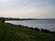
The shore looks directly upon Staten Island
's southern shore; the Verrazano-Narrows Bridge
, Lower Manhattan
including the Empire State Building
(on a clear night) and Brooklyn
can also be seen.
According to the United States Census Bureau
, the CDP has a total area of 7.5 km2 (2.9 mi2). 7.3 km2 (2.8 mi2) of it is land and 0.2 km2 (0.1 mi2) of it (2.08%) is water.
. This family had 645 acres (2.6 km²) here.
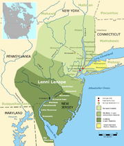 The lands known today as Laurence Harbor were part of the southernmost region inhabited by the Lenni Lenape
tribe (also known as the Delaware) in the 17th century. In 1664, they became part of greater East Jersey
, and in 1684 became part of a South Amboy
that was much larger than it is today. In 1869, Madison Township split off from South Amboy, becoming Old Bridge Township in 1975.
European settlement of the area was linked to commerce passing through the nearby Amboys
along the Raritan River
. From a military perspective, the area was useful for it high bayside cliffs, which allowed for strategic observation of ships traveling between New York Harbor
and the Atlantic Ocean
.
Laurence Harbor is named after land developer Laurence Lamb, who bought property in then-Madison Township at the turn of the 20th century and subdivided it into bungalow-sized lots. Lamb established a 400 acres (1.6 km²) shorefront golf and country club on the site. Among those who frequented Mr. Lamb's establishment were Clark Gable, Guy Lombardo, the Prince of Wales and the Vanderbilts, who came to party and eat chingarora oysters, for which Raritan Bay was then famous. In 1928, the golf club was sold to developers for the above mentioned construction of bungalows. A boardwalk, complete with a dance hall, casino, band shell, concession stands and a merry-go-round that played only one song, Let's Remember Pearl Harbor, provided entertainment, hot dogs and ice cream during the 1940s.
For those traveling south from North Jersey
or New York, it was the first stretch of Jersey Shore
beachfront before the then more popular Keansburg
or Asbury Park
.
According to a local historian who grew up in Old Bridge Township, the area was also used during Prohibition by rum runners who would lower their cargo of bootleg liquor overboard into the bay to be hauled ashore by local fishermen.
of 2000, there were 6,227 people, 2,286 households, and 1,634 families residing in the CDP. The population density
was 852.6/km2 (2,210.3/mi2). There were 2,362 housing units at an average density of 323.4/km2 (838.4/mi2). The racial makeup of the CDP was 90.65% White, 3.57% African American, 0.22% Native American, 2.20% Asian, 0.05% Pacific Islander, 1.64% from other races
, and 1.67% from two or more races. Hispanic or Latino of any race were 6.86% of the population.
There were 2,286 households out of which 34.4% had children under the age of 18 living with them, 55.6% were married couples
living together, 11.5% had a female householder with no husband present, and 28.5% were non-families. 22.7% of all households were made up of individuals and 4.9% had someone living alone who was 65 years of age or older. The average household size was 2.72 and the average family size was 3.25.
In the CDP the population was spread out with 25.6% under the age of 18, 7.4% from 18 to 24, 34.9% from 25 to 44, 24.5% from 45 to 64, and 7.5% who were 65 years of age or older. The median age was 36 years. For every 100 females there were 104.0 males. For every 100 females age 18 and over, there were 100.1 males.
The median income for a household in the CDP was $57,997, and the median income for a family was $61,470. Males had a median income of $46,439 versus $30,918 for females. The per capita income
for the CDP was $23,619. About 4.3% of families and 5.6% of the population were below the poverty line, including 7.2% of those under age 18 and 10.8% of those age 65 or over.
Many houses along the waterfront and off Route 35 are bungalow
style. As this area was considered a beach resort back in the 1920s-1950s, a majority of these houses were only intended for summer use only. Some still maintain their original look from the day they were built. Some even have no insulation in the walls as this was a "summer community".
.
and World War II
residue was dumped at the mouth of the Raritan River
in Perth/South Amboy.
In June of 2010, heavy equipment moved in and construction began on the beachfront next to the Old Bridge Township Police Sub-Station. The earthmoving was being done to address the serious beach erosion. Summer storms in 2004 eroded a protective sand dune. Behind that sand dune are approximately thirty homes which are below low tide sea level. Middlesex County has the primary responsibility for maintaining the Old Bridge Water Front Park. In early 2005 planning began to shore up the remaining part of the dunes. Prior efforts have had limited temporary affect. Storms during the spring of 2010 had a devastating effect on the previous work. Middlesex County procured a grant to pursue a different method whereby a casement would be created to stop the beach erosion and dunes would be created from heavier, courser material.
Under the sand, for the entire length of the Old Bridge Waterfront Park, sewer lines and water lines have served thousands of homes for decades. Continued erosion would jeopardize the integrity of the pipes.
Pollution issues are being addressed south of this area at the Laurence Harbor Beach at the end of Laurence Parkway. The Environmental Protection Agency has closed off the beach to the public. There is information on the site at their web site under the National Priorities List for Raritan Bay Slag Site. It is alleged that slag from the National Lead Refinery in Edison, NJ was dumped along the shore in the 1960s and the 1970s.
Census-designated place
A census-designated place is a concentration of population identified by the United States Census Bureau for statistical purposes. CDPs are delineated for each decennial census as the statistical counterparts of incorporated places such as cities, towns and villages...
and unincorporated area located on the Raritan Bay
Raritan Bay
Raritan Bay is a bay located at the southern portion of Lower New York Bay between the U.S. states of New York and New Jersey and is part of the New York Bight. The bay is bounded on the northwest by New York's Staten Island, on the west by Perth Amboy, New Jersey, on the south by the Raritan...
within Old Bridge Township
Old Bridge Township, New Jersey
Old Bridge Township is a Township in Middlesex County, New Jersey, United States. As of the 2000 United States Census, the township had a total population of 60,456...
, in Middlesex County
Middlesex County, New Jersey
-Demographics:As of the census of 2000, there were 750,162 people, 265,815 households, and 190,855 families residing in the county. The population density was 2,422 people per square mile . There were 273,637 housing units at an average density of 884 per square mile...
, New Jersey
New Jersey
New Jersey is a state in the Northeastern and Middle Atlantic regions of the United States. , its population was 8,791,894. It is bordered on the north and east by the state of New York, on the southeast and south by the Atlantic Ocean, on the west by Pennsylvania and on the southwest by Delaware...
. As of the 2000 United States Census, the CDP population was 6,227.
Geography
Garden State Parkway
The Garden State Parkway is a 172.4-mile limited-access toll parkway that stretches the length of New Jersey from the New York line at Montvale, New Jersey, to Cape May at New Jersey's southernmost tip. Its name refers to New Jersey's nickname, the "Garden State." Most New Jersey residents refer...
. The main routes through it include Laurence Parkway and Route 35. The railroad, which has no station in Laurence Harbor, divides the town into eastern and western sections, the former being locally referred to as 'The Front'. Cliffwood Beach also borders Laurence Harbor when traveling south.
The shore looks directly upon Staten Island
Staten Island
Staten Island is a borough of New York City, New York, United States, located in the southwest part of the city. Staten Island is separated from New Jersey by the Arthur Kill and the Kill Van Kull, and from the rest of New York by New York Bay...
's southern shore; the Verrazano-Narrows Bridge
Verrazano-Narrows Bridge
The Verrazano-Narrows Bridge is a double-decked suspension bridge that connects the boroughs of Staten Island and Brooklyn in New York City at the Narrows, the reach connecting the relatively protected upper bay with the larger lower bay....
, Lower Manhattan
Lower Manhattan
Lower Manhattan is the southernmost part of the island of Manhattan, the main island and center of business and government of the City of New York...
including the Empire State Building
Empire State Building
The Empire State Building is a 102-story landmark skyscraper and American cultural icon in New York City at the intersection of Fifth Avenue and West 34th Street. It has a roof height of 1,250 feet , and with its antenna spire included, it stands a total of 1,454 ft high. Its name is derived...
(on a clear night) and Brooklyn
Brooklyn
Brooklyn is the most populous of New York City's five boroughs, with nearly 2.6 million residents, and the second-largest in area. Since 1896, Brooklyn has had the same boundaries as Kings County, which is now the most populous county in New York State and the second-most densely populated...
can also be seen.
According to the United States Census Bureau
United States Census Bureau
The United States Census Bureau is the government agency that is responsible for the United States Census. It also gathers other national demographic and economic data...
, the CDP has a total area of 7.5 km2 (2.9 mi2). 7.3 km2 (2.8 mi2) of it is land and 0.2 km2 (0.1 mi2) of it (2.08%) is water.
Morgan
One mile northwest, across the Cheesequake Creek and the Morgan Bridge is Morgan. Named after the 1703 family and the cousins of the infamous Pirate Captain Henry MorganHenry Morgan
Admiral Sir Henry Morgan was an Admiral of the Royal Navy, a privateer, and a pirate who made a name for himself during activities in the Caribbean, primarily raiding Spanish settlements...
. This family had 645 acres (2.6 km²) here.
History
Lenape
The Lenape are an Algonquian group of Native Americans of the Northeastern Woodlands. They are also called Delaware Indians. As a result of the American Revolutionary War and later Indian removals from the eastern United States, today the main groups live in Canada, where they are enrolled in the...
tribe (also known as the Delaware) in the 17th century. In 1664, they became part of greater East Jersey
East Jersey
The Province of East Jersey and the Province of West Jersey were two distinct, separately governed parts of the Province of New Jersey that existed as separate provinces for 28 years, between 1674 and 1702. East Jersey's capital was located at Perth Amboy...
, and in 1684 became part of a South Amboy
South Amboy, New Jersey
South Amboy is a city in Middlesex County, New Jersey, on the Raritan Bay. As of the 2000 United States Census, the city population was 7,913.South Amboy, and Perth Amboy across the Raritan River, are collectively referred to as The Amboys...
that was much larger than it is today. In 1869, Madison Township split off from South Amboy, becoming Old Bridge Township in 1975.
European settlement of the area was linked to commerce passing through the nearby Amboys
The Amboys
The Amboys are a pair of municipalities in Middlesex County, New Jersey, both of which have the word Amboy in their name. The two municipalities are the City of Perth Amboy and the City of South Amboy, located across from each other on the Raritan Bay....
along the Raritan River
Raritan River
The Raritan River is a major river of central New Jersey in the United States. Its watershed drains much of the mountainous area of the central part of the state, emptying into the Raritan Bay on the Atlantic Ocean.-Description:...
. From a military perspective, the area was useful for it high bayside cliffs, which allowed for strategic observation of ships traveling between New York Harbor
New York Harbor
New York Harbor refers to the waterways of the estuary near the mouth of the Hudson River that empty into New York Bay. It is one of the largest natural harbors in the world. Although the U.S. Board of Geographic Names does not use the term, New York Harbor has important historical, governmental,...
and the Atlantic Ocean
Atlantic Ocean
The Atlantic Ocean is the second-largest of the world's oceanic divisions. With a total area of about , it covers approximately 20% of the Earth's surface and about 26% of its water surface area...
.
Laurence Harbor is named after land developer Laurence Lamb, who bought property in then-Madison Township at the turn of the 20th century and subdivided it into bungalow-sized lots. Lamb established a 400 acres (1.6 km²) shorefront golf and country club on the site. Among those who frequented Mr. Lamb's establishment were Clark Gable, Guy Lombardo, the Prince of Wales and the Vanderbilts, who came to party and eat chingarora oysters, for which Raritan Bay was then famous. In 1928, the golf club was sold to developers for the above mentioned construction of bungalows. A boardwalk, complete with a dance hall, casino, band shell, concession stands and a merry-go-round that played only one song, Let's Remember Pearl Harbor, provided entertainment, hot dogs and ice cream during the 1940s.
For those traveling south from North Jersey
North Jersey
North Jersey is a colloquial term, with no precise consensus definition, for the northern portion of the U.S. state of New Jersey. A straightforward, noncolloquial term for the region is northern New Jersey.- Two-portion approaches :...
or New York, it was the first stretch of Jersey Shore
Jersey Shore
The Jersey Shore is a term used to refer to both the Atlantic coast of the U.S. state of New Jersey and the adjacent resort and residential communities. . The New Jersey State Department of Tourism considers the Shore Region, Greater Atlantic City, and the Southern Shore to be distinct, each having...
beachfront before the then more popular Keansburg
Keansburg, New Jersey
Keansburg is a borough in Monmouth County, New Jersey, United States. As of the 2010 United States Census, the borough population was 10,105.Keansburg was formed as a borough by an act of the New Jersey Legislature on March 26, 1917, from portions of both Middletown Township and Raritan Township ,...
or Asbury Park
Asbury Park, New Jersey
Asbury Park is a city in Monmouth County, New Jersey, United States, located on the Jersey Shore and part of the New York City Metropolitan Area. As of the 2010 United States Census, the city population was 16,116. The city is known for its rich musical history, including its association with...
.
According to a local historian who grew up in Old Bridge Township, the area was also used during Prohibition by rum runners who would lower their cargo of bootleg liquor overboard into the bay to be hauled ashore by local fishermen.
Demographics
As of the censusCensus
A census is the procedure of systematically acquiring and recording information about the members of a given population. It is a regularly occurring and official count of a particular population. The term is used mostly in connection with national population and housing censuses; other common...
of 2000, there were 6,227 people, 2,286 households, and 1,634 families residing in the CDP. The population density
Population density
Population density is a measurement of population per unit area or unit volume. It is frequently applied to living organisms, and particularly to humans...
was 852.6/km2 (2,210.3/mi2). There were 2,362 housing units at an average density of 323.4/km2 (838.4/mi2). The racial makeup of the CDP was 90.65% White, 3.57% African American, 0.22% Native American, 2.20% Asian, 0.05% Pacific Islander, 1.64% from other races
Race (United States Census)
Race and ethnicity in the United States Census, as defined by the Federal Office of Management and Budget and the United States Census Bureau, are self-identification data items in which residents choose the race or races with which they most closely identify, and indicate whether or not they are...
, and 1.67% from two or more races. Hispanic or Latino of any race were 6.86% of the population.
There were 2,286 households out of which 34.4% had children under the age of 18 living with them, 55.6% were married couples
Marriage
Marriage is a social union or legal contract between people that creates kinship. It is an institution in which interpersonal relationships, usually intimate and sexual, are acknowledged in a variety of ways, depending on the culture or subculture in which it is found...
living together, 11.5% had a female householder with no husband present, and 28.5% were non-families. 22.7% of all households were made up of individuals and 4.9% had someone living alone who was 65 years of age or older. The average household size was 2.72 and the average family size was 3.25.
In the CDP the population was spread out with 25.6% under the age of 18, 7.4% from 18 to 24, 34.9% from 25 to 44, 24.5% from 45 to 64, and 7.5% who were 65 years of age or older. The median age was 36 years. For every 100 females there were 104.0 males. For every 100 females age 18 and over, there were 100.1 males.
The median income for a household in the CDP was $57,997, and the median income for a family was $61,470. Males had a median income of $46,439 versus $30,918 for females. The per capita income
Per capita income
Per capita income or income per person is a measure of mean income within an economic aggregate, such as a country or city. It is calculated by taking a measure of all sources of income in the aggregate and dividing it by the total population...
for the CDP was $23,619. About 4.3% of families and 5.6% of the population were below the poverty line, including 7.2% of those under age 18 and 10.8% of those age 65 or over.
Housing
Real estate in Laurence Harbor is inexpensive when compared to anywhere else around it in all three directions. It is still often considered a bit underclass because of its high working class and retiree population. In the 1990s, when "Bridgepointe," a community of 400 townhouses was constructed at the western end of Laurence Harbor near Exit 120 of the Garden State Parkway, the former "underclass" appearance changed attracting many higher income residents.Many houses along the waterfront and off Route 35 are bungalow
Bungalow
A bungalow is a type of house, with varying meanings across the world. Common features to many of these definitions include being detached, low-rise , and the use of verandahs...
style. As this area was considered a beach resort back in the 1920s-1950s, a majority of these houses were only intended for summer use only. Some still maintain their original look from the day they were built. Some even have no insulation in the walls as this was a "summer community".
Parks and recreation
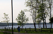
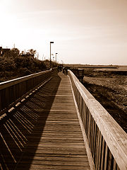
Laurence Harbor is home to Laurence Harbor Waterfront Park which consists of a new boardwalk (the old boardwalk was destroyed in the 1940-1950's) which was completed in 2002. It extends approximately one mile from the Old Bridge Police substation south, to the border of Cliffwood Beach, the Aberdeen portion and runs parallel with New Jersey Route 35. This area is very popular for fishing as three jetties extend into the Raritan and are in excellent condition, also recently redone in the past ten years. The Waterfront Park is very close to Cheesequake State ParkCheesequake State Park
Cheesequake State Park is a state park located in Old Bridge Township, Middlesex County, New Jersey in the United States.The New Jersey Legislature allocated $100,000 in 1937 to purchase property for this state park. The state first acquired a 250 acre tract of farmland and a Civil War era mansion...
.
Pollution
Pollution began in the area early. Water quality on the nearby marshes were already being damaged before the 1940s war era. The water table and health concerns only first became an issue in the early 1970s, a little late, but a beginning nonetheless. Water during the 1950s coming out of the tap was tinted orange and had a very heavy iron taste possibly copper. The petrochemical and paint industry were just miles away. The United States Government had an armory nearby and is responsible for tons of munitions waste nearby. World War IWorld War I
World War I , which was predominantly called the World War or the Great War from its occurrence until 1939, and the First World War or World War I thereafter, was a major war centred in Europe that began on 28 July 1914 and lasted until 11 November 1918...
and World War II
World War II
World War II, or the Second World War , was a global conflict lasting from 1939 to 1945, involving most of the world's nations—including all of the great powers—eventually forming two opposing military alliances: the Allies and the Axis...
residue was dumped at the mouth of the Raritan River
Raritan River
The Raritan River is a major river of central New Jersey in the United States. Its watershed drains much of the mountainous area of the central part of the state, emptying into the Raritan Bay on the Atlantic Ocean.-Description:...
in Perth/South Amboy.
In June of 2010, heavy equipment moved in and construction began on the beachfront next to the Old Bridge Township Police Sub-Station. The earthmoving was being done to address the serious beach erosion. Summer storms in 2004 eroded a protective sand dune. Behind that sand dune are approximately thirty homes which are below low tide sea level. Middlesex County has the primary responsibility for maintaining the Old Bridge Water Front Park. In early 2005 planning began to shore up the remaining part of the dunes. Prior efforts have had limited temporary affect. Storms during the spring of 2010 had a devastating effect on the previous work. Middlesex County procured a grant to pursue a different method whereby a casement would be created to stop the beach erosion and dunes would be created from heavier, courser material.
Under the sand, for the entire length of the Old Bridge Waterfront Park, sewer lines and water lines have served thousands of homes for decades. Continued erosion would jeopardize the integrity of the pipes.
Pollution issues are being addressed south of this area at the Laurence Harbor Beach at the end of Laurence Parkway. The Environmental Protection Agency has closed off the beach to the public. There is information on the site at their web site under the National Priorities List for Raritan Bay Slag Site. It is alleged that slag from the National Lead Refinery in Edison, NJ was dumped along the shore in the 1960s and the 1970s.