
.gif)
Route 29 (New Jersey)
Encyclopedia
Route 29 is a state highway
in the U.S. state
of New Jersey
. It runs 34.76 mi (55.94 km) from an intersection with Interstate 295 in Hamilton Township
in Mercer County
, where it continues as Interstate 195
, to Route 12 (Bridge Street / Race Street) in Frenchtown
, Hunterdon County
. Between the southern terminus and Interstate 95
, the route is a mix of freeway and four-lane divided highway
that runs along the Delaware River
through Trenton
. This section includes a truck-restricted tunnel that was built along the river near historic houses and Riverview Cemetery. North of Interstate 95, Route 29 turns into a scenic and mostly two-lane highway, and from the South Trenton Tunnel, is designated the Delaware River Scenic Byway, a National Scenic Byway
, that follows the Delaware River in mostly rural sections of Mercer County and Hunterdon County. The obsolete Delaware & Raritan Canal usually stands between the river and the highway. Most sections of this portion of Route 29 are completely shaded due to the tree canopy. Route 29 also has a spur, Route 129, which connects Route 29 to U.S. Route 1
in Trenton.
Route 29 was initially designated in 1927 to run from downtown Trenton
to Newark
, following present-day Route 179 and U.S. Route 202
between Lambertville
and Somerville
and U.S. Route 22
between Somerville and Newark. The route between Lambertville and Frenchtown
was originally Route 29A. In 1953, Route 29 was shifted to follow the alignment of Route 29A to avoid the concurrencies
with the U.S. Routes. Route 29 between South Warren Street in Trenton and Interstate 95 in Ewing Township was upgraded to a four-lane highway, with a portion of freeway, in the 1950s and 1960s. In 1995, the southern freeway part of Route 29 between Interstate 195/Interstate 295 and Route 129 in Hamilton Township was completed. This freeway section was linked to the rest of Route 29 by a tunnel completed in 2002. A realignment of Route 29 in Lambertville by the 2000s made the route concurrent with the entire length of 0.26 mi (0.4184284 km) long Route 165.
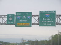 Route 29 begins at a modified cloverleaf interchange with Interstate 195
and Interstate 295
in Hamilton Township
, and it serves as the western continuation of Interstate 195, heading to the northwest as a six-lane freeway. The route interchanges with Route 129, a spur of Route 29 which connects to U.S. Route 1
, at a partial interchange with a northbound exit and southbound entrance. Route 29 narrows to four lanes past this interchange and crosses into Trenton
. The route comes to a southbound exit and entrance for Lamberton Road. At this point, Route 29 becomes the Delaware River Scenic Byway, a state scenic byway that was also designated a National Scenic Byway
in 2009. Route 29 runs along the bank of the Delaware River
and enters a truck-restricted tunnel
that passes by historic houses and Riverview Cemetery. Within this tunnel, Route 29 features a southbound exit and northbound entrance for Lalor Street. The route emerges from the tunnel as the John Fitch Parkway, passes by Mercer County Waterfront Park
, and comes to a traffic light at Thunder Road/Cass Street where it widens back to six lanes. Route 29 meets South Warren Street at another traffic light. The median widens and it passes under the Morrisville-Trenton Railroad Bridge
, which carries the Amtrak
Northeast Corridor
over the Delaware River.
 Route 29 passes under the Trenton-Morrisville Toll Bridge
, which carries U.S. Route 1
over the Delaware River. Access to U.S. Route 1 southbound is provided by ramps from Route 29 while access to Route 29 from northbound U.S. Route 1 is provided by South Warren Street. Route 29 passes under the Lower Trenton Bridge
and the median narrows again. It interchanges with Market Street, which provides access to Route 33, and then features an interchange which provides access to the New Jersey State House
with a northbound exit and southbound entrance. Route 29 crosses the Assunpink Creek
and features an interchange which provides access to South Warren Street with exits in both directions but only a northbound entrance. Route 29 continues to a cloverleaf interchange with Calhoun Street (County Route 653), which provides access to the Calhoun Street Bridge
over the Delaware River. Riverside Avenue exits as a frontage road
paralleling the northbound lanes of Route 29 before the road features a northbound exit for Hermitage Avenue. Route 29 comes to a partial interchange with Parkside Avenue, with a northbound exit and southbound entrance, and then features a northbound exit for South Eastfield Avenue.
The freeway portion of Route 29 ends at the intersection with Lee Avenue and it continues northwest along the Delaware River as a four-lane divided highway
. The route meets the southern terminus of County Route 579
(Sullivan Way). The median widens again and then narrows as the route meets the southern terminus of Route 175, a former alignment of Route 29 that currently serves as a frontage road. Route 29 crosses into Ewing Township
and becomes the Daniel Bray Highway. It passes under the West Trenton Railroad Bridge
, which carries CSX and SEPTA’s West Trenton Line
line over the Delaware River. Route 29 intersects Route 175 again and then comes to a complex interchange with Interstate 95
, with the ramps within the median of Route 29, just to the east of the Scudder Falls Bridge
.
Upon crossing the Delaware and Raritan Canal
, Route 29 narrows down to a two-lane undivided road called River Road. It continues along the Delaware River, next to the Delaware and Raritan Canal, which runs between Route 29 and the river. The route intersects the northern terminus of Route 175. Farther north, Route 29 enters Hopewell Township
and continues into a more rural setting shaded with trees. Route 29 heads to Washington's Crossing
, where it intersects County Route 546
, which heads east on Washington Crossing-Pennington Road, and the approach to the Washington Crossing Bridge
, which continues into Pennsylvania as Pennsylvania Route 532
. Route 29 continues north along the Delaware River through Titusville
, passing by Washington Crossing State Park
.
in Hunterdon County
. It enters Lambertville
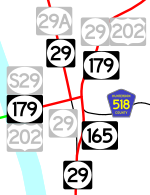
, where Route 29 becomes a four-lane divided highway. At the intersection of South Main Street, Route 29 becomes concurrent with Route 165. The route becomes an undivided highway again and meets the western terminus of County Route 518
(Brunswick Street). It meets Route 179 (Bridge Street), where Route 165 ends and Route 29 turns west for a one-block wrong-way concurrency with the two-lane, undivided Route 179, lasting to the intersection of Main Street, where Route 29 turns north on Main Street.
Route 29 follows Main Street north through Lambertville, crossing into Delaware Township
. It comes to an interchange with U.S. Route 202
just east of the New Hope-Lambertville Toll Bridge
, with access to northbound U.S. Route 202 and from southbound U.S. Route 202 provided by way of Alexauken Creek Road. Route 29 continues along the Delaware River and enters Stockton
. The route intersects Bridge Street, which crosses the Delaware River on the Centre Bridge-Stockton Bridge
and continues into Pennsylvania as Pennsylvania Route 263
. Shortly after that intersection, Route 29 intersects the southern terminus of County Route 523
(Stockton-Flemington Road). Route 29 crosses back into Delaware Township, where it meets the southern terminus of County Route 519
(Kingwood-Stockton Road).
Route 29 makes a sharp left turn and heads west along the river as a rural road, crossing into Kingwood Township
, where the name of the road changes from Main Street to Daniel Bray Highway. Here, it intersects with County Route 651 (Byram-Kingwood Road). The route bends to the north and continues along the Delaware River for several miles, crossing into Frenchtown
, where the route becomes Trenton Road. Upon entering Frenchtown, an end shield for northbound Route 29 is posted to mark the end of state maintenance, which officially ends at the Washington Street intersection, where maintenance is transferred to the county. Despite this, Route 29 officially continues farther north along Trenton Road to its northern terminus at Route 12 (Bridge Street/Race Street), a short distance east of Route 12’s western terminus at the Uhlerstown-Frenchtown Bridge. The southern terminus of County Route 513
is located a block north of the northern terminus of Route 29 along Route 12.
 The current route was originally legislated in 1911 as part of the Delaware River Drive
, a named state highway that was proposed to run from along the Delaware River from Trenton to the New York
border in Montague Township
. Route 29 was originally defined in 1927 to run from Trenton
to Newark
. The original route ran from downtown Trenton along State Street and Sanhican Drive. From there, it followed its current alignment to Lambertville
, where it followed present-day Route 179 to Ringoes
to present-day County Route 514
, which it followed to Woods Tavern. The route turned north on U.S. Route 206
(also designated Route 31) and followed that route to Somerville
, where it followed U.S. Route 22
to Newark. The current alignment of Route 29 from Lambertville
to Route 12 in Frenchtown
was designated Route 29A in 1927.
The alignment of Route 29 between Ringoes and Somerville was eventually shifted to follow present-day U.S. Route 202
, which was also Route 30 (now Route 31) between Ringoes and Flemington
and Route 12 between Flemington and Somerville. In 1938, Route 29B was planned as an extension of Route 29A from Frenchtown
to Route 28 (now Route 122) in Alpha
. While this road was never built, much of the alignment north of Milford
is served by County Route 519
. In 1948, a spur route, Route S29, was created, running along U.S. Route 202 (Bridge Street) in Lambertville to the New Hope-Lambertville Bridge
.
In the 1953 New Jersey state highway renumbering
, Route 29 was redefined to continue north from Lambertville to Frenchtown on Route 29A, and the Route 29 designation between Lambertville and Newark was removed in favor of U.S. Route 202
between Lambertville and Somerville and U.S. Route 22
between Somerville and Newark. The section of former Route 29 between Route 29A and Route S29 became Route 165.
Plans for a limited-access route along the Route 29 corridor go back to 1932, when a parkway
was proposed along the Delaware River
between Trenton and Lambertville; this proposal never materialized. Plans for a freeway were resurrected in the early 1950s to construct a road, the John Fitch Parkway, that was to run from Hamilton Township
to Interstate 95
in Ewing Township
. This road was built between 1954 and 1957 from South Warren Street in Trenton to present-day Interstate 95 in Ewing Township. Construction of this portion John Fitch Parkway took up much of Trenton’s available waterfront along the Delaware River. The former alignment of Route 29 in the northern part of Trenton and in Ewing Township became Route 175.
Between 1990 and 1995, the Route 29 freeway was built between the Interstate 195
/Interstate 295
interchange and Route 129 in Hamilton Township. A two-lane street, Lamberton Road, connected the two freeway sections. Plans were then made to fill the gap between the two freeway sections in Trenton. Construction began in 1997 on the Route 29 freeway between Route 129 and the Morrisville-Trenton Railroad Bridge
. The road was to include two traffic lights at Cass Street and South Warren Street and a tunnel which was to be built as a covered roadway on the bank of the Delaware River. The tunnel was originally scheduled to be complete by 2001 but was delayed after the Army Corps of Engineers discovered many environmental violations that occurred with construction of the tunnel. The roof was put in place in October 2001 and the tunnel officially opened to traffic on March 2, 2002. A restriction to trucks over 13 tons was put in place and made permanent in November 2002. In 2003, construction of a waterfront park above the Route 29 tunnel was completed, rendering access to the Delaware River waterfront for the southern part of Trenton.
By the 2000s, the state gave the part of Route 29 (South Main Street) between Route 165 and Route 179 in Lambertville
to the city, and Route 29 was rerouted to use all of Route 165 and one block of Route 179. Prior to this, South Main Street had been turned one-way southbound. Route 165, which is only signed on overhead street signs, still exists, though it is fully concurrent with Route 29.
!County
!Location
!Mile
!Destinations
!Notes
|-
|rowspan=20|Mercer
|rowspan=3|Hamilton Township
|0.00
|
|Southern terminus; Continues as I-195; I-295 exit 60
|-
|rowspan=2|1.64
|
|rowspan=2|Northbound exit
|-
|S. Lamberton Road – Duck Island
|-
|rowspan=13|Trenton
|1.77
|S. Lamberton Road – Duck Island
|Southbound exit
|-
|2.56
|
|
|-
|3.37
| – Morrisville
|
|-
|3.63
|
|
|-
|3.84
|Memorial Drive – Capitol Complex
|
|-
|4.34
|, Morrisville
|
|-
|4.81
|Riverside Avenue
|Northbound exit
|-
|5.01
|Hermitage Avenue
|Northbound exit
|-
|5.45
|Parkside Avenue – Cadwalder Park
|Northbound exit
|-
|5.60
|S. Eastfield Avenue
|Northbound exit
|-
|colspan=5 align="center"|North end of freeway
|-
|6.18
|
|
|-
|6.74
|
|
|-
|rowspan=3|Ewing Township
|8.49
|
|
|-
|9.13
|
|Interchange; I-95 exit 1
|-
|9.55
|
|
|-
|Hopewell Township
|11.95
|
|
|-
|rowspan=8|Hunterdon
|rowspan=4|Lambertville
|18.60
|
|South end of NJ 165 overlap
|-
|18.77
|
|
|-
|18.87
|
|North end of NJ 165 overlap, south end of NJ 179 overlap
|-
|18.89
|
|North end of NJ 179 overlap
|-
|Delaware Township
|20.06
|
|Interchange
|-
|Stockton
|22.48
|
|
|-
|Delaware Township
|23.03
|
|
|-
|Frenchtown
|34.71
|
|Northern terminus
|-
State highway
State highway, state road or state route can refer to one of three related concepts, two of them related to a state or provincial government in a country that is divided into states or provinces :#A...
in the U.S. state
U.S. state
A U.S. state is any one of the 50 federated states of the United States of America that share sovereignty with the federal government. Because of this shared sovereignty, an American is a citizen both of the federal entity and of his or her state of domicile. Four states use the official title of...
of New Jersey
New Jersey
New Jersey is a state in the Northeastern and Middle Atlantic regions of the United States. , its population was 8,791,894. It is bordered on the north and east by the state of New York, on the southeast and south by the Atlantic Ocean, on the west by Pennsylvania and on the southwest by Delaware...
. It runs 34.76 mi (55.94 km) from an intersection with Interstate 295 in Hamilton Township
Hamilton Township, Mercer County, New Jersey
Hamilton Township is a Township in Mercer County, New Jersey, United States. As of the United States 2010 Census, the township had a total population of 88,464...
in Mercer County
Mercer County, New Jersey
As of the census of 2000, there were 350,761 people, 125,807 households, and 86,303 families residing in the county. The population density was 1,552 people per square mile . There were 133,280 housing units at an average density of 590 per square mile...
, where it continues as Interstate 195
Interstate 195 (New Jersey)
Interstate 195 is an auxiliary route of the Interstate Highway System located in the U.S. state of New Jersey. Its western end is at I-295 and Route 29 just south of Trenton, New Jersey in Hamilton Township, Mercer County while its eastern end is at the Garden State Parkway, Route 34 and Route...
, to Route 12 (Bridge Street / Race Street) in Frenchtown
Frenchtown, New Jersey
Frenchtown is a Borough in Hunterdon County, New Jersey, United States. As of the United States 2010 Census, the borough population was 1,373....
, Hunterdon County
Hunterdon County, New Jersey
Hunterdon County is a county located in the western section of the U.S. state of New Jersey. As of the 2010 United States Census, the population was 128,349. It is part of the New York Metropolitan Area. Its county seat is Flemington....
. Between the southern terminus and Interstate 95
Interstate 95 in New Jersey
Interstate 95 is a major Interstate Highway that traverses the full extent of the East Coast of the United States, from Florida to Maine...
, the route is a mix of freeway and four-lane divided highway
Divided Highway
Divided Highway is a compilation album by American rock band The Doobie Brothers, released in 2003. . All tracks are taken from the albums Cycles and Brotherhood .-Track listing:...
that runs along the Delaware River
Delaware River
The Delaware River is a major river on the Atlantic coast of the United States.A Dutch expedition led by Henry Hudson in 1609 first mapped the river. The river was christened the South River in the New Netherland colony that followed, in contrast to the North River, as the Hudson River was then...
through Trenton
Trenton, New Jersey
Trenton is the capital of the U.S. state of New Jersey and the county seat of Mercer County. As of the 2010 United States Census, Trenton had a population of 84,913...
. This section includes a truck-restricted tunnel that was built along the river near historic houses and Riverview Cemetery. North of Interstate 95, Route 29 turns into a scenic and mostly two-lane highway, and from the South Trenton Tunnel, is designated the Delaware River Scenic Byway, a National Scenic Byway
National Scenic Byway
A National Scenic Byway is a road recognized by the United States Department of Transportation for its archeological, cultural, historic, natural, recreational, and/or scenic qualities. The program was established by Congress in 1991 to preserve and protect the nation's scenic but often...
, that follows the Delaware River in mostly rural sections of Mercer County and Hunterdon County. The obsolete Delaware & Raritan Canal usually stands between the river and the highway. Most sections of this portion of Route 29 are completely shaded due to the tree canopy. Route 29 also has a spur, Route 129, which connects Route 29 to U.S. Route 1
U.S. Route 1 in New Jersey
U.S. Route 1 is a United States highway which parallels the East Coast of the United States, running from Key West, Florida in the south to Fort Kent, Maine at the Canadian border in the north. Of the entire length of the route, of it runs through New Jersey...
in Trenton.
Route 29 was initially designated in 1927 to run from downtown Trenton
Trenton, New Jersey
Trenton is the capital of the U.S. state of New Jersey and the county seat of Mercer County. As of the 2010 United States Census, Trenton had a population of 84,913...
to Newark
Newark, New Jersey
Newark is the largest city in the American state of New Jersey, and the seat of Essex County. As of the 2010 United States Census, Newark had a population of 277,140, maintaining its status as the largest municipality in New Jersey. It is the 68th largest city in the U.S...
, following present-day Route 179 and U.S. Route 202
U.S. Route 202 in New Jersey
U.S. Route 202 is a U.S. Highway running from New Castle, Delaware northeast to Bangor, Maine. In the U.S. state of New Jersey, the route runs from the New Hope-Lambertville Toll Bridge over the Delaware River at the Pennsylvania border in Delaware Township, Hunterdon County near Lambertville...
between Lambertville
Lambertville, New Jersey
Lambertville is a city in Hunterdon County, New Jersey, United States. As of the 2010 United States Census, the city population was 3,906.Lambertville was originally incorporated as a town by an Act of the New Jersey Legislature on March 1, 1849, from portions of West Amwell Township...
and Somerville
Somerville, New Jersey
Somerville is a borough in Somerset County, New Jersey, United States. As of the 2010 United States Census, the borough population was 12,098. It is the county seat of Somerset County....
and U.S. Route 22
U.S. Route 22 in New Jersey
U.S. Route 22 is a U.S. highway stretching from Cincinnati, Ohio in the west to Newark, New Jersey in the east. In New Jersey, the route runs for from the Easton-Phillipsburg Toll Bridge over the Delaware River in Phillipsburg, Warren County to Interstate 78 , US 1/9, and Route 21 at the Newark...
between Somerville and Newark. The route between Lambertville and Frenchtown
Frenchtown, New Jersey
Frenchtown is a Borough in Hunterdon County, New Jersey, United States. As of the United States 2010 Census, the borough population was 1,373....
was originally Route 29A. In 1953, Route 29 was shifted to follow the alignment of Route 29A to avoid the concurrencies
Concurrency (road)
A concurrency, overlap, or coincidence in a road network is an instance of one physical road bearing two or more different highway, motorway, or other route numbers...
with the U.S. Routes. Route 29 between South Warren Street in Trenton and Interstate 95 in Ewing Township was upgraded to a four-lane highway, with a portion of freeway, in the 1950s and 1960s. In 1995, the southern freeway part of Route 29 between Interstate 195/Interstate 295 and Route 129 in Hamilton Township was completed. This freeway section was linked to the rest of Route 29 by a tunnel completed in 2002. A realignment of Route 29 in Lambertville by the 2000s made the route concurrent with the entire length of 0.26 mi (0.4184284 km) long Route 165.
Mercer County
Interstate 195 (New Jersey)
Interstate 195 is an auxiliary route of the Interstate Highway System located in the U.S. state of New Jersey. Its western end is at I-295 and Route 29 just south of Trenton, New Jersey in Hamilton Township, Mercer County while its eastern end is at the Garden State Parkway, Route 34 and Route...
and Interstate 295
Interstate 295 (Delaware-New Jersey)
Interstate 295 in New Jersey and Delaware is an auxiliary Interstate Highway, designated as a bypass around Philadelphia, Pennsylvania. The route begins at a junction with Interstate 95 south of Wilmington, Delaware, and runs to another junction with I-95 north of Trenton, New Jersey...
in Hamilton Township
Hamilton Township, Mercer County, New Jersey
Hamilton Township is a Township in Mercer County, New Jersey, United States. As of the United States 2010 Census, the township had a total population of 88,464...
, and it serves as the western continuation of Interstate 195, heading to the northwest as a six-lane freeway. The route interchanges with Route 129, a spur of Route 29 which connects to U.S. Route 1
U.S. Route 1 in New Jersey
U.S. Route 1 is a United States highway which parallels the East Coast of the United States, running from Key West, Florida in the south to Fort Kent, Maine at the Canadian border in the north. Of the entire length of the route, of it runs through New Jersey...
, at a partial interchange with a northbound exit and southbound entrance. Route 29 narrows to four lanes past this interchange and crosses into Trenton
Trenton, New Jersey
Trenton is the capital of the U.S. state of New Jersey and the county seat of Mercer County. As of the 2010 United States Census, Trenton had a population of 84,913...
. The route comes to a southbound exit and entrance for Lamberton Road. At this point, Route 29 becomes the Delaware River Scenic Byway, a state scenic byway that was also designated a National Scenic Byway
National Scenic Byway
A National Scenic Byway is a road recognized by the United States Department of Transportation for its archeological, cultural, historic, natural, recreational, and/or scenic qualities. The program was established by Congress in 1991 to preserve and protect the nation's scenic but often...
in 2009. Route 29 runs along the bank of the Delaware River
Delaware River
The Delaware River is a major river on the Atlantic coast of the United States.A Dutch expedition led by Henry Hudson in 1609 first mapped the river. The river was christened the South River in the New Netherland colony that followed, in contrast to the North River, as the Hudson River was then...
and enters a truck-restricted tunnel
Tunnel
A tunnel is an underground passageway, completely enclosed except for openings for egress, commonly at each end.A tunnel may be for foot or vehicular road traffic, for rail traffic, or for a canal. Some tunnels are aqueducts to supply water for consumption or for hydroelectric stations or are sewers...
that passes by historic houses and Riverview Cemetery. Within this tunnel, Route 29 features a southbound exit and northbound entrance for Lalor Street. The route emerges from the tunnel as the John Fitch Parkway, passes by Mercer County Waterfront Park
Mercer County Waterfront Park
Samuel J. Plumeri, Sr. Field at Mercer County Waterfront Park is a stadium in Trenton, New Jersey. It is the home baseball park for the Trenton Thunder of the Eastern League...
, and comes to a traffic light at Thunder Road/Cass Street where it widens back to six lanes. Route 29 meets South Warren Street at another traffic light. The median widens and it passes under the Morrisville-Trenton Railroad Bridge
Morrisville-Trenton Railroad Bridge
The Morrisville–Trenton Railroad Bridge carries the Amtrak Northeast Corridor, SEPTA Trenton Line and empty trains for NJ Transit's Northeast Corridor rail lines across the Delaware River between Morrisville, Pennsylvania and Trenton, New Jersey.-History:...
, which carries the Amtrak
Amtrak
The National Railroad Passenger Corporation, doing business as Amtrak , is a government-owned corporation that was organized on May 1, 1971, to provide intercity passenger train service in the United States. "Amtrak" is a portmanteau of the words "America" and "track". It is headquartered at Union...
Northeast Corridor
Northeast Corridor
The Northeast Corridor is a fully electrified railway line owned primarily by Amtrak serving the Northeast megalopolis of the United States from Boston in the north, via New York to Washington, D.C. in the south, with branches serving other cities...
over the Delaware River.
Trenton-Morrisville Toll Bridge
The Trenton–Morrisville Toll Bridge is one of three road bridges connecting Trenton, New Jersey with Morrisville, Pennsylvania. Opened in 1952, it carries U.S. Route 1 and is owned and operated by the Delaware River Joint Toll Bridge Commission. This bridge's toll plaza was originally configured to...
, which carries U.S. Route 1
U.S. Route 1 in New Jersey
U.S. Route 1 is a United States highway which parallels the East Coast of the United States, running from Key West, Florida in the south to Fort Kent, Maine at the Canadian border in the north. Of the entire length of the route, of it runs through New Jersey...
over the Delaware River. Access to U.S. Route 1 southbound is provided by ramps from Route 29 while access to Route 29 from northbound U.S. Route 1 is provided by South Warren Street. Route 29 passes under the Lower Trenton Bridge
Lower Trenton Bridge
The Lower Trenton Toll Supported Bridge, commonly called the Lower Free Bridge, Warren Street Bridge or Trenton Makes Bridge, is a two-lane through truss bridge over the Delaware River between Trenton, New Jersey and Morrisville, Pennsylvania, owned by the Delaware River Joint Toll Bridge Commission...
and the median narrows again. It interchanges with Market Street, which provides access to Route 33, and then features an interchange which provides access to the New Jersey State House
New Jersey State House
The New Jersey State House is located in Trenton and is the house of government for the U.S. state of New Jersey. After the Maryland State Capitol in Annapolis, it is the second oldest state house in continuous legislative use in the United States...
with a northbound exit and southbound entrance. Route 29 crosses the Assunpink Creek
Assunpink Creek
Assunpink Creek is a tributary of the Delaware River in western New Jersey in the United States.Assunpink Creek is born in rural Monmouth County, about a mile north of Clarksburg. Flowing westwards, it soon enters the Assunpink Wildlife Management Area, where it has been dammed to form Rising Sun...
and features an interchange which provides access to South Warren Street with exits in both directions but only a northbound entrance. Route 29 continues to a cloverleaf interchange with Calhoun Street (County Route 653), which provides access to the Calhoun Street Bridge
Calhoun Street Bridge (Trenton)
The Calhoun Street Toll Supported Bridge is a historic bridge connecting Calhoun Street in Trenton, New Jersey across the Delaware River to East Trenton Avenue in Morrisville, Pennsylvania. It was constructed by the Phoenix Bridge Company of Phoenixville, Pennsylvania in 1884...
over the Delaware River. Riverside Avenue exits as a frontage road
Frontage road
A frontage road is a non-limited access road running parallel to a higher-speed road, usually a freeway, and feeding it at appropriate points of access...
paralleling the northbound lanes of Route 29 before the road features a northbound exit for Hermitage Avenue. Route 29 comes to a partial interchange with Parkside Avenue, with a northbound exit and southbound entrance, and then features a northbound exit for South Eastfield Avenue.
The freeway portion of Route 29 ends at the intersection with Lee Avenue and it continues northwest along the Delaware River as a four-lane divided highway
Divided Highway
Divided Highway is a compilation album by American rock band The Doobie Brothers, released in 2003. . All tracks are taken from the albums Cycles and Brotherhood .-Track listing:...
. The route meets the southern terminus of County Route 579
County Route 579 (New Jersey)
County Route 579, abbreviated CR 579, is a county highway in the U.S. state of New Jersey. The highway extends from John Fitch Parkway in Trenton to Route 173 in Greenwich Township.-Mercer County:...
(Sullivan Way). The median widens again and then narrows as the route meets the southern terminus of Route 175, a former alignment of Route 29 that currently serves as a frontage road. Route 29 crosses into Ewing Township
Ewing Township, New Jersey
-Demographics:As of the 2010 Census, there were 35,790 people, 13,171 households, and 7,980 families residing in the township. There were 13,926 housing units. The racial makeup of the township was 63.1% White, 27.6% African American, 0.3% Native American, 4.3% Asian, 0.0% Pacific Islander, 2.2%...
and becomes the Daniel Bray Highway. It passes under the West Trenton Railroad Bridge
West Trenton Railroad Bridge
The West Trenton Railroad Bridge is a concrete arch bridge carrying the CSX and SEPTA West Trenton rail lines across the Delaware River between Yardley, Pennsylvania and Ewing Township, New Jersey. It was originally designed by the Philadelphia and Reading Railroad and was constructed from 1911 -...
, which carries CSX and SEPTA’s West Trenton Line
West Trenton Line (SEPTA)
The West Trenton Line is a SEPTA Regional Rail line connecting Center City Philadelphia to West Trenton, New Jersey.-Route:The West Trenton Line connects Center City, Philadelphia with the West Trenton section of Ewing, New Jersey...
line over the Delaware River. Route 29 intersects Route 175 again and then comes to a complex interchange with Interstate 95
Interstate 95 in New Jersey
Interstate 95 is a major Interstate Highway that traverses the full extent of the East Coast of the United States, from Florida to Maine...
, with the ramps within the median of Route 29, just to the east of the Scudder Falls Bridge
Scudder Falls Bridge
The Scudder Falls Bridge is a girder bridge that carries Interstate 95 over the Delaware River, connecting Lower Makefield Township in Bucks County, Pennsylvania with Ewing Township in Mercer County, New Jersey. This bridge, which was constructed from 1958 to 1959, is maintained by the Delaware...
.
Upon crossing the Delaware and Raritan Canal
Delaware and Raritan Canal
The Delaware and Raritan Canal is a canal in central New Jersey, United States, built in the 1830s that served to connect the Delaware River to the Raritan River. It was intended as an efficient and reliable means of transportation of freight between Philadelphia, Pennsylvania and New York City,...
, Route 29 narrows down to a two-lane undivided road called River Road. It continues along the Delaware River, next to the Delaware and Raritan Canal, which runs between Route 29 and the river. The route intersects the northern terminus of Route 175. Farther north, Route 29 enters Hopewell Township
Hopewell Township, Mercer County, New Jersey
As of the 2010 United States Census, the township's population was 17,304. The racial makeup of the township was 86.7% White, 2.1% African American, 0.1% Native American, 8.9% Asian, 0.0% Pacific Islander, 0.5% from other races, and 1.7% from two or more races...
and continues into a more rural setting shaded with trees. Route 29 heads to Washington's Crossing
Washington's Crossing
Washington's Crossing is a Pulitzer Prize winning book written by David Hackett Fischer and part of the "Pivotal Moments in American History" series...
, where it intersects County Route 546
County Route 546 (New Jersey)
County Route 546, abbreviated CR 546, is a county highway in the U.S. state of New Jersey. The highway begins at the Washington Crossing Bridge at Titusville, New Jersey and extends from Route 29 in Hopewell Township to U.S...
, which heads east on Washington Crossing-Pennington Road, and the approach to the Washington Crossing Bridge
Washington Crossing Bridge
Washington Crossing Bridge is a truss bridge spanning the Delaware River that connects Titusville, Hopewell Township in Mercer County, New Jersey with Washington Crossing, Upper Makefield Township in Bucks County, Pennsylvania. It was built in 1904 by the Taylorsville Delaware Bridge Company...
, which continues into Pennsylvania as Pennsylvania Route 532
Pennsylvania Route 532
Pennsylvania Route 532 is a state route located in the Philadelphia, Pennsylvania area.-Philadelphia:PA 532 begins as Welsh Road, where it intersects with Roosevelt Boulevard in Northeast Philadelphia. After less than a mile, PA 532 leaves Welsh Road and follows Bustleton Avenue...
. Route 29 continues north along the Delaware River through Titusville
Titusville, New Jersey
Titusville is an unincorporated area located within Hopewell Township, in Mercer County, New Jersey, United States. The area includes a post office with its own ZIP code , a small village of homes, and a large park dedicated to George Washington's crossing of the Delaware River in...
, passing by Washington Crossing State Park
Washington Crossing State Park
Washington Crossing State Park is a state park in the U.S. state of New Jersey that is part of Washington's Crossing, a U.S. National Historic Landmark area. It is located in the Titusville section of Hopewell Township in Mercer County, north of Trenton along the Delaware River...
.
Hunterdon County
Route 29 crosses into West Amwell TownshipWest Amwell Township, New Jersey
The Delaware River separates West Amwell from the Commonwealth of Pennsylvania.-Demographics:As of the census of 2000, there were 2,383 people, 949 households, and 696 families residing in the township. The population density was 109.7 people per square mile . There were 984 housing units at an...
in Hunterdon County
Hunterdon County, New Jersey
Hunterdon County is a county located in the western section of the U.S. state of New Jersey. As of the 2010 United States Census, the population was 128,349. It is part of the New York Metropolitan Area. Its county seat is Flemington....
. It enters Lambertville
Lambertville, New Jersey
Lambertville is a city in Hunterdon County, New Jersey, United States. As of the 2010 United States Census, the city population was 3,906.Lambertville was originally incorporated as a town by an Act of the New Jersey Legislature on March 1, 1849, from portions of West Amwell Township...
, where Route 29 becomes a four-lane divided highway. At the intersection of South Main Street, Route 29 becomes concurrent with Route 165. The route becomes an undivided highway again and meets the western terminus of County Route 518
County Route 518 (New Jersey)
County Route 518 is a county highway in the U.S. state of New Jersey. The highway extends from Route 165 in Lambertville to Lincoln Highway in Franklin Township...
(Brunswick Street). It meets Route 179 (Bridge Street), where Route 165 ends and Route 29 turns west for a one-block wrong-way concurrency with the two-lane, undivided Route 179, lasting to the intersection of Main Street, where Route 29 turns north on Main Street.
Route 29 follows Main Street north through Lambertville, crossing into Delaware Township
Delaware Township, Hunterdon County, New Jersey
-Demographics:As of the census of 2000, there were 4,478 people, 1,643 households, and 1,302 families residing in the township. The population density was 121.9 people per square mile . There were 1,701 housing units at an average density of 46.3 per square mile...
. It comes to an interchange with U.S. Route 202
U.S. Route 202 in New Jersey
U.S. Route 202 is a U.S. Highway running from New Castle, Delaware northeast to Bangor, Maine. In the U.S. state of New Jersey, the route runs from the New Hope-Lambertville Toll Bridge over the Delaware River at the Pennsylvania border in Delaware Township, Hunterdon County near Lambertville...
just east of the New Hope-Lambertville Toll Bridge
New Hope-Lambertville Toll Bridge
The New Hope-Lambertville Toll Bridge carries U.S. Route 202 over the Delaware River, connecting Delaware Township in Hunterdon County with Solebury Township in Bucks County. The bridge, which opened in 1971, was built and is currently operated by the Delaware River Joint Toll Bridge Commission...
, with access to northbound U.S. Route 202 and from southbound U.S. Route 202 provided by way of Alexauken Creek Road. Route 29 continues along the Delaware River and enters Stockton
Stockton, New Jersey
Stockton is a Borough in Hunterdon County, New Jersey, United States. The borough sits on the Delaware River at the western end of Amwell Valley...
. The route intersects Bridge Street, which crosses the Delaware River on the Centre Bridge-Stockton Bridge
Centre Bridge-Stockton Bridge
The Centre Bridge–Stockton Bridge is a free bridge over the Delaware River owned and operated by the Delaware River Joint Toll Bridge Commission...
and continues into Pennsylvania as Pennsylvania Route 263
Pennsylvania Route 263
Pennsylvania Route 263 is a north–south state highway located in southeast Pennsylvania. The southern terminus of the route is at PA 611 in Willow Grove, Montgomery County. The northern terminus is at PA 32 in Centre Bridge, Bucks County on the banks of the Delaware River near the Centre...
. Shortly after that intersection, Route 29 intersects the southern terminus of County Route 523
County Route 523 (New Jersey)
County Route 523 is a county highway in the U.S. state of New Jersey. The highway extends from Main Street in Stockton to Hillside Avenue in Bedminster Township.-Hunterdon County:...
(Stockton-Flemington Road). Route 29 crosses back into Delaware Township, where it meets the southern terminus of County Route 519
County Route 519 (New Jersey)
County Route 519 is a county highway in the U.S. state of New Jersey. The highway extends from Daniel Bray Highway in Delaware Township to the New York state line in Wantage Township...
(Kingwood-Stockton Road).
Route 29 makes a sharp left turn and heads west along the river as a rural road, crossing into Kingwood Township
Kingwood Township, New Jersey
- History :Kingwood Township is famous for the local captain who rounded up the boats for George Washington's crossing of the Delaware River during the American Revolutionary War.-Demographics:...
, where the name of the road changes from Main Street to Daniel Bray Highway. Here, it intersects with County Route 651 (Byram-Kingwood Road). The route bends to the north and continues along the Delaware River for several miles, crossing into Frenchtown
Frenchtown, New Jersey
Frenchtown is a Borough in Hunterdon County, New Jersey, United States. As of the United States 2010 Census, the borough population was 1,373....
, where the route becomes Trenton Road. Upon entering Frenchtown, an end shield for northbound Route 29 is posted to mark the end of state maintenance, which officially ends at the Washington Street intersection, where maintenance is transferred to the county. Despite this, Route 29 officially continues farther north along Trenton Road to its northern terminus at Route 12 (Bridge Street/Race Street), a short distance east of Route 12’s western terminus at the Uhlerstown-Frenchtown Bridge. The southern terminus of County Route 513
County Route 513 (New Jersey)
County Route 513 is a county highway in the U.S. state of New Jersey. The highway extends from Kingwood Avenue in Frenchtown to Lakeside Road in West Milford...
is located a block north of the northern terminus of Route 29 along Route 12.
History
Delaware River Drive
-Route description:A 1913 map of the proposed New Jersey State Highway System with an accompanying report shows the route of the Delaware River Drive beginning at the State Capitol on West State Street in Trenton...
, a named state highway that was proposed to run from along the Delaware River from Trenton to the New York
New York
New York is a state in the Northeastern region of the United States. It is the nation's third most populous state. New York is bordered by New Jersey and Pennsylvania to the south, and by Connecticut, Massachusetts and Vermont to the east...
border in Montague Township
Montague Township, New Jersey
-Transportation:One U.S., state, and county route traverse the township. U.S. Route 206 passes through in the western part and crosses the Delaware River at the Milford-Montague Toll Bridge. Route 23 passes through the eastern part and serves as the entrance road to High Point State Park and ends...
. Route 29 was originally defined in 1927 to run from Trenton
Trenton, New Jersey
Trenton is the capital of the U.S. state of New Jersey and the county seat of Mercer County. As of the 2010 United States Census, Trenton had a population of 84,913...
to Newark
Newark, New Jersey
Newark is the largest city in the American state of New Jersey, and the seat of Essex County. As of the 2010 United States Census, Newark had a population of 277,140, maintaining its status as the largest municipality in New Jersey. It is the 68th largest city in the U.S...
. The original route ran from downtown Trenton along State Street and Sanhican Drive. From there, it followed its current alignment to Lambertville
Lambertville, New Jersey
Lambertville is a city in Hunterdon County, New Jersey, United States. As of the 2010 United States Census, the city population was 3,906.Lambertville was originally incorporated as a town by an Act of the New Jersey Legislature on March 1, 1849, from portions of West Amwell Township...
, where it followed present-day Route 179 to Ringoes
Ringoes, New Jersey
Ringoes is an unincorporated area located within East Amwell Township, in Hunterdon County, New Jersey. The community is served by the United States Postal Service as ZIP Code 08551. As of the United States 2000 Census, the population for ZIP Code Tabulation Area 08551 was 5,082.-History:Ringoes is...
to present-day County Route 514
County Route 514 (New Jersey)
County Route 514 is a county highway in the U.S. state of New Jersey. The highway extends from US 202 in East Amwell Township to Bayway Avenue in Elizabeth...
, which it followed to Woods Tavern. The route turned north on U.S. Route 206
U.S. Route 206
U.S. Route 206 is a long north–south United States highway in New Jersey and Pennsylvania, United States. Only about a half a mile of its length is in Pennsylvania; the Milford-Montague Toll Bridge carries it over the Delaware River into New Jersey, where it is the remainder of the route...
(also designated Route 31) and followed that route to Somerville
Somerville, New Jersey
Somerville is a borough in Somerset County, New Jersey, United States. As of the 2010 United States Census, the borough population was 12,098. It is the county seat of Somerset County....
, where it followed U.S. Route 22
U.S. Route 22 in New Jersey
U.S. Route 22 is a U.S. highway stretching from Cincinnati, Ohio in the west to Newark, New Jersey in the east. In New Jersey, the route runs for from the Easton-Phillipsburg Toll Bridge over the Delaware River in Phillipsburg, Warren County to Interstate 78 , US 1/9, and Route 21 at the Newark...
to Newark. The current alignment of Route 29 from Lambertville
Lambertville, New Jersey
Lambertville is a city in Hunterdon County, New Jersey, United States. As of the 2010 United States Census, the city population was 3,906.Lambertville was originally incorporated as a town by an Act of the New Jersey Legislature on March 1, 1849, from portions of West Amwell Township...
to Route 12 in Frenchtown
Frenchtown, New Jersey
Frenchtown is a Borough in Hunterdon County, New Jersey, United States. As of the United States 2010 Census, the borough population was 1,373....
was designated Route 29A in 1927.
The alignment of Route 29 between Ringoes and Somerville was eventually shifted to follow present-day U.S. Route 202
U.S. Route 202 in New Jersey
U.S. Route 202 is a U.S. Highway running from New Castle, Delaware northeast to Bangor, Maine. In the U.S. state of New Jersey, the route runs from the New Hope-Lambertville Toll Bridge over the Delaware River at the Pennsylvania border in Delaware Township, Hunterdon County near Lambertville...
, which was also Route 30 (now Route 31) between Ringoes and Flemington
Flemington, New Jersey
Flemington is a borough in Hunterdon County, New Jersey, United States. As of the United States 2010 Census, the borough population was 4,581. It is the county seat of Hunterdon County....
and Route 12 between Flemington and Somerville. In 1938, Route 29B was planned as an extension of Route 29A from Frenchtown
Frenchtown, New Jersey
Frenchtown is a Borough in Hunterdon County, New Jersey, United States. As of the United States 2010 Census, the borough population was 1,373....
to Route 28 (now Route 122) in Alpha
Alpha, New Jersey
Alpha is a borough in Warren County, New Jersey, United States. As of the United States 2010 Census, the borough population was 2,369.Alpha was incorporated as a borough by an Act of the New Jersey Legislature and signed by Governor Woodrow Wilson on June 26, 1911, from portions of Pohatcong...
. While this road was never built, much of the alignment north of Milford
Milford, New Jersey
Milford is a Borough located in western Hunterdon County, New Jersey. As of the United States 2010 Census, the borough population was 1,233....
is served by County Route 519
County Route 519 (New Jersey)
County Route 519 is a county highway in the U.S. state of New Jersey. The highway extends from Daniel Bray Highway in Delaware Township to the New York state line in Wantage Township...
. In 1948, a spur route, Route S29, was created, running along U.S. Route 202 (Bridge Street) in Lambertville to the New Hope-Lambertville Bridge
New Hope-Lambertville Bridge
The New Hope-Lambertville Bridge, officially called the New Hope-Lambertville Toll Supported Bridge, is a six-span, -long bridge spanning the Delaware River that connects the city of Lambertville in Hunterdon County, New Jersey with the borough of New Hope in Bucks County, Pennsylvania. The current...
.
In the 1953 New Jersey state highway renumbering
1953 New Jersey state highway renumbering
On January 1, 1953, the New Jersey Department of Transportation renumbered many of the State Routes. A few rules were followed in deciding what to renumber:...
, Route 29 was redefined to continue north from Lambertville to Frenchtown on Route 29A, and the Route 29 designation between Lambertville and Newark was removed in favor of U.S. Route 202
U.S. Route 202
U.S. Route 202 is a highway stretching from Delaware to Maine, also passing through the states of Pennsylvania, New Jersey, New York, Connecticut, Massachusetts, and New Hampshire....
between Lambertville and Somerville and U.S. Route 22
U.S. Route 22 in New Jersey
U.S. Route 22 is a U.S. highway stretching from Cincinnati, Ohio in the west to Newark, New Jersey in the east. In New Jersey, the route runs for from the Easton-Phillipsburg Toll Bridge over the Delaware River in Phillipsburg, Warren County to Interstate 78 , US 1/9, and Route 21 at the Newark...
between Somerville and Newark. The section of former Route 29 between Route 29A and Route S29 became Route 165.
Plans for a limited-access route along the Route 29 corridor go back to 1932, when a parkway
Parkway
The term parkway has several distinct principal meanings and numerous synonyms around the world, for either a type of landscaped area or a type of road.Type of landscaped area:...
was proposed along the Delaware River
Delaware River
The Delaware River is a major river on the Atlantic coast of the United States.A Dutch expedition led by Henry Hudson in 1609 first mapped the river. The river was christened the South River in the New Netherland colony that followed, in contrast to the North River, as the Hudson River was then...
between Trenton and Lambertville; this proposal never materialized. Plans for a freeway were resurrected in the early 1950s to construct a road, the John Fitch Parkway, that was to run from Hamilton Township
Hamilton Township, Mercer County, New Jersey
Hamilton Township is a Township in Mercer County, New Jersey, United States. As of the United States 2010 Census, the township had a total population of 88,464...
to Interstate 95
Interstate 95 in New Jersey
Interstate 95 is a major Interstate Highway that traverses the full extent of the East Coast of the United States, from Florida to Maine...
in Ewing Township
Ewing Township, New Jersey
-Demographics:As of the 2010 Census, there were 35,790 people, 13,171 households, and 7,980 families residing in the township. There were 13,926 housing units. The racial makeup of the township was 63.1% White, 27.6% African American, 0.3% Native American, 4.3% Asian, 0.0% Pacific Islander, 2.2%...
. This road was built between 1954 and 1957 from South Warren Street in Trenton to present-day Interstate 95 in Ewing Township. Construction of this portion John Fitch Parkway took up much of Trenton’s available waterfront along the Delaware River. The former alignment of Route 29 in the northern part of Trenton and in Ewing Township became Route 175.
Between 1990 and 1995, the Route 29 freeway was built between the Interstate 195
Interstate 195 (New Jersey)
Interstate 195 is an auxiliary route of the Interstate Highway System located in the U.S. state of New Jersey. Its western end is at I-295 and Route 29 just south of Trenton, New Jersey in Hamilton Township, Mercer County while its eastern end is at the Garden State Parkway, Route 34 and Route...
/Interstate 295
Interstate 295 (Delaware-New Jersey)
Interstate 295 in New Jersey and Delaware is an auxiliary Interstate Highway, designated as a bypass around Philadelphia, Pennsylvania. The route begins at a junction with Interstate 95 south of Wilmington, Delaware, and runs to another junction with I-95 north of Trenton, New Jersey...
interchange and Route 129 in Hamilton Township. A two-lane street, Lamberton Road, connected the two freeway sections. Plans were then made to fill the gap between the two freeway sections in Trenton. Construction began in 1997 on the Route 29 freeway between Route 129 and the Morrisville-Trenton Railroad Bridge
Morrisville-Trenton Railroad Bridge
The Morrisville–Trenton Railroad Bridge carries the Amtrak Northeast Corridor, SEPTA Trenton Line and empty trains for NJ Transit's Northeast Corridor rail lines across the Delaware River between Morrisville, Pennsylvania and Trenton, New Jersey.-History:...
. The road was to include two traffic lights at Cass Street and South Warren Street and a tunnel which was to be built as a covered roadway on the bank of the Delaware River. The tunnel was originally scheduled to be complete by 2001 but was delayed after the Army Corps of Engineers discovered many environmental violations that occurred with construction of the tunnel. The roof was put in place in October 2001 and the tunnel officially opened to traffic on March 2, 2002. A restriction to trucks over 13 tons was put in place and made permanent in November 2002. In 2003, construction of a waterfront park above the Route 29 tunnel was completed, rendering access to the Delaware River waterfront for the southern part of Trenton.
By the 2000s, the state gave the part of Route 29 (South Main Street) between Route 165 and Route 179 in Lambertville
Lambertville, New Jersey
Lambertville is a city in Hunterdon County, New Jersey, United States. As of the 2010 United States Census, the city population was 3,906.Lambertville was originally incorporated as a town by an Act of the New Jersey Legislature on March 1, 1849, from portions of West Amwell Township...
to the city, and Route 29 was rerouted to use all of Route 165 and one block of Route 179. Prior to this, South Main Street had been turned one-way southbound. Route 165, which is only signed on overhead street signs, still exists, though it is fully concurrent with Route 29.
Major intersections
{| class=wikitable!County
!Location
!Mile
!Destinations
!Notes
|-
|rowspan=20|Mercer
Mercer County, New Jersey
As of the census of 2000, there were 350,761 people, 125,807 households, and 86,303 families residing in the county. The population density was 1,552 people per square mile . There were 133,280 housing units at an average density of 590 per square mile...
|rowspan=3|Hamilton Township
Hamilton Township, Mercer County, New Jersey
Hamilton Township is a Township in Mercer County, New Jersey, United States. As of the United States 2010 Census, the township had a total population of 88,464...
|0.00
|
|Southern terminus; Continues as I-195; I-295 exit 60
|-
|rowspan=2|1.64
|
|rowspan=2|Northbound exit
|-
|S. Lamberton Road – Duck Island
|-
|rowspan=13|Trenton
Trenton, New Jersey
Trenton is the capital of the U.S. state of New Jersey and the county seat of Mercer County. As of the 2010 United States Census, Trenton had a population of 84,913...
|1.77
|S. Lamberton Road – Duck Island
|Southbound exit
|-
|2.56
|
|
|-
|3.37
| – Morrisville
Morrisville, Bucks County, Pennsylvania
Morrisville is a borough in Bucks County, Pennsylvania, United States. The population was 8,728 at the 2010 census.-Geography:Morrisville is located at . It is situated on the Delaware River directly across from Trenton, New Jersey...
|
|-
|3.63
|
|
|-
|3.84
|Memorial Drive – Capitol Complex
New Jersey State House
The New Jersey State House is located in Trenton and is the house of government for the U.S. state of New Jersey. After the Maryland State Capitol in Annapolis, it is the second oldest state house in continuous legislative use in the United States...
|
|-
|4.34
|, Morrisville
Morrisville, Bucks County, Pennsylvania
Morrisville is a borough in Bucks County, Pennsylvania, United States. The population was 8,728 at the 2010 census.-Geography:Morrisville is located at . It is situated on the Delaware River directly across from Trenton, New Jersey...
|
|-
|4.81
|Riverside Avenue
|Northbound exit
|-
|5.01
|Hermitage Avenue
|Northbound exit
|-
|5.45
|Parkside Avenue – Cadwalder Park
|Northbound exit
|-
|5.60
|S. Eastfield Avenue
|Northbound exit
|-
|colspan=5 align="center"|North end of freeway
|-
|6.18
|
|
|-
|6.74
|
|
|-
|rowspan=3|Ewing Township
Ewing Township, New Jersey
-Demographics:As of the 2010 Census, there were 35,790 people, 13,171 households, and 7,980 families residing in the township. There were 13,926 housing units. The racial makeup of the township was 63.1% White, 27.6% African American, 0.3% Native American, 4.3% Asian, 0.0% Pacific Islander, 2.2%...
|8.49
|
|
|-
|9.13
|
|Interchange; I-95 exit 1
|-
|9.55
|
|
|-
|Hopewell Township
Hopewell Township, Mercer County, New Jersey
As of the 2010 United States Census, the township's population was 17,304. The racial makeup of the township was 86.7% White, 2.1% African American, 0.1% Native American, 8.9% Asian, 0.0% Pacific Islander, 0.5% from other races, and 1.7% from two or more races...
|11.95
|
|
|-
|rowspan=8|Hunterdon
Hunterdon County, New Jersey
Hunterdon County is a county located in the western section of the U.S. state of New Jersey. As of the 2010 United States Census, the population was 128,349. It is part of the New York Metropolitan Area. Its county seat is Flemington....
|rowspan=4|Lambertville
Lambertville, New Jersey
Lambertville is a city in Hunterdon County, New Jersey, United States. As of the 2010 United States Census, the city population was 3,906.Lambertville was originally incorporated as a town by an Act of the New Jersey Legislature on March 1, 1849, from portions of West Amwell Township...
|18.60
|
|South end of NJ 165 overlap
|-
|18.77
|
|
|-
|18.87
|
|North end of NJ 165 overlap, south end of NJ 179 overlap
|-
|18.89
|
|North end of NJ 179 overlap
|-
|Delaware Township
Delaware Township, Hunterdon County, New Jersey
-Demographics:As of the census of 2000, there were 4,478 people, 1,643 households, and 1,302 families residing in the township. The population density was 121.9 people per square mile . There were 1,701 housing units at an average density of 46.3 per square mile...
|20.06
|
|Interchange
|-
|Stockton
Stockton, New Jersey
Stockton is a Borough in Hunterdon County, New Jersey, United States. The borough sits on the Delaware River at the western end of Amwell Valley...
|22.48
|
|
|-
|Delaware Township
Delaware Township, Hunterdon County, New Jersey
-Demographics:As of the census of 2000, there were 4,478 people, 1,643 households, and 1,302 families residing in the township. The population density was 121.9 people per square mile . There were 1,701 housing units at an average density of 46.3 per square mile...
|23.03
|
|
|-
|Frenchtown
Frenchtown, New Jersey
Frenchtown is a Borough in Hunterdon County, New Jersey, United States. As of the United States 2010 Census, the borough population was 1,373....
|34.71
|
|Northern terminus
|-
External links
- An enlarged view of road jurisdiction in Trenton at the confluence of US 1, US 206, NJ 29, NJ 33 and NJ 129
- An enlarged view of road jurisdiction in Ewing Township at the confluence of I-95, NJ 29 and NJ 175
- An enlarged view of road jurisdiction in Lambertville at the confluence of NJ 29, NJ 165, NJ 179 and CR 518
- New Jersey Roads: Route 29
- New Jersey Highway Ends: 29
- Speed Limits for Route 29