

U.S. Route 202 in New Jersey
Encyclopedia
U.S. Route 202 is a U.S. Highway running from New Castle, Delaware
northeast to Bangor, Maine
. In the U.S. state
of New Jersey
, the route runs 80.31 mi (129.25 km) from the New Hope-Lambertville Toll Bridge
over the Delaware River
at the Pennsylvania
border in Delaware Township
, Hunterdon County
near Lambertville
northeast to the New York
border in Mahwah
, Bergen County
. Along the route’s journey, it passes through a variety of suburban and rural environments, including the communities of Flemington
, Somerville
, Morristown
, Parsippany-Troy Hills
, Wayne
, and Oakland
as well as five counties: Hunterdon, Somerset
, Morris
, Passaic
, and Bergen. U.S. Route 202 encounters many major roads in New Jersey, including Route 31, U.S. Route 206
, U.S. Route 22
, Interstate 80
, U.S. Route 46
, Route 23, and Route 17. From Somerville to the New York border, U.S. Route 202 generally runs within a close distance of Interstate 287
and interchanges with that route several times. The road ranges from a four-lane freeway between Lambertville and Ringoes in Hunterdon County to a two-lane undivided road through much of the northern portion of the route. North of the Route 53
intersection in Morris Plains
, U.S. Route 202 is maintained by individual counties rather than the New Jersey Department of Transportation
with a few exceptions.
In the original system
of New Jersey state highways, present-day U.S. Route 202 was legislated as pre-1927 Route 5 between Morristown and Morris Plains in 1916 and as pre-1927 Route 16 between Somerville and Morristown in 1921. In 1927, the current route was designated as Route 29 between Lambertville and Ringoes, Route 30 (now Route 31) between Ringoes and Flemington, Route 12 between Flemington and Somerville, Route 31 (now U.S. Route 206) between Somerville and Bedminster, Route 32 between Bedminster and Mountain View, and Route 23 within a portion of Wayne. Meanwhile, U.S. Route 122 was signed in New Jersey to run from the New Hope-Lambertville Bridge
in Lambertville, where the route continued south to State Road, Delaware, along Bridge Street, Route 29, and Route 30 to Flemington, and then along present-day County Route 523
to U.S. Route 22 in White House
. In the mid 1930s, U.S. Route 122 was renumbered to U.S. Route 202, and realigned to follow its current route to New York border near Suffern, New York
where it continued to Bangor, Maine
. In 1953, all the state highway designations were removed from U.S. Route 202 except for Route 23 and Route 30 (which became Route 69 before becoming Route 31 in 1967) to avoid long concurrencies with the route. In the 1960s, plans were made to upgrade U.S. Route 202 to a freeway between the Pennsylvania border and Interstate 287 in Bridgewater Township. The only parts of this freeway that were completed were a bypass of Ringoes in the 1960s and a freeway between the Delaware River and Ringoes in 1974; the rest was canceled due to opposition from residents along the route. With the completion of the U.S. Route 202 freeway in Hunterdon County, the former alignment became Route 179. The portion of U.S. Route 202 concurrent with Route 23 in Wayne was upgraded from a four-lane road to a six-lane road in the 1980s.
in Hunterdon County, New Jersey
on the New Hope-Lambertville Toll Bridge
over the Delaware River
from Solebury Township, Pennsylvania
, heading to the northeast as a four-lane freeway maintained by the Delaware River Joint Toll Bridge Commission
. Shortly after entering New Jersey, the route passes over the Delaware and Raritan Canal
comes to an interchange with Route 29 that features a northbound exit, a northbound entrance from southbound Route 29, and a southbound entrance. The route becomes maintained by the New Jersey Department of Transportation
here and crosses the Alexauken Creek into Lambertville
where the route features a southbound exit and northbound entrance with Alexauken Creek Road that provides access to Route 29 from southbound U.S. Route 202 and to northbound U.S. Route 202 from northbound Route 29. Past Alexauken Creek Road, the freeway enters West Amwell Township
, where it heads through a mix of woodland and farmland. It comes to a diamond interchange
with County Route 605 (Queen Road), which provides access to Mount Airy and Dilts Corner. Past the County Route 605 interchange, U.S. Route 202 continues northeast through agricultural areas, paralleled by Frontage Road to the north. It crosses into East Amwell Township
and features to a partial cloverleaf interchange with Route 179. Past the Route 179 interchange, the road runs briefly through West Amwell Township before entering East Amwell Township again, bypassing the community of Ringoes
. It comes to a partial interchange with Route 31 and County Route 579
, with access to southbound Route 31 and County Route 579 from both directions of U.S. Route 202 and access to northbound U.S. Route 202 from northbound Route 31 and County Route 579.
Here, Route 31 begins a concurrency
with U.S. Route 202, and both routes continue north as a four-lane divided surface road with jughandle
s, intersecting County Route 602 (Wertsville Road). The next intersection is for Old York Road
, which heads to the southwest as Route 179 and to the northeast as County Route 514
. Shortly past this intersection, the route briefly forms the border between East Amwell Township to the west and Raritan Township
to the east before crossing entirely into Raritan Township. The road continues north through farms, reaching commercial development as it approaches the Flemington
area. Past the intersection with County Route 611 (South Main Street), the road widens to six lanes and crosses into Flemington. The road comes to the Flemington Circle where Route 31 heads north and Route 12 heads west.
Past the Flemington Circle, U.S. Route 202 proceeds northeast on a four-lane divided highway that crosses back into Raritan Township. It heads through woodland, passing by Northlandz, which is home to the world's largest model railroad in HO scale
. The road crosses the South Branch Raritan River
into Readington Township
, where it heads east, passing over a Norfolk Southern rail line north of Three Bridges
. Past Three Bridges, the route runs through a mix of woods and farms.
, where it crosses Old York Road again. It continues northeast through agricultural areas with residences and businesses increasing along the road After crossing Old York Road (County Route 637) another time, the route heads through suburban commercial areas. It passes over the North Branch Raritan River
and enters Bridgewater Township
, where it passes under New Jersey Transit
’s Raritan Valley Line
and runs past a shopping center. U.S. Route 202 heads east into Raritan
, where it passes through business areas and crosses County Route 567
(First Avenue). Past the County Route 567 intersection, the road comes to the modified Somerville Circle
, where it intersects U.S. Route 206
and Route 28. U.S. Route 202 passes over the circle with ramps to U.S. Route 206 and Route 28, which head through the circle.
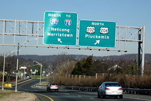 U.S. Route 206 forms a concurrency with U.S. Route 202 past the Somerville Circle and the two routes continue north through Bridgewater Township, briefly entering Somerville
. The road features an interchange with U.S. Route 22
and heads north with the Bridgewater Commons
shopping mall on the east side of the road and the Somerset Corporate Center on the west side of the road. An interchange with Commons Way provides access to both these places. Past Commons Way, the road passes under Garrettson Road and comes to an interchange with Interstate 287
that also provides access to Interstate 78
. Past the Interstate 287 interchange, U.S. Routes 202 and 206 continue north as a two-lane undivided road with residences to the east and corporate parks to the west. The road crosses Chambers Brook into Bedminster Township
, where it soon passes under Interstate 78. Shortly after Interstate 78, it widens into a four-lane divided highway with a Jersey barrier
that runs through a mix of commercial and residential areas. U.S. Routes 202 and 206 come to another interchange with Interstate 287, pass over the North Branch Raritan River again, and come to an intersection where the two routes split.
Upon splitting from U.S. Route 206, U.S. Route 202 heads north on Somerville Road, a two-lane undivided road. It soon meets County Route 523
(Main Street), and U.S. Route 202 makes a right turn to head to the northeast on Lamington Road. The route heads east through residential areas and crosses the North Branch Raritan River into Far Hills
. Upon entering Far Hills, the route intersects County Route 512
(Peapack Road), forming a concurrency that lasts with that route until County Route 512 heads south on Far Hills Road just before U.S. Route 202 crosses New Jersey Transit’s Gladstone Branch
near the Far Hills Station
. From here, the road heads northeast through wooded areas with some clearings and residences, crossing into Bernardsville
. In Bernardsville, U.S. Route 202 heads through rural areas with trees and fields as Mine Brook Road before reaching the town itself. In the town, the route intersects County Route 525
(Claremont Road), briefly running concurrent with that route until it heads south on Mt. Airy Road. From the center of Bernardsville, U.S. Route 202 runs northeast as Morristown Road, crossing into Bernards Township
, where it heads through wooded residential areas. In Bernards Township, the road features an intersection with County Route 613 (Childs Road) and North Maple Avenue, the latter providing access to Interstate 287.
into Harding Township
, Morris County
, where the route becomes Mt. Kemble Avenue. In Harding Township, the road runs north through mostly runs through wooded residential and commercial areas, closely paralleling Interstate 287, which runs to the east of U.S. Route 202. It heads into more heavily wooded areas, running to the east of Morristown National Historical Park
, before continuing northeast into Morris Township
. Here, U.S. Route 202 continues through woodland, but residences start to increase along the road and it passes by an industrial facility. It passes by the Spring Brook Country Club before crossing into Morristown
. Upon entering Morristown, the route heads toward the downtown area, where it splits into a one-way pair
following Market Street northbound and Bank Street southbound. The one-way pair comes to Park Place, a square in the center of Morristown, where U.S. Route 202 meets County Route 510
and Route 124. County Route 510 heads west from the square on Washington Street and east from the square on Morris Street, while Route 124 heads east from the square on South Street. Meanwhile, U.S. Route 202 continues north from Park Place on Speedwell Avenue, a two-lane road that heads past numerous downtown businesses. The route then leaves the downtown area, heading through residential neighborhoods and crossing the Whippany River
before leaving Morristown and crossing back into Morris Township, where it briefly passes through an area of businesses. At the intersection with County Route 650 (Hanover Avenue), U.S. Route 202 crosses into Morris Plains
, where it continues north through suburban commercial and residential areas. The route passes under New Jersey Transit’s Morristown Line
near the Morris Plains Station
and intersects the southern terminus of Route 53
(Tabor Road).
Past the Route 53 intersection, maintenance of U.S. Route 202 is transferred from the New Jersey Department of Transportation to the county and it resumes northeast on Littleton Road, heading through residential areas. It enters an area of corporate parks as it crosses Route 10 and heads into Parsippany-Troy Hills
. After passing through the area of corporate parks, the road heads back through suburban neighborhoods before coming to an interchange with Interstate 80
. In the vicinity of the Interstate 80 interchange, U.S. Route 202 is state maintained. Past the interchange, U.S. Route 202 closely parallels Interstate 80 to the north as a four-lane undivided road before coming to an intersection with County Route 511
(Parsippany Boulevard), where U.S. Route 202 makes a left turn onto that route to form a concurrency.
The two routes continue north on Parsippany Boulevard, a two-lane road that comes to an intersection with U.S. Route 46
, where the road is briefly state maintained. Past U.S. Route 46, the road continues north, intersecting ramps that provide access to and from southbound Interstate 287. Here, the road becomes county maintained again. It passes by business parks and then wooded residential areas, closely paralleling Interstate 287 again. At the intersection with Intervale Road, U.S. Route 202 and County Route 511 make a right turn, immediately interchanging with Interstate 287, with access to the southbound direction and from the northbound direction. The routes follow Intervale Road briefly before making a left turn to resume onto Parsippany Boulevard. The road crosses over the Jersey City Reservoir, which supplies drinking water to Jersey City
, and enters Boonton
, where the road becomes Washington Street. This street carries the two routes through residential areas before coming to another interchange with Interstate 287 that also features access to the southbound direction and access from the northbound direction. Past this interchange, U.S. Route 202 splits from County Route 511 by heading to the northeast on Myrtle Avenue.
Myrtle Avenue carries U.S. Route 202 through commercial areas sandwiched by Interstate 287 to the southeast and New Jersey Transit’s Montclair-Boonton Line
. Along Myrtle Avenue, U.S. Route 202 features ramps to and from southbound Interstate 287. The route crosses into Montville, where it becomes Main Road and runs a farther distance from Interstate 287, heading north through residential areas. The road turns east and makes a left turn to head north on Main Street, which angles east and comes to an interchange with Interstate 287. Past this interchange, U.S. Route 202 continues through commercial areas, crossing over the Montclair-Boonton Line, before heading into residential neighborhoods, running parallel to the Montclair-Boonton Line. After passing Towaco Station
, the route makes a right turn, passes under the railroad line, immediately makes a left turn to resume on Main Street. The route heads east as a four-lane road running to the south of the railroad tracks through residential areas, narrowing to two lanes. It enters Lincoln Park
, where U.S. Route 202 intersects County Route 633 (Boonton Turnpike), continuing east onto Boonton Turnpike. A short distance later, the route intersects County Route 511 Alternate (Comly Road) and forms a wrong-way concurrency with that route. The two routes continue southeast through wooded residential neighborhoods, eventually running parallel to the Pompton River
.
, Passaic County
, where the road becomes Mountainview Boulevard. It crosses the Montclair-Boonton Line near the Mountain View Station
and comes to an interchange with Route 23, where County Route 511 Alternate ends and U.S. Route 202 heads north on Route 23, a six-lane freeway that is state maintained. The road interchanges with County Route 670 (Alps Road) and then with County Route 683 (Newark-Pompton Turnpike
). Route 23 and U.S. Route 202 continue north from this point as a surface road through commercial areas. At a U-turn ramp, the eastbound direction of County Route 504
follows both directions of the road, having to use the ramp in order to continue across the road. Northbound U.S. Route 202 splits from Route 23, where the cut-off intersection with County Route 504 is located. At this point, the westbound direction of County Route 504 and the southbound direction of U.S. Route 202 follow southbound Route 23 until an intersection.
Past Route 23 and County Route 504, U.S. Route 202 heads north on Black Oak Ridge Road, a county maintained road that heads through residential neighborhoods. The road comes to an intersection with County Route 689 (Paterson-Hamburg Turnpike), where U.S. Route 202 merges onto that road, forming a concurrency. The Paterson-Hamburg Turnpike heads north past some businesses, running a short distance to the east of the Ramapo River
, before coming to Terhune Drive, where U.S. Route 202 makes a right turn onto that road with County Route 689 continuing north on Paterson-Hamburg Turnpike. Terhune Drive carries U.S. Route 202 north through wooded neighborhoods, running in between Pines Lake to the east and Pompton Lake, which is part of the Ramapo River, to the west.
 U.S. Route 202 crosses into Oakland
, Bergen County
, where the route becomes Ramapo Valley Road. In Bergen County, U.S. Route 202 is cosigned with County Route 91. In Oakland, the route turns east and passes the Long Hill Mall, where it makes a left turn to continue north along Ramapo Valley Road with County Route 93 continuing straight on Long Hill Road. U.S. Route 202 heads north through commercial areas of the town, where it passes by the Coppertree Mall, before coming to an interchange with Interstate 287. In the vicinity of this interchange, the route is maintained by the state. Past the Interstate 287 interchange, the road continues northeast through residential areas, crossing into Mahwah
. Here, the route parallels the Ramapo River again, which runs to the west of the road. U.S. Route 202 passes through wooded residential areas before passing by Ramapo College of New Jersey. It passes under Interstate 287 and continues northeast, coming to an interchange with Route 17. Past this interchange, U.S. Route 202 heads east and then north through more dense neighborhoods. It passes under a railroad line that serves as part of both New Jersey Transit’s Main Line
and Bergen County Line
before immediately coming to an intersection with County Route 507
(Franklin Turnpike). Here, U.S. Route 202 makes a left turn onto this road and heads 0.03 mi (0.0482802 km) north to the New York state line where it continues into Suffern, New York
as Orange Avenue.
, a historical 18th-century road that linked Philadelphia to New York City
; the Paterson-Hamburg Turnpike, which was chartered on March 3, 1806 to run from Passaic
to the Pennsylvania border; and the Union Turnpike, which was chartered on February 23, 1804 to run from Morristown to the Pennsylvania border. When the original system
of New Jersey state highways was established, the current routing of U.S. Route 202 was legislated as part of pre-1927 Route 5 between Morristown and present-day Route 53 in Morris Plains in 1916 and as part of pre-1927 Route 16 between Somerville ans Morristown in 1921. In the 1927 New Jersey state highway renumbering
, present-day U.S. Route 202 was legislated as part of Route 29 between Lambertville and Ringoes, Route 30 (now Route 31) between Ringoes and Flemington, Route 12 between Flemington and Somerville, Route 31 (now U.S. Route 206) between Somerville and Bedminster, Route 32 from Bedminster to Mountain View, and Route 23 through a portion of Wayne. Also, by 1927, U.S. Route 122 was signed to run from the New Hope-Lambertville Bridge
over the Delaware River in Lambertville, where it continued south all the way to State Road, Delaware, to White House
, following locally maintained Bridge Street in Lambertville, Route 29 between Lambertville and Ringoes, Route 30 between Ringoes and Flemington, and present-day County Route 523 from Flemington to U.S. Route 22 in White House.
Eventually, Route 29 was realigned to follow present-day U.S. Route 202 between Ringoes and Somerville, replacing Route 12 between Flemington and Somerville. In the mid-1930s, U.S. Route 122 was renumbered to U.S. Route 202 and was rerouted to head from Flemington to the New York border at Suffern, where it would continue to Bangor, Maine
. U.S. Route 202 would follow newly-built Route 29 from Flemington northeast to Somerville; Route 31 north to Bedminster; Route 32 northeast to Mountain View, which was state maintained south of Route 5N (now Route 53) in Morris Plains; Route 23 in Wayne; and county roads from Route 23 northeast to the New York border. In 1948, Bridge Street in Lambertville from the New Hope-Lambertville Bridge to Route 29 was designated as Route S29. In the 1953 New Jersey state highway renumbering
, which eliminated long concurrencies between U.S. and state routes, many of the state routes that followed U.S. Route 202 were removed from the route. Route 29 was removed from U.S. Route 202 and rerouted to follow former Route 29A to Frenchtown
, and Routes S29, 31, and 32 were entirely eliminated. In addition, Route 30 was renumbered to Route 69 as it conflicted with U.S. Route 30
in southern New Jersey.
Plans for a limited-access highway along the U.S. Route 202 corridor date back to 1932 when a parkway
was planned to continue into Pennsylvania along U.S. Route 202; this proposal never came to fruition. In the 1960s, a bypass around Ringoes opened for U.S. Route 202 and Route 69 (which became Route 31 in 1967) with the former alignment of U.S. Route 202 through town becoming Route 179. In 1966, a freeway was proposed along the U.S. Route 202 corridor between the Pennsylvania border and Interstate 287 in Bridgewater Township. The portion of this freeway between the Pennsylvania border and the Route 179 interchange in Ringoes was legislated in 1969 with the New Hope-Lambertville Toll Bridge
opening in 1971. The freeway opened in October 1974, and the former alignment of U.S. Route 202 between Lambertville and Ringoes became an extension of Route 179. Meanwhile, the portion of the proposed U.S. Route 202 freeway between Lambertville and Bridgewater Township was cancelled due to opposition from residents along the route.
In the 1980s, upgrades were made to the portion of U.S. Route 202 concurrent with Route 23. This portion of road, which was originally a four-lane undivided road, saw an upgrade to a six-lane freeway south of the Alps Road interchange and to a six-lane surface road north of there. Construction on these improvements began in 1983 and were completed in 1986. There were also plans to replace the Flemington Circle with an interchange as part of a project that would have also built a limited-access bypass of Flemington for Route 31; however, this plan was never realized.
!County
!Location
!Mile
!Roads
!Notes
|-
|colspan=5 align="center"|New Hope-Lambertville Toll Bridge
over Delaware River
|-
|rowspan=7|Hunterdon
|Delaware Township
|0.35
|
|Southbound exit and northbound entrance from northbound NJ 29 provided by Alexauken Creek Road
|-
|West Amwell Township
|2.81
|
|
|-
|rowspan=4|East Amwell Township
|4.98
|
|
|-
|5.70
|
|No southbound entrance, south end of NJ 31 overlap
|-
|colspan=5 align="center"|North end of freeway
|-
|6.95
|
|
|-
|Flemington
|11.44
|
|Flemington Circle, north end of NJ 31 overlap
|-
|rowspan=13|Somerset
|Raritan
|23.90
|
|
|-
|Raritan
/Bridgewater Township
|24.43
|
|Interchange, former Somerville Circle
, south end of US 206 overlap
|-
|rowspan=3|Bridgewater Township
|25.03
|, New York City
|Interchange
|-
|25.50
|Commons Way
|Interchange
|-
|25.88
|
|Northbound exit, southbound entrance; I-287 exit 17
|-
|rowspan=4|Bedminster Township
|30.51
|
|I-287 exit 22
|-
|31.04
|AT&T Road
|Interchange
|-
|31.51
|
|North end of US 206 overlap
|-
|32.13
|
|
|-
|rowspan=2|Far Hills
|32.60
|
|South end of CR 512 overlap
|-
|32.88
|
|North end of CR 512 overlap
|-
|rowspan=2|Bernardsville
|36.97
|
|South end of CR 525 overlap
|-
|37.10
|
|North end of CR 525 overlap
|-
|rowspan=14|Morris
|rowspan=2|Morristown
|44.53
|
|South end of CR 510 overlap
|-
|44.60
|
|North end of CR 510 overlap
|-
|Morris Plains
|46.99
|
|
|-
|Morris Plains
/Parsippany-Troy Hills
|48.23
|
|
|-
|rowspan=5|Parsippany-Troy Hills
|50.46
|, New York City
|I-80 exit 42
|-
|51.14
|
|South end of CR 511 overlap
|-
|51.53
|
|
|-
|51.82
|
|Access to southbound I-287, access from southbound I-287; I-287 exit 42
|-
|53.16
|
|Access to southbound I-287, access from northbound I-287; I-287 exit 43
|-
|rowspan=3|Boonton
|54.22
|
|Access to southbound I-287, access from northbound I-287; I-287 exit 44
|-
|54.24
|
|North end of CR 511 overlap
|-
|54.47-55.07
|
|Access to southbound I-287, access from southbound I-287; I-287 exit 45
|-
|Montville
|56.69
|
|I-287 exit 47
|-
|Lincoln Park
|60.59
|
|South end of CR 511 Alt. overlap
|-
|rowspan=7|Passaic
|rowspan=7|Wayne
|62.95
|
|Interchange, north end of CR 511 Alt. overlap, south end of NJ 23 overlap
|-
|colspan=5 align="center"|South end of freeway
|-
|63.34
|
|
|-
|colspan=5 align="center"|North end of freeway
|-
|63.81
|
|Interchange
|-
|65.07
|
|North end of NJ 23 overlap, no direct access for CR 504 across intersection
|-
|65.40
|
|
|-
|rowspan=4|Bergen
|Oakland
|72.54
|
|I-287 exit 58
|-
|rowspan=3|Mahwah
|79.30
|
|Interchange
|-
|80.27
|
|South end of CR 507 overlap
|-
|80.31
|
|New York
state line
New Castle, Delaware
New Castle is a city in New Castle County, Delaware, six miles south of Wilmington, situated on the Delaware River. In 1900, 3,380 people lived here; in 1910, 3,351...
northeast to Bangor, Maine
Bangor, Maine
Bangor is a city in and the county seat of Penobscot County, Maine, United States, and the major commercial and cultural center for eastern and northern Maine...
. In the U.S. state
U.S. state
A U.S. state is any one of the 50 federated states of the United States of America that share sovereignty with the federal government. Because of this shared sovereignty, an American is a citizen both of the federal entity and of his or her state of domicile. Four states use the official title of...
of New Jersey
New Jersey
New Jersey is a state in the Northeastern and Middle Atlantic regions of the United States. , its population was 8,791,894. It is bordered on the north and east by the state of New York, on the southeast and south by the Atlantic Ocean, on the west by Pennsylvania and on the southwest by Delaware...
, the route runs 80.31 mi (129.25 km) from the New Hope-Lambertville Toll Bridge
New Hope-Lambertville Toll Bridge
The New Hope-Lambertville Toll Bridge carries U.S. Route 202 over the Delaware River, connecting Delaware Township in Hunterdon County with Solebury Township in Bucks County. The bridge, which opened in 1971, was built and is currently operated by the Delaware River Joint Toll Bridge Commission...
over the Delaware River
Delaware River
The Delaware River is a major river on the Atlantic coast of the United States.A Dutch expedition led by Henry Hudson in 1609 first mapped the river. The river was christened the South River in the New Netherland colony that followed, in contrast to the North River, as the Hudson River was then...
at the Pennsylvania
Pennsylvania
The Commonwealth of Pennsylvania is a U.S. state that is located in the Northeastern and Mid-Atlantic regions of the United States. The state borders Delaware and Maryland to the south, West Virginia to the southwest, Ohio to the west, New York and Ontario, Canada, to the north, and New Jersey to...
border in Delaware Township
Delaware Township, Hunterdon County, New Jersey
-Demographics:As of the census of 2000, there were 4,478 people, 1,643 households, and 1,302 families residing in the township. The population density was 121.9 people per square mile . There were 1,701 housing units at an average density of 46.3 per square mile...
, Hunterdon County
Hunterdon County, New Jersey
Hunterdon County is a county located in the western section of the U.S. state of New Jersey. As of the 2010 United States Census, the population was 128,349. It is part of the New York Metropolitan Area. Its county seat is Flemington....
near Lambertville
Lambertville, New Jersey
Lambertville is a city in Hunterdon County, New Jersey, United States. As of the 2010 United States Census, the city population was 3,906.Lambertville was originally incorporated as a town by an Act of the New Jersey Legislature on March 1, 1849, from portions of West Amwell Township...
northeast to the New York
New York
New York is a state in the Northeastern region of the United States. It is the nation's third most populous state. New York is bordered by New Jersey and Pennsylvania to the south, and by Connecticut, Massachusetts and Vermont to the east...
border in Mahwah
Mahwah, New Jersey
Mahwah is a township in Bergen County, New Jersey, United States. As of the 2010 United States Census, the township population was 25,890. The name Mahwah is derived from the Lenni Lenape word "mawewi" which means "Meeting Place" or "Place Where Paths Meet".The area that is now Mahwah was...
, Bergen County
Bergen County, New Jersey
Bergen County is the most populous county of the state of New Jersey, United States. As of the 2010 United States Census, its population was 905,116. The county is part of the New York City Metropolitan Area. Its county seat is Hackensack...
. Along the route’s journey, it passes through a variety of suburban and rural environments, including the communities of Flemington
Flemington, New Jersey
Flemington is a borough in Hunterdon County, New Jersey, United States. As of the United States 2010 Census, the borough population was 4,581. It is the county seat of Hunterdon County....
, Somerville
Somerville, New Jersey
Somerville is a borough in Somerset County, New Jersey, United States. As of the 2010 United States Census, the borough population was 12,098. It is the county seat of Somerset County....
, Morristown
Morristown, New Jersey
Morristown is a town in Morris County, New Jersey, United States. As of the 2010 United States Census, the town population was 18,411. It is the county seat of Morris County. Morristown became characterized as "the military capital of the American Revolution" because of its strategic role in the...
, Parsippany-Troy Hills
Parsippany-Troy Hills, New Jersey
Parsippany-Troy Hills Township, commonly called Parsippany, is a township in Morris County, New Jersey, United States. As of the 2000 United States Census, the township population was 50,649. The name Parsippany comes from the Lenape Native American word parsipanong, which means "the place where...
, Wayne
Wayne, New Jersey
Wayne is a Township in Passaic County, New Jersey, United States, located less than from midtown Manhattan. As of the United States 2000 Census, the township had a total population of 54,069....
, and Oakland
Oakland, New Jersey
Oakland is a borough in Bergen County, New Jersey, United States. As of the 2010 United States Census, the borough population was 12,754.Oakland was incorporated as a borough by an Act of the New Jersey Legislature on April 8, 1902, from portions of Franklin Township.-History:The Van Allen House...
as well as five counties: Hunterdon, Somerset
Somerset County, New Jersey
Somerset County is a county located in the U.S. state of New Jersey. In 2010, the population was 323,444. It is part of the New York Metropolitan Area. Its county seat is Somerville....
, Morris
Morris County, New Jersey
Morris County is a county located in the U.S. state of New Jersey, about west of New York City. According to the United States 2010 Census, the population was 492,276. It is part of the New York Metropolitan Area. Its county seat is Morristown....
, Passaic
Passaic County, New Jersey
Passaic County is a county located in the U.S. state of New Jersey. As of the 2010 Census, the population was 501,226. Its county seat is Paterson...
, and Bergen. U.S. Route 202 encounters many major roads in New Jersey, including Route 31, U.S. Route 206
U.S. Route 206
U.S. Route 206 is a long north–south United States highway in New Jersey and Pennsylvania, United States. Only about a half a mile of its length is in Pennsylvania; the Milford-Montague Toll Bridge carries it over the Delaware River into New Jersey, where it is the remainder of the route...
, U.S. Route 22
U.S. Route 22 in New Jersey
U.S. Route 22 is a U.S. highway stretching from Cincinnati, Ohio in the west to Newark, New Jersey in the east. In New Jersey, the route runs for from the Easton-Phillipsburg Toll Bridge over the Delaware River in Phillipsburg, Warren County to Interstate 78 , US 1/9, and Route 21 at the Newark...
, Interstate 80
Interstate 80 in New Jersey
Interstate 80 is a major Interstate Highway in the United States, running from the New York City Metropolitan Area westward to San Francisco, California...
, U.S. Route 46
U.S. Route 46
U.S. Route 46 is an east–west U.S. Highway, running for , completely within the state of New Jersey. The west end is at an interchange with Interstate 80 and Route 94 in Columbia, Warren County on the Delaware River...
, Route 23, and Route 17. From Somerville to the New York border, U.S. Route 202 generally runs within a close distance of Interstate 287
Interstate 287
Interstate 287 is an auxiliary Interstate Highway in the U.S. states of New Jersey and New York. It is a partial beltway around New York City, serving the northern half of New Jersey and the counties of Rockland and Westchester in New York...
and interchanges with that route several times. The road ranges from a four-lane freeway between Lambertville and Ringoes in Hunterdon County to a two-lane undivided road through much of the northern portion of the route. North of the Route 53
New Jersey Route 53
-External links:***...
intersection in Morris Plains
Morris Plains, New Jersey
Morris Plains, billing itself "the Community of Caring," is a Borough in Morris County, New Jersey, United States. As of the United States 2000 Census, the borough population was 5,236....
, U.S. Route 202 is maintained by individual counties rather than the New Jersey Department of Transportation
New Jersey Department of Transportation
The New Jersey Department of Transportation is the agency responsible for transportation issues and policy in New Jersey. It is headed by the Commissioner of Transportation...
with a few exceptions.
In the original system
History of state highways in New Jersey (pre-1927)
New Jersey was one of the first U.S. states to adopt a system of numbered state highways. The Egan Bill designated the initial system of 13 routes:*Route 1, Elizabeth - Rahway - New Brunswick - Hightstown - Trenton...
of New Jersey state highways, present-day U.S. Route 202 was legislated as pre-1927 Route 5 between Morristown and Morris Plains in 1916 and as pre-1927 Route 16 between Somerville and Morristown in 1921. In 1927, the current route was designated as Route 29 between Lambertville and Ringoes, Route 30 (now Route 31) between Ringoes and Flemington, Route 12 between Flemington and Somerville, Route 31 (now U.S. Route 206) between Somerville and Bedminster, Route 32 between Bedminster and Mountain View, and Route 23 within a portion of Wayne. Meanwhile, U.S. Route 122 was signed in New Jersey to run from the New Hope-Lambertville Bridge
New Hope-Lambertville Bridge
The New Hope-Lambertville Bridge, officially called the New Hope-Lambertville Toll Supported Bridge, is a six-span, -long bridge spanning the Delaware River that connects the city of Lambertville in Hunterdon County, New Jersey with the borough of New Hope in Bucks County, Pennsylvania. The current...
in Lambertville, where the route continued south to State Road, Delaware, along Bridge Street, Route 29, and Route 30 to Flemington, and then along present-day County Route 523
County Route 523 (New Jersey)
County Route 523 is a county highway in the U.S. state of New Jersey. The highway extends from Main Street in Stockton to Hillside Avenue in Bedminster Township.-Hunterdon County:...
to U.S. Route 22 in White House
Whitehouse, New Jersey
Whitehouse is a village in Readington Township, New Jersey along the Jersey Turnpike, just west of Mechanicsville.In 1722, Abraham Van Horn purchased in Readington along the Rockaway Creek. He built a grist mill and saw mill here...
. In the mid 1930s, U.S. Route 122 was renumbered to U.S. Route 202, and realigned to follow its current route to New York border near Suffern, New York
Suffern, New York
Suffern is a village in the Town of Ramapo, Rockland County, New York, United States located north of the State of New Jersey; east of Hillburn; south of Montebello and west of Airmont...
where it continued to Bangor, Maine
Bangor, Maine
Bangor is a city in and the county seat of Penobscot County, Maine, United States, and the major commercial and cultural center for eastern and northern Maine...
. In 1953, all the state highway designations were removed from U.S. Route 202 except for Route 23 and Route 30 (which became Route 69 before becoming Route 31 in 1967) to avoid long concurrencies with the route. In the 1960s, plans were made to upgrade U.S. Route 202 to a freeway between the Pennsylvania border and Interstate 287 in Bridgewater Township. The only parts of this freeway that were completed were a bypass of Ringoes in the 1960s and a freeway between the Delaware River and Ringoes in 1974; the rest was canceled due to opposition from residents along the route. With the completion of the U.S. Route 202 freeway in Hunterdon County, the former alignment became Route 179. The portion of U.S. Route 202 concurrent with Route 23 in Wayne was upgraded from a four-lane road to a six-lane road in the 1980s.
Hunterdon County
U.S. Route 202 crosses into Delaware TownshipDelaware Township, Hunterdon County, New Jersey
-Demographics:As of the census of 2000, there were 4,478 people, 1,643 households, and 1,302 families residing in the township. The population density was 121.9 people per square mile . There were 1,701 housing units at an average density of 46.3 per square mile...
in Hunterdon County, New Jersey
Hunterdon County, New Jersey
Hunterdon County is a county located in the western section of the U.S. state of New Jersey. As of the 2010 United States Census, the population was 128,349. It is part of the New York Metropolitan Area. Its county seat is Flemington....
on the New Hope-Lambertville Toll Bridge
New Hope-Lambertville Toll Bridge
The New Hope-Lambertville Toll Bridge carries U.S. Route 202 over the Delaware River, connecting Delaware Township in Hunterdon County with Solebury Township in Bucks County. The bridge, which opened in 1971, was built and is currently operated by the Delaware River Joint Toll Bridge Commission...
over the Delaware River
Delaware River
The Delaware River is a major river on the Atlantic coast of the United States.A Dutch expedition led by Henry Hudson in 1609 first mapped the river. The river was christened the South River in the New Netherland colony that followed, in contrast to the North River, as the Hudson River was then...
from Solebury Township, Pennsylvania
Solebury Township, Pennsylvania
Solebury Township is a township in Bucks County, Pennsylvania, United States. The population was 8,692 at the 2010 census.The Solebury School is located in the township, off U.S...
, heading to the northeast as a four-lane freeway maintained by the Delaware River Joint Toll Bridge Commission
Delaware River Joint Toll Bridge Commission
The Delaware River Joint Toll Bridge Commission is a bistate, public agency charged with providing safe, dependable and efficient river crossings between Pennsylvania and New Jersey. The DRJTBC was established under legislation enacted in the two states in 1934. The federal Compact for the...
. Shortly after entering New Jersey, the route passes over the Delaware and Raritan Canal
Delaware and Raritan Canal
The Delaware and Raritan Canal is a canal in central New Jersey, United States, built in the 1830s that served to connect the Delaware River to the Raritan River. It was intended as an efficient and reliable means of transportation of freight between Philadelphia, Pennsylvania and New York City,...
comes to an interchange with Route 29 that features a northbound exit, a northbound entrance from southbound Route 29, and a southbound entrance. The route becomes maintained by the New Jersey Department of Transportation
New Jersey Department of Transportation
The New Jersey Department of Transportation is the agency responsible for transportation issues and policy in New Jersey. It is headed by the Commissioner of Transportation...
here and crosses the Alexauken Creek into Lambertville
Lambertville, New Jersey
Lambertville is a city in Hunterdon County, New Jersey, United States. As of the 2010 United States Census, the city population was 3,906.Lambertville was originally incorporated as a town by an Act of the New Jersey Legislature on March 1, 1849, from portions of West Amwell Township...
where the route features a southbound exit and northbound entrance with Alexauken Creek Road that provides access to Route 29 from southbound U.S. Route 202 and to northbound U.S. Route 202 from northbound Route 29. Past Alexauken Creek Road, the freeway enters West Amwell Township
West Amwell Township, New Jersey
The Delaware River separates West Amwell from the Commonwealth of Pennsylvania.-Demographics:As of the census of 2000, there were 2,383 people, 949 households, and 696 families residing in the township. The population density was 109.7 people per square mile . There were 984 housing units at an...
, where it heads through a mix of woodland and farmland. It comes to a diamond interchange
Diamond interchange
A diamond interchange is a common type of road junction, used where a freeway crosses a minor road. The freeway itself is grade-separated from the minor road, one crossing the other over a bridge...
with County Route 605 (Queen Road), which provides access to Mount Airy and Dilts Corner. Past the County Route 605 interchange, U.S. Route 202 continues northeast through agricultural areas, paralleled by Frontage Road to the north. It crosses into East Amwell Township
East Amwell Township, New Jersey
-History:During the American Revolutionary War, a small but important skirmish occurred in East Amwell when local militia under Capt. John Schenck ambushed a party of British dragoons near Larison's Corner...
and features to a partial cloverleaf interchange with Route 179. Past the Route 179 interchange, the road runs briefly through West Amwell Township before entering East Amwell Township again, bypassing the community of Ringoes
Ringoes, New Jersey
Ringoes is an unincorporated area located within East Amwell Township, in Hunterdon County, New Jersey. The community is served by the United States Postal Service as ZIP Code 08551. As of the United States 2000 Census, the population for ZIP Code Tabulation Area 08551 was 5,082.-History:Ringoes is...
. It comes to a partial interchange with Route 31 and County Route 579
County Route 579 (New Jersey)
County Route 579, abbreviated CR 579, is a county highway in the U.S. state of New Jersey. The highway extends from John Fitch Parkway in Trenton to Route 173 in Greenwich Township.-Mercer County:...
, with access to southbound Route 31 and County Route 579 from both directions of U.S. Route 202 and access to northbound U.S. Route 202 from northbound Route 31 and County Route 579.
Here, Route 31 begins a concurrency
Concurrency (road)
A concurrency, overlap, or coincidence in a road network is an instance of one physical road bearing two or more different highway, motorway, or other route numbers...
with U.S. Route 202, and both routes continue north as a four-lane divided surface road with jughandle
Jughandle
A jughandle is a type of ramp or slip road that changes the way traffic turns left at at-grade intersections. Instead of a standard left turn being made from the left lane, left-turning traffic uses a ramp on the right side of the road...
s, intersecting County Route 602 (Wertsville Road). The next intersection is for Old York Road
Old York Road
Old York Road or King's Highway is a roadway that was built in the 18th century to connect Philadelphia, Pennsylvania with New York City, New York. Through New Jersey it was built along the Raritan "Naraticong Trail"...
, which heads to the southwest as Route 179 and to the northeast as County Route 514
County Route 514 (New Jersey)
County Route 514 is a county highway in the U.S. state of New Jersey. The highway extends from US 202 in East Amwell Township to Bayway Avenue in Elizabeth...
. Shortly past this intersection, the route briefly forms the border between East Amwell Township to the west and Raritan Township
Raritan Township, New Jersey
Raritan Township is a Township in Hunterdon County, New Jersey, United States. As of the United States 2010 Census, the township population was 22,185...
to the east before crossing entirely into Raritan Township. The road continues north through farms, reaching commercial development as it approaches the Flemington
Flemington, New Jersey
Flemington is a borough in Hunterdon County, New Jersey, United States. As of the United States 2010 Census, the borough population was 4,581. It is the county seat of Hunterdon County....
area. Past the intersection with County Route 611 (South Main Street), the road widens to six lanes and crosses into Flemington. The road comes to the Flemington Circle where Route 31 heads north and Route 12 heads west.
Past the Flemington Circle, U.S. Route 202 proceeds northeast on a four-lane divided highway that crosses back into Raritan Township. It heads through woodland, passing by Northlandz, which is home to the world's largest model railroad in HO scale
HO scale
HO or H0 is the most popular scale of model railway in the world.According to the NMRA standard S-1.2 predominantly used in North America, in HO scale, represents 1 real foot ; this ratio works out to about 1:87.1. According to the MOROP standard NEM 010 predominantly used in Europe, the scale is...
. The road crosses the South Branch Raritan River
South Branch Raritan River
The South Branch Raritan River is a tributary of the Raritan River in central New Jersey in the United States.The source of the South Branch is the outflow from Budd Lake, a glacial remnant located a few miles northeast of Hackettstown...
into Readington Township
Readington Township, New Jersey
Readington Township is a Township located in the easternmost portion of Hunterdon County, New Jersey. As of the 2010 United States Census, the township population was 16,126...
, where it heads east, passing over a Norfolk Southern rail line north of Three Bridges
Three Bridges, New Jersey
Three Bridges is an unincorproated community in Hunterdon County, New Jersey, United States, on the South Branch Raritan River, named for the three original bridges there which crossed the river. Farmers, John Vlerebone and Harriet Foster Cline were original land owners in the area of Three Bridges...
. Past Three Bridges, the route runs through a mix of woods and farms.
Somerset County
U.S. Route 202 crosses into Branchburg TownshipBranchburg Township, New Jersey
Branchburg Township is a township in Somerset County, New Jersey, United States. As of the 2010 United States Census, the township population was 14,459....
, where it crosses Old York Road again. It continues northeast through agricultural areas with residences and businesses increasing along the road After crossing Old York Road (County Route 637) another time, the route heads through suburban commercial areas. It passes over the North Branch Raritan River
North Branch Raritan River
The North Branch Raritan River is a tributary of the Raritan River in central New Jersey in the United States.The North Branch Raritan River rises in central Morris County south of Dover and flows generally southward into Somerset County, around the southern end of the Watchung Mountains...
and enters Bridgewater Township
Bridgewater Township, New Jersey
Bridgewater Township is a township in Somerset County, New Jersey, United States. , the township population was 44,464.Bridgewater Township was originally created by Royal Charter on April 4, 1749, from portions of the Northern precinct, and was incorporated as one of New Jersey's initial group of...
, where it passes under New Jersey Transit
New Jersey Transit
The New Jersey Transit Corporation is a statewide public transportation system serving the United States state of New Jersey, and New York, Orange, and Rockland counties in New York State...
’s Raritan Valley Line
Raritan Valley Line
The Raritan Valley Line is a diesel-engine-powered commuter rail service operated by New Jersey Transit , originating out of Pennsylvania Station, located in Newark, New Jersey, with most trains terminating at the Raritan station, located in Raritan, New Jersey.Some weekday trains continue further...
and runs past a shopping center. U.S. Route 202 heads east into Raritan
Raritan, New Jersey
Raritan is a Borough in Somerset County, New Jersey, United States. As of the United States 2010 Census, the borough population was 6,881.-Geography:Raritan is located at ....
, where it passes through business areas and crosses County Route 567
County Route 567 (New Jersey)
County Route 567, abbreviated CR 567, is a county highway in the U.S. state of New Jersey. The highway extends from Amwell Road in Hillsborough Township to Union Avenue in Raritan Borough.-Route description:...
(First Avenue). Past the County Route 567 intersection, the road comes to the modified Somerville Circle
Somerville Circle
The Somerville Circle is a traffic circle located on the border of Bridgewater Township and Raritan, New Jersey, United States. The circle is at the intersection of U.S. Routes 202 and 206, and New Jersey Route 28...
, where it intersects U.S. Route 206
U.S. Route 206
U.S. Route 206 is a long north–south United States highway in New Jersey and Pennsylvania, United States. Only about a half a mile of its length is in Pennsylvania; the Milford-Montague Toll Bridge carries it over the Delaware River into New Jersey, where it is the remainder of the route...
and Route 28. U.S. Route 202 passes over the circle with ramps to U.S. Route 206 and Route 28, which head through the circle.
Somerville, New Jersey
Somerville is a borough in Somerset County, New Jersey, United States. As of the 2010 United States Census, the borough population was 12,098. It is the county seat of Somerset County....
. The road features an interchange with U.S. Route 22
U.S. Route 22 in New Jersey
U.S. Route 22 is a U.S. highway stretching from Cincinnati, Ohio in the west to Newark, New Jersey in the east. In New Jersey, the route runs for from the Easton-Phillipsburg Toll Bridge over the Delaware River in Phillipsburg, Warren County to Interstate 78 , US 1/9, and Route 21 at the Newark...
and heads north with the Bridgewater Commons
Bridgewater Commons
Bridgewater Commons is a fully enclosed mall located in Bridgewater Township, New Jersey. The mall is located at the intersection of U.S. Route 22 and U.S. Route 202/U.S. Route 206 and borders Interstate 287. The mall opened in 1989 and has a gross leasable area of...
shopping mall on the east side of the road and the Somerset Corporate Center on the west side of the road. An interchange with Commons Way provides access to both these places. Past Commons Way, the road passes under Garrettson Road and comes to an interchange with Interstate 287
Interstate 287
Interstate 287 is an auxiliary Interstate Highway in the U.S. states of New Jersey and New York. It is a partial beltway around New York City, serving the northern half of New Jersey and the counties of Rockland and Westchester in New York...
that also provides access to Interstate 78
Interstate 78 in New Jersey
Interstate 78 is an east–west route stretching from Union Township, Lebanon County, Pennsylvania to New York City. In New Jersey, I-78 is called the Phillipsburg–Newark Expressway and the Newark Bay Extension of the New Jersey Turnpike...
. Past the Interstate 287 interchange, U.S. Routes 202 and 206 continue north as a two-lane undivided road with residences to the east and corporate parks to the west. The road crosses Chambers Brook into Bedminster Township
Bedminster Township, New Jersey
Bedminster Township is a Township in Somerset County, New Jersey, United States. As of the 2010 United States Census, the township population was 8,165....
, where it soon passes under Interstate 78. Shortly after Interstate 78, it widens into a four-lane divided highway with a Jersey barrier
Jersey barrier
A Jersey barrier or Jersey wall is a modular concrete barrier employed to separate lanes of traffic. It is designed to both minimize vehicle damage in cases of incidental contact while still preventing crossover in the case of head-on accidents....
that runs through a mix of commercial and residential areas. U.S. Routes 202 and 206 come to another interchange with Interstate 287, pass over the North Branch Raritan River again, and come to an intersection where the two routes split.
Upon splitting from U.S. Route 206, U.S. Route 202 heads north on Somerville Road, a two-lane undivided road. It soon meets County Route 523
County Route 523 (New Jersey)
County Route 523 is a county highway in the U.S. state of New Jersey. The highway extends from Main Street in Stockton to Hillside Avenue in Bedminster Township.-Hunterdon County:...
(Main Street), and U.S. Route 202 makes a right turn to head to the northeast on Lamington Road. The route heads east through residential areas and crosses the North Branch Raritan River into Far Hills
Far Hills, New Jersey
Far Hills is a borough in Somerset County, New Jersey, United States. As of the United States 2010 Census, the population was 919.Far Hills was incorporated as a borough based on an Act of the New Jersey Legislature passed on April 7, 1921, from portions of Bernards Township, subject to the results...
. Upon entering Far Hills, the route intersects County Route 512
County Route 512 (New Jersey)
County Route 512 is a county highway in the U.S. state of New Jersey. The highway extends from High Bridge Road in Califon to Springfield Avenue / Route 24 in Summit.-Hunterdon County:...
(Peapack Road), forming a concurrency that lasts with that route until County Route 512 heads south on Far Hills Road just before U.S. Route 202 crosses New Jersey Transit’s Gladstone Branch
Gladstone Branch
The Gladstone Branch is a branch of New Jersey Transit's Morris and Essex Lines. The Gladstone Branch primarily serves commuter trains; freight service is no longer operated...
near the Far Hills Station
Far Hills (NJT station)
Far Hills is a New Jersey Transit station in the borough of Far Hills, New Jersey located at the intersection of Route 202 and CR 512, ½ mile east of U.S...
. From here, the road heads northeast through wooded areas with some clearings and residences, crossing into Bernardsville
Bernardsville, New Jersey
Bernardsville is a borough and affluent suburb in Somerset County, New Jersey, United States. Bernardsville has the 10th-highest per capita income in the state. Nationwide, Bernardsville ranks 75th among the 100 highest-income places in the United States...
. In Bernardsville, U.S. Route 202 heads through rural areas with trees and fields as Mine Brook Road before reaching the town itself. In the town, the route intersects County Route 525
County Route 525 (New Jersey)
County Route 525 is a county highway in the U.S. state of New Jersey. The highway extends from Union Avenue in Bound Brook to Main Street in Mendham Borough....
(Claremont Road), briefly running concurrent with that route until it heads south on Mt. Airy Road. From the center of Bernardsville, U.S. Route 202 runs northeast as Morristown Road, crossing into Bernards Township
Bernards Township, New Jersey
-History:Bernards Township was originally formed by Royal Charter in 1760 as Bernardston Township from remaining portions of Northern precinct. It was incorporated as Bernards Township as one of New Jersey's initial group of 104 townships by an Act of the New Jersey Legislature on February 21, 1798...
, where it heads through wooded residential areas. In Bernards Township, the road features an intersection with County Route 613 (Childs Road) and North Maple Avenue, the latter providing access to Interstate 287.
Morris County
U.S. Route 202 crosses the Passaic RiverPassaic River
The Passaic River is a mature surface river, approximately 80 mi long, in northern New Jersey in the United States. The river in its upper course flows in a highly circuitous route, meandering through the swamp lowlands between the ridge hills of rural and suburban northern New Jersey,...
into Harding Township
Harding Township, New Jersey
- Demographics :As of the census of 2000, there were 3,180 people, 1,180 households, and 940 families residing in the township. The population density was 155.6 people per square mile . There were 1,243 housing units at an average density of 60.8 per square mile...
, Morris County
Morris County, New Jersey
Morris County is a county located in the U.S. state of New Jersey, about west of New York City. According to the United States 2010 Census, the population was 492,276. It is part of the New York Metropolitan Area. Its county seat is Morristown....
, where the route becomes Mt. Kemble Avenue. In Harding Township, the road runs north through mostly runs through wooded residential and commercial areas, closely paralleling Interstate 287, which runs to the east of U.S. Route 202. It heads into more heavily wooded areas, running to the east of Morristown National Historical Park
Morristown National Historical Park
Morristown National Historical Park consists of three sites, the Ford Mansion, Fort Nonsense, and Jockey Hollow that were important during the American Revolutionary War, which began in 1775 and was ended in 1783 by the Treaty of Paris...
, before continuing northeast into Morris Township
Morris Township, New Jersey
Morris Township is a township in Morris County, New Jersey, USA. As of the United States 2000 Census, the township population was 21,796. It is known as the "doughnut" around Morristown since it completely encapsulates it, and has at least five times the area...
. Here, U.S. Route 202 continues through woodland, but residences start to increase along the road and it passes by an industrial facility. It passes by the Spring Brook Country Club before crossing into Morristown
Morristown, New Jersey
Morristown is a town in Morris County, New Jersey, United States. As of the 2010 United States Census, the town population was 18,411. It is the county seat of Morris County. Morristown became characterized as "the military capital of the American Revolution" because of its strategic role in the...
. Upon entering Morristown, the route heads toward the downtown area, where it splits into a one-way pair
One-way pair
A one-way pair, one-way couple, or just couplet is a pair of parallel, usually one-way streets that carry opposite directions of a signed route or major traffic flow, or sometimes opposite directions of a bus or streetcar route....
following Market Street northbound and Bank Street southbound. The one-way pair comes to Park Place, a square in the center of Morristown, where U.S. Route 202 meets County Route 510
County Route 510 (New Jersey)
County Route 510 is a county highway in the U.S. state of New Jersey. The highway extends from North Road in Chester to McCarter Highway in Newark.A separate, westbound portion of CR 510 stretches through Morristown.-Morris County:...
and Route 124. County Route 510 heads west from the square on Washington Street and east from the square on Morris Street, while Route 124 heads east from the square on South Street. Meanwhile, U.S. Route 202 continues north from Park Place on Speedwell Avenue, a two-lane road that heads past numerous downtown businesses. The route then leaves the downtown area, heading through residential neighborhoods and crossing the Whippany River
Whippany River
The Whippany River is a tributary of the Rockaway River, approximately 20 mi long, in northern New Jersey in the United States....
before leaving Morristown and crossing back into Morris Township, where it briefly passes through an area of businesses. At the intersection with County Route 650 (Hanover Avenue), U.S. Route 202 crosses into Morris Plains
Morris Plains, New Jersey
Morris Plains, billing itself "the Community of Caring," is a Borough in Morris County, New Jersey, United States. As of the United States 2000 Census, the borough population was 5,236....
, where it continues north through suburban commercial and residential areas. The route passes under New Jersey Transit’s Morristown Line
Morristown Line
The Morristown Line is one of New Jersey Transit's commuter lines and is one of two branches that run along the Morris and Essex Lines. Out of 60 inbound and 58 outbound daily weekday trains, 28 inbound and 26 outbound trains use the Kearny Connection to Secaucus Junction and New York Penn...
near the Morris Plains Station
Morris Plains (NJT station)
The Morris Plains Station is a New Jersey Transit station in Morris Plains, New Jersey along the Morristown Line at US Route 202.The former Lackawanna station was built in 1915 and has a brick station house. An old freight station just to the north now serves for a local model railroad...
and intersects the southern terminus of Route 53
New Jersey Route 53
-External links:***...
(Tabor Road).
Past the Route 53 intersection, maintenance of U.S. Route 202 is transferred from the New Jersey Department of Transportation to the county and it resumes northeast on Littleton Road, heading through residential areas. It enters an area of corporate parks as it crosses Route 10 and heads into Parsippany-Troy Hills
Parsippany-Troy Hills, New Jersey
Parsippany-Troy Hills Township, commonly called Parsippany, is a township in Morris County, New Jersey, United States. As of the 2000 United States Census, the township population was 50,649. The name Parsippany comes from the Lenape Native American word parsipanong, which means "the place where...
. After passing through the area of corporate parks, the road heads back through suburban neighborhoods before coming to an interchange with Interstate 80
Interstate 80 in New Jersey
Interstate 80 is a major Interstate Highway in the United States, running from the New York City Metropolitan Area westward to San Francisco, California...
. In the vicinity of the Interstate 80 interchange, U.S. Route 202 is state maintained. Past the interchange, U.S. Route 202 closely parallels Interstate 80 to the north as a four-lane undivided road before coming to an intersection with County Route 511
County Route 511 (New Jersey)
County Route 511 is a county highway in the U.S. state of New Jersey. The highway extends 37.44 miles from Columbia Avenue in Morris Township to the New York state line in West Milford....
(Parsippany Boulevard), where U.S. Route 202 makes a left turn onto that route to form a concurrency.
The two routes continue north on Parsippany Boulevard, a two-lane road that comes to an intersection with U.S. Route 46
U.S. Route 46
U.S. Route 46 is an east–west U.S. Highway, running for , completely within the state of New Jersey. The west end is at an interchange with Interstate 80 and Route 94 in Columbia, Warren County on the Delaware River...
, where the road is briefly state maintained. Past U.S. Route 46, the road continues north, intersecting ramps that provide access to and from southbound Interstate 287. Here, the road becomes county maintained again. It passes by business parks and then wooded residential areas, closely paralleling Interstate 287 again. At the intersection with Intervale Road, U.S. Route 202 and County Route 511 make a right turn, immediately interchanging with Interstate 287, with access to the southbound direction and from the northbound direction. The routes follow Intervale Road briefly before making a left turn to resume onto Parsippany Boulevard. The road crosses over the Jersey City Reservoir, which supplies drinking water to Jersey City
Jersey City, New Jersey
Jersey City is the seat of Hudson County, New Jersey, United States.Part of the New York metropolitan area, Jersey City lies between the Hudson River and Upper New York Bay across from Lower Manhattan and the Hackensack River and Newark Bay...
, and enters Boonton
Boonton, New Jersey
Boonton is a town in Morris County, New Jersey that was chartered in 1867. As of the 2010 United States Census, the town population was 8,347. The town was originally called "Boone-Towne" in 1761 in honor of the Colonial Governor Thomas Boone....
, where the road becomes Washington Street. This street carries the two routes through residential areas before coming to another interchange with Interstate 287 that also features access to the southbound direction and access from the northbound direction. Past this interchange, U.S. Route 202 splits from County Route 511 by heading to the northeast on Myrtle Avenue.
Myrtle Avenue carries U.S. Route 202 through commercial areas sandwiched by Interstate 287 to the southeast and New Jersey Transit’s Montclair-Boonton Line
Montclair-Boonton Line
The Montclair-Boonton Line is a commuter rail line of New Jersey Transit Rail Operations. It is part of the Hoboken Division. The line is a consolidation of three individual lines: the former Delaware, Lackawanna & Western Railroad's Montclair Branch, which ran from Hoboken Terminal to Bay Street,...
. Along Myrtle Avenue, U.S. Route 202 features ramps to and from southbound Interstate 287. The route crosses into Montville, where it becomes Main Road and runs a farther distance from Interstate 287, heading north through residential areas. The road turns east and makes a left turn to head north on Main Street, which angles east and comes to an interchange with Interstate 287. Past this interchange, U.S. Route 202 continues through commercial areas, crossing over the Montclair-Boonton Line, before heading into residential neighborhoods, running parallel to the Montclair-Boonton Line. After passing Towaco Station
Towaco (NJT station)
Towaco Station is a New Jersey Transit station in the Towaco section of Montville, New Jersey along the Montclair-Boonton Line. The station was renovated in the late 1990s. The railroad line is currently just one main track, but operated as many as four tracks in the 1920s for transport of...
, the route makes a right turn, passes under the railroad line, immediately makes a left turn to resume on Main Street. The route heads east as a four-lane road running to the south of the railroad tracks through residential areas, narrowing to two lanes. It enters Lincoln Park
Lincoln Park, New Jersey
Lincoln Park is a Borough in Morris County, New Jersey, United States. As of the United States 2000 Census, the borough population was 10,930....
, where U.S. Route 202 intersects County Route 633 (Boonton Turnpike), continuing east onto Boonton Turnpike. A short distance later, the route intersects County Route 511 Alternate (Comly Road) and forms a wrong-way concurrency with that route. The two routes continue southeast through wooded residential neighborhoods, eventually running parallel to the Pompton River
Pompton River
The Pompton River is a tributary of the Passaic River, approximately 8 mi long, in northern New Jersey in the United States....
.
Passaic County
U.S. Route 202 and County Route 511 Alternate cross the Pompton River into WayneWayne, New Jersey
Wayne is a Township in Passaic County, New Jersey, United States, located less than from midtown Manhattan. As of the United States 2000 Census, the township had a total population of 54,069....
, Passaic County
Passaic County, New Jersey
Passaic County is a county located in the U.S. state of New Jersey. As of the 2010 Census, the population was 501,226. Its county seat is Paterson...
, where the road becomes Mountainview Boulevard. It crosses the Montclair-Boonton Line near the Mountain View Station
Mountain View (NJT station)
Mountain View Station, signed on the platform as Mountain View–Wayne, is a station maintained by New Jersey Transit in Wayne, New Jersey. The station is located on the Montclair-Boonton Line, a merge of the Boonton Line and Montclair Branch in 2002. Prior to the Montclair Connection in 2002, ...
and comes to an interchange with Route 23, where County Route 511 Alternate ends and U.S. Route 202 heads north on Route 23, a six-lane freeway that is state maintained. The road interchanges with County Route 670 (Alps Road) and then with County Route 683 (Newark-Pompton Turnpike
Newark-Pompton Turnpike
The Newark-Pompton Turnpike , is a roadway in northern New Jersey that was originally a tolled turnpike. The roadway was first laid out in the mid-18th century and given its name in 1806...
). Route 23 and U.S. Route 202 continue north from this point as a surface road through commercial areas. At a U-turn ramp, the eastbound direction of County Route 504
County Route 504 (New Jersey)
County Route 504 is a county highway in the U.S. state of New Jersey. The highway extends 15.94 miles from Main Street in Montville County Route 504 is a county highway in the U.S. state of New Jersey. The highway extends 15.94 miles (25.65 kilometers) from Main Street in Montville County Route...
follows both directions of the road, having to use the ramp in order to continue across the road. Northbound U.S. Route 202 splits from Route 23, where the cut-off intersection with County Route 504 is located. At this point, the westbound direction of County Route 504 and the southbound direction of U.S. Route 202 follow southbound Route 23 until an intersection.
Past Route 23 and County Route 504, U.S. Route 202 heads north on Black Oak Ridge Road, a county maintained road that heads through residential neighborhoods. The road comes to an intersection with County Route 689 (Paterson-Hamburg Turnpike), where U.S. Route 202 merges onto that road, forming a concurrency. The Paterson-Hamburg Turnpike heads north past some businesses, running a short distance to the east of the Ramapo River
Ramapo River
The Ramapo River is a tributary of the Pompton River, approximately 30 mi long, in southern New York and northern New Jersey in the United States.-Course:...
, before coming to Terhune Drive, where U.S. Route 202 makes a right turn onto that road with County Route 689 continuing north on Paterson-Hamburg Turnpike. Terhune Drive carries U.S. Route 202 north through wooded neighborhoods, running in between Pines Lake to the east and Pompton Lake, which is part of the Ramapo River, to the west.
Bergen County
Oakland, New Jersey
Oakland is a borough in Bergen County, New Jersey, United States. As of the 2010 United States Census, the borough population was 12,754.Oakland was incorporated as a borough by an Act of the New Jersey Legislature on April 8, 1902, from portions of Franklin Township.-History:The Van Allen House...
, Bergen County
Bergen County, New Jersey
Bergen County is the most populous county of the state of New Jersey, United States. As of the 2010 United States Census, its population was 905,116. The county is part of the New York City Metropolitan Area. Its county seat is Hackensack...
, where the route becomes Ramapo Valley Road. In Bergen County, U.S. Route 202 is cosigned with County Route 91. In Oakland, the route turns east and passes the Long Hill Mall, where it makes a left turn to continue north along Ramapo Valley Road with County Route 93 continuing straight on Long Hill Road. U.S. Route 202 heads north through commercial areas of the town, where it passes by the Coppertree Mall, before coming to an interchange with Interstate 287. In the vicinity of this interchange, the route is maintained by the state. Past the Interstate 287 interchange, the road continues northeast through residential areas, crossing into Mahwah
Mahwah, New Jersey
Mahwah is a township in Bergen County, New Jersey, United States. As of the 2010 United States Census, the township population was 25,890. The name Mahwah is derived from the Lenni Lenape word "mawewi" which means "Meeting Place" or "Place Where Paths Meet".The area that is now Mahwah was...
. Here, the route parallels the Ramapo River again, which runs to the west of the road. U.S. Route 202 passes through wooded residential areas before passing by Ramapo College of New Jersey. It passes under Interstate 287 and continues northeast, coming to an interchange with Route 17. Past this interchange, U.S. Route 202 heads east and then north through more dense neighborhoods. It passes under a railroad line that serves as part of both New Jersey Transit’s Main Line
Main Line (NJ Transit)
The Main Line is a rail line owned and operated by New Jersey Transit running from Suffern, New York to Hoboken, New Jersey. It runs daily commuter service and was once the north-south main line of the Erie Lackawanna Railroad...
and Bergen County Line
Bergen County Line
The Bergen County Line is a commuter rail line and service owned and operated by New Jersey Transit in the U.S. state of New Jersey. The line loops off the Main Line between the Meadowlands and Glen Rock, with trains continuing in either direction along the Main Line...
before immediately coming to an intersection with County Route 507
County Route 507 (New Jersey)
County Route 507 is a county highway in the U.S. state of New Jersey. The highway extends from Harrison Avenue on the Kearny-Harrison town line to the New York state line in Mahwah. Between Ho-Ho-Kus and Mahwah, this highway is known as Franklin Turnpike...
(Franklin Turnpike). Here, U.S. Route 202 makes a left turn onto this road and heads 0.03 mi (0.0482802 km) north to the New York state line where it continues into Suffern, New York
Suffern, New York
Suffern is a village in the Town of Ramapo, Rockland County, New York, United States located north of the State of New Jersey; east of Hillburn; south of Montebello and west of Airmont...
as Orange Avenue.
History
The alignment of U.S. Route 202 followed portions of many historical roads, including Old York RoadOld York Road
Old York Road or King's Highway is a roadway that was built in the 18th century to connect Philadelphia, Pennsylvania with New York City, New York. Through New Jersey it was built along the Raritan "Naraticong Trail"...
, a historical 18th-century road that linked Philadelphia to New York City
New York City
New York is the most populous city in the United States and the center of the New York Metropolitan Area, one of the most populous metropolitan areas in the world. New York exerts a significant impact upon global commerce, finance, media, art, fashion, research, technology, education, and...
; the Paterson-Hamburg Turnpike, which was chartered on March 3, 1806 to run from Passaic
Passaic, New Jersey
Passaic is a city in Passaic County, New Jersey, United States. As of the 2010 United States Census, the city had a total population of 69,781, maintaining its status as the 15th largest municipality in New Jersey with an increase of 1,920 residents from the 2000 Census population of 67,861...
to the Pennsylvania border; and the Union Turnpike, which was chartered on February 23, 1804 to run from Morristown to the Pennsylvania border. When the original system
History of state highways in New Jersey (pre-1927)
New Jersey was one of the first U.S. states to adopt a system of numbered state highways. The Egan Bill designated the initial system of 13 routes:*Route 1, Elizabeth - Rahway - New Brunswick - Hightstown - Trenton...
of New Jersey state highways was established, the current routing of U.S. Route 202 was legislated as part of pre-1927 Route 5 between Morristown and present-day Route 53 in Morris Plains in 1916 and as part of pre-1927 Route 16 between Somerville ans Morristown in 1921. In the 1927 New Jersey state highway renumbering
1927 New Jersey state highway renumbering
In 1927, New Jersey's state highways were renumbered. The old system, which had been defined in sequence by the legislature, was growing badly, as several routes shared the same number, and many unnumbered state highways had been defined...
, present-day U.S. Route 202 was legislated as part of Route 29 between Lambertville and Ringoes, Route 30 (now Route 31) between Ringoes and Flemington, Route 12 between Flemington and Somerville, Route 31 (now U.S. Route 206) between Somerville and Bedminster, Route 32 from Bedminster to Mountain View, and Route 23 through a portion of Wayne. Also, by 1927, U.S. Route 122 was signed to run from the New Hope-Lambertville Bridge
New Hope-Lambertville Bridge
The New Hope-Lambertville Bridge, officially called the New Hope-Lambertville Toll Supported Bridge, is a six-span, -long bridge spanning the Delaware River that connects the city of Lambertville in Hunterdon County, New Jersey with the borough of New Hope in Bucks County, Pennsylvania. The current...
over the Delaware River in Lambertville, where it continued south all the way to State Road, Delaware, to White House
Whitehouse, New Jersey
Whitehouse is a village in Readington Township, New Jersey along the Jersey Turnpike, just west of Mechanicsville.In 1722, Abraham Van Horn purchased in Readington along the Rockaway Creek. He built a grist mill and saw mill here...
, following locally maintained Bridge Street in Lambertville, Route 29 between Lambertville and Ringoes, Route 30 between Ringoes and Flemington, and present-day County Route 523 from Flemington to U.S. Route 22 in White House.
Eventually, Route 29 was realigned to follow present-day U.S. Route 202 between Ringoes and Somerville, replacing Route 12 between Flemington and Somerville. In the mid-1930s, U.S. Route 122 was renumbered to U.S. Route 202 and was rerouted to head from Flemington to the New York border at Suffern, where it would continue to Bangor, Maine
Bangor, Maine
Bangor is a city in and the county seat of Penobscot County, Maine, United States, and the major commercial and cultural center for eastern and northern Maine...
. U.S. Route 202 would follow newly-built Route 29 from Flemington northeast to Somerville; Route 31 north to Bedminster; Route 32 northeast to Mountain View, which was state maintained south of Route 5N (now Route 53) in Morris Plains; Route 23 in Wayne; and county roads from Route 23 northeast to the New York border. In 1948, Bridge Street in Lambertville from the New Hope-Lambertville Bridge to Route 29 was designated as Route S29. In the 1953 New Jersey state highway renumbering
1953 New Jersey state highway renumbering
On January 1, 1953, the New Jersey Department of Transportation renumbered many of the State Routes. A few rules were followed in deciding what to renumber:...
, which eliminated long concurrencies between U.S. and state routes, many of the state routes that followed U.S. Route 202 were removed from the route. Route 29 was removed from U.S. Route 202 and rerouted to follow former Route 29A to Frenchtown
Frenchtown, New Jersey
Frenchtown is a Borough in Hunterdon County, New Jersey, United States. As of the United States 2010 Census, the borough population was 1,373....
, and Routes S29, 31, and 32 were entirely eliminated. In addition, Route 30 was renumbered to Route 69 as it conflicted with U.S. Route 30
U.S. Route 30 in New Jersey
U.S. Route 30 is a U.S. highway running from Astoria, Oregon east to Atlantic City, New Jersey. In the U.S. state of New Jersey, US 30 runs from the Benjamin Franklin Bridge at the Delaware River in Camden, Camden County while concurrent with Interstate 676 southeast to Virginia...
in southern New Jersey.
Plans for a limited-access highway along the U.S. Route 202 corridor date back to 1932 when a parkway
Parkway
The term parkway has several distinct principal meanings and numerous synonyms around the world, for either a type of landscaped area or a type of road.Type of landscaped area:...
was planned to continue into Pennsylvania along U.S. Route 202; this proposal never came to fruition. In the 1960s, a bypass around Ringoes opened for U.S. Route 202 and Route 69 (which became Route 31 in 1967) with the former alignment of U.S. Route 202 through town becoming Route 179. In 1966, a freeway was proposed along the U.S. Route 202 corridor between the Pennsylvania border and Interstate 287 in Bridgewater Township. The portion of this freeway between the Pennsylvania border and the Route 179 interchange in Ringoes was legislated in 1969 with the New Hope-Lambertville Toll Bridge
New Hope-Lambertville Toll Bridge
The New Hope-Lambertville Toll Bridge carries U.S. Route 202 over the Delaware River, connecting Delaware Township in Hunterdon County with Solebury Township in Bucks County. The bridge, which opened in 1971, was built and is currently operated by the Delaware River Joint Toll Bridge Commission...
opening in 1971. The freeway opened in October 1974, and the former alignment of U.S. Route 202 between Lambertville and Ringoes became an extension of Route 179. Meanwhile, the portion of the proposed U.S. Route 202 freeway between Lambertville and Bridgewater Township was cancelled due to opposition from residents along the route.
In the 1980s, upgrades were made to the portion of U.S. Route 202 concurrent with Route 23. This portion of road, which was originally a four-lane undivided road, saw an upgrade to a six-lane freeway south of the Alps Road interchange and to a six-lane surface road north of there. Construction on these improvements began in 1983 and were completed in 1986. There were also plans to replace the Flemington Circle with an interchange as part of a project that would have also built a limited-access bypass of Flemington for Route 31; however, this plan was never realized.
Major intersections
{| class=wikitable!County
!Location
!Mile
!Roads
!Notes
|-
|colspan=5 align="center"|New Hope-Lambertville Toll Bridge
New Hope-Lambertville Toll Bridge
The New Hope-Lambertville Toll Bridge carries U.S. Route 202 over the Delaware River, connecting Delaware Township in Hunterdon County with Solebury Township in Bucks County. The bridge, which opened in 1971, was built and is currently operated by the Delaware River Joint Toll Bridge Commission...
over Delaware River
Delaware River
The Delaware River is a major river on the Atlantic coast of the United States.A Dutch expedition led by Henry Hudson in 1609 first mapped the river. The river was christened the South River in the New Netherland colony that followed, in contrast to the North River, as the Hudson River was then...
|-
|rowspan=7|Hunterdon
Hunterdon County, New Jersey
Hunterdon County is a county located in the western section of the U.S. state of New Jersey. As of the 2010 United States Census, the population was 128,349. It is part of the New York Metropolitan Area. Its county seat is Flemington....
|Delaware Township
Delaware Township, Hunterdon County, New Jersey
-Demographics:As of the census of 2000, there were 4,478 people, 1,643 households, and 1,302 families residing in the township. The population density was 121.9 people per square mile . There were 1,701 housing units at an average density of 46.3 per square mile...
|0.35
|
|Southbound exit and northbound entrance from northbound NJ 29 provided by Alexauken Creek Road
|-
|West Amwell Township
West Amwell Township, New Jersey
The Delaware River separates West Amwell from the Commonwealth of Pennsylvania.-Demographics:As of the census of 2000, there were 2,383 people, 949 households, and 696 families residing in the township. The population density was 109.7 people per square mile . There were 984 housing units at an...
|2.81
|
|
|-
|rowspan=4|East Amwell Township
East Amwell Township, New Jersey
-History:During the American Revolutionary War, a small but important skirmish occurred in East Amwell when local militia under Capt. John Schenck ambushed a party of British dragoons near Larison's Corner...
|4.98
|
|
|-
|5.70
|
|No southbound entrance, south end of NJ 31 overlap
|-
|colspan=5 align="center"|North end of freeway
|-
|6.95
|
|
|-
|Flemington
Flemington, New Jersey
Flemington is a borough in Hunterdon County, New Jersey, United States. As of the United States 2010 Census, the borough population was 4,581. It is the county seat of Hunterdon County....
|11.44
|
|Flemington Circle, north end of NJ 31 overlap
|-
|rowspan=13|Somerset
Somerset County, New Jersey
Somerset County is a county located in the U.S. state of New Jersey. In 2010, the population was 323,444. It is part of the New York Metropolitan Area. Its county seat is Somerville....
|Raritan
Raritan, New Jersey
Raritan is a Borough in Somerset County, New Jersey, United States. As of the United States 2010 Census, the borough population was 6,881.-Geography:Raritan is located at ....
|23.90
|
|
|-
|Raritan
Raritan, New Jersey
Raritan is a Borough in Somerset County, New Jersey, United States. As of the United States 2010 Census, the borough population was 6,881.-Geography:Raritan is located at ....
/Bridgewater Township
Bridgewater Township, New Jersey
Bridgewater Township is a township in Somerset County, New Jersey, United States. , the township population was 44,464.Bridgewater Township was originally created by Royal Charter on April 4, 1749, from portions of the Northern precinct, and was incorporated as one of New Jersey's initial group of...
|24.43
|
|Interchange, former Somerville Circle
Somerville Circle
The Somerville Circle is a traffic circle located on the border of Bridgewater Township and Raritan, New Jersey, United States. The circle is at the intersection of U.S. Routes 202 and 206, and New Jersey Route 28...
, south end of US 206 overlap
|-
|rowspan=3|Bridgewater Township
Bridgewater Township, New Jersey
Bridgewater Township is a township in Somerset County, New Jersey, United States. , the township population was 44,464.Bridgewater Township was originally created by Royal Charter on April 4, 1749, from portions of the Northern precinct, and was incorporated as one of New Jersey's initial group of...
|25.03
|, New York City
New York City
New York is the most populous city in the United States and the center of the New York Metropolitan Area, one of the most populous metropolitan areas in the world. New York exerts a significant impact upon global commerce, finance, media, art, fashion, research, technology, education, and...
|Interchange
|-
|25.50
|Commons Way
|Interchange
|-
|25.88
|
|Northbound exit, southbound entrance; I-287 exit 17
|-
|rowspan=4|Bedminster Township
Bedminster Township, New Jersey
Bedminster Township is a Township in Somerset County, New Jersey, United States. As of the 2010 United States Census, the township population was 8,165....
|30.51
|
|I-287 exit 22
|-
|31.04
|AT&T Road
|Interchange
|-
|31.51
|
|North end of US 206 overlap
|-
|32.13
|
|
|-
|rowspan=2|Far Hills
Far Hills, New Jersey
Far Hills is a borough in Somerset County, New Jersey, United States. As of the United States 2010 Census, the population was 919.Far Hills was incorporated as a borough based on an Act of the New Jersey Legislature passed on April 7, 1921, from portions of Bernards Township, subject to the results...
|32.60
|
|South end of CR 512 overlap
|-
|32.88
|
|North end of CR 512 overlap
|-
|rowspan=2|Bernardsville
Bernardsville, New Jersey
Bernardsville is a borough and affluent suburb in Somerset County, New Jersey, United States. Bernardsville has the 10th-highest per capita income in the state. Nationwide, Bernardsville ranks 75th among the 100 highest-income places in the United States...
|36.97
|
|South end of CR 525 overlap
|-
|37.10
|
|North end of CR 525 overlap
|-
|rowspan=14|Morris
Morris County, New Jersey
Morris County is a county located in the U.S. state of New Jersey, about west of New York City. According to the United States 2010 Census, the population was 492,276. It is part of the New York Metropolitan Area. Its county seat is Morristown....
|rowspan=2|Morristown
Morristown, New Jersey
Morristown is a town in Morris County, New Jersey, United States. As of the 2010 United States Census, the town population was 18,411. It is the county seat of Morris County. Morristown became characterized as "the military capital of the American Revolution" because of its strategic role in the...
|44.53
|
|South end of CR 510 overlap
|-
|44.60
|
|North end of CR 510 overlap
|-
|Morris Plains
Morris Plains, New Jersey
Morris Plains, billing itself "the Community of Caring," is a Borough in Morris County, New Jersey, United States. As of the United States 2000 Census, the borough population was 5,236....
|46.99
|
|
|-
|Morris Plains
Morris Plains, New Jersey
Morris Plains, billing itself "the Community of Caring," is a Borough in Morris County, New Jersey, United States. As of the United States 2000 Census, the borough population was 5,236....
/Parsippany-Troy Hills
Parsippany-Troy Hills, New Jersey
Parsippany-Troy Hills Township, commonly called Parsippany, is a township in Morris County, New Jersey, United States. As of the 2000 United States Census, the township population was 50,649. The name Parsippany comes from the Lenape Native American word parsipanong, which means "the place where...
|48.23
|
|
|-
|rowspan=5|Parsippany-Troy Hills
Parsippany-Troy Hills, New Jersey
Parsippany-Troy Hills Township, commonly called Parsippany, is a township in Morris County, New Jersey, United States. As of the 2000 United States Census, the township population was 50,649. The name Parsippany comes from the Lenape Native American word parsipanong, which means "the place where...
|50.46
|, New York City
New York City
New York is the most populous city in the United States and the center of the New York Metropolitan Area, one of the most populous metropolitan areas in the world. New York exerts a significant impact upon global commerce, finance, media, art, fashion, research, technology, education, and...
|I-80 exit 42
|-
|51.14
|
|South end of CR 511 overlap
|-
|51.53
|
|
|-
|51.82
|
|Access to southbound I-287, access from southbound I-287; I-287 exit 42
|-
|53.16
|
|Access to southbound I-287, access from northbound I-287; I-287 exit 43
|-
|rowspan=3|Boonton
Boonton, New Jersey
Boonton is a town in Morris County, New Jersey that was chartered in 1867. As of the 2010 United States Census, the town population was 8,347. The town was originally called "Boone-Towne" in 1761 in honor of the Colonial Governor Thomas Boone....
|54.22
|
|Access to southbound I-287, access from northbound I-287; I-287 exit 44
|-
|54.24
|
|North end of CR 511 overlap
|-
|54.47-55.07
|
|Access to southbound I-287, access from southbound I-287; I-287 exit 45
|-
|Montville
|56.69
|
|I-287 exit 47
|-
|Lincoln Park
Lincoln Park, New Jersey
Lincoln Park is a Borough in Morris County, New Jersey, United States. As of the United States 2000 Census, the borough population was 10,930....
|60.59
|
|South end of CR 511 Alt. overlap
|-
|rowspan=7|Passaic
Passaic County, New Jersey
Passaic County is a county located in the U.S. state of New Jersey. As of the 2010 Census, the population was 501,226. Its county seat is Paterson...
|rowspan=7|Wayne
Wayne, New Jersey
Wayne is a Township in Passaic County, New Jersey, United States, located less than from midtown Manhattan. As of the United States 2000 Census, the township had a total population of 54,069....
|62.95
|
|Interchange, north end of CR 511 Alt. overlap, south end of NJ 23 overlap
|-
|colspan=5 align="center"|South end of freeway
|-
|63.34
|
|
|-
|colspan=5 align="center"|North end of freeway
|-
|63.81
|
|Interchange
|-
|65.07
|
|North end of NJ 23 overlap, no direct access for CR 504 across intersection
|-
|65.40
|
|
|-
|rowspan=4|Bergen
Bergen County, New Jersey
Bergen County is the most populous county of the state of New Jersey, United States. As of the 2010 United States Census, its population was 905,116. The county is part of the New York City Metropolitan Area. Its county seat is Hackensack...
|Oakland
Oakland, New Jersey
Oakland is a borough in Bergen County, New Jersey, United States. As of the 2010 United States Census, the borough population was 12,754.Oakland was incorporated as a borough by an Act of the New Jersey Legislature on April 8, 1902, from portions of Franklin Township.-History:The Van Allen House...
|72.54
|
|I-287 exit 58
|-
|rowspan=3|Mahwah
Mahwah, New Jersey
Mahwah is a township in Bergen County, New Jersey, United States. As of the 2010 United States Census, the township population was 25,890. The name Mahwah is derived from the Lenni Lenape word "mawewi" which means "Meeting Place" or "Place Where Paths Meet".The area that is now Mahwah was...
|79.30
|
|Interchange
|-
|80.27
|
|South end of CR 507 overlap
|-
|80.31
|
|New York
New York
New York is a state in the Northeastern region of the United States. It is the nation's third most populous state. New York is bordered by New Jersey and Pennsylvania to the south, and by Connecticut, Massachusetts and Vermont to the east...
state line