

Proglacial lakes of Minnesota
Encyclopedia
U.S. state
A U.S. state is any one of the 50 federated states of the United States of America that share sovereignty with the federal government. Because of this shared sovereignty, an American is a citizen both of the federal entity and of his or her state of domicile. Four states use the official title of...
of Minnesota
Minnesota
Minnesota is a U.S. state located in the Midwestern United States. The twelfth largest state of the U.S., it is the twenty-first most populous, with 5.3 million residents. Minnesota was carved out of the eastern half of the Minnesota Territory and admitted to the Union as the thirty-second state...
in central North America
North America
North America is a continent wholly within the Northern Hemisphere and almost wholly within the Western Hemisphere. It is also considered a northern subcontinent of the Americas...
in the waning years of the last glacial period. As the Laurentide ice sheet
Laurentide ice sheet
The Laurentide Ice Sheet was a massive sheet of ice that covered hundreds of thousands of square miles, including most of Canada and a large portion of the northern United States, multiple times during Quaternary glacial epochs. It last covered most of northern North America between c. 95,000 and...
decayed at the end of the Wisconsin glaciation, lakes were created in depressions or behind moraine
Moraine
A moraine is any glacially formed accumulation of unconsolidated glacial debris which can occur in currently glaciated and formerly glaciated regions, such as those areas acted upon by a past glacial maximum. This debris may have been plucked off a valley floor as a glacier advanced or it may have...
s left by the glaciers. Evidence for these lakes is provided by low relief topography and glaciolacustrine
Lacustrine
Lacustrine means "of a lake" or "relating to a lake".Specifically, it may refer to:*Lacustrine plain*Lacustrine delta-Fish:*Lacustrine goby , a type of small fish found in Philippine waters belonging to the Gobiidae family, known in Tagalog as dulong-See also:*Fluvial - of or relating a...
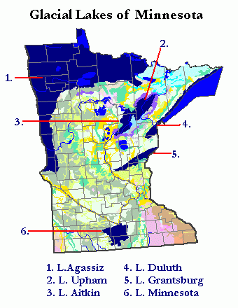
sedimentary deposits. Not all contemporaneous, these glacial lakes drained after the retreat of the lobes of the ice sheets that blocked their outlets, or whose meltwaters fed them. There were a number of large lakes, one of which, Glacial Lake Agassiz, was the largest body of freshwater known to have existed on the North American continent; there were also dozens of smaller and more transitory lakes filled from glacial meltwater, which shrank or dried as the ice sheet retreated north.
Glacial Lake Agassiz
Glacial Lake Agassiz was an enormous lake, larger in area than all the Great LakesGreat Lakes
The Great Lakes are a collection of freshwater lakes located in northeastern North America, on the Canada – United States border. Consisting of Lakes Superior, Michigan, Huron, Erie, and Ontario, they form the largest group of freshwater lakes on Earth by total surface, coming in second by volume...
combined, and the largest body of fresh water ever to have existed in North America. It extended from its outlet near Browns Valley, Minnesota
Browns Valley, Minnesota
As of the census of 2000, there were 690 people, 285 households, and 171 families residing in the city. The population density was 878.5 people per square mile . There were 317 housing units at an average density of 403.6 per square mile...
west into South Dakota
South Dakota
South Dakota is a state located in the Midwestern region of the United States. It is named after the Lakota and Dakota Sioux American Indian tribes. Once a part of Dakota Territory, South Dakota became a state on November 2, 1889. The state has an area of and an estimated population of just over...
and North Dakota
North Dakota
North Dakota is a state located in the Midwestern region of the United States of America, along the Canadian border. The state is bordered by Canada to the north, Minnesota to the east, South Dakota to the south and Montana to the west. North Dakota is the 19th-largest state by area in the U.S....
and north into Saskatchewan
Saskatchewan
Saskatchewan is a prairie province in Canada, which has an area of . Saskatchewan is bordered on the west by Alberta, on the north by the Northwest Territories, on the east by Manitoba, and on the south by the U.S. states of Montana and North Dakota....
, Manitoba
Manitoba
Manitoba is a Canadian prairie province with an area of . The province has over 110,000 lakes and has a largely continental climate because of its flat topography. Agriculture, mostly concentrated in the fertile southern and western parts of the province, is vital to the province's economy; other...
, and Ontario
Ontario
Ontario is a province of Canada, located in east-central Canada. It is Canada's most populous province and second largest in total area. It is home to the nation's most populous city, Toronto, and the nation's capital, Ottawa....
. In Minnesota the lake occupied the Red River Valley
Red River Valley
The Red River Valley is a region in central North America that is drained by the Red River of the North. It is significant in the geography of North Dakota, Minnesota, and Manitoba for its relatively fertile lands and the population centers of Fargo, Moorhead, Grand Forks, and Winnipeg...
in northwestern Minnesota and the western part of the watershed
Drainage basin
A drainage basin is an extent or an area of land where surface water from rain and melting snow or ice converges to a single point, usually the exit of the basin, where the waters join another waterbody, such as a river, lake, reservoir, estuary, wetland, sea, or ocean...
of the Rainy River
Rainy River (Minnesota-Ontario)
The Rainy River is a river, approximately long, which forms part of the U.S.-Canada border separating northern Minnesota and Northwestern Ontario....
in the northern part of the state. Its southern outlet was through the Traverse Gap
Traverse Gap
The Traverse Gap is an ancient river channel occupied by Lake Traverse and Big Stone Lake and the valley connecting them at Browns Valley, Minnesota. It is located on the border of the U.S. states of Minnesota and South Dakota...
, a spillway channel cut through the Big Stone Moraine by Glacial River Warren
Glacial River Warren
right|thumb|210px|The course of the Minnesota River follows the valley carved by Glacial River WarrenGlacial River Warren or River Warren was a prehistoric river that drained Lake Agassiz in central North America between 11,700 and 9,400 years ago...
, an enormous stream which carved the valley of the Minnesota River
Minnesota River
The Minnesota River is a tributary of the Mississippi River, approximately 332 miles long, in the U.S. state of Minnesota. It drains a watershed of nearly , in Minnesota and about in South Dakota and Iowa....
as well as that of the Upper Mississippi River
Upper Mississippi River
The Upper Mississippi River is the portion of the Mississippi River upstream of Cairo, Illinois, United States. From the headwaters at Lake Itasca, Minnesota, the river flows approximately 2000 kilometers to Cairo, where it is joined by the Ohio River to form the Lower Mississippi...
below the confluence of those successor streams. Lake Agassiz' present-day remnants include Lake of the Woods
Lake of the Woods
Lake of the Woods is a lake occupying parts of the Canadian provinces of Ontario and Manitoba and the U.S. state of Minnesota. It separates a small land area of Minnesota from the rest of the United States. The Northwest Angle and the town of Angle Township can only be reached from the rest of...
and Upper and Lower Red Lake
Red Lake (Minnesota)
Red Lake is a lake in Beltrami County in northern Minnesota, USA. It is the largest natural freshwater lake in Minnesota, and the 16th largest lake in the United States. The lake is separated into two sections by a peninsula on the eastern side that almost bisects it in the middle. The community of...
.
Glacial Lake Upham
Glacial Lake Upham was formed in the wake of the retreat of the St. Louis Sublobe of the Des Moines Lobe. It drained through a series of successively lower outlets to Glacial Lake DuluthGlacial Lake Duluth
Glacial Lake Duluth was a proglacial lake that formed in the Lake Superior drainage basin as the Laurentide ice sheet retreated. The oldest existing shorelines were formed after retreat from the Greatlakean advance, sometime around 11,000 years B.P. Lake Duluth formed at the western end of the Lake...
, culminating in the Saint Louis River
Saint Louis River
The St. Louis River is a river in the U.S. states of Minnesota and Wisconsin that flows into Lake Superior. The largest U.S. river to flow into the lake, it is 179 miles in length and starts near Hoyt Lakes, Minnesota. The river's watershed is in area...
. Its former lake bed is now a broad boggy area comprising much of the watershed of the latter stream.
Glacial Lake Aitkin
Glacial Lake Aitkin was also a product of the recession of the St. Louis Sublobe, and for significant portions of its history was contiguous with Glacial Lake Upham. It occupied a broad lowland along the valley of the present-day Mississippi River between Grand RapidsGrand Rapids, Minnesota
As of the census of 2000, there were 7,764 people, 3,446 households, and 1,943 families residing in the city. The population density was 1,057.8 people per square mile . There were 3,621 housing units at an average density of 493.3 per square mile...
and Aitkin
Aitkin, Minnesota
As of the census of 2000, there were 1,984 people, 892 households, and 434 families residing in the city. The population density was 1,150.3 people per square mile . There were 969 housing units at an average density of 561.8 per square mile...
in north central Minnesota. The lake bed is now a sandy and clayey plain.
Glacial Lake Duluth
Glacial Lake DuluthGlacial Lake Duluth
Glacial Lake Duluth was a proglacial lake that formed in the Lake Superior drainage basin as the Laurentide ice sheet retreated. The oldest existing shorelines were formed after retreat from the Greatlakean advance, sometime around 11,000 years B.P. Lake Duluth formed at the western end of the Lake...
is the name given to the largest of a series of named lakes or lake stages occupying parts of the Lake Superior
Lake Superior
Lake Superior is the largest of the five traditionally-demarcated Great Lakes of North America. It is bounded to the north by the Canadian province of Ontario and the U.S. state of Minnesota, and to the south by the U.S. states of Wisconsin and Michigan. It is the largest freshwater lake in the...
basin. As its current outlet to the east was blocked by the Superior Lobe of the ice sheet, Lake Duluth drained through two outlets which crossed the present Laurentian Divide
Laurentian Divide
The Laurentian Divide or Northern Divide is a continental divide dividing the direction of water flow in eastern and southern Canada and the northern Midwestern United States. Water north of the height of land flows to the Arctic Ocean by rivers to Hudson Bay or directly to the Arctic...
to the valley of the Saint Croix River
St. Croix River (Wisconsin-Minnesota)
The St. Croix River is a tributary of the Mississippi River, approximately long, in the U.S. states of Wisconsin and Minnesota. The lower of the river form the border between Wisconsin and Minnesota. The river is a National Scenic Riverway under the protection of the National Park Service. A...
and the Mississippi
Mississippi River
The Mississippi River is the largest river system in North America. Flowing entirely in the United States, this river rises in western Minnesota and meanders slowly southwards for to the Mississippi River Delta at the Gulf of Mexico. With its many tributaries, the Mississippi's watershed drains...
. One outlet was a route from the western part of the lake through the Nemadji River
Nemadji River
The Nemadji River is a river rising in Pine County, Minnesota, United States, which flows through Carlton County, Minnesota and Douglas County, Wisconsin to Lake Superior...
basin and down the present Moose and Kettle Rivers
Kettle River (Minnesota)
The Kettle is a tributary of the St. Croix River, about 80 mi long, in eastern Minnesota in the United States. Via the St. Croix River, it is part of the watershed of the Mississippi River. The river's English name is due to the large number of large rounded holes in the sandstone in and around...
; the other was via the modern Bois Brule River
Bois Brule River
The Bois Brule River is a river situated in Douglas County, Wisconsin, near its eastern border with Bayfield County. The river, which is 44 miles long, rises in central Douglas County near Upper St...
to the Saint Croix. At its peak, Lake Duluth was 148 meters higher than Superior's present level. When the glacier retreated the lake was able to drain to the east.
Glacial Lake Grantsburg
Lake Grantsburg, formed when the Grantsburg Sublobe of the Des Moines Lobe blocked southward drainage of the ice-free land to its north. It extended from St. Cloud east-northeast to Grantsburg, WisconsinGrantsburg, Wisconsin
Grantsburg is a village in Burnett County in the U.S. state of Wisconsin. The population was 1,369 at the 2000 census. The village is located within the Town of Grantsburg.-Claim to fame:...
, whence its outflow ran south along the east front
Ice front
An ice front is the place where a glacier thins and ends. The ice front's position changes as the glacier moves or melts....
of the ice sheet down the valley of the Saint Croix River
St. Croix River (Wisconsin-Minnesota)
The St. Croix River is a tributary of the Mississippi River, approximately long, in the U.S. states of Wisconsin and Minnesota. The lower of the river form the border between Wisconsin and Minnesota. The river is a National Scenic Riverway under the protection of the National Park Service. A...
.
Glacial Lake Minnesota
Lake Minnesota was a complex of lakes formed by or on the Des Moines Lobe generally south of Mankato, MinnesotaMankato, Minnesota
Mankato is a city in Blue Earth, Nicollet, and Le Sueur counties in the U.S. state of Minnesota. The population was 39,309 at the 2010 census, making it the fourth largest city in Minnesota outside of the Minneapolis-St. Paul metropolitan area. The county seat of Blue Earth County, it is located...
. Evidence for it is found in lacustrine
Lake
A lake is a body of relatively still fresh or salt water of considerable size, localized in a basin, that is surrounded by land. Lakes are inland and not part of the ocean and therefore are distinct from lagoons, and are larger and deeper than ponds. Lakes can be contrasted with rivers or streams,...
sediments in that region. The lakes may have consisted of bodies of water trapped on the surface of the decaying ice sheet, lakes created as the lobe retreated, or depressions filled from the overflow of Glacial River Warren
Glacial River Warren
right|thumb|210px|The course of the Minnesota River follows the valley carved by Glacial River WarrenGlacial River Warren or River Warren was a prehistoric river that drained Lake Agassiz in central North America between 11,700 and 9,400 years ago...
.
See also
- Geology of Minnesota
- Glacial history of MinnesotaGlacial history of MinnesotaThe glacial history of Minnesota is most defined since the onset of the last glacial period, which ended some 10,000 years ago. Within the last million years, most of the Midwestern United States and much of Canada were covered at one time or another with an ice sheet. This continental glacier had...
- Laurentide ice sheetLaurentide ice sheetThe Laurentide Ice Sheet was a massive sheet of ice that covered hundreds of thousands of square miles, including most of Canada and a large portion of the northern United States, multiple times during Quaternary glacial epochs. It last covered most of northern North America between c. 95,000 and...
- Wisconsin glaciationWisconsin glaciationThe last glacial period was the most recent glacial period within the current ice age occurring during the last years of the Pleistocene, from approximately 110,000 to 10,000 years ago....
Sources
U.S. state
A U.S. state is any one of the 50 federated states of the United States of America that share sovereignty with the federal government. Because of this shared sovereignty, an American is a citizen both of the federal entity and of his or her state of domicile. Four states use the official title of...
of Minnesota
Minnesota
Minnesota is a U.S. state located in the Midwestern United States. The twelfth largest state of the U.S., it is the twenty-first most populous, with 5.3 million residents. Minnesota was carved out of the eastern half of the Minnesota Territory and admitted to the Union as the thirty-second state...
in central North America
North America
North America is a continent wholly within the Northern Hemisphere and almost wholly within the Western Hemisphere. It is also considered a northern subcontinent of the Americas...
in the waning years of the last glacial period. As the Laurentide ice sheet
Laurentide ice sheet
The Laurentide Ice Sheet was a massive sheet of ice that covered hundreds of thousands of square miles, including most of Canada and a large portion of the northern United States, multiple times during Quaternary glacial epochs. It last covered most of northern North America between c. 95,000 and...
decayed at the end of the Wisconsin glaciation, lakes were created in depressions or behind moraine
Moraine
A moraine is any glacially formed accumulation of unconsolidated glacial debris which can occur in currently glaciated and formerly glaciated regions, such as those areas acted upon by a past glacial maximum. This debris may have been plucked off a valley floor as a glacier advanced or it may have...
s left by the glaciers. Evidence for these lakes is provided by low relief topography and glaciolacustrine
Lacustrine
Lacustrine means "of a lake" or "relating to a lake".Specifically, it may refer to:*Lacustrine plain*Lacustrine delta-Fish:*Lacustrine goby , a type of small fish found in Philippine waters belonging to the Gobiidae family, known in Tagalog as dulong-See also:*Fluvial - of or relating a...
sedimentary deposits. Not all contemporaneous, these glacial lakes drained after the retreat of the lobes of the ice sheets that blocked their outlets, or whose meltwaters fed them. There were a number of large lakes, one of which, Glacial Lake Agassiz, was the largest body of freshwater known to have existed on the North American continent; there were also dozens of smaller and more transitory lakes filled from glacial meltwater, which shrank or dried as the ice sheet retreated north.
Glacial Lake Agassiz
Glacial Lake Agassiz was an enormous lake, larger in area than all the Great LakesGreat Lakes
The Great Lakes are a collection of freshwater lakes located in northeastern North America, on the Canada – United States border. Consisting of Lakes Superior, Michigan, Huron, Erie, and Ontario, they form the largest group of freshwater lakes on Earth by total surface, coming in second by volume...
combined, and the largest body of fresh water ever to have existed in North America. It extended from its outlet near Browns Valley, Minnesota
Browns Valley, Minnesota
As of the census of 2000, there were 690 people, 285 households, and 171 families residing in the city. The population density was 878.5 people per square mile . There were 317 housing units at an average density of 403.6 per square mile...
west into South Dakota
South Dakota
South Dakota is a state located in the Midwestern region of the United States. It is named after the Lakota and Dakota Sioux American Indian tribes. Once a part of Dakota Territory, South Dakota became a state on November 2, 1889. The state has an area of and an estimated population of just over...
and North Dakota
North Dakota
North Dakota is a state located in the Midwestern region of the United States of America, along the Canadian border. The state is bordered by Canada to the north, Minnesota to the east, South Dakota to the south and Montana to the west. North Dakota is the 19th-largest state by area in the U.S....
and north into Saskatchewan
Saskatchewan
Saskatchewan is a prairie province in Canada, which has an area of . Saskatchewan is bordered on the west by Alberta, on the north by the Northwest Territories, on the east by Manitoba, and on the south by the U.S. states of Montana and North Dakota....
, Manitoba
Manitoba
Manitoba is a Canadian prairie province with an area of . The province has over 110,000 lakes and has a largely continental climate because of its flat topography. Agriculture, mostly concentrated in the fertile southern and western parts of the province, is vital to the province's economy; other...
, and Ontario
Ontario
Ontario is a province of Canada, located in east-central Canada. It is Canada's most populous province and second largest in total area. It is home to the nation's most populous city, Toronto, and the nation's capital, Ottawa....
. In Minnesota the lake occupied the Red River Valley
Red River Valley
The Red River Valley is a region in central North America that is drained by the Red River of the North. It is significant in the geography of North Dakota, Minnesota, and Manitoba for its relatively fertile lands and the population centers of Fargo, Moorhead, Grand Forks, and Winnipeg...
in northwestern Minnesota and the western part of the watershed
Drainage basin
A drainage basin is an extent or an area of land where surface water from rain and melting snow or ice converges to a single point, usually the exit of the basin, where the waters join another waterbody, such as a river, lake, reservoir, estuary, wetland, sea, or ocean...
of the Rainy River
Rainy River (Minnesota-Ontario)
The Rainy River is a river, approximately long, which forms part of the U.S.-Canada border separating northern Minnesota and Northwestern Ontario....
in the northern part of the state. Its southern outlet was through the Traverse Gap
Traverse Gap
The Traverse Gap is an ancient river channel occupied by Lake Traverse and Big Stone Lake and the valley connecting them at Browns Valley, Minnesota. It is located on the border of the U.S. states of Minnesota and South Dakota...
, a spillway channel cut through the Big Stone Moraine by Glacial River Warren
Glacial River Warren
right|thumb|210px|The course of the Minnesota River follows the valley carved by Glacial River WarrenGlacial River Warren or River Warren was a prehistoric river that drained Lake Agassiz in central North America between 11,700 and 9,400 years ago...
, an enormous stream which carved the valley of the Minnesota River
Minnesota River
The Minnesota River is a tributary of the Mississippi River, approximately 332 miles long, in the U.S. state of Minnesota. It drains a watershed of nearly , in Minnesota and about in South Dakota and Iowa....
as well as that of the Upper Mississippi River
Upper Mississippi River
The Upper Mississippi River is the portion of the Mississippi River upstream of Cairo, Illinois, United States. From the headwaters at Lake Itasca, Minnesota, the river flows approximately 2000 kilometers to Cairo, where it is joined by the Ohio River to form the Lower Mississippi...
below the confluence of those successor streams. Lake Agassiz' present-day remnants include Lake of the Woods
Lake of the Woods
Lake of the Woods is a lake occupying parts of the Canadian provinces of Ontario and Manitoba and the U.S. state of Minnesota. It separates a small land area of Minnesota from the rest of the United States. The Northwest Angle and the town of Angle Township can only be reached from the rest of...
and Upper and Lower Red Lake
Red Lake (Minnesota)
Red Lake is a lake in Beltrami County in northern Minnesota, USA. It is the largest natural freshwater lake in Minnesota, and the 16th largest lake in the United States. The lake is separated into two sections by a peninsula on the eastern side that almost bisects it in the middle. The community of...
.
Glacial Lake Upham
Glacial Lake Upham was formed in the wake of the retreat of the St. Louis Sublobe of the Des Moines Lobe. It drained through a series of successively lower outlets to Glacial Lake DuluthGlacial Lake Duluth
Glacial Lake Duluth was a proglacial lake that formed in the Lake Superior drainage basin as the Laurentide ice sheet retreated. The oldest existing shorelines were formed after retreat from the Greatlakean advance, sometime around 11,000 years B.P. Lake Duluth formed at the western end of the Lake...
, culminating in the Saint Louis River
Saint Louis River
The St. Louis River is a river in the U.S. states of Minnesota and Wisconsin that flows into Lake Superior. The largest U.S. river to flow into the lake, it is 179 miles in length and starts near Hoyt Lakes, Minnesota. The river's watershed is in area...
. Its former lake bed is now a broad boggy area comprising much of the watershed of the latter stream.
Glacial Lake Aitkin
Glacial Lake Aitkin was also a product of the recession of the St. Louis Sublobe, and for significant portions of its history was contiguous with Glacial Lake Upham. It occupied a broad lowland along the valley of the present-day Mississippi River between Grand RapidsGrand Rapids, Minnesota
As of the census of 2000, there were 7,764 people, 3,446 households, and 1,943 families residing in the city. The population density was 1,057.8 people per square mile . There were 3,621 housing units at an average density of 493.3 per square mile...
and Aitkin
Aitkin, Minnesota
As of the census of 2000, there were 1,984 people, 892 households, and 434 families residing in the city. The population density was 1,150.3 people per square mile . There were 969 housing units at an average density of 561.8 per square mile...
in north central Minnesota. The lake bed is now a sandy and clayey plain.
Glacial Lake Duluth
Glacial Lake DuluthGlacial Lake Duluth
Glacial Lake Duluth was a proglacial lake that formed in the Lake Superior drainage basin as the Laurentide ice sheet retreated. The oldest existing shorelines were formed after retreat from the Greatlakean advance, sometime around 11,000 years B.P. Lake Duluth formed at the western end of the Lake...
is the name given to the largest of a series of named lakes or lake stages occupying parts of the Lake Superior
Lake Superior
Lake Superior is the largest of the five traditionally-demarcated Great Lakes of North America. It is bounded to the north by the Canadian province of Ontario and the U.S. state of Minnesota, and to the south by the U.S. states of Wisconsin and Michigan. It is the largest freshwater lake in the...
basin. As its current outlet to the east was blocked by the Superior Lobe of the ice sheet, Lake Duluth drained through two outlets which crossed the present Laurentian Divide
Laurentian Divide
The Laurentian Divide or Northern Divide is a continental divide dividing the direction of water flow in eastern and southern Canada and the northern Midwestern United States. Water north of the height of land flows to the Arctic Ocean by rivers to Hudson Bay or directly to the Arctic...
to the valley of the Saint Croix River
St. Croix River (Wisconsin-Minnesota)
The St. Croix River is a tributary of the Mississippi River, approximately long, in the U.S. states of Wisconsin and Minnesota. The lower of the river form the border between Wisconsin and Minnesota. The river is a National Scenic Riverway under the protection of the National Park Service. A...
and the Mississippi
Mississippi River
The Mississippi River is the largest river system in North America. Flowing entirely in the United States, this river rises in western Minnesota and meanders slowly southwards for to the Mississippi River Delta at the Gulf of Mexico. With its many tributaries, the Mississippi's watershed drains...
. One outlet was a route from the western part of the lake through the Nemadji River
Nemadji River
The Nemadji River is a river rising in Pine County, Minnesota, United States, which flows through Carlton County, Minnesota and Douglas County, Wisconsin to Lake Superior...
basin and down the present Moose and Kettle Rivers
Kettle River (Minnesota)
The Kettle is a tributary of the St. Croix River, about 80 mi long, in eastern Minnesota in the United States. Via the St. Croix River, it is part of the watershed of the Mississippi River. The river's English name is due to the large number of large rounded holes in the sandstone in and around...
; the other was via the modern Bois Brule River
Bois Brule River
The Bois Brule River is a river situated in Douglas County, Wisconsin, near its eastern border with Bayfield County. The river, which is 44 miles long, rises in central Douglas County near Upper St...
to the Saint Croix. At its peak, Lake Duluth was 148 meters higher than Superior's present level. When the glacier retreated the lake was able to drain to the east.
Glacial Lake Grantsburg
Lake Grantsburg, formed when the Grantsburg Sublobe of the Des Moines Lobe blocked southward drainage of the ice-free land to its north. It extended from St. Cloud east-northeast to Grantsburg, WisconsinGrantsburg, Wisconsin
Grantsburg is a village in Burnett County in the U.S. state of Wisconsin. The population was 1,369 at the 2000 census. The village is located within the Town of Grantsburg.-Claim to fame:...
, whence its outflow ran south along the east front
Ice front
An ice front is the place where a glacier thins and ends. The ice front's position changes as the glacier moves or melts....
of the ice sheet down the valley of the Saint Croix River
St. Croix River (Wisconsin-Minnesota)
The St. Croix River is a tributary of the Mississippi River, approximately long, in the U.S. states of Wisconsin and Minnesota. The lower of the river form the border between Wisconsin and Minnesota. The river is a National Scenic Riverway under the protection of the National Park Service. A...
.
Glacial Lake Minnesota
Lake Minnesota was a complex of lakes formed by or on the Des Moines Lobe generally south of Mankato, MinnesotaMankato, Minnesota
Mankato is a city in Blue Earth, Nicollet, and Le Sueur counties in the U.S. state of Minnesota. The population was 39,309 at the 2010 census, making it the fourth largest city in Minnesota outside of the Minneapolis-St. Paul metropolitan area. The county seat of Blue Earth County, it is located...
. Evidence for it is found in lacustrine
Lake
A lake is a body of relatively still fresh or salt water of considerable size, localized in a basin, that is surrounded by land. Lakes are inland and not part of the ocean and therefore are distinct from lagoons, and are larger and deeper than ponds. Lakes can be contrasted with rivers or streams,...
sediments in that region. The lakes may have consisted of bodies of water trapped on the surface of the decaying ice sheet, lakes created as the lobe retreated, or depressions filled from the overflow of Glacial River Warren
Glacial River Warren
right|thumb|210px|The course of the Minnesota River follows the valley carved by Glacial River WarrenGlacial River Warren or River Warren was a prehistoric river that drained Lake Agassiz in central North America between 11,700 and 9,400 years ago...
.
See also
- Geology of Minnesota
- Glacial history of MinnesotaGlacial history of MinnesotaThe glacial history of Minnesota is most defined since the onset of the last glacial period, which ended some 10,000 years ago. Within the last million years, most of the Midwestern United States and much of Canada were covered at one time or another with an ice sheet. This continental glacier had...
- Laurentide ice sheetLaurentide ice sheetThe Laurentide Ice Sheet was a massive sheet of ice that covered hundreds of thousands of square miles, including most of Canada and a large portion of the northern United States, multiple times during Quaternary glacial epochs. It last covered most of northern North America between c. 95,000 and...
- Wisconsin glaciationWisconsin glaciationThe last glacial period was the most recent glacial period within the current ice age occurring during the last years of the Pleistocene, from approximately 110,000 to 10,000 years ago....