

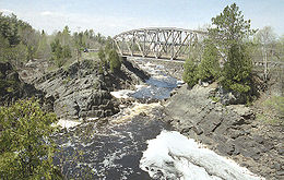
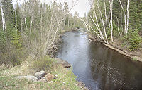
Saint Louis River
Encyclopedia
Minnesota
Minnesota is a U.S. state located in the Midwestern United States. The twelfth largest state of the U.S., it is the twenty-first most populous, with 5.3 million residents. Minnesota was carved out of the eastern half of the Minnesota Territory and admitted to the Union as the thirty-second state...
and Wisconsin
Wisconsin
Wisconsin is a U.S. state located in the north-central United States and is part of the Midwest. It is bordered by Minnesota to the west, Iowa to the southwest, Illinois to the south, Lake Michigan to the east, Michigan to the northeast, and Lake Superior to the north. Wisconsin's capital is...
that flows into Lake Superior
Lake Superior
Lake Superior is the largest of the five traditionally-demarcated Great Lakes of North America. It is bounded to the north by the Canadian province of Ontario and the U.S. state of Minnesota, and to the south by the U.S. states of Wisconsin and Michigan. It is the largest freshwater lake in the...
. The largest U.S. river to flow into the lake, it is 179 miles (288 kilometers) in length
Length
In geometric measurements, length most commonly refers to the longest dimension of an object.In certain contexts, the term "length" is reserved for a certain dimension of an object along which the length is measured. For example it is possible to cut a length of a wire which is shorter than wire...
and starts near Hoyt Lakes, Minnesota
Hoyt Lakes, Minnesota
Hoyt Lakes is a city in Saint Louis County, Minnesota, United States. The population was 2,017 at the 2010 census.County Highway 110 serves as a main arterial route in the community.-Geography:...
. The river's watershed
Drainage basin
A drainage basin is an extent or an area of land where surface water from rain and melting snow or ice converges to a single point, usually the exit of the basin, where the waters join another waterbody, such as a river, lake, reservoir, estuary, wetland, sea, or ocean...
is 3634 square miles (9,412 km²) in area
Area
Area is a quantity that expresses the extent of a two-dimensional surface or shape in the plane. Area can be understood as the amount of material with a given thickness that would be necessary to fashion a model of the shape, or the amount of paint necessary to cover the surface with a single coat...
. Near the Twin Ports of Duluth, Minnesota
Duluth, Minnesota
Duluth is a port city in the U.S. state of Minnesota and is the county seat of Saint Louis County. The fourth largest city in Minnesota, Duluth had a total population of 86,265 in the 2010 census. Duluth is also the second largest city that is located on Lake Superior after Thunder Bay, Ontario,...
and Superior, Wisconsin
Superior, Wisconsin
Superior is a city in and the county seat of Douglas County, Wisconsin, United States. The population was 26,960 at the 2010 census. Located at the junction of U.S. Highways 2 and 53, it is north of and adjacent to both the Village of Superior and the Town of Superior.Superior is at the western...
, the river becomes a freshwater estuary
Estuary
An estuary is a partly enclosed coastal body of water with one or more rivers or streams flowing into it, and with a free connection to the open sea....
.
According to Warren Upham
Warren Upham
Warren Upham was a geologist, archaeologist, and librarian who is best known for his studies of glacial Lake Agassiz. Upham worked as a geologist in New Hampshire before moving in 1879 to Minnesota to study the resources and glacial geology of that state...
, he records the Ojibwe
Ojibwe language
Ojibwe , also called Anishinaabemowin, is an indigenous language of the Algonquian language family. Ojibwe is characterized by a series of dialects that have local names and frequently local writing systems...
name of the river being Gichigami-ziibi (Great-lake River). He also records:
The river was probably so named by Pierre Gaultier de Varennes, sieur de La VérendryePierre Gaultier de Varennes, sieur de La VérendryePierre Gaultier de Varennes, sieur de La Vérendrye was a French Canadian military officer, fur trader and explorer. In the 1730s he and his four sons opened up the area west of Lake Superior and thus began the process that added Western Canada to the original New France in the Saint Lawrence basin...
(1685–1749), who was a very active explorer, in the years 1731 and onward, of the vast country from Pigeon RiverPigeon River (Minnesota-Ontario)The Pigeon River forms part of the US-Canada border between the State of Minnesota and the Province of Ontario west of Lake Superior. In pre-industrial times the river was a waterway of great importance for transportation and trade.-Geography:...
and Rainy LakeRainy LakeRainy Lake is a relatively large freshwater lake that straddles the border between the United States and Canada. The Rainy River issues from the west side of the lake and is harnessed to make hydroelectricity for US and Canadian locations. The U.S...
to the SaskatchewanSaskatchewan RiverThe Saskatchewan River is a major river in Canada, approximately long, flowing roughly eastward across Saskatchewan and Manitoba to empty into Lake Winnipeg...
and Missouri RiverMissouri RiverThe Missouri River flows through the central United States, and is a tributary of the Mississippi River. It is the longest river in North America and drains the third largest area, though only the thirteenth largest by discharge. The Missouri's watershed encompasses most of the American Great...
s, establishing trading posts and missions. The king of France in 1749, shortly before the death of La Vérendrye, conferred on him the cross of St. Louis as a recognition of the importance of his discoveries, and thence the name of the St. Louis River appears to have come. On Jean-Baptiste-Louis FranquelinJean-Baptiste-Louis FranquelinJean-Baptiste-Louis Franquelin was born at Saint-Michel de Villebernin, France in 1651. He died in France around 1712. He was a cartographer, a royal hydrographer, and a teacher of navigation. He was also the first official cartographer in Canada....
's map (1688) and Philippe BuachePhilippe BuachePhilippe Buache was a French geographer.Buache was trained under the geographer Guillaume Delisle, whose daughter he married, and whom he succeeded in the Académie des sciences in 1730. Buache was nominated first geographer of the king in 1729. He established the division of the world by seas and...
's map (1754), it is called the Rivière du Fond du Lac, and the map by Gilles Robert de VaugondyRobert de VaugondyGilles Robert de Vaugondy , also known as Le Sieur or Monsieur Robert, and his son, Didier Robert de Vaugondy , were leading mapmakers in France during the 18th century....
(1755) and Jonathan CarverJonathan CarverJonathan Carver was an American explorer and writer. He was born in Weymouth, Massachusetts and then moved with his family to Canterbury, Connecticut. He later married Abigail Robbins and became a shoemaker. He is believed to have had seven children.In 1755 Carver joined the colonial militia at...
's map (1778) are the earliest to give the present name.
Paddle to the Sea
Paddle-to-the-Sea is a 1941 children's book, written and illustrated by American author/artist Holling C. Holling. It was recognized as a Caldecott Honor Book in 1942....
, illustrated the polluted state of the St. Louis River. By 1975, the river became an Environmental Protection Agency
United States Environmental Protection Agency
The U.S. Environmental Protection Agency is an agency of the federal government of the United States charged with protecting human health and the environment, by writing and enforcing regulations based on laws passed by Congress...
Area of Concern. The Western Lake Superior Sanitary District (WLSSD) was established in 1971 to address serious pollution problems in the lower St. Louis River Basin. WLSSD's regional wastewater treatment plant began operating in 1978. Within 2 years, fish populations rebounded and anglers began returning to the river. Through the 1980s and 1990s, additional cleanups took place, and the river is now significantly less polluted.
The river offers a wide variety of fishing opportunities including excellent Walleye, Northern Pike, Largemouth Bass, and Channel
Catfish. Other species of rough fish can be caught here. Attempts to introduce Sturgeon into the river are currently taking
place and if caught, are to be immediately returned. The River is also frequented by those travelling the Minnesota DNR
St. Louis River Water Trail, which features campsites and excellent angling opportunities.