
Glacial history of Minnesota
Encyclopedia
Midwestern United States
The Midwestern United States is one of the four U.S. geographic regions defined by the United States Census Bureau, providing an official definition of the American Midwest....
and much of Canada
Canada
Canada is a North American country consisting of ten provinces and three territories. Located in the northern part of the continent, it extends from the Atlantic Ocean in the east to the Pacific Ocean in the west, and northward into the Arctic Ocean...
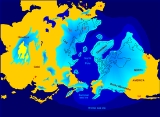
were covered at one time or another with an ice sheet
Ice sheet
An ice sheet is a mass of glacier ice that covers surrounding terrain and is greater than 50,000 km² , thus also known as continental glacier...
. This continental glacier
Glacier
A glacier is a large persistent body of ice that forms where the accumulation of snow exceeds its ablation over many years, often centuries. At least 0.1 km² in area and 50 m thick, but often much larger, a glacier slowly deforms and flows due to stresses induced by its weight...
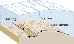
had a profound effect on the surface features of the area over which it moved. Vast quantities of rock and soil were scraped from the glacial centers to its margins by slowly moving ice and redeposited as drift
Drift (geology)
In geology, drift is the name for all material of glacial origin found anywhere on land or at sea , including sediment and large rocks...
or till
Till
thumb|right|Closeup of glacial till. Note that the larger grains in the till are completely surrounded by the matrix of finer material , and this characteristic, known as matrix support, is diagnostic of till....
. Much of this drift was dumped into old preglacial river valleys, while some of it was heaped into belts of hills (terminal moraine
Terminal moraine
A terminal moraine, also called end moraine, is a moraine that forms at the end of the glacier called the snout.Terminal moraines mark the maximum advance of the glacier. An end moraine is at the present boundary of the glacier....
s) at the margin of the glacier. The chief result of glaciation has been the modification of the preglacial topography
Topography
Topography is the study of Earth's surface shape and features or those ofplanets, moons, and asteroids...
by the deposition of drift over the countryside. However, continental glaciers possess great power of erosion and may actually modify the preglacial land surface by scouring and abrading rather than by the deposition of the drift.
The marks of glaciation vastly altered the topography of Minnesota
Minnesota
Minnesota is a U.S. state located in the Midwestern United States. The twelfth largest state of the U.S., it is the twenty-first most populous, with 5.3 million residents. Minnesota was carved out of the eastern half of the Minnesota Territory and admitted to the Union as the thirty-second state...
. Probably the most significant change was in the character and extent of the drainage
Drainage
Drainage is the natural or artificial removal of surface and sub-surface water from an area. Many agricultural soils need drainage to improve production or to manage water supplies.-Early history:...
. In preglacial times, there is reason to believe that most of the rain
Rain
Rain is liquid precipitation, as opposed to non-liquid kinds of precipitation such as snow, hail and sleet. Rain requires the presence of a thick layer of the atmosphere to have temperatures above the melting point of water near and above the Earth's surface...
water or meltwater from snow was quickly carried back to the ocean. Today, much of the precipitation is retained temporarily on the surface in the lake
Lake
A lake is a body of relatively still fresh or salt water of considerable size, localized in a basin, that is surrounded by land. Lakes are inland and not part of the ocean and therefore are distinct from lagoons, and are larger and deeper than ponds. Lakes can be contrasted with rivers or streams,...
s. Streams meander
Meander
A meander in general is a bend in a sinuous watercourse. A meander is formed when the moving water in a stream erodes the outer banks and widens its valley. A stream of any volume may assume a meandering course, alternately eroding sediments from the outside of a bend and depositing them on the...
from lake to lake, and only part of the total precipitation is carried away by the rivers. Such topography could be described as immature because the streams have not yet been able to establish themselves into a network that quickly and efficiently drains the land. The Mississippi River
Mississippi River
The Mississippi River is the largest river system in North America. Flowing entirely in the United States, this river rises in western Minnesota and meanders slowly southwards for to the Mississippi River Delta at the Gulf of Mexico. With its many tributaries, the Mississippi's watershed drains...
has cut a deep valley below St. Anthony Falls
Saint Anthony Falls
Saint Anthony Falls, or the Falls of Saint Anthony, located northeast of downtown Minneapolis, Minnesota, was the only natural major waterfall on the Upper Mississippi River. The natural falls was replaced by a concrete overflow spillway after it partially collapsed in 1869...
, but even the waters of this large river do not flow freely to the ocean because of Lake Pepin
Lake Pepin
Lake Pepin is a naturally occurring lake, and the widest naturally occurring part of the Mississippi River, located approximately 60 miles downstream from Saint Paul, Minnesota. It is a widening of the river on the border between Minnesota and Wisconsin. The formation of the lake was caused by the...
, which acts as a storage basin for some of the water. Streams have been actively engaged in their erosive work only for the last 10,000 years, the estimated length of time since the last glacier began its final retreat. This time span is relatively insignificant compared to the long history of the Earth
Earth
Earth is the third planet from the Sun, and the densest and fifth-largest of the eight planets in the Solar System. It is also the largest of the Solar System's four terrestrial planets...
.
Sequence of glacial events
The ice moved into Minnesota at different times from three glacial centers, the Labradorian center in northern Quebec
Quebec
Quebec or is a province in east-central Canada. It is the only Canadian province with a predominantly French-speaking population and the only one whose sole official language is French at the provincial level....
and Labrador
Labrador
Labrador is the distinct, northerly region of the Canadian province of Newfoundland and Labrador. It comprises the mainland portion of the province, separated from the island of Newfoundland by the Strait of Belle Isle...
; the Patrician center, just southwest of Hudson Bay
Hudson Bay
Hudson Bay , sometimes called Hudson's Bay, is a large body of saltwater in northeastern Canada. It drains a very large area, about , that includes parts of Ontario, Quebec, Saskatchewan, Alberta, most of Manitoba, southeastern Nunavut, as well as parts of North Dakota, South Dakota, Minnesota,...
; and the Keewatin center, northwest of Hudson Bay.
Deposits left by the continental ice sheets advancing from these three centers reflect the characteristics of the rocks over which they passed. The Keewatin ice encountered the Cretaceous
Cretaceous
The Cretaceous , derived from the Latin "creta" , usually abbreviated K for its German translation Kreide , is a geologic period and system from circa to million years ago. In the geologic timescale, the Cretaceous follows the Jurassic period and is followed by the Paleogene period of the...
limestones and shales of Manitoba
Manitoba
Manitoba is a Canadian prairie province with an area of . The province has over 110,000 lakes and has a largely continental climate because of its flat topography. Agriculture, mostly concentrated in the fertile southern and western parts of the province, is vital to the province's economy; other...
and the Red River Valley
Red River Valley
The Red River Valley is a region in central North America that is drained by the Red River of the North. It is significant in the geography of North Dakota, Minnesota, and Manitoba for its relatively fertile lands and the population centers of Fargo, Moorhead, Grand Forks, and Winnipeg...
, whereas the Patrician and Labradorian ice moved over iron-rich Pre-Cambrian
Precambrian
The Precambrian is the name which describes the large span of time in Earth's history before the current Phanerozoic Eon, and is a Supereon divided into several eons of the geologic time scale...
crystalline rocks of the Canadian Shield
Canadian Shield
The Canadian Shield, also called the Laurentian Plateau, or Bouclier Canadien , is a vast geological shield covered by a thin layer of soil that forms the nucleus of the North American or Laurentia craton. It is an area mostly composed of igneous rock which relates to its long volcanic history...
.
Pre-Wisconsinan glaciation
There are few areas in which the earlier drifts from the glacial deposits of the Pre-Illionian or Illinoian stages are exposed at the surface. have extensive areas of pre-Wisconsin drifts, but they are masked almost everywhere by surficial covering of loessLoess
Loess is an aeolian sediment formed by the accumulation of wind-blown silt, typically in the 20–50 micrometre size range, twenty percent or less clay and the balance equal parts sand and silt that are loosely cemented by calcium carbonate...
(wind-blown silt). Furthermore, these regions of older drift are maturely drained, because the streams have had a longer time to evolve into an efficient drainage system compared with the streams flowing in areas covered by younger glacial deposits. Howard Hobbs has proposed that the Pre-Illinoian glacial deposits in southwestern Minnesota are actually younger Illinoian glacial deposits.
Changes in the course of continental rivers
As the ice sheets moved into the central portion of North AmericaNorth America
North America is a continent wholly within the Northern Hemisphere and almost wholly within the Western Hemisphere. It is also considered a northern subcontinent of the Americas...
, the rivers that used to flow from the Rocky Mountains
Rocky Mountains
The Rocky Mountains are a major mountain range in western North America. The Rocky Mountains stretch more than from the northernmost part of British Columbia, in western Canada, to New Mexico, in the southwestern United States...
to the northeast into the Arctic Ocean
Arctic Ocean
The Arctic Ocean, located in the Northern Hemisphere and mostly in the Arctic north polar region, is the smallest and shallowest of the world's five major oceanic divisions...
found their valleys choked with ice. The rivers had to divert around the farthest extensions of the ice. When the ice retreated, the new valleys eroded into the landscape kept the rivers from moving back to their old positions.
Wisconsinan Glaciation
The Wisconsin glacial episode, the most recent glacial periodGlacial period
A glacial period is an interval of time within an ice age that is marked by colder temperatures and glacier advances. Interglacials, on the other hand, are periods of warmer climate within an ice age...
, has been subdivided into four substages, each representing an advance and retreat of the ice. The substages, named from the oldest to the youngest, are the Iowan, Tazewell, Cary and Mankato. Only the Iowan, Cary and Mankato are recognized in Minnesota, but studies indicate that the Tazewell drift may be present in southwestern Minnesota.
The Iowan drift occurs extensively at the surface only in southwestern and southeastern Minnesota, and contains few, if any, lakes because of the relatively mature surface drainage. The Tazewell drift in the southwestern Minnesota is devoid of lakes; in fact, the criterion of drainage was used by Robert Ruhe to distinguish Tazewell from Cary drifts.
Nearly all of the lakes in Minnesota are found within the borders of the Cary and Mankato drifts. For this reason, it is necessary to consider in some detail the nature and distribution of these two drift sheets.
Cary substage
The glaciers that advanced out of the northeastern portion of Canada were of sufficient thickness to produce significant erosion in northeastern Minnesota. Because the affected area reached somewhat south of Minneapolis, MinnesotaMinneapolis, Minnesota
Minneapolis , nicknamed "City of Lakes" and the "Mill City," is the county seat of Hennepin County, the largest city in the U.S. state of Minnesota, and the 48th largest in the United States...
, it is called the "Minneapolis lobe" The Minneapolis lobe is characteristically red and sandy because of red sandstone
Sandstone
Sandstone is a sedimentary rock composed mainly of sand-sized minerals or rock grains.Most sandstone is composed of quartz and/or feldspar because these are the most common minerals in the Earth's crust. Like sand, sandstone may be any colour, but the most common colours are tan, brown, yellow,...
and shale source rocks to the north and northeast; it may be recognized as well by pebbles of basalt
Basalt
Basalt is a common extrusive volcanic rock. It is usually grey to black and fine-grained due to rapid cooling of lava at the surface of a planet. It may be porphyritic containing larger crystals in a fine matrix, or vesicular, or frothy scoria. Unweathered basalt is black or grey...
, gabbro
Gabbro
Gabbro refers to a large group of dark, coarse-grained, intrusive mafic igneous rocks chemically equivalent to basalt. The rocks are plutonic, formed when molten magma is trapped beneath the Earth's surface and cools into a crystalline mass....
, red syenite
Syenite
Syenite is a coarse-grained intrusive igneous rock of the same general composition as granite but with the quartz either absent or present in relatively small amounts Syenite is a coarse-grained intrusive igneous rock of the same general composition as granite but with the quartz either absent or...
, felsite
Felsite
Felsite is a very fine grained volcanic rock that may or may not contain larger crystals. Felsite is a field term for a light colored rock that typically requires petrographic examination or chemical analysis for more precise definition...
and iron
Iron
Iron is a chemical element with the symbol Fe and atomic number 26. It is a metal in the first transition series. It is the most common element forming the planet Earth as a whole, forming much of Earth's outer and inner core. It is the fourth most common element in the Earth's crust...
formation from northeastern Minnesota.
Ground moraine with uncharacteristic reddish iron-rich sediments extended from St. Cloud, Minnesota
St. Cloud, Minnesota
St. Cloud is a city in the U.S. state of Minnesota and the largest population center in the state's central region. The population was 65,842 at the 2010 census. It is the county seat of Stearns County...
, back northeastward. The glaciers produced a set of terminal moraines which extend from northwest of St. Cloud into the Twin Cities and up into central Wisconsin
Wisconsin
Wisconsin is a U.S. state located in the north-central United States and is part of the Midwest. It is bordered by Minnesota to the west, Iowa to the southwest, Illinois to the south, Lake Michigan to the east, Michigan to the northeast, and Lake Superior to the north. Wisconsin's capital is...
. They deposited reddish sands and gravels westward and southward in outwash plains
Sandur
A sandur is a glacial outwash plain formed of sediments deposited by meltwater at the terminus of a glacier.- Formation :Sandar are found in glaciated areas, such as Svalbard, Kerguelen Islands, and Iceland...
.
Mankato substage
With the retreat of the Patrician ice, the stage was set for the final phase of the Wisconsinan glaciation in Minnesota. The last major advance of the continental glacier in Minnesota culminated in a lobe that reached as far south as Des Moines, Iowa. The glacial movement from the northwest was from a more distant source than ice from the northwest. The subsequent glacier that moved into Minnesota was quite thin and unable to cause much erosion. The Des Moines lobe produced a northeast-moving projection known as the Gratsburgh sublobe. Also protruding from the main Keewatin ice sheet was the St. Louis sublobe. The drift of these ice lobes is generally in late Wisconsinan time. The sediment transportSediment transport
Sediment transport is the movement of solid particles , typically due to a combination of the force of gravity acting on the sediment, and/or the movement of the fluid in which the sediment is entrained...
ed by the Mankato glacier is colored tan to buff and is clay-rich and calcareous because of shale and limestone source rocks to the northwest. The Superior lobe also developed during Mankato time and advanced as far west as Aitkin County, Minnesota
Aitkin County, Minnesota
Aitkin County is a county located in the U.S. state of Minnesota. As of 2010, the population is 16,202. Its county seat is Aitkin. A portion of the Mille Lacs Indian Reservation is in the county.-History:...
.
The Grantsburg sublobe effectively blocked the drainage of the Mississippi River
Mississippi River
The Mississippi River is the largest river system in North America. Flowing entirely in the United States, this river rises in western Minnesota and meanders slowly southwards for to the Mississippi River Delta at the Gulf of Mexico. With its many tributaries, the Mississippi's watershed drains...
from north of St. Cloud southeastward through the Twin Cities. The outwash
Sandur
A sandur is a glacial outwash plain formed of sediments deposited by meltwater at the terminus of a glacier.- Formation :Sandar are found in glaciated areas, such as Svalbard, Kerguelen Islands, and Iceland...
carrying large quantities of sand was diverted overland to the east around the sublobe. No true drainage valley was produced; instead, multiple small streams flowed toward the northeast depositing their overloads of sand as they went. This produced a roughly triangular sandy outwash region called the Anoka Sand Plain, reaching from St. Cloud to the Twin Cities up to the northeast to Grantsburg, Wisconsin
Grantsburg, Wisconsin
Grantsburg is a village in Burnett County in the U.S. state of Wisconsin. The population was 1,369 at the 2000 census. The village is located within the Town of Grantsburg.-Claim to fame:...
.
Kettle lakes
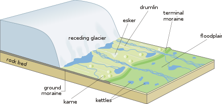
Kettle lakes may be formed within the ground moraine region behind the terminal moraine
Terminal moraine
A terminal moraine, also called end moraine, is a moraine that forms at the end of the glacier called the snout.Terminal moraines mark the maximum advance of the glacier. An end moraine is at the present boundary of the glacier....
s. They can be of any size and their shorelines can be composed of anything from clay to sand to boulders. In a terminal moraine region, the kettles are fairly small but deep, to fit between the moraine's steep and hilly ridges. If the ice had advanced outward and then retreated leaving behind an outwash
Sandur
A sandur is a glacial outwash plain formed of sediments deposited by meltwater at the terminus of a glacier.- Formation :Sandar are found in glaciated areas, such as Svalbard, Kerguelen Islands, and Iceland...
, kettles may have formed. Outwash kettle lakes are usually shallow and their numbers are much smaller than in other glaciated regions. The abundant sand quickly can fill in the depressions and composes most of the beaches of these lakes.
Because Minnesota has had glacial movements into the state from both the northeast and northwest, the landscape has been modified by overlapping glacial regions. An outwash plain of Cary age may have a newer cover of ground moraine of Mankato age. A Cary ground moraine may have been subsequently covered over by Mankato outwash.
The majority of lakes in the world are kettle lakes produced by glacial activity. In Minnesota, the majority of kettles lakes reside in ground moraine and terminal moraine areas.
Bedrock erosion lakes
In northeastern of Minnesota the glaciers were thousands of feet thick. As the glaciers moved through the area they eroded large quantities of rock away. Ice itself is not very abrasive, but by picking up and moving pieces of rock it was able to scrape away softer underlying materials. Volcanic rocks underlie the area. Along the Rove region of the Arrowhead RegionArrowhead Region
The Arrowhead Region is located in the northeastern part of the U.S. state of Minnesota, so called because of its pointed shape. The predominantly rural region encompasses of land area and comprises Carlton, Cook, Lake and St. Louis Counties. Its population at the 2000 census was 248,425 residents...
, there are multiple tilted layers of volcanic rocks interspersed with layers of shale; the shalelayers are softer than the volcanic basalt. As the glaciers eroded the materials, the shales were removed. The topography in the Rove region alternates hills (composed of diabase) and valleys (former shale layers); these hills and valley orient in a west to east direction. Many of these valleys are now lakes. Because the lakes are oriented west-east, visitors to the Rove region think that the ice moved in an east-west direction. Glacial striations (scratches) show that the ice moved from north-to-south, perpendicular to the orientation of the lakebeds themselves.
Adjacent to the Rove area Lake Superior
Lake Superior
Lake Superior is the largest of the five traditionally-demarcated Great Lakes of North America. It is bounded to the north by the Canadian province of Ontario and the U.S. state of Minnesota, and to the south by the U.S. states of Wisconsin and Michigan. It is the largest freshwater lake in the...
's basin resides in a billion-year-old trough which was caused by the Midcontinet Rift. Preglacially the depression had been filled with eroded shales. The thousands of feet of glacial ice eroded away a large amount of the shale. The ice was so thick that it scoured the sandstone down to depths of 700 feet (210 m) below sea level. The present Lake Superior is the single largest freshwater lake in area in the world.
Glacial lakes
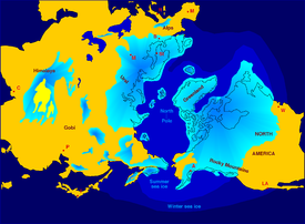
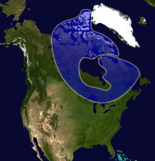
About 18,000 years ago, the Laurentide Ice SheetLaurentide ice sheet
The Laurentide Ice Sheet was a massive sheet of ice that covered hundreds of thousands of square miles, including most of Canada and a large portion of the northern United States, multiple times during Quaternary glacial epochs. It last covered most of northern North America between c. 95,000 and...
began to melt and retreat. As the Mankato ice shrank meltwaters became ponded in several places along the margin of the glacier. Some of these lakes covered several hundred thousand square miles and have left a definite imprint on the topography
Topography
Topography is the study of Earth's surface shape and features or those ofplanets, moons, and asteroids...
. All of them have since been drained by natural force or have been shrunk considerably from their original size.
Glacial Lake Duluth
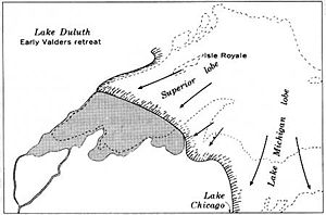
Glacial Lake Duluth
Glacial Lake Duluth was a proglacial lake that formed in the Lake Superior drainage basin as the Laurentide ice sheet retreated. The oldest existing shorelines were formed after retreat from the Greatlakean advance, sometime around 11,000 years B.P. Lake Duluth formed at the western end of the Lake...
is the body of water that formed at the southwestern margin of the Superior lobe and occupied a much larger area than the present Lake Superior
Lake Superior
Lake Superior is the largest of the five traditionally-demarcated Great Lakes of North America. It is bounded to the north by the Canadian province of Ontario and the U.S. state of Minnesota, and to the south by the U.S. states of Wisconsin and Michigan. It is the largest freshwater lake in the...
. Its shorelines stood nearly 500 feet (150 m) above sea level of its modern successor, Lake Superior. During its early history Lake Duluth drained into the Mississippi River down the St. Croix River
St. Croix River (Wisconsin-Minnesota)
The St. Croix River is a tributary of the Mississippi River, approximately long, in the U.S. states of Wisconsin and Minnesota. The lower of the river form the border between Wisconsin and Minnesota. The river is a National Scenic Riverway under the protection of the National Park Service. A...
Valley. There were two outlets, one along the Kettle
Kettle River (Minnesota)
The Kettle is a tributary of the St. Croix River, about 80 mi long, in eastern Minnesota in the United States. Via the St. Croix River, it is part of the watershed of the Mississippi River. The river's English name is due to the large number of large rounded holes in the sandstone in and around...
and Nemadji River
Nemadji River
The Nemadji River is a river rising in Pine County, Minnesota, United States, which flows through Carlton County, Minnesota and Douglas County, Wisconsin to Lake Superior...
s in Minnesota and another to the east along the Bois Brule River
Bois Brule River
The Bois Brule River is a river situated in Douglas County, Wisconsin, near its eastern border with Bayfield County. The river, which is 44 miles long, rises in central Douglas County near Upper St...
in Wisconsin. Later, however, when the Superior lobe had retreated farther to the northeast, the waters of Lake Duluth merged those in the Michigan and Huron basins, and the southern outlets were abandoned in favor of a lower one on the east end of Lake Superior. The Kettle River no longer drains Lake Superior, but resides in a large valley, which itself could not have produced with its present discharge. The Nemadji and Bois Brule Rivers actually flow northward toward Lake Superior through the eastern proglacial outlet. Even though vast amounts of water flowed over the southern rim of Lake Superior, the Bois Brule River outlet was never scoured deep enough to remove a continental divide
Continental divide
A continental divide is a drainage divide on a continent such that the drainage basin on one side of the divide feeds into one ocean or sea, and the basin on the other side either feeds into a different ocean or sea, or else is endorheic, not connected to the open sea...
at the Bois Brule River's headwaters
Source (river or stream)
The source or headwaters of a river or stream is the place from which the water in the river or stream originates.-Definition:There is no universally agreed upon definition for determining a stream's source...
.
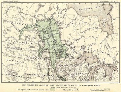
Glacial Lake Agassiz
Proglacial lake
In geology, a proglacial lake is a lake formed either by the damming action of a moraine or ice dam during the retreat of a melting glacier, or by meltwater trapped against an ice sheet due to isostatic depression of the crust around the ice...
s was Lake Agassiz
Lake Agassiz
Lake Agassiz was an immense glacial lake located in the center of North America. Fed by glacial runoff at the end of the last glacial period, its area was larger than all of the modern Great Lakes combined, and it held more water than contained by all lakes in the world today.-Conception:First...
, a small part of which occupied the present Red River Valley
Red River Valley
The Red River Valley is a region in central North America that is drained by the Red River of the North. It is significant in the geography of North Dakota, Minnesota, and Manitoba for its relatively fertile lands and the population centers of Fargo, Moorhead, Grand Forks, and Winnipeg...
of Minnesota and North Dakota
North Dakota
North Dakota is a state located in the Midwestern region of the United States of America, along the Canadian border. The state is bordered by Canada to the north, Minnesota to the east, South Dakota to the south and Montana to the west. North Dakota is the 19th-largest state by area in the U.S....
. Glaciers to the north blocked the natural northward drainage of the areas. As the ice melted, a proglacial lake developed southward of the ice. The water overflowed the continental divide at Browns Valley, Minnesota
Browns Valley, Minnesota
As of the census of 2000, there were 690 people, 285 households, and 171 families residing in the city. The population density was 878.5 people per square mile . There were 317 housing units at an average density of 403.6 per square mile...
; drained through the Traverse Gap
Traverse Gap
The Traverse Gap is an ancient river channel occupied by Lake Traverse and Big Stone Lake and the valley connecting them at Browns Valley, Minnesota. It is located on the border of the U.S. states of Minnesota and South Dakota...
and cut the present Minnesota River
Minnesota River
The Minnesota River is a tributary of the Mississippi River, approximately 332 miles long, in the U.S. state of Minnesota. It drains a watershed of nearly , in Minnesota and about in South Dakota and Iowa....
valley. The amount of discharge was staggering. It helped the adjacent Mississippi River to form a very large valley in the southeastern Minnesota.
The river that drained from Lake Agassiz is called the Glacial River Warren
Glacial River Warren
right|thumb|210px|The course of the Minnesota River follows the valley carved by Glacial River WarrenGlacial River Warren or River Warren was a prehistoric river that drained Lake Agassiz in central North America between 11,700 and 9,400 years ago...
. It flowed over the top of a recessional moraine at Browns Valley. As the water eroded away, the glacial deposits the level in the lake dropped. Eventually enough large boulders were left behind that a boulder pavement was produced, which inhibited further downward cutting. The lake level was thus stabilized for a while. During the few decades when the level was constant, waves on the lake produced noticeable beaches along the shoreline. Glacial outwash was also being deposited on the bottom of the lake. Eventually the boulders at the lake outlet were eroded downstream and the river then could erode downward through a mix of sediment sizes. Again, a boulder pavement formed and, as before, the lake level stabilized at a lower level, again forming another set of beaches.
After further retreat of the ice into Canada
Canada
Canada is a North American country consisting of ten provinces and three territories. Located in the northern part of the continent, it extends from the Atlantic Ocean in the east to the Pacific Ocean in the west, and northward into the Arctic Ocean...
, lower outlets were uncovered to Hudson Bay, and the Minnesota Valley outlet was abandoned. The continental divide at Browns Valley become the headwaters for the north flowing Red River of the North
Red River of the North
The Red River is a North American river. Originating at the confluence of the Bois de Sioux and Otter Tail rivers in the United States, it flows northward through the Red River Valley and forms the border between the U.S. states of Minnesota and North Dakota before continuing into Manitoba, Canada...
and southeast flowing tributary of the Mississippi River, the Minnesota River
Minnesota River
The Minnesota River is a tributary of the Mississippi River, approximately 332 miles long, in the U.S. state of Minnesota. It drains a watershed of nearly , in Minnesota and about in South Dakota and Iowa....
.
During its existence, Lake Agassiz may have been the largest freshwater lake to ever have existed. The lakebed composed of lake muds and silts is one of the flattest regions of Earth and is extremely fertile. No bedrock erosion lakes exist there because the ice was too thin to erode. No kettle lakes are found on the lakebed because lakebed deposits would have filled their depressions.
See also
- Quaternary glaciationQuaternary glaciationQuaternary glaciation, also known as the Pleistocene glaciation, the current ice age or simply the ice age, refers to the period of the last few million years in which permanent ice sheets were established in Antarctica and perhaps Greenland, and fluctuating ice sheets have occurred elsewhere...
- Illinoian StageIllinoian StageThe Illinoian Stage is the name used by Quaternary geologists in North America to designate the period of geologic time of ~300,000—130,000 years ago, a period of ~ during the middle Pleistocene when sediments comprising the Illinoian Glacial Lobe were deposited. It precedes the Sangamonian stage...
- Laurentide ice sheetLaurentide ice sheetThe Laurentide Ice Sheet was a massive sheet of ice that covered hundreds of thousands of square miles, including most of Canada and a large portion of the northern United States, multiple times during Quaternary glacial epochs. It last covered most of northern North America between c. 95,000 and...
- PleistocenePleistoceneThe Pleistocene is the epoch from 2,588,000 to 11,700 years BP that spans the world's recent period of repeated glaciations. The name pleistocene is derived from the Greek and ....
- Last glacial period
External links
- Minnesota glaciation by the Minnesota River Basin Data Center.
- Minnesota valley formation by the Minnesota River Basin Data Center.
- Geology of Minnesota by the Minnesota Department of Natural ResourcesMinnesota Department of Natural ResourcesThe Minnesota Department of Natural Resources is the agency of the U.S. state of Minnesota charged with conserving and managing the state's natural resources. The agency maintains areas such as state parks, state forests, recreational trails, and recreation areas as well as managing minerals,...
. (Cached version.) - Geological and glacial history of Minnesota by the Minnesota Geological Survey.
- Glaciers in Minnesota by Minnesota Guidebook to State Agency Services.
- "Glaciers Left Their Mark on the Mississippi River" by Ruth Nissen.
- Minnesota Prehistory by S.L. Burgstahler.