

Paramushir
Encyclopedia
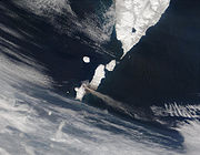
Paramushir is a volcanic island in the northern portion of Kuril Islands
chain in the Sea of Okhotsk
in the northwest Pacific Ocean
. It is separated from Shumshu
by the very narrow Second Kuril Strait
in the northeast 2.5 kilometres (1.6 mi), from Antsiferov by the Luzhin Strait (15 km) to the southwest, from Atlasov in the northwest by 20 kilometres (12.4 mi), and from Onnekotan in the south by the 40 km wide Fourth Kuril Strait
. Its northern tip is 39 kilometres (24.2 mi) from Cape Lopatka
at the southern tip of the Kamchatka Peninsula. Its name is derived from the Ainu language
, from “broad island” or “populous island”. Severo-Kurilsk
, the administrative center of the Severo-Kurilsky district, is the only permanently populated settlement on Paramushir island.
 Paramushir is roughly rectangular, and is the second largest of the Kurile Islands with an area of 2053 square kilometres (792.7 sq mi).
Geologically, Paramushir is a continuous chain of 23 volcanoes. At least five of them are active, and exceed 1000 metres (3,280.8 ft):
Paramushir has a sub-arctic climate strongly modulated by the cooling effects of the North Pacific Oyashio Current
. The arboreal flora of Paramushir is consequently limited to dense, stunted copses of Siberian dwarf pine
and shrubby alder
. The alpine tundra
which dominates the landscape produces plentiful edible mushrooms and berries, especially lingonberry, Arctic raspberry
, whortleberry and crowberry
. Red fox
, Arctic hare
and ermine
are notably abundant and hunted by the inhabitants. The island also supports a population of grizzly bear
s. The straits between Paramushir and Shumshu island support a notably dense population of sea otters and harbor seals are similarly common.
Several species of charr
and Pacific salmon spawn in its rivers, notably in the Tukharka river, which at 20 kilometres (12.4 mi) is the longest river on the island.
at the time of European contact. The island appears on an official map showing the territories of Matsumae Domain
, a feudal domain of Edo period
Japan
dated 1644, and Russian fur traders are known to have visited the island in 1711 and 1713, and Russian Orthodox missionaries established a church in 1747 to convert the local inhabitants. Subsequently claimed by the Empire of Russia, sovereignty
over the island was initially confirmed to be under Imperial Russia under the terms of the Treaty of Shimoda
in 1855, but was transferred to the Empire of Japan
per the Treaty of Saint Petersburg (1875) along with the rest of the Kurile Islands. The Japanese established a settlement, Kashiwabara, on the site of the largest Ainu village, which became the major port on the island, and a center for the commercial fishing
industry. The island was administered as part of Shimushu District of Nemuro Subprefecture
of Hokkaidō
.
During World War II
the island was strongly garrisoned by both the Imperial Japanese Army
and Imperial Japanese Navy
. The headquarters of the IJA 91st Infantry Division, responsible for defense of the northern Kuriles, was established at Kashiwabara, and numerous coastal artillery
positions and fortified bunkers were constructed in various locations around the island. In addition, the Imperial Japanese Army constructed four airfields: Kashiwabara Airfield in the northeast with Ki-43 Oscars, Kakumabestu Airfield on the southwest coast with a 3800 feet (1,158.2 m) runway and Ki-44 Tojo
s, Kitanodai Airfield on the northeast coast with a 4000 feet (1,219.2 m) runway, and Suribachi Airfield, an auxiliary base in the center of the south coast with two runways. The Imperial Japanese Navy had Musashi Airfield on the south-western tip of the island with two 4000 feet (1,219.2 m) runways, operating a variety of aircraft as well as a radar site. These bases were subject to sporadic air raid
s from the US Army Air Force and US Navy based in the Aleutian Islands from 1943 until the end of the war
.
During the Invasion of the Kuril Islands, Soviet
landed on Paramushir on August 18, 1945, and combat operations continued through August 23, ending with the surrender of the surviving members of the Japanese garrison. The Soviets forcibly deported the remaining Japanese civilian inhabitants and sent the prisoners of war to labor camps
. Kashiwabara was renamed Severo-Kurilsk
and the island annexed by the Soviet Union in 1946. Japan formally gave up sovereignty over the island under the terms of the San Francisco Peace Treaty of 1951.
In November 1952, Severo-Kurilsk was destroyed by the 1952 Severo-Kurilsk tsunami
and was rebuilt in another location. Following the dissolution of the Soviet Union
in 1990, the population of the island has decreased (2592 in 2002 census, 5180 in the 1989 census), and villages that once lined the coast are now ghost towns. This is due in part to the crash of the formerly lucrative herring
fishery, to the extremely destructive tsunami
of 1952, and general economic hardships in the more remote reaches of Russia since the fall of the Soviet Union. The island is now administered as part of the Sakhalin Oblast
of the Russian Federation.
Kuril Islands
The Kuril Islands , in Russia's Sakhalin Oblast region, form a volcanic archipelago that stretches approximately northeast from Hokkaidō, Japan, to Kamchatka, Russia, separating the Sea of Okhotsk from the North Pacific Ocean. There are 56 islands and many more minor rocks. It consists of Greater...
chain in the Sea of Okhotsk
Sea of Okhotsk
The Sea of Okhotsk is a marginal sea of the western Pacific Ocean, lying between the Kamchatka Peninsula on the east, the Kuril Islands on the southeast, the island of Hokkaidō to the far south, the island of Sakhalin along the west, and a long stretch of eastern Siberian coast along the west and...
in the northwest Pacific Ocean
Pacific Ocean
The Pacific Ocean is the largest of the Earth's oceanic divisions. It extends from the Arctic in the north to the Southern Ocean in the south, bounded by Asia and Australia in the west, and the Americas in the east.At 165.2 million square kilometres in area, this largest division of the World...
. It is separated from Shumshu
Shumshu
Shumshu , is the northernmost island of Kuril Islands chain in the Sea of Okhotsk in the northwest Pacific Ocean. The name of the island is derived from the Ainu language meaning “good island”. It is separated from Paramushir by the very narrow Second Kuril Strait in the northeast , its northern...
by the very narrow Second Kuril Strait
Second Kuril Strait
Second Kuril Strait is a strait located at , which separates islands of Paramushir and Shumshu in the Kuril Islands, Russia....
in the northeast 2.5 kilometres (1.6 mi), from Antsiferov by the Luzhin Strait (15 km) to the southwest, from Atlasov in the northwest by 20 kilometres (12.4 mi), and from Onnekotan in the south by the 40 km wide Fourth Kuril Strait
Fourth Kuril Strait
Fourth Kuril Strait is a strait, located at , separating islands of Onekotan and Paramushir in the Kuril Islands, Russia....
. Its northern tip is 39 kilometres (24.2 mi) from Cape Lopatka
Cape Lopatka
Cape Lopatka is the southernmost point of Kamchatka Peninsula, Russia, with the rural locality of Semenovka at its southernmost point. Cape Lopatka lies about north of Shumshu, the northernmost island of the Kuril Islands...
at the southern tip of the Kamchatka Peninsula. Its name is derived from the Ainu language
Ainu language
Ainu is one of the Ainu languages, spoken by members of the Ainu ethnic group on the northern Japanese island of Hokkaidō....
, from “broad island” or “populous island”. Severo-Kurilsk
Severo-Kurilsk
Severo-Kurilsk is a town in Sakhalin Oblast, Russia. It is situated in the northern part of the Kuril Islands, on the island of Paramushir. Population: 2,592 ; 5,180 .-History:...
, the administrative center of the Severo-Kurilsky district, is the only permanently populated settlement on Paramushir island.
Geography and natural history
Geologically, Paramushir is a continuous chain of 23 volcanoes. At least five of them are active, and exceed 1000 metres (3,280.8 ft):
- ChikurachkiChikurachkiChikurachki is the highest volcano on Paramushir Island in the northern Kuril islands, is actually a relatively small cone constructed on a high Pleistocene volcanic edifice. Oxidized andesitic scoria deposits covering the upper part of the young cone give it a distinctive red color...
, with a height of 1816 metres (5,958 ft) is the highest peak on Paramushir and the third highest in the Kurile Islands. It has erupted in 1690, 1853, 1859, 1933 and several times between 1957–2008. During the most recent eruption in August 2008, the volcanic ash reached the town of Severo-Kurilsk located 60 km north-east . The previous eruption took place on March 4, 2007, when a 1.5 km high plume of ash was emitted that trailed for several hundred kilometers into the neighboring waters.
- Fuss PeakFuss PeakFuss Peak is an active stratovolcano located on the southern end of Paramushir Island, Kuril Islands, Russia. Only one unambiguous eruption, in 1854, is known. Fuss Peak is still active....
, with a height of 1772 metres (5,813.6 ft) is a conical stratovolcanoStratovolcanoA stratovolcano, also known as a composite volcano, is a tall, conical volcano built up by many layers of hardened lava, tephra, pumice, and volcanic ash. Unlike shield volcanoes, stratovolcanoes are characterized by a steep profile and periodic, explosive eruptions...
. It has erupted in 1742, 1854 and 1933. - Lomonosov GroupLomonosov GroupLomonosov Group is a volcanic group of cinder cones located in the southern part of Paramushir Island, Kuril Islands, Russia.- References :*...
, with a height of 1681 metres (5,515.1 ft) is part of the Chikurachki group.
- Karpinsky GroupKarpinsky GroupKarpinsky Group is a volcanic group located at the southern end of Paramushir Island, Kuril Islands, Russia. The group is capped by two gently sloping cones rising to a height of 1345 m. They are composed of andesites and andesite-basalts. In the two craters there are fumaroles and fountains of...
, with a height of 1345 metres (4,412.7 ft) has erupted in 1957.
- EbekoEbekoEbeko is a highly active somma volcano located on the northern end of Paramushir Island, Kuril Islands, Russia. It is one of the most active volcanoes of the Kuril Islands.- References :*...
, with a height of 1345 metres (4,412.7 ft) has erupted numerous times, most recently in 1990. The central crater of Ebeko is filled by a caldera lake about 20 metres (65.6 ft) deep.
Paramushir has a sub-arctic climate strongly modulated by the cooling effects of the North Pacific Oyashio Current
Oyashio Current
, also known as Oya Siwo, Okhotsk or the Kurile current, is a cold subarctic ocean current that flows south and circulates counterclockwise in the western North Pacific Ocean. It collides with the Kuroshio Current off the eastern shore of Japan to form the North Pacific Current...
. The arboreal flora of Paramushir is consequently limited to dense, stunted copses of Siberian dwarf pine
Siberian Dwarf Pine
Pinus pumila is a native to northeastern Asia, including the islands of Japan. This shrubby pine ranges from 1–3 m in height, exceptionally up to 5 m, but may have individual branches that extend farther along the ground in length...
and shrubby alder
Alder
Alder is the common name of a genus of flowering plants belonging to the birch family . The genus comprises about 30 species of monoecious trees and shrubs, few reaching large size, distributed throughout the North Temperate Zone and in the Americas along the Andes southwards to...
. The alpine tundra
Alpine tundra
Alpine tundra is a natural region that does not contain trees because it is at high altitude. Alpine tundra is distinguished from arctic tundra, because alpine soils are generally better drained than arctic soils...
which dominates the landscape produces plentiful edible mushrooms and berries, especially lingonberry, Arctic raspberry
Arctic raspberry
The Arctic raspberry, Rubus arcticus, is a species of slow-growing bramble belonging to the rose family. Its dark red fruit is considered as a delicacy. In the Pacific Northwest it is sometimes called the nagoon or nagoonberry, a name which derives from the Tlingit neigóon...
, whortleberry and crowberry
Crowberry
Crowberry is a small genus of dwarf evergreen shrubs that bear edible fruit. They are commonly found in the northern hemisphere, from temperate to subarctic climates, and also in the Southern Andes of South America and on the South Atlantic islands of South Georgia, the Falklands and Tristan da...
. Red fox
Red Fox
The red fox is the largest of the true foxes, as well as being the most geographically spread member of the Carnivora, being distributed across the entire northern hemisphere from the Arctic Circle to North Africa, Central America, and the steppes of Asia...
, Arctic hare
Arctic Hare
The arctic hare , or polar rabbit is a species of hare which is adapted largely to polar and mountainous habitats. The arctic hare survives with a thick coat of fur and usually digs holes under the ground or snow to keep warm and sleep...
and ermine
Ermine
Ermine has several uses:* A common name for the stoat * The white fur and black tail end of this animal, which is historically worn by and associated with royalty and high officials...
are notably abundant and hunted by the inhabitants. The island also supports a population of grizzly bear
Grizzly Bear
The grizzly bear , also known as the silvertip bear, the grizzly, or the North American brown bear, is a subspecies of brown bear that generally lives in the uplands of western North America...
s. The straits between Paramushir and Shumshu island support a notably dense population of sea otters and harbor seals are similarly common.
Several species of charr
Salvelinus
Salvelinus is a genus of salmonid fish often called char or charr; some species are called "trout". Salvelinus is a member of the Salmoninae subfamily of the Salmonidae family. Charr may be identified by light cream pink or red spots over a darker body. Scales tend to be small, with 115-200 along...
and Pacific salmon spawn in its rivers, notably in the Tukharka river, which at 20 kilometres (12.4 mi) is the longest river on the island.
History
Paramushir was inhabited by the AinuAinu people
The , also called Aynu, Aino , and in historical texts Ezo , are indigenous people or groups in Japan and Russia. Historically they spoke the Ainu language and related varieties and lived in Hokkaidō, the Kuril Islands, and much of Sakhalin...
at the time of European contact. The island appears on an official map showing the territories of Matsumae Domain
Matsumae clan
The was a Japanese clan which was granted the area around Matsumae, Hokkaidō as a march fief in 1590 by Toyotomi Hideyoshi, and charged with defending it, and by extension all of Japan, from the Ainu 'barbarians' to the north. The clan was originally known as the Kakizaki clan who settled...
, a feudal domain of Edo period
Edo period
The , or , is a division of Japanese history which was ruled by the shoguns of the Tokugawa family, running from 1603 to 1868. The political entity of this period was the Tokugawa shogunate....
Japan
Japan
Japan is an island nation in East Asia. Located in the Pacific Ocean, it lies to the east of the Sea of Japan, China, North Korea, South Korea and Russia, stretching from the Sea of Okhotsk in the north to the East China Sea and Taiwan in the south...
dated 1644, and Russian fur traders are known to have visited the island in 1711 and 1713, and Russian Orthodox missionaries established a church in 1747 to convert the local inhabitants. Subsequently claimed by the Empire of Russia, sovereignty
Sovereignty
Sovereignty is the quality of having supreme, independent authority over a geographic area, such as a territory. It can be found in a power to rule and make law that rests on a political fact for which no purely legal explanation can be provided...
over the island was initially confirmed to be under Imperial Russia under the terms of the Treaty of Shimoda
Treaty of Shimoda
The Treaty of Shimoda of 1855, formally Treaty of Commerce and Navigation between Japan and Russia , was signed between the Russian Vice-Admiral Euphimy Vasil'evich Putiatin and Toshiakira Kawaji of Japan in the city of Shimoda, Izu Province, Japan, on February 7, 1855...
in 1855, but was transferred to the Empire of Japan
Empire of Japan
The Empire of Japan is the name of the state of Japan that existed from the Meiji Restoration on 3 January 1868 to the enactment of the post-World War II Constitution of...
per the Treaty of Saint Petersburg (1875) along with the rest of the Kurile Islands. The Japanese established a settlement, Kashiwabara, on the site of the largest Ainu village, which became the major port on the island, and a center for the commercial fishing
Commercial fishing
Commercial fishing is the activity of catching fish and other seafood for commercial profit, mostly from wild fisheries. It provides a large quantity of food to many countries around the world, but those who practice it as an industry must often pursue fish far into the ocean under adverse conditions...
industry. The island was administered as part of Shimushu District of Nemuro Subprefecture
Nemuro Subprefecture
is a subprefecture of Hokkaidō, Japan. The Japanese claim the disputed Southern Kurile Islands as part of this subprefecture....
of Hokkaidō
Hokkaido
, formerly known as Ezo, Yezo, Yeso, or Yesso, is Japan's second largest island; it is also the largest and northernmost of Japan's 47 prefectural-level subdivisions. The Tsugaru Strait separates Hokkaido from Honshu, although the two islands are connected by the underwater railway Seikan Tunnel...
.
During World War II
World War II
World War II, or the Second World War , was a global conflict lasting from 1939 to 1945, involving most of the world's nations—including all of the great powers—eventually forming two opposing military alliances: the Allies and the Axis...
the island was strongly garrisoned by both the Imperial Japanese Army
Imperial Japanese Army
-Foundation:During the Meiji Restoration, the military forces loyal to the Emperor were samurai drawn primarily from the loyalist feudal domains of Satsuma and Chōshū...
and Imperial Japanese Navy
Imperial Japanese Navy
The Imperial Japanese Navy was the navy of the Empire of Japan from 1869 until 1947, when it was dissolved following Japan's constitutional renunciation of the use of force as a means of settling international disputes...
. The headquarters of the IJA 91st Infantry Division, responsible for defense of the northern Kuriles, was established at Kashiwabara, and numerous coastal artillery
Coastal artillery
Coastal artillery is the branch of armed forces concerned with operating anti-ship artillery or fixed gun batteries in coastal fortifications....
positions and fortified bunkers were constructed in various locations around the island. In addition, the Imperial Japanese Army constructed four airfields: Kashiwabara Airfield in the northeast with Ki-43 Oscars, Kakumabestu Airfield on the southwest coast with a 3800 feet (1,158.2 m) runway and Ki-44 Tojo
Nakajima Ki-44
The Nakajima Ki-44 Shōki was a single-engine fighter aircraft used by the Imperial Japanese Army Air Force in World War II. The type first flew in August 1940 and entered service in 1942...
s, Kitanodai Airfield on the northeast coast with a 4000 feet (1,219.2 m) runway, and Suribachi Airfield, an auxiliary base in the center of the south coast with two runways. The Imperial Japanese Navy had Musashi Airfield on the south-western tip of the island with two 4000 feet (1,219.2 m) runways, operating a variety of aircraft as well as a radar site. These bases were subject to sporadic air raid
Strategic bombing
Strategic bombing is a military strategy used in a total war with the goal of defeating an enemy nation-state by destroying its economic ability and public will to wage war rather than destroying its land or naval forces...
s from the US Army Air Force and US Navy based in the Aleutian Islands from 1943 until the end of the war
Surrender of Japan
The surrender of Japan in 1945 brought hostilities of World War II to a close. By the end of July 1945, the Imperial Japanese Navy was incapable of conducting operations and an Allied invasion of Japan was imminent...
.
During the Invasion of the Kuril Islands, Soviet
Soviet Union
The Soviet Union , officially the Union of Soviet Socialist Republics , was a constitutionally socialist state that existed in Eurasia between 1922 and 1991....
landed on Paramushir on August 18, 1945, and combat operations continued through August 23, ending with the surrender of the surviving members of the Japanese garrison. The Soviets forcibly deported the remaining Japanese civilian inhabitants and sent the prisoners of war to labor camps
Gulag
The Gulag was the government agency that administered the main Soviet forced labor camp systems. While the camps housed a wide range of convicts, from petty criminals to political prisoners, large numbers were convicted by simplified procedures, such as NKVD troikas and other instruments of...
. Kashiwabara was renamed Severo-Kurilsk
Severo-Kurilsk
Severo-Kurilsk is a town in Sakhalin Oblast, Russia. It is situated in the northern part of the Kuril Islands, on the island of Paramushir. Population: 2,592 ; 5,180 .-History:...
and the island annexed by the Soviet Union in 1946. Japan formally gave up sovereignty over the island under the terms of the San Francisco Peace Treaty of 1951.
In November 1952, Severo-Kurilsk was destroyed by the 1952 Severo-Kurilsk tsunami
1952 Severo-Kurilsk tsunami
1952 Severo-Kurilsk Tsunami was a major tsunami that hit Severo-Kurilsk, Kuril Islands, Sakhalin Oblast, Russian SFSR, USSR, which occurred on 5 November 1952 at about 5 a.m...
and was rebuilt in another location. Following the dissolution of the Soviet Union
Dissolution of the Soviet Union
The dissolution of the Soviet Union was the disintegration of the federal political structures and central government of the Union of Soviet Socialist Republics , resulting in the independence of all fifteen republics of the Soviet Union between March 11, 1990 and December 25, 1991...
in 1990, the population of the island has decreased (2592 in 2002 census, 5180 in the 1989 census), and villages that once lined the coast are now ghost towns. This is due in part to the crash of the formerly lucrative herring
Herring
Herring is an oily fish of the genus Clupea, found in the shallow, temperate waters of the North Pacific and the North Atlantic oceans, including the Baltic Sea. Three species of Clupea are recognized. The main taxa, the Atlantic herring and the Pacific herring may each be divided into subspecies...
fishery, to the extremely destructive tsunami
Tsunami
A tsunami is a series of water waves caused by the displacement of a large volume of a body of water, typically an ocean or a large lake...
of 1952, and general economic hardships in the more remote reaches of Russia since the fall of the Soviet Union. The island is now administered as part of the Sakhalin Oblast
Sakhalin Oblast
Sakhalin Oblast is a federal subject of Russia comprising the island of Sakhalin and the Kuril Islands.The oblast has an area of 87,100 km² and a population of 546,695...
of the Russian Federation.