
Old Albany Post Road
Encyclopedia
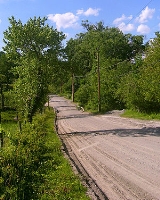
Old Albany Post Road is a 6.6 miles (10.6 km) dirt road
in Philipstown
, New York, one of the oldest unpaved roads still in use in the United States
. It runs mostly north-south through the southeastern corner of the town, near the Putnam Valley
town line. Starting from an intersection with Sprout Brook Road at Continental Village just north of the Putnam
-Westchester
county line, it ends at an oblique junction with US 9 east of Garrison
.
As the least improved section of the original Albany Post Road
, it was added to the National Register of Historic Places
(NRHP) in 1982. Its history as a formal road dates to the mid-17th century, when it was built on established Native American
trails. Later it would see military use, particularly by the Continental Army
during the Revolution
, and commercial use as part of a stagecoach
route. Some of the milestone
s placed during the early years of American independence to more accurately calculate postal rates are still present and have been preserved and restored. It is still in public use and maintained by the town. The town has recently angered some of the residents by proposing to pave the road.
. Houses, many on large lots
, are the only development along the road, and there are no settlements along its length. The countryside is rugged, with the road going up and down several hills. Some areas are scenic, with meadow
s and views of the nearby hills and mountains.
It branches off to the northwest at the point where Gallows Hill Road becomes Sprout Brook Road. From there it takes a west-northwestward, meandering course at first, narrowing almost to one lane at some points and climbing steadily to where the Catskill Aqueduct
crosses, but soon bends to the north-northeast and widens. It climbs and then descends over the next two miles (3 km) to the Lake Celeste area, where it becomes more northerly. Then it bends to the northeast again, going up and down several hills through mostly undeveloped areas, to Chapman Road, where the Appalachian Trail
crosses.
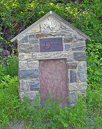
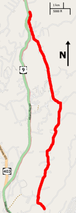 Out of that intersection it resumes its northward course, traversing around Fort Defiance Mountain, to Canopus Hill Road. There it turns to the northwest. At the corner of Travis Corners Road, a monument
explains the historical importance of the road. From here it runs almost straight north-northwest past some farms and more open land to cross Philipse Brook at the junction with Philipse Brook Road.
Beyond, the road remains mostly straight and northwestward, eventually returning to more wooded country along a ridgetop where the southwestern corner of Clarence Fahnestock State Park
is nearby. It then turns more to the west and descends to the intersection with Indian Brook Road
, near the Bird and Bottle Inn. From here it parallels nearby Route 9, reaching some more developed areas until it finally ends with a merge onto the highway.
. Old Albany Post Road has not seen much change since the mid-18th century. Later improvements in transportation technology diverted traffic away from it and have helped to preserve the road in its historic form.
designated a postal route between what would later be New York City
and Albany
, the colony's two most important cities at the time. It was little more than a narrow path in many places, following old trails used by the Wiccoppe and Wappinger tribes, who often carried the mail, starting two years later. The longest stretch included part of the current Old Albany Post Road. The colony eventually became the English Province of New York
, and in 1703 its legislative body provided for the postal road to be a "public and common general highway" along the same route, starting in Kingsbridge
and ending at a ferry landing in present-day Rensselaer
. That legislation authorized the road to be as much as four rods (50 feet (15.2 m)) wide where necessary. It was called the Queen's Road at first, after then-Queen Anne
, and later the King's Road when she was succeeded by George I
and II
.
As it became the main route between the two cities, local commerce began to serve the long-distance travelers. Inns are recorded along the road as early as the 1730s, when it was first widened for military use. The best-known, John Warren's Tavern, was built in 1756 and remains in use today as the Bird and Bottle Inn restaurant at the junction with Indian Brook Road.
The road received major improvements when the British Army realized it needed to improve defenses against the French
to the north in New France
(today's Quebec
). In 1754, it was widened again and trees were cleared to allow the transport of troops and materiel in greater numbers. Milestones were first known to have been placed in 1763, sometime after Benjamin Franklin
, who had advocated their use, was appointed the colonies' Joint Postmaster General
.
After the French and Indian War
, it would be used against the British by George Washington
's Continental Army
during the Revolutionary War
. He retreated to what was named Continental Village after the Battle of White Plains
and the road remained fortified and defended throughout the war, used as a supply route, and often traveled by Washington and his officers. It was surveyed
during the war and the first map published. Its milestone locations are not the extant ones.
route was chartered along the road by the legislature in 1785, and the mileposts were upgraded by the end of the century. By then a regular mail route was in place, with riders going up the east side of the river and down another road on the west side on a weekly basis.
In 1789 a new survey was taken and the old maps revised. These match today's known milestone locations along the entire former length of the road. A decade later, New York's Act to Regulate the Highways directed every county highway superintendent to place stone mile markers along the road. By the next year all the remaining mileposts had been placed.
A private company built the Highlands Turnpike to the west, in more level country, and opened it in 1806. This diverted traffic away from the section north of Peekskill
through Continental Village and past the lakes. Iron mining at Hopper Lake in the 1820s partially replaced it, and the stage route was not changed. The old road fell into further disuse when the turnpike became a public highway in 1833 and it was no longer needed as a shunpike
. The completion of the Hudson River Railroad to Albany in 1850 made the road obsolete as a commercial and postal artery, and stage service ended.
in the Catskills
. The road provided access to a section of the Catskill Aqueduct
, and shops, housing and bars were built along it to shelter and serve the construction workers. A decade later, Highlands Turnpike, by then the main north-south route through the county, was paved and formally designated as Route 9.
In 1921 a monument
to the "Mothers of the Revolution" was placed at the southern end. Homes and farms along the road were electrified
in 1935 due to the efforts of the newly-created Rural Electrification Administration, adding utility pole
s to the landscape. A portion of the road near Travis Corners was surfaced in tar
and gravel
in the 20th century. Beyond that, it remains as it was in the mid-18th century. Following its NRHP listing, a group called the Old Road Society of Philipstown (ORSP) was formed to help preserve and promote it. Its membership is open to residents along the road and intersecting dirt roads.
The town has, in recent years, raised the possibility of paving it, saying it would be cheaper to maintain and silt
s up a paralleling brook through erosion
. This has divided residents along Old Albany Post Road. Opponents point to its historic designation, character and rural charm, which would be lost if it were surfaced. Proponents, many near the road's southern end, cite public safety
concerns such as inaccessibility for police and fire vehicles during washout
s in heavy storms like the April 2007 Nor'easter
, which left craters four feet (1.3 m) deep in front of some driveway
s. The Federal Emergency Management Agency
has given the town a grant
to repair it, although it has not been decided whether it will be used for pavement or not.
s and shade tree
s, are considered contributing resources
to the designation. The milestones are all included, even number 52, which is actually located on Gallows Hill Road slightly to the south of the fork at Sprout Hill.
Some of the buildings along the road have been noted for their historic value by the ORSP. The Bird and Bottle Inn is a contributing property to the Indian Brook Road Historic District
, which itself includes part of the road as one of its contributing properties. In the two-mile (3.2 km) section to its south there is also a Civil War
-era farmhouse
and 1770s in, both of which have seen more recent additions. Opposite Lake Celeste is Pine Run Farm, which dates to 1800.
Dirt road
Dirt road is a common term for an unpaved road made from the native material of the land surface through which it passes, known to highway engineers as subgrade material. Dirt roads are suitable for vehicles; a narrower path for pedestrians, animals, and possibly small vehicles would be called a...
in Philipstown
Philipstown, New York
Philipstown is a town located in the western part of Putnam County, New York, United States. The population was 9,422 at the 2000 census.- History :The town was first settled around 1715....
, New York, one of the oldest unpaved roads still in use in the United States
United States
The United States of America is a federal constitutional republic comprising fifty states and a federal district...
. It runs mostly north-south through the southeastern corner of the town, near the Putnam Valley
Putnam Valley, New York
Putnam Valley is a town in Putnam County, New York, United States. The population was 10,686 at the 2000 census. Its location is northeast of New York City.The Town of Putnam Valley is in the southwest part of Putnam County...
town line. Starting from an intersection with Sprout Brook Road at Continental Village just north of the Putnam
Putnam County, New York
Putnam County is a county located in the U.S. state of New York, in the lower Hudson River Valley. Putnam county formed in 1812, when it detached from Dutchess County. , the population was 99,710. It is part of the New York Metropolitan Area. The county seat is the hamlet of Carmel...
-Westchester
Westchester County, New York
Westchester County is a county located in the U.S. state of New York. Westchester covers an area of and has a population of 949,113 according to the 2010 Census, residing in 45 municipalities...
county line, it ends at an oblique junction with US 9 east of Garrison
Garrison, New York
Garrison is a hamlet in Putnam County, New York, United States. It is part of the town of Philipstown and is on the east side of the Hudson River, across from the United States Military Academy at West Point...
.
As the least improved section of the original Albany Post Road
Albany Post Road
The Albany Post Road was a post road - a road used for mail delivery - in the U.S. state of New York. It connected the cities of New York and Albany along the east side of the Hudson River, a service now performed by US 9.The rough route was as follows:...
, it was added to the National Register of Historic Places
National Register of Historic Places
The National Register of Historic Places is the United States government's official list of districts, sites, buildings, structures, and objects deemed worthy of preservation...
(NRHP) in 1982. Its history as a formal road dates to the mid-17th century, when it was built on established Native American
Native Americans in the United States
Native Americans in the United States are the indigenous peoples in North America within the boundaries of the present-day continental United States, parts of Alaska, and the island state of Hawaii. They are composed of numerous, distinct tribes, states, and ethnic groups, many of which survive as...
trails. Later it would see military use, particularly by the Continental Army
Continental Army
The Continental Army was formed after the outbreak of the American Revolutionary War by the colonies that became the United States of America. Established by a resolution of the Continental Congress on June 14, 1775, it was created to coordinate the military efforts of the Thirteen Colonies in...
during the Revolution
American Revolutionary War
The American Revolutionary War , the American War of Independence, or simply the Revolutionary War, began as a war between the Kingdom of Great Britain and thirteen British colonies in North America, and ended in a global war between several European great powers.The war was the result of the...
, and commercial use as part of a stagecoach
Stagecoach
A stagecoach is a type of covered wagon for passengers and goods, strongly sprung and drawn by four horses, usually four-in-hand. Widely used before the introduction of railway transport, it made regular trips between stages or stations, which were places of rest provided for stagecoach travelers...
route. Some of the milestone
Milestone
A milestone is one of a series of numbered markers placed along a road or boundary at intervals of one mile or occasionally, parts of a mile. They are typically located at the side of the road or in a median. They are alternatively known as mile markers, mileposts or mile posts...
s placed during the early years of American independence to more accurately calculate postal rates are still present and have been preserved and restored. It is still in public use and maintained by the town. The town has recently angered some of the residents by proposing to pave the road.
Route
Old Albany Post Road passes through heavily wooded and lightly populated country along the southeastern edge of the Hudson HighlandsHudson Highlands
The Hudson Highlands are mountains on both sides of the Hudson River in the U.S. state of New York, between Newburgh Bay and Haverstraw Bay, which form the northern region of the New York - New Jersey Highlands....
. Houses, many on large lots
Lot (real estate)
In real estate, a lot or plot is a tract or parcel of land owned or meant to be owned by some owner. A lot is essentially considered a parcel of real property in some countries or immovable property in other countries...
, are the only development along the road, and there are no settlements along its length. The countryside is rugged, with the road going up and down several hills. Some areas are scenic, with meadow
Meadow
A meadow is a field vegetated primarily by grass and other non-woody plants . The term is from Old English mædwe. In agriculture a meadow is grassland which is not grazed by domestic livestock but rather allowed to grow unchecked in order to make hay...
s and views of the nearby hills and mountains.
It branches off to the northwest at the point where Gallows Hill Road becomes Sprout Brook Road. From there it takes a west-northwestward, meandering course at first, narrowing almost to one lane at some points and climbing steadily to where the Catskill Aqueduct
Catskill Aqueduct
The Catskill Aqueduct, part of the New York City water supply system, brings water from the Catskill Mountains to Yonkers where it connects to other parts of the system.-History:Construction commenced in 1907...
crosses, but soon bends to the north-northeast and widens. It climbs and then descends over the next two miles (3 km) to the Lake Celeste area, where it becomes more northerly. Then it bends to the northeast again, going up and down several hills through mostly undeveloped areas, to Chapman Road, where the Appalachian Trail
Appalachian Trail
The Appalachian National Scenic Trail, generally known as the Appalachian Trail or simply the AT, is a marked hiking trail in the eastern United States extending between Springer Mountain in Georgia and Mount Katahdin in Maine. It is approximately long...
crosses.
Monument
A monument is a type of structure either explicitly created to commemorate a person or important event or which has become important to a social group as a part of their remembrance of historic times or cultural heritage, or simply as an example of historic architecture...
explains the historical importance of the road. From here it runs almost straight north-northwest past some farms and more open land to cross Philipse Brook at the junction with Philipse Brook Road.
Beyond, the road remains mostly straight and northwestward, eventually returning to more wooded country along a ridgetop where the southwestern corner of Clarence Fahnestock State Park
Clarence Fahnestock State Park
Clarence Fahnestock Memorial State Park a 14,086 acre New York state park, in Putnam and Dutchess counties. The park has hiking trails, an environmental center, a beach on Canopus Lake, and fishing on four ponds and two lakes...
is nearby. It then turns more to the west and descends to the intersection with Indian Brook Road
Indian Brook Road Historic District
The Indian Brook Road Historic District is located on both sides of that street's intersection with US 9 east of Garrison, New York, United States. Its contain 15 buildings, all but two of which are considered contributing properties to its historic character....
, near the Bird and Bottle Inn. From here it parallels nearby Route 9, reaching some more developed areas until it finally ends with a merge onto the highway.
History
All of the major work of building and widening the road was done during the colonial eraColonial America
The colonial history of the United States covers the history from the start of European settlement and especially the history of the thirteen colonies of Britain until they declared independence in 1776. In the late 16th century, England, France, Spain and the Netherlands launched major...
. Old Albany Post Road has not seen much change since the mid-18th century. Later improvements in transportation technology diverted traffic away from it and have helped to preserve the road in its historic form.
Colonial era
In 1669 the government of New NetherlandNew Netherland
New Netherland, or Nieuw-Nederland in Dutch, was the 17th-century colonial province of the Republic of the Seven United Netherlands on the East Coast of North America. The claimed territories were the lands from the Delmarva Peninsula to extreme southwestern Cape Cod...
designated a postal route between what would later be New York City
New York City
New York is the most populous city in the United States and the center of the New York Metropolitan Area, one of the most populous metropolitan areas in the world. New York exerts a significant impact upon global commerce, finance, media, art, fashion, research, technology, education, and...
and Albany
Albany, New York
Albany is the capital city of the U.S. state of New York, the seat of Albany County, and the central city of New York's Capital District. Roughly north of New York City, Albany sits on the west bank of the Hudson River, about south of its confluence with the Mohawk River...
, the colony's two most important cities at the time. It was little more than a narrow path in many places, following old trails used by the Wiccoppe and Wappinger tribes, who often carried the mail, starting two years later. The longest stretch included part of the current Old Albany Post Road. The colony eventually became the English Province of New York
Province of New York
The Province of New York was an English and later British crown territory that originally included all of the present U.S. states of New York, New Jersey, Delaware and Vermont, along with inland portions of Connecticut, Massachusetts, and Maine, as well as eastern Pennsylvania...
, and in 1703 its legislative body provided for the postal road to be a "public and common general highway" along the same route, starting in Kingsbridge
Kingsbridge, Bronx
Kingsbridge is a working class residential neighborhood geographically located in the northwest Bronx in New York City. The neighborhood is part of Bronx Community Board 8. Its boundaries are Van Cortlandt Park to the north, Goulden Avenue to the east, West 225th Street to the south, and Irwin...
and ending at a ferry landing in present-day Rensselaer
Rensselaer, New York
Rensselaer is a city in Rensselaer County, New York, United States, and is located on the Hudson River directly opposite Albany. As of the 2010 census, the city population was 9,392; in 1920, it was 10,832. The name is from Kiliaen van Rensselaer, the original landowner of the region in New...
. That legislation authorized the road to be as much as four rods (50 feet (15.2 m)) wide where necessary. It was called the Queen's Road at first, after then-Queen Anne
Anne of Great Britain
Anne ascended the thrones of England, Scotland and Ireland on 8 March 1702. On 1 May 1707, under the Act of Union, two of her realms, England and Scotland, were united as a single sovereign state, the Kingdom of Great Britain.Anne's Catholic father, James II and VII, was deposed during the...
, and later the King's Road when she was succeeded by George I
George I of Great Britain
George I was King of Great Britain and Ireland from 1 August 1714 until his death, and ruler of the Duchy and Electorate of Brunswick-Lüneburg in the Holy Roman Empire from 1698....
and II
George II of Great Britain
George II was King of Great Britain and Ireland, Duke of Brunswick-Lüneburg and Archtreasurer and Prince-elector of the Holy Roman Empire from 11 June 1727 until his death.George was the last British monarch born outside Great Britain. He was born and brought up in Northern Germany...
.
As it became the main route between the two cities, local commerce began to serve the long-distance travelers. Inns are recorded along the road as early as the 1730s, when it was first widened for military use. The best-known, John Warren's Tavern, was built in 1756 and remains in use today as the Bird and Bottle Inn restaurant at the junction with Indian Brook Road.
The road received major improvements when the British Army realized it needed to improve defenses against the French
French colonization of the Americas
The French colonization of the Americas began in the 16th century, and continued in the following centuries as France established a colonial empire in the Western Hemisphere. France founded colonies in much of eastern North America, on a number of Caribbean islands, and in South America...
to the north in New France
New France
New France was the area colonized by France in North America during a period beginning with the exploration of the Saint Lawrence River by Jacques Cartier in 1534 and ending with the cession of New France to Spain and Great Britain in 1763...
(today's Quebec
Quebec
Quebec or is a province in east-central Canada. It is the only Canadian province with a predominantly French-speaking population and the only one whose sole official language is French at the provincial level....
). In 1754, it was widened again and trees were cleared to allow the transport of troops and materiel in greater numbers. Milestones were first known to have been placed in 1763, sometime after Benjamin Franklin
Benjamin Franklin
Dr. Benjamin Franklin was one of the Founding Fathers of the United States. A noted polymath, Franklin was a leading author, printer, political theorist, politician, postmaster, scientist, musician, inventor, satirist, civic activist, statesman, and diplomat...
, who had advocated their use, was appointed the colonies' Joint Postmaster General
United States Postmaster General
The United States Postmaster General is the Chief Executive Officer of the United States Postal Service. The office, in one form or another, is older than both the United States Constitution and the United States Declaration of Independence...
.
After the French and Indian War
French and Indian War
The French and Indian War is the common American name for the war between Great Britain and France in North America from 1754 to 1763. In 1756, the war erupted into the world-wide conflict known as the Seven Years' War and thus came to be regarded as the North American theater of that war...
, it would be used against the British by George Washington
George Washington
George Washington was the dominant military and political leader of the new United States of America from 1775 to 1799. He led the American victory over Great Britain in the American Revolutionary War as commander-in-chief of the Continental Army from 1775 to 1783, and presided over the writing of...
's Continental Army
Continental Army
The Continental Army was formed after the outbreak of the American Revolutionary War by the colonies that became the United States of America. Established by a resolution of the Continental Congress on June 14, 1775, it was created to coordinate the military efforts of the Thirteen Colonies in...
during the Revolutionary War
American Revolutionary War
The American Revolutionary War , the American War of Independence, or simply the Revolutionary War, began as a war between the Kingdom of Great Britain and thirteen British colonies in North America, and ended in a global war between several European great powers.The war was the result of the...
. He retreated to what was named Continental Village after the Battle of White Plains
Battle of White Plains
The Battle of White Plains was a battle in the New York and New Jersey campaign of the American Revolutionary War fought on October 28, 1776, near White Plains, New York. Following the retreat of George Washington's Continental Army northward from New York City, British General William Howe landed...
and the road remained fortified and defended throughout the war, used as a supply route, and often traveled by Washington and his officers. It was surveyed
Surveying
See Also: Public Land Survey SystemSurveying or land surveying is the technique, profession, and science of accurately determining the terrestrial or three-dimensional position of points and the distances and angles between them...
during the war and the first map published. Its milestone locations are not the extant ones.
18th and 19th centuries
After the war, the new state began making further use of the road. A regular stagecoachStagecoach
A stagecoach is a type of covered wagon for passengers and goods, strongly sprung and drawn by four horses, usually four-in-hand. Widely used before the introduction of railway transport, it made regular trips between stages or stations, which were places of rest provided for stagecoach travelers...
route was chartered along the road by the legislature in 1785, and the mileposts were upgraded by the end of the century. By then a regular mail route was in place, with riders going up the east side of the river and down another road on the west side on a weekly basis.
In 1789 a new survey was taken and the old maps revised. These match today's known milestone locations along the entire former length of the road. A decade later, New York's Act to Regulate the Highways directed every county highway superintendent to place stone mile markers along the road. By the next year all the remaining mileposts had been placed.
A private company built the Highlands Turnpike to the west, in more level country, and opened it in 1806. This diverted traffic away from the section north of Peekskill
Peekskill, New York
Peekskill is a city in Westchester County, New York. It is situated on a bay along the east side of the Hudson River, across from Jones Point.This community was known to be an early American industrial center, primarily for its iron plow and stove products...
through Continental Village and past the lakes. Iron mining at Hopper Lake in the 1820s partially replaced it, and the stage route was not changed. The old road fell into further disuse when the turnpike became a public highway in 1833 and it was no longer needed as a shunpike
Shunpike
Shunpike is a non-profit arts organization that functions primarily as a fiscal sponsor. The organization is based in Seattle and works mostly with artists from the Puget Sound Region. In July 2009, Shunpike opened a satellite branch in Tacoma.-History:...
. The completion of the Hudson River Railroad to Albany in 1850 made the road obsolete as a commercial and postal artery, and stage service ended.
20th and 21st centuries
Old Albany Post Road briefly assumed more than local importance once more in the 1910s, when the New York City water supply system was expanded to bring water to the city from Ashokan ReservoirAshokan Reservoir
The Ashokan Reservoir is a reservoir in Ulster County, New York, USA. The reservoir is in the eastern end of the Catskill Park, and is one of several reservoirs created to provide the City of New York with water. However, it is one of only two reservoirs in the Catskill Watershed. It is also New...
in the Catskills
Catskill Mountains
The Catskill Mountains, an area in New York State northwest of New York City and southwest of Albany, are a mature dissected plateau, an uplifted region that was subsequently eroded into sharp relief. They are an eastward continuation, and the highest representation, of the Allegheny Plateau...
. The road provided access to a section of the Catskill Aqueduct
Catskill Aqueduct
The Catskill Aqueduct, part of the New York City water supply system, brings water from the Catskill Mountains to Yonkers where it connects to other parts of the system.-History:Construction commenced in 1907...
, and shops, housing and bars were built along it to shelter and serve the construction workers. A decade later, Highlands Turnpike, by then the main north-south route through the county, was paved and formally designated as Route 9.
In 1921 a monument
Monument
A monument is a type of structure either explicitly created to commemorate a person or important event or which has become important to a social group as a part of their remembrance of historic times or cultural heritage, or simply as an example of historic architecture...
to the "Mothers of the Revolution" was placed at the southern end. Homes and farms along the road were electrified
Rural electrification
Rural electrification is the process of bringing electrical power to rural and remote areas. Electricity is used not only for lighting and household purposes, but it also allows for mechanization of many farming operations, such as threshing, milking, and hoisting grain for storage; in areas...
in 1935 due to the efforts of the newly-created Rural Electrification Administration, adding utility pole
Utility pole
A utility pole is a pole used to support overhead power lines and various other public utilities, such as cable, fibre optic cable, and related equipment such as transformers and street lights. It can be referred to as a telephone pole, power pole, hydro pole, telegraph pole, or telegraph post,...
s to the landscape. A portion of the road near Travis Corners was surfaced in tar
Tar
Tar is modified pitch produced primarily from the wood and roots of pine by destructive distillation under pyrolysis. Production and trade in tar was a major contributor in the economies of Northern Europe and Colonial America. Its main use was in preserving wooden vessels against rot. The largest...
and gravel
Gravel
Gravel is composed of unconsolidated rock fragments that have a general particle size range and include size classes from granule- to boulder-sized fragments. Gravel can be sub-categorized into granule and cobble...
in the 20th century. Beyond that, it remains as it was in the mid-18th century. Following its NRHP listing, a group called the Old Road Society of Philipstown (ORSP) was formed to help preserve and promote it. Its membership is open to residents along the road and intersecting dirt roads.
The town has, in recent years, raised the possibility of paving it, saying it would be cheaper to maintain and silt
Silt
Silt is granular material of a size somewhere between sand and clay whose mineral origin is quartz and feldspar. Silt may occur as a soil or as suspended sediment in a surface water body...
s up a paralleling brook through erosion
Erosion
Erosion is when materials are removed from the surface and changed into something else. It only works by hydraulic actions and transport of solids in the natural environment, and leads to the deposition of these materials elsewhere...
. This has divided residents along Old Albany Post Road. Opponents point to its historic designation, character and rural charm, which would be lost if it were surfaced. Proponents, many near the road's southern end, cite public safety
Public Safety
Public safety involves the prevention of and protection from events that could endanger the safety of the general public from significant danger, injury/harm, or damage, such as crimes or disasters .-See also:* By nation...
concerns such as inaccessibility for police and fire vehicles during washout
Washout
A washout is the sudden erosion of soft soil or other support surfaces by a gush of water, usually occurring during a heavy downpour of rain or other stream flooding. These downpours may occur locally in a thunderstorm , or over a large area, such as following the landfall of a tropical cyclone...
s in heavy storms like the April 2007 Nor'easter
April 2007 Nor'easter
The April or Spring Nor’easter of 2007 was a nor'easter that affected mainly the eastern parts of North America during its four day course April 14 to April 17, 2007. The combined effects of high winds, heavy rainfall, and high tides led to flooding, storm damages, power outages, and evacuations,...
, which left craters four feet (1.3 m) deep in front of some driveway
Driveway
A driveway is a type of private road for local access to one or a small group of structures, and is owned and maintained by an individual or group....
s. The Federal Emergency Management Agency
Federal Emergency Management Agency
The Federal Emergency Management Agency is an agency of the United States Department of Homeland Security, initially created by Presidential Reorganization Plan No. 1 of 1978 and implemented by two Executive Orders...
has given the town a grant
Grant (money)
Grants are funds disbursed by one party , often a Government Department, Corporation, Foundation or Trust, to a recipient, often a nonprofit entity, educational institution, business or an individual. In order to receive a grant, some form of "Grant Writing" often referred to as either a proposal...
to repair it, although it has not been decided whether it will be used for pavement or not.
Contributing historic resources
The entire 50 feet (15.2 m) right-of-way authorized in 1703 is included in the NRHP listing. This means that many other aspects of the structure, like the adjacent stone wallStone wall
Stone walls are a kind of masonry construction which have been made for thousands of years. First they were constructed by farmers and primitive people by piling loose field stones in what is called a dry stone wall, then later with the use of mortar and plaster especially in the construction of...
s and shade tree
Shade tree
A shade tree is any tree grown specifically for its shade. This term usually applies to large trees with spreading canopies. Shade trees are effective in reducing the energy used in cooling homes....
s, are considered contributing resources
Contributing property
In the law regulating historic districts in the United States, a contributing resource or contributing property is any building, structure, or object which adds to the historical integrity or architectural qualities that make the historic district, listed locally or federally, significant...
to the designation. The milestones are all included, even number 52, which is actually located on Gallows Hill Road slightly to the south of the fork at Sprout Hill.
Some of the buildings along the road have been noted for their historic value by the ORSP. The Bird and Bottle Inn is a contributing property to the Indian Brook Road Historic District
Indian Brook Road Historic District
The Indian Brook Road Historic District is located on both sides of that street's intersection with US 9 east of Garrison, New York, United States. Its contain 15 buildings, all but two of which are considered contributing properties to its historic character....
, which itself includes part of the road as one of its contributing properties. In the two-mile (3.2 km) section to its south there is also a Civil War
American Civil War
The American Civil War was a civil war fought in the United States of America. In response to the election of Abraham Lincoln as President of the United States, 11 southern slave states declared their secession from the United States and formed the Confederate States of America ; the other 25...
-era farmhouse
Farmhouse
Farmhouse is a general term for the main house of a farm. It is a type of building or house which serves a residential purpose in a rural or agricultural setting. Most often, the surrounding environment will be a farm. Many farm houses are shaped like a T...
and 1770s in, both of which have seen more recent additions. Opposite Lake Celeste is Pine Run Farm, which dates to 1800.