
Indian Brook Road Historic District
Encyclopedia
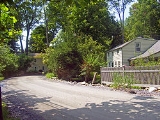
The Indian Brook Road Historic District is located on both sides of that street's intersection with US 9 east of Garrison
, New York, United States. Its 30 acres (12.1 ha) contain 15 buildings, all but two of which are considered contributing properties
to its historic character.
From the late 18th to mid-20th century, the area was a rural hamlet known first as Warrens and later as Nelson's Corner. Unlike most other such small country settlements, it has survived industrialization and the automobile era with its basic plan, and most of its buildings, relatively intact. In 1993 the area was designated a historic district
and added to the National Register of Historic Places
.
Indian Brook Road joined by a narrow corridor along the brief, paved section of Route 9 that connects them. These boundaries reflect the extent of Nelson's Corner during its peak period of growth in the late 19th century. They include all of ten separate lots
.
The land in the district is heavily wooded, with tall trees shading the buildings within, mostly frame
houses and supporting structures no higher than two stories. Indian Brook, the tributary
of the Hudson River
that lends its name to the district, closely parallels the road and is even partially included as a contributing property, due to an early mill pond
's location along it. The entire area is amid the lesser hills of the Hudson Highlands
.
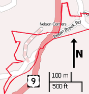 On the east side of US 9, the district takes in a small portion of Old Albany Post Road
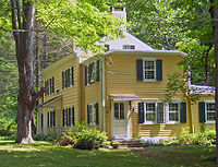
, the only contributing property separately listed on the Register as an important early local transportation route and still one of the oldest dirt roads still in use in the United States. At this junction is the Bird and Bottle Inn, a surviving tavern from the early days of Nelson's Corner that incorporates a small portion of the original building. The west goes as far as a former intersection known as "The Bend" and includes a large lot that climbs the slopes of Cat Hill to the northwest.
, Samuel Warren's home in the area became well-known enough as a rest stop along the Albany Post Road
for "Warrens" to appear on maps. In the early 19th century, his son John leased, and built a farm on, 411 acres (166.3 ha) that include the entire current historic district. His house, on the future site of the Bird and Bottle, was also open as a tavern for travelers. John's brother Samuel Jr. also built a house for his family on the property, just west of the highway. Both are prominent features of the district, built in the vernacular
style
common among Americans of English descent
at that time.
 In 1804 the Highlands Turnpike, a more level alternative route to the Post Road currently followed by US 9, was opened. At the hamlet, it deviated slightly from the current alignment, following Indian Brook down to a four-way junction known as the Bend, where a now-abandoned roadway went south over the brook to rejoin the road still in use.
Warren was not able to buy his land outright until 1821, when a compensation claim by the heirs of Frederick Philipse, the local landowner whose holdings had been confiscated by the state for his Loyalist
sympathies during the war, was settled on the condition that all leaseholds be abolished.
Sometime in the early 19th century (the exact date is not known), John Warren dam
med Indian Brook to create a mill and pond as a way of increasing the economic worth of his property. This began to make the farm into a settlement rather than just a rest stop on a long highway, as the other three houses in the district were built during this period. They show the influence of the Federal style popular in the new nation at the time. Samuel Warren's house was also enlarged during this period, and the sections of the brook nearby were channelized to control flooding
The Warren brothers both died in the mid-1830s. After a series of transactions that briefly took John's property out of the family, by 1854 it was back in the family, owned by his son-in-law John Nelson. Samuel's home remained in his descendants' hands for another four decades.
John Nelson closed the tavern, since the rise of the railroads had diverted much of the traffic once handled by the Post Road to the riverside, and used the building as his family residence. Maps now named the area Nelson's Corner. He continued to operate the mill. A school was built in 1844, but other than that there were few changes to the hamlet in the late 19th century, as the focus of the economy had moved elsewhere with the rise of industry.
and Albany
. The state cut a new section of Route 9 that bypassed the Bend, making passage through the hamlet easier for travelers and also helping to preserve the hamlet buildings on that side of the new highway.
Roadside businesses flourished on the new road for a time. In 1939 John Warren's old tavern was expanded in the Colonial Revival
style that had already been applied to other buildings in the hamlet, and reopened as the Bird and Bottle. After the war, the state built limited-access road
s like the Taconic State Parkway
and the New York State Thruway
that made the trip up the Hudson Valley
faster and took much of the traffic off Route 9 again.
Many of those who had visited the area were city residents, and some were drawn to move to the area at least part-time, a trend that had begun with the large estates built in the area during the late 19th century. In the late 20th, with easier auto and rail access, this led to the suburbanization
of eastern Putnam County
. Some of this development has occurred near the district, but not in it. It remains very similar to the place it was in the early 19th century.
Garrison, New York
Garrison is a hamlet in Putnam County, New York, United States. It is part of the town of Philipstown and is on the east side of the Hudson River, across from the United States Military Academy at West Point...
, New York, United States. Its 30 acres (12.1 ha) contain 15 buildings, all but two of which are considered contributing properties
Contributing property
In the law regulating historic districts in the United States, a contributing resource or contributing property is any building, structure, or object which adds to the historical integrity or architectural qualities that make the historic district, listed locally or federally, significant...
to its historic character.
From the late 18th to mid-20th century, the area was a rural hamlet known first as Warrens and later as Nelson's Corner. Unlike most other such small country settlements, it has survived industrialization and the automobile era with its basic plan, and most of its buildings, relatively intact. In 1993 the area was designated a historic district
Historic district (United States)
In the United States, a historic district is a group of buildings, properties, or sites that have been designated by one of several entities on different levels as historically or architecturally significant. Buildings, structures, objects and sites within a historic district are normally divided...
and added to the National Register of Historic Places
National Register of Historic Places
The National Register of Historic Places is the United States government's official list of districts, sites, buildings, structures, and objects deemed worthy of preservation...
.
Geography
The district consists of two irregularly shaped areas along unpavedDirt road
Dirt road is a common term for an unpaved road made from the native material of the land surface through which it passes, known to highway engineers as subgrade material. Dirt roads are suitable for vehicles; a narrower path for pedestrians, animals, and possibly small vehicles would be called a...
Indian Brook Road joined by a narrow corridor along the brief, paved section of Route 9 that connects them. These boundaries reflect the extent of Nelson's Corner during its peak period of growth in the late 19th century. They include all of ten separate lots
Lot (real estate)
In real estate, a lot or plot is a tract or parcel of land owned or meant to be owned by some owner. A lot is essentially considered a parcel of real property in some countries or immovable property in other countries...
.
The land in the district is heavily wooded, with tall trees shading the buildings within, mostly frame
Framing (construction)
Framing, in construction known as light-frame construction, is a building technique based around structural members, usually called studs, which provide a stable frame to which interior and exterior wall coverings are attached, and covered by a roof comprising horizontal ceiling joists and sloping...
houses and supporting structures no higher than two stories. Indian Brook, the tributary
Tributary
A tributary or affluent is a stream or river that flows into a main stem river or a lake. A tributary does not flow directly into a sea or ocean...
of the Hudson River
Hudson River
The Hudson is a river that flows from north to south through eastern New York. The highest official source is at Lake Tear of the Clouds, on the slopes of Mount Marcy in the Adirondack Mountains. The river itself officially begins in Henderson Lake in Newcomb, New York...
that lends its name to the district, closely parallels the road and is even partially included as a contributing property, due to an early mill pond
Mill pond
A mill pond is any body of water used as a reservoir for a water-powered mill. Mill ponds were often created through the construction of a mill dam across a waterway. In many places, the common proper name Mill Pond name has remained even though the mill has long since gone...
's location along it. The entire area is amid the lesser hills of the Hudson Highlands
Hudson Highlands
The Hudson Highlands are mountains on both sides of the Hudson River in the U.S. state of New York, between Newburgh Bay and Haverstraw Bay, which form the northern region of the New York - New Jersey Highlands....
.
Old Albany Post Road
Old Albany Post Road is a dirt road in Philipstown, New York, one of the oldest unpaved roads still in use in the United States. It runs mostly north-south through the southeastern corner of the town, near the Putnam Valley town line...
, the only contributing property separately listed on the Register as an important early local transportation route and still one of the oldest dirt roads still in use in the United States. At this junction is the Bird and Bottle Inn, a surviving tavern from the early days of Nelson's Corner that incorporates a small portion of the original building. The west goes as far as a former intersection known as "The Bend" and includes a large lot that climbs the slopes of Cat Hill to the northwest.
19th century
Around the time of the RevolutionAmerican Revolution
The American Revolution was the political upheaval during the last half of the 18th century in which thirteen colonies in North America joined together to break free from the British Empire, combining to become the United States of America...
, Samuel Warren's home in the area became well-known enough as a rest stop along the Albany Post Road
Albany Post Road
The Albany Post Road was a post road - a road used for mail delivery - in the U.S. state of New York. It connected the cities of New York and Albany along the east side of the Hudson River, a service now performed by US 9.The rough route was as follows:...
for "Warrens" to appear on maps. In the early 19th century, his son John leased, and built a farm on, 411 acres (166.3 ha) that include the entire current historic district. His house, on the future site of the Bird and Bottle, was also open as a tavern for travelers. John's brother Samuel Jr. also built a house for his family on the property, just west of the highway. Both are prominent features of the district, built in the vernacular
Vernacular architecture
Vernacular architecture is a term used to categorize methods of construction which use locally available resources and traditions to address local needs and circumstances. Vernacular architecture tends to evolve over time to reflect the environmental, cultural and historical context in which it...
style
Architectural style
Architectural styles classify architecture in terms of the use of form, techniques, materials, time period, region and other stylistic influences. It overlaps with, and emerges from the study of the evolution and history of architecture...
common among Americans of English descent
British colonization of the Americas
British colonization of the Americas began in 1607 in Jamestown, Virginia and reached its peak when colonies had been established throughout the Americas...
at that time.
Warren was not able to buy his land outright until 1821, when a compensation claim by the heirs of Frederick Philipse, the local landowner whose holdings had been confiscated by the state for his Loyalist
Loyalist (American Revolution)
Loyalists were American colonists who remained loyal to the Kingdom of Great Britain during the American Revolutionary War. At the time they were often called Tories, Royalists, or King's Men. They were opposed by the Patriots, those who supported the revolution...
sympathies during the war, was settled on the condition that all leaseholds be abolished.
Sometime in the early 19th century (the exact date is not known), John Warren dam
Dam
A dam is a barrier that impounds water or underground streams. Dams generally serve the primary purpose of retaining water, while other structures such as floodgates or levees are used to manage or prevent water flow into specific land regions. Hydropower and pumped-storage hydroelectricity are...
med Indian Brook to create a mill and pond as a way of increasing the economic worth of his property. This began to make the farm into a settlement rather than just a rest stop on a long highway, as the other three houses in the district were built during this period. They show the influence of the Federal style popular in the new nation at the time. Samuel Warren's house was also enlarged during this period, and the sections of the brook nearby were channelized to control flooding
Flood control
In communications, flood control is a feature of many communication protocols designed to prevent overwhelming of a destination receiver. Such controls can be implemented either in software or in hardware, and will often request that the message be resent after the receiver has finished...
The Warren brothers both died in the mid-1830s. After a series of transactions that briefly took John's property out of the family, by 1854 it was back in the family, owned by his son-in-law John Nelson. Samuel's home remained in his descendants' hands for another four decades.
John Nelson closed the tavern, since the rise of the railroads had diverted much of the traffic once handled by the Post Road to the riverside, and used the building as his family residence. Maps now named the area Nelson's Corner. He continued to operate the mill. A school was built in 1844, but other than that there were few changes to the hamlet in the late 19th century, as the focus of the economy had moved elsewhere with the rise of industry.
20th century
In the early 20th century, another transportation shift brought travelers back to the hamlet. Automobiles became more common, and adventurous drivers ventured down long-neglected rural roads in search of interesting places like Nelson's Corner. Route 9 was designated and paved in 1912, and once again Nelson's Corner was a stop on a long road between New York CityNew York City
New York is the most populous city in the United States and the center of the New York Metropolitan Area, one of the most populous metropolitan areas in the world. New York exerts a significant impact upon global commerce, finance, media, art, fashion, research, technology, education, and...
and Albany
Albany, New York
Albany is the capital city of the U.S. state of New York, the seat of Albany County, and the central city of New York's Capital District. Roughly north of New York City, Albany sits on the west bank of the Hudson River, about south of its confluence with the Mohawk River...
. The state cut a new section of Route 9 that bypassed the Bend, making passage through the hamlet easier for travelers and also helping to preserve the hamlet buildings on that side of the new highway.
Roadside businesses flourished on the new road for a time. In 1939 John Warren's old tavern was expanded in the Colonial Revival
Colonial Revival architecture
The Colonial Revival was a nationalistic architectural style, garden design, and interior design movement in the United States which sought to revive elements of Georgian architecture, part of a broader Colonial Revival Movement in the arts. In the early 1890s Americans began to value their own...
style that had already been applied to other buildings in the hamlet, and reopened as the Bird and Bottle. After the war, the state built limited-access road
Limited-access road
A limited-access road known by various terms worldwide, including limited-access highway, dual-carriageway and expressway, is a highway or arterial road for high-speed traffic which has many or most characteristics of a controlled-access highway , including limited or no access to adjacent...
s like the Taconic State Parkway
Taconic State Parkway
The Taconic State Parkway , is a divided highway between Kensico Dam and Chatham, the longest parkway in the U.S. state of New York. It follows a generally northward route midway between the Hudson River and the Connecticut and Massachusetts state lines...
and the New York State Thruway
New York State Thruway
The New York State Thruway is a system of limited-access highways located within the state of New York in the United States. The system, known officially as the Governor Thomas E. Dewey Thruway for former New York Governor Thomas E. Dewey, is operated by the New York State Thruway Authority and...
that made the trip up the Hudson Valley
Hudson Valley
The Hudson Valley comprises the valley of the Hudson River and its adjacent communities in New York State, United States, from northern Westchester County northward to the cities of Albany and Troy.-History:...
faster and took much of the traffic off Route 9 again.
Many of those who had visited the area were city residents, and some were drawn to move to the area at least part-time, a trend that had begun with the large estates built in the area during the late 19th century. In the late 20th, with easier auto and rail access, this led to the suburbanization
Suburbanization
Suburbanization a term used to describe the growth of areas on the fringes of major cities. It is one of the many causes of the increase in urban sprawl. Many residents of metropolitan regions work within the central urban area, choosing instead to live in satellite communities called suburbs...
of eastern Putnam County
Putnam County, New York
Putnam County is a county located in the U.S. state of New York, in the lower Hudson River Valley. Putnam county formed in 1812, when it detached from Dutchess County. , the population was 99,710. It is part of the New York Metropolitan Area. The county seat is the hamlet of Carmel...
. Some of this development has occurred near the district, but not in it. It remains very similar to the place it was in the early 19th century.