
Rangitikei River
Encyclopedia
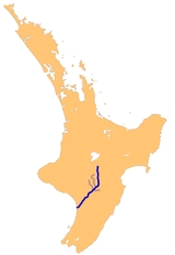
The Rangitikei River is one of New Zealand
's longest rivers, 185 kilometers long.
Its headwaters are to the southeast of Lake Taupo
in the Kaimanawa Ranges. It flows from the Central Plateau south past Taihape
, Mangaweka, Hunterville
, Marton
, and Bulls
, to the South Taranaki Bight
at Tangimoana
, 40 kilometres southeast of Wanganui
. The river gives its name to the surrounding Rangitikei District.
In 1897 the river flooded and all six bridges over it were damaged or destroyed. The port at the mouth of the river was also washed away and never rebuilt.
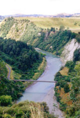
The river is a popular leisure and recreation area for jetboating, white water rafting, kayaking and fishing. Its sheer vertical "paapa" (clay) cliffs (unique to this part of New Zealand) and deep canyons provide the perfect setting for adventure activities such as bungy jumps and flying fox rides. Gravity Canyon on the Mokai reach is a world-famous attraction. Part of the river was used as the Anduin
River in Peter Jackson
's movie The Lord of the Rings: The Fellowship of the Ring.
New Zealand
New Zealand is an island country in the south-western Pacific Ocean comprising two main landmasses and numerous smaller islands. The country is situated some east of Australia across the Tasman Sea, and roughly south of the Pacific island nations of New Caledonia, Fiji, and Tonga...
's longest rivers, 185 kilometers long.
Its headwaters are to the southeast of Lake Taupo
Lake Taupo
Lake Taupo is a lake situated in the North Island of New Zealand. With a surface area of , it is the largest lake by surface area in New Zealand, and the second largest freshwater lake by surface area in geopolitical Oceania after Lake Murray ....
in the Kaimanawa Ranges. It flows from the Central Plateau south past Taihape
Taihape
Taihape is the Northern gateway town of the Rangitikei District, located near the middle of the North Island of New Zealand. It services a large rural community and lies on State Highway 1, which runs through the centre of the North Island.- Economy :...
, Mangaweka, Hunterville
Hunterville, New Zealand
Hunterville is a small community on State Highway 1, in the Rangitikei district of the North Island of New Zealand. It is located half way between Taupo and Wellington and has a population of 507....
, Marton
Marton, New Zealand
Marton is the hub of the Rangitikei district of the Manawatu-Wanganui region of New Zealand's North Island. It is situated 35 kilometres southeast of Wanganui and 40 kilometres northwest of Palmerston North. The population was 4752 .-History:...
, and Bulls
Bulls, New Zealand
Bulls is a small town near Palmerston North on the west coast of the North Island of New Zealand. It is in a thriving farming area in the Rangitikei District at the junction of State Highways 1 and 3 about 160 kilometres north of Wellington...
, to the South Taranaki Bight
South Taranaki Bight
The South Taranaki Bight is the name given to the large bay which extends south and east from the south coast of Taranaki in New Zealand's North Island. With more symmetry than poetry or originality, it is matched by the North Taranaki Bight to the north of Cape Egmont.The size of the bight...
at Tangimoana
Tangimoana
Tangimoana is a community in the Manawatu-Wanganui Region of the North Island of New Zealand. It had a population of 290 permanent residents in 2001. It is located 15 kilometres southwest of Bulls, and 30 kilometres west of Palmerston North....
, 40 kilometres southeast of Wanganui
Wanganui
Whanganui , also spelled Wanganui, is an urban area and district on the west coast of the North Island of New Zealand. It is part of the Manawatu-Wanganui region....
. The river gives its name to the surrounding Rangitikei District.
In 1897 the river flooded and all six bridges over it were damaged or destroyed. The port at the mouth of the river was also washed away and never rebuilt.
The river is a popular leisure and recreation area for jetboating, white water rafting, kayaking and fishing. Its sheer vertical "paapa" (clay) cliffs (unique to this part of New Zealand) and deep canyons provide the perfect setting for adventure activities such as bungy jumps and flying fox rides. Gravity Canyon on the Mokai reach is a world-famous attraction. Part of the river was used as the Anduin
Anduin
In J. R. R. Tolkien's fictional Middle-earth, Anduin is the Sindarin name for the Great River of Wilderland, the longest river in the Third Age . The ancestors of the Rohirrim called it Langflood. It flowed from its source in the Grey and Misty Mountains to the Mouths of Anduin in the Great Sea...
River in Peter Jackson
Peter Jackson
Sir Peter Robert Jackson, KNZM is a New Zealand film director, producer, actor, and screenwriter, known for his The Lord of the Rings film trilogy , adapted from the novel by J. R. R...
's movie The Lord of the Rings: The Fellowship of the Ring.