
Manawatu District
Encyclopedia
| Manawatu District | |
| Country: | New Zealand New Zealand New Zealand is an island country in the south-western Pacific Ocean comprising two main landmasses and numerous smaller islands. The country is situated some east of Australia across the Tasman Sea, and roughly south of the Pacific island nations of New Caledonia, Fiji, and Tonga... |
| Population: | (territorial) |
| Main town: | Feilding Feilding, New Zealand Feilding is a town in the Manawatu-Wanganui Region of the North Island of New Zealand. It is located on State Highway 54, 20 kilometres north of Palmerston North.... |
| Other towns: | Sanson, Bunnythorpe, Hiwinui, Awahuri, Colyton, Pohangina, Rangiwahia, Ruahine, Himatangi, Longburn, Rongotea, Tangimoana |
| Territorial Authority | |
|---|---|
 |
|
| Name: | Manawatu District |
| Mayor: | Ian McKelvie Ian McKelvie Ian McKelvie is a New Zealand politician and a member of the New Zealand House of Representatives. He is a member of the National Party.-Early life:McKelvie is the current mayor of the Manawatu District.He is the Board Chair of Special Olympics New Zealand.... |
| Deputy Mayor: | Matt Bell |
| Extent: | Himatangi to Rangiwahia;Rangitikei River to Ruahine Ranges |
| Land Area: | 2,624.115 km² (1,013.176 sq mi) |
| Website: | www.MDC.govt.nz |
| See also: | Palmerston North Palmerston North Palmerston North is the main city of the Manawatu-Wanganui region of the North Island of New Zealand. It is an inland city with a population of and is the country's seventh largest city and eighth largest urban area. Palmerston North is located in the eastern Manawatu Plains near the north bank... , Horowhenua Horowhenua District Horowhenua is a district on the west coast of the North Island of New Zealand. It forms part of the Manawatu-Wanganui Region.Located north of Wellington and Kapiti, the district stretches from slightly north of the town of Otaki in the south to just south of Himatangi in the north, and from the... |
| Regional Council | |
| Name: | Manawatu-Wanganui (Horizons Regional Council) |
| Website: | www.Horizons.govt.nz |
| Regional Tourism | |
| Name: | Destination Manawatu |
| Website: | www.ManawatuNZ.co.nz |
The Manawatu District is a district
Territorial authorities of New Zealand
Territorial authorities are the second tier of local government in New Zealand, below regional councils. There are 67 territorial authorities: 13 city councils, 53 district councils, and the Chatham Islands Council...
in the Manawatu-Wanganui Region in the North Island
North Island
The North Island is one of the two main islands of New Zealand, separated from the much less populous South Island by Cook Strait. The island is in area, making it the world's 14th-largest island...
of New Zealand
New Zealand
New Zealand is an island country in the south-western Pacific Ocean comprising two main landmasses and numerous smaller islands. The country is situated some east of Australia across the Tasman Sea, and roughly south of the Pacific island nations of New Caledonia, Fiji, and Tonga...
.
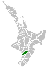
Location
"The Manawatu", as it is usually called, is located in the southwest of the island, close to the river which shares its name. Located north of WellingtonWellington
Wellington is the capital city and third most populous urban area of New Zealand, although it is likely to have surpassed Christchurch due to the exodus following the Canterbury Earthquake. It is at the southwestern tip of the North Island, between Cook Strait and the Rimutaka Range...
, the district stretches from slightly north of the settlement of Himatangi
Himatangi
Himatangi, formerly Carnarvon, is a small settlement in the Manawatu-Wanganui region of New Zealand's North Island. It is located at the junction of State Highways 1 and 56, 25 kilometres west of Palmerston North, and seven kilometres east of the coastal settlement of Himatangi Beach...
in the south to just south of Mangaweka
Mangaweka
Mangaweka is a township on State Highway One , in the North Island of New Zealand, with a population of just over 200. It is between Taihape to the north and Hunterville to the south...
in the north, and from the Rangitikei River
Rangitikei River
The Rangitikei River is one of New Zealand's longest rivers, 185 kilometers long.Its headwaters are to the southeast of Lake Taupo in the Kaimanawa Ranges. It flows from the Central Plateau south past Taihape, Mangaweka, Hunterville, Marton, and Bulls, to the South Taranaki Bight at Tangimoana, 40...
to the summit of the Tararua Ranges. The southern boundary follows the Manawatu River
Manawatu River
The Manawatu River is a major river of the southern North Island of New Zealand.The river has its headwaters to the northwest of Norsewood in the Ruahine Ranges of southern Hawke's Bay. It flows initially eastward before turning south-west near Ormondville, flowing 40 km before turning...
, and the district excludes the area around the city of Palmerston North
Palmerston North
Palmerston North is the main city of the Manawatu-Wanganui region of the North Island of New Zealand. It is an inland city with a population of and is the country's seventh largest city and eighth largest urban area. Palmerston North is located in the eastern Manawatu Plains near the north bank...
(including Ashhurst). The district has an area of 2,624 km².
Population
The population of the district is The main town and seat of the district council is FeildingFeilding, New Zealand
Feilding is a town in the Manawatu-Wanganui Region of the North Island of New Zealand. It is located on State Highway 54, 20 kilometres north of Palmerston North....
, which has a population of . Towns in the district include Halcombe, Himatangi, Bainesse, Bunnythorpe, Waituna West, Kimbolton, Apiti, Rangiwahia, Longburn, Rongotea, Pohangina
Pohangina
Pohangina is a small rural town in the Manawatu-Wanganui region of New Zealand.Pohangina has two parts to it; Pohangina Valley and Pohangina Village and it is just north of Ashhurst...
, Tangimoana, Himatangi Beach and Sanson
Sanson, New Zealand
Sanson is a small town in the Manawatu region of New Zealand. It is located just south of Bulls and the Rangitikei River, and west of the city of Palmerston North. The 2001 census revealed that Sanson's population was 495, a 4.6% decrease from the previous census in 1996...
.
Schools in Manawatu District
Secondary- Feilding High School - Feilding
- Longburn Adventist College - Longburn
- Hato Paora College - Cheltenham
Intermediate
- Feilding Intermediate School - Feilding
Primary
- Manchester Street School - Feilding
- Lytton Street School
- North Street School
- St Joseph's School
Local government
Manawatu District was formed through the amalgamation of the former Manawatu, Oroua, Kiwitea, Pohangina and part of Kairanga counties.The current mayor of the district is Ian McKelvie
Ian McKelvie
Ian McKelvie is a New Zealand politician and a member of the New Zealand House of Representatives. He is a member of the National Party.-Early life:McKelvie is the current mayor of the Manawatu District.He is the Board Chair of Special Olympics New Zealand....
There are three wards, each ward is represented on the council by three councillors.
The three wards are:
- Feilding
- Kairanga
- Kiwitea-Pohangina
Other uses
The term Manawatu (often the Manawatu) is also used to refer to a somewhat larger geographical region centred on the floodplain of the Manawatu RiverManawatu River
The Manawatu River is a major river of the southern North Island of New Zealand.The river has its headwaters to the northwest of Norsewood in the Ruahine Ranges of southern Hawke's Bay. It flows initially eastward before turning south-west near Ormondville, flowing 40 km before turning...
, with Palmerston North as its principal city. Like several other geographical regions, such as Wairarapa
Wairarapa
Wairarapa is a geographical region of New Zealand. It occupies the south-eastern corner of the North Island, east of metropolitan Wellington and south-west of the Hawke's Bay region. It is lightly populated, having several rural service towns, with Masterton being the largest...
and the King Country
King Country
The King Country is a region of the western North Island of New Zealand. It extends approximately from the Kawhia Harbour and the town of Otorohanga in the north to the upper reaches of the Whanganui River in the south, and from the Hauhungaroa and Rangitoto Ranges in the east to near the Tasman...
, the Manawatu in this sense never had precisely defined borders, its extents determined largely by custom and preference. Usually included were Palmerston North City and all or most of today's Manawatu and Horowhenua
Horowhenua District
Horowhenua is a district on the west coast of the North Island of New Zealand. It forms part of the Manawatu-Wanganui Region.Located north of Wellington and Kapiti, the district stretches from slightly north of the town of Otaki in the south to just south of Himatangi in the north, and from the...
Districts. Parts of the Rangitikei
Rangitikei District
The Rangitikei District is a Territorial Authority located primarily in the Manawatu-Wanganui Region in the North Island of New Zealand, although a small part, the town of Ngamatea , of it lies in the Hawke's Bay Region...
and/or Tararua
Tararua District
The Tararua District lies near the south-east corner of New Zealand's North Island. Created in 1989, it was named after the Tararua Range, which forms much of its western boundary. It has a population of and an area of 4,360.56 km²....
districts could also be included.