

Rangitikei District
Encyclopedia
| Rangitikei District | |
| Population: | 14,712 (territorial) |
| Mayor: | Chalky Leary |
| Deputy Mayor: | Andy Watson Andy Watson Andrew "Andy" Watson is a former professional footballer and current coach. During his playing career, Aberdeen-born Watson had spells at Leeds United, Hearts, Hibernian and Aberdeen. He joined the coaching staff at Hibs under Alex Miller and was persuaded by Alex McLeish, his former team mate at... |
| Urban Area | |
|---|---|
| Towns (inclusive): | Marton, Bulls, Hunterville, Mangaweka, Taihape |
| Territorial Authority | |
| Name: | Rangitikei District |
| Population: | 14,712 |
| Land area: | 4,479.42 km² (1,729.51 sq mi) |
| Extent: | Pukeokahu to Whangaehu; Turangarere to Rangitikei River |
| Website: | http://www.rangitikei.govt.nz |
| Regional Council | |
| Name: | Manawatu-Wanganui Manawatu-Wanganui Manawatu-Wanganui is a region in the lower half of the North Island of New Zealand, around the cities of Palmerston North and Whanganui. It is administered by the Horizons Regional Council.-Administration:... (Horizons Regional Council); Hawke's Bay Hawke's Bay Hawke's Bay is a region of New Zealand. Hawke's Bay is recognised on the world stage for its award-winning wines. The regional council sits in both the cities of Napier and Hastings.-Geography:... |
| Website: | http://www.horizons.govt.nz |
Territorial authorities of New Zealand
Territorial authorities are the second tier of local government in New Zealand, below regional councils. There are 67 territorial authorities: 13 city councils, 53 district councils, and the Chatham Islands Council...
located primarily in the Manawatu-Wanganui Region in the North Island
North Island
The North Island is one of the two main islands of New Zealand, separated from the much less populous South Island by Cook Strait. The island is in area, making it the world's 14th-largest island...
of New Zealand
New Zealand
New Zealand is an island country in the south-western Pacific Ocean comprising two main landmasses and numerous smaller islands. The country is situated some east of Australia across the Tasman Sea, and roughly south of the Pacific island nations of New Caledonia, Fiji, and Tonga...
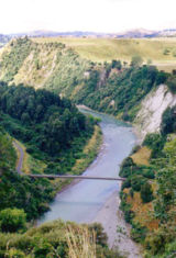
, although a small part, the town of Ngamatea (13.63% by land area), of it lies in the Hawke's Bay Region. It is located in the southwest of the island, and follows the catchment area of the Rangitikei River
Rangitikei River
The Rangitikei River is one of New Zealand's longest rivers, 185 kilometers long.Its headwaters are to the southeast of Lake Taupo in the Kaimanawa Ranges. It flows from the Central Plateau south past Taihape, Mangaweka, Hunterville, Marton, and Bulls, to the South Taranaki Bight at Tangimoana, 40...
.
Location
Located north of WellingtonWellington
Wellington is the capital city and third most populous urban area of New Zealand, although it is likely to have surpassed Christchurch due to the exodus following the Canterbury Earthquake. It is at the southwestern tip of the North Island, between Cook Strait and the Rimutaka Range...
, the district stretches from the South Taranaki Bight
South Taranaki Bight
The South Taranaki Bight is the name given to the large bay which extends south and east from the south coast of Taranaki in New Zealand's North Island. With more symmetry than poetry or originality, it is matched by the North Taranaki Bight to the north of Cape Egmont.The size of the bight...
toward the North Island Volcanic Plateau
North Island Volcanic Plateau
The North Island Volcanic Plateau is a volcanic plateau covering much of central North Island of New Zealand with volcanoes, lava plateaus, and crater lakes....
, forming a trapezium-shaped block that includes the towns of Taihape
Taihape
Taihape is the Northern gateway town of the Rangitikei District, located near the middle of the North Island of New Zealand. It services a large rural community and lies on State Highway 1, which runs through the centre of the North Island.- Economy :...
, Bulls
Bulls, New Zealand
Bulls is a small town near Palmerston North on the west coast of the North Island of New Zealand. It is in a thriving farming area in the Rangitikei District at the junction of State Highways 1 and 3 about 160 kilometres north of Wellington...
, Marton
Marton, New Zealand
Marton is the hub of the Rangitikei district of the Manawatu-Wanganui region of New Zealand's North Island. It is situated 35 kilometres southeast of Wanganui and 40 kilometres northwest of Palmerston North. The population was 4752 .-History:...
, Hunterville
Hunterville, New Zealand
Hunterville is a small community on State Highway 1, in the Rangitikei district of the North Island of New Zealand. It is located half way between Taupo and Wellington and has a population of 507....
, and Mangaweka
Mangaweka
Mangaweka is a township on State Highway One , in the North Island of New Zealand, with a population of just over 200. It is between Taihape to the north and Hunterville to the south...
. The district has an area of 4538 km².
Population
The population of the district was 14,712 at the 2006 census. The main town and seat of the district council is MartonMarton, New Zealand
Marton is the hub of the Rangitikei district of the Manawatu-Wanganui region of New Zealand's North Island. It is situated 35 kilometres southeast of Wanganui and 40 kilometres northwest of Palmerston North. The population was 4752 .-History:...
, which had a population of 4,680 at the 2006 census.
Schools in Rangitikei District
Secondary schools| School Name | Location |
|---|---|
| Rangitikei College | Marton Marton, New Zealand Marton is the hub of the Rangitikei district of the Manawatu-Wanganui region of New Zealand's North Island. It is situated 35 kilometres southeast of Wanganui and 40 kilometres northwest of Palmerston North. The population was 4752 .-History:... |
| Nga Tawa School Nga Tawa School Nga Tawa Diocesan School, also known as the Wellington Diocesan School for Girls, is an integrated, Anglican girls’ boarding school situated in the heart of the Rangitikei. It is found just outside the township of Marton in New Zealand.-History:... |
Marton Marton, New Zealand Marton is the hub of the Rangitikei district of the Manawatu-Wanganui region of New Zealand's North Island. It is situated 35 kilometres southeast of Wanganui and 40 kilometres northwest of Palmerston North. The population was 4752 .-History:... |
| Turakina Maori Girls' College Turakina Maori Girls' College Turakina Māori Girls' College is a Presbyterian boarding school for young Māori women. The school was originally founded in Turakina, in 1905, by A. G. Hamilton.It was relocated to Marton in 1927, but retained its previous name... (TMGC) |
Marton Marton, New Zealand Marton is the hub of the Rangitikei district of the Manawatu-Wanganui region of New Zealand's North Island. It is situated 35 kilometres southeast of Wanganui and 40 kilometres northwest of Palmerston North. The population was 4752 .-History:... |
| Taihape Area School | Taihape Taihape Taihape is the Northern gateway town of the Rangitikei District, located near the middle of the North Island of New Zealand. It services a large rural community and lies on State Highway 1, which runs through the centre of the North Island.- Economy :... |
History
The Whangaehu RiverWhangaehu River
The Whangaehu River is a large river in central North Island of New Zealand. Its headwaters are the crater lake of Mount Ruapehu on the central plateau, and it flows into the Tasman Sea eight kilometres southeast of Wanganui.-Length:...
partly runs through the northern extremity of the district. Its upper reaches were the scene of the Tangiwai disaster
Tangiwai disaster
The Tangiwai disaster on 24 December 1953 was the worst rail accident in New Zealand history. An 11-carriage overnight express from Wellington to Auckland fell into the Whangaehu River at Tangiwai, ten kilometres west of Waiouru. The bridge carrying the North Island Main Trunk Railway over the...
in 1953, New Zealand's worst rail disaster, in which 151 people lost their lives.