
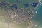
Waitara, New Zealand
Overview
North Island
The North Island is one of the two main islands of New Zealand, separated from the much less populous South Island by Cook Strait. The island is in area, making it the world's 14th-largest island...
of New Zealand
New Zealand
New Zealand is an island country in the south-western Pacific Ocean comprising two main landmasses and numerous smaller islands. The country is situated some east of Australia across the Tasman Sea, and roughly south of the Pacific island nations of New Caledonia, Fiji, and Tonga...
. Waitara is located just off State Highway 3
New Zealand State Highway network
The New Zealand State Highway network is the major national highway network in New Zealand. Just under 100 roads in both the North and South Islands are State Highways...
, 15 km northeast of New Plymouth.
The population was 6288 in the 2006 Census
New Zealand Census of Population and Dwellings
The New Zealand government department Statistics New Zealand conducts a census of population and dwellings every five years. The census scheduled for 2011 was cancelled due to circumstances surrounding the February 2011 Christchurch earthquake, however, and legislation introduced to hold the next...
, an increase of 42 from 2001.
The town was the site of the outbreak of the Taranaki Wars
First Taranaki War
The First Taranaki War was an armed conflict over land ownership and sovereignty that took place between Māori and the New Zealand Government in the Taranaki district of New Zealand's North Island from March 1860 to March 1861....
in 1860 following the attempted purchase of land for English settlers
Pakeha settlers
Pākehā settlers were European emigrants who journeyed to New Zealand, and more specifically to Auckland, the Wellington/Hawkes Bay region, Canterbury and Otago during the 19th century...
from its Māori owners.