
Masterton
Encyclopedia
Masterton is a large town and local government district in the Wellington Region
of New Zealand
. It is the largest town in the Wairarapa
, a region separated from Wellington by the Rimutaka ranges. It is 100 kilometres north-east of Wellington
, 28 kilometres south of Eketahuna
, on the Ruamahanga River
.
Masterton is a thriving community with an urban population of , and district population of
The Wairarapa Line
railway allows many residents easy access to work in the cities of Wellington
, Lower Hutt
and Upper Hutt
.
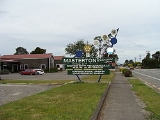
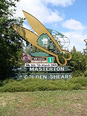
Local industries involve service industries for the surrounding farming community. Industrial development is growing in Masterton, with three new industrial parks being developed in Waingawa, Solway and Upper Plain. The town is the headquarters of the annual Golden Shears
sheep-shearing competition.
These include:
The Wairarapa Line
railway opened to Masterton on 1 November 1880.
Of the population, 10,869 (48.0%) were male, and 11,754 (52.0%) female. The district had a median age of 40.4 years, 4.5 years above the national median age of 35.9 years. People aged 65 years and over made up 16.8% of the population, compared to 12.3% nationally, and people under 15 years made up 21.3%, compared to 21.5% nationally.
Masterton's ethnicity was made up of (national figure in brackets): 77.9% European (67.6%), 16.9% Maori (14.7%), 1.7% Asian (9.2%), 2.7% Pacific Islanders (6.9%), 0.26% Middle Eastern/Latin American/African (0.9%), 12.1% 'New Zealanders' (11.1%), and 0.05% Other (0.04%).
Masterton had an unemployment rate of 4.8% of people 15 years and over, compared to 5.1% nationally. The median annual income of all people 15 years and over was $21,700, compared to $24,400 nationally. Of those, 46.7% earned under $20,000, compared to 43.2% nationally, while 12.3% earned over $50,000, compared to 18.0% nationally.
. Due to the geography of the Wairarapa valley and the Tararua Range
directly to the west, the town's temperature fluctuates more than nearby inland city of Palmerston North
. Masterton experiences warmer, dry summers with highs above 30°C possible and colder winters with frequent frost and lows below 0°C.
The Mayor of Masterton and five of the councillors are elected at large, while one councillor is elected from the Rural Ward (outside the Masterton urban area), and four are elected from the Urban Ward (Masterton urban area).
As of 12 May 2010, the current council members are:-
The vacant Urban Ward seat came following the death of councillor Jeff Workman on 11 May 2010. As the seat was vacated within six months of a planned election, a by-election
is not required and the seat will remain vacant until the 9 October 2010 election.
, Wainuiouru, Whareama), an intermediate school (Masterton Intermediate), and 6 secondary schools (Chanel College
, Makoura College
, Rathkeale College
, Solway College
, St Matthew's Collegiate, Wairarapa College). There is also a Māori immersion school, Te Kura Kaupapa Maori O Wairarapa.
Masterton has its own polytechnic, run by UCOL.
, formed by a merger between the Wairarapa Age and the Wairarapa Daily Times on April 1, 1938.
The Times-Age circulates throughout the greater Wairarapa region. The current senior management is Andrew Denholm, commercial manager, Louise Clark, advertising manager, Dave Saunders, editor and Kim Hildred, circulation and newspaper sales manager.
The Times-Age also published Wairarapa Midweek, a weekly community paper circulation 19,000.
The Wairarapa Times-Age is part of the APN newspaper group
.
Masterton and nearby Carterton
were the first towns in New Zealand to introduce the emergency number 111
, in September 1958.
Before the 1991 to 1993 changes, the area code for Masterton was 059. Today the area code is 06, and numbers begin with 370, 372, 377, 378, 379, and 946. 946 numbers are companies only.
Wairarapa's 89.5 / 105.5 / 105.9 MORE FM Wairarapa broadcasts locally from 6am to 1pm daily from studios in Kuripuni.
The station was founded by controversial Broadcaster Paul Henry, as TODAY FM 89.3 in Carterton in 1991. Later the station was rebranded as Hitz 89FM, Wairarapa's Best Music.
The MORE FM Breakfast Show has been hosted by well-known local broadcaster Brent Gare, since 2004.
The Saturday sports show at 8am has been hosted by local sports-caster Chris "Coggie" Cogdale since 1992.
Classic Hits 90.3 has a local breakfast show Mon to Friday 6 - 10am hosted by Jordan Brannigan, at all other times a network feed is taken from Classic Hits Auckland.
service providers based in Masterton, providing high speed broadband access to the towns and rural areas of the Wairarapa. WISE Net (purchased by Orcon Internet Limited
in 2006, and in January 2007 Canning & Associates purchased Orcon WiseNet Wireless Network) and WIZwireless LTD formerly Canning & Associates. ADSL access is widely available.
The main television transmitter for the town, and most of the southern half of the district, is the Otahoua transmitter atop Bennett's Hill, north-west of the town. TV3
transmits from the Popoiti transmitter east of Greytown
. In the northern half of the district, Palmerston North
's Mount Wharite transmitter provides the television service. Freeview HD is now available (via a UHF aerial) as of July 2011, broadcasting from the Popoiti transmitter near Greytown, Masterton residents will need to point their UHF aerial towards Popoiti to take advantage of the new service. Freeview is also available via satellite. Old Analogue Television will be switched off for Masterton at 2AM on Sunday 29 September 2013 .
, they are separated by the Rimutaka Range
s with State Highway 2
cutting a winding hill road through the range, and the Rimutaka railway tunnel
. Unlike other parts of the country, the Wairarapa has seen passenger rail services remain, largely due to its proximity to Wellington and the Rimutaka Tunnel's advantage over the Rimutaka Hill road. There has been talk of constructing a road tunnel through the ranges for decades, but this has been ruled out due to the extremely high cost. According to the latest transportation plan from the Greater Wellington Regional Council, the only work planned is for upgrades to the Rimutaka Hill road and the addition of passing lanes between Featherston
and Masterton.
passenger service run for Greater Wellington Region's Metlink
, primarily operating at peak times serving commuters from Masterton and the Wairarapa with five return services on Monday to Thursday, six on Friday and two at weekends and public holidays. There are three railway stations in the town; Masterton
, Renall Street
and Solway
.
bus service in Masterton operated by Tranzit. The buses operate on five routes: three suburban and two regional including:
There is also the MPN: Masterton to Palmerston North (via Woodville) service, not operated under the Metlink brand.
is south of Masterton. From early 2009 Air New Zealand provides flights to Auckland, operated by subsidiary Eagle Air six days a week, mainly to serve business customers in the Wairarapa. There have been a few unsuccessful attempts at commercial air travel in Masterton, mostly due to its proximity to major airports in Wellington and Palmerston North. The most significant was by South Pacific Airlines of New Zealand
(SPANZ), which operated daily flights using DC3
s during the sixties to destinations nationwide until the airline's closure in 1966.
, Japan Changchun
, China Armidale, New South Wales
, Australia
Wellington Region
The Wellington region of New Zealand occupies the southern end of the North Island.-Governance:The official Wellington Region, as administered by the Wellington Regional Council covers the conurbation around the capital city, Wellington, and the cities of Lower Hutt, Porirua, and Upper Hutt, each...
of New Zealand
New Zealand
New Zealand is an island country in the south-western Pacific Ocean comprising two main landmasses and numerous smaller islands. The country is situated some east of Australia across the Tasman Sea, and roughly south of the Pacific island nations of New Caledonia, Fiji, and Tonga...
. It is the largest town in the Wairarapa
Wairarapa
Wairarapa is a geographical region of New Zealand. It occupies the south-eastern corner of the North Island, east of metropolitan Wellington and south-west of the Hawke's Bay region. It is lightly populated, having several rural service towns, with Masterton being the largest...
, a region separated from Wellington by the Rimutaka ranges. It is 100 kilometres north-east of Wellington
Wellington
Wellington is the capital city and third most populous urban area of New Zealand, although it is likely to have surpassed Christchurch due to the exodus following the Canterbury Earthquake. It is at the southwestern tip of the North Island, between Cook Strait and the Rimutaka Range...
, 28 kilometres south of Eketahuna
Eketahuna
Eketahuna is a small rural service town, the most southerly in the Tararua District in the Manawatu-Wanganui region of the North Island of New Zealand, but is considered to be in northern Wairarapa. It was called Mellenskov, but was renamed soon after its founding.The town is located at the foot of...
, on the Ruamahanga River
Ruamahanga River
The Ruamahanga River runs through the southeastern North Island of New Zealand.The river's headwaters are in the Tararua Ranges northwest of Masterton. From there it runs firstly south and then southwest for 130 kilometers before emptying into the Cook Strait. The towns of Masterton and...
.
Masterton is a thriving community with an urban population of , and district population of
The Wairarapa Line
Wairarapa Line
The Wairarapa Line is a secondary railway line in the south-east of the North Island of New Zealand, connecting the capital city of Wellington with the Wairarapa region. The line ends at Woodville, where it joins the Palmerston North - Gisborne Line...
railway allows many residents easy access to work in the cities of Wellington
Wellington
Wellington is the capital city and third most populous urban area of New Zealand, although it is likely to have surpassed Christchurch due to the exodus following the Canterbury Earthquake. It is at the southwestern tip of the North Island, between Cook Strait and the Rimutaka Range...
, Lower Hutt
Lower Hutt
Lower Hutt is a city in the Wellington region of New Zealand. Its council has adopted the name Hutt City Council, but neither the New Zealand Geographic Board nor the Local Government Act recognise the name Hutt City. This alternative name can lead to confusion, as there are two cities in the...
and Upper Hutt
Upper Hutt
Upper Hutt is a satellite city of Wellington. It is New Zealand's smallest city by population, the second largest by land area. It is in Greater Wellington.-Geography:Upper Hutt is 30 km north-east of Wellington...
.
Local industries involve service industries for the surrounding farming community. Industrial development is growing in Masterton, with three new industrial parks being developed in Waingawa, Solway and Upper Plain. The town is the headquarters of the annual Golden Shears
Golden Shears
The Golden Shears Championship is the world's most prestigious sheep shearing event.It is held in March each year in Masterton, New Zealand, it is the culmination of the national shearing circuit....
sheep-shearing competition.
Suburbs
Despite the fact that Masterton is a town, not a city, it is still home to many suburbs.These include:
- In the northern part of town: Opaki, Lansdowne & Te Ore Ore.
- In the eastern part of town: Eastside & Homebush.
- In the western part of town: Upper Plain & Akura.
- In the southern part of town: Kuripuni, SolwaySolway, New ZealandSolway is a suburb in the southern part of Masterton, a large town in the Wairarapa Valley. Solway is the second largest suburb in the town after Lansdowne.-Education:...
.
History
Named after pioneer Joseph Masters, Masterton was first settled by Europeans on 21 May 1854. It gained borough status in 1877. It did not quite qualify to be a city by 1989 when the minimum population requirement for that status was lifted from 20,000 to 50,000.The Wairarapa Line
Wairarapa Line
The Wairarapa Line is a secondary railway line in the south-east of the North Island of New Zealand, connecting the capital city of Wellington with the Wairarapa region. The line ends at Woodville, where it joins the Palmerston North - Gisborne Line...
railway opened to Masterton on 1 November 1880.
Demographics
At the 2006 census, Masterton District had a population of 22,623, an increase of 6 people, <0.1 percent, since the 2001 census. There were 9030 occupied dwellings, 1248 unoccupied dwellings, and 123 dwellings under construction.Of the population, 10,869 (48.0%) were male, and 11,754 (52.0%) female. The district had a median age of 40.4 years, 4.5 years above the national median age of 35.9 years. People aged 65 years and over made up 16.8% of the population, compared to 12.3% nationally, and people under 15 years made up 21.3%, compared to 21.5% nationally.
Masterton's ethnicity was made up of (national figure in brackets): 77.9% European (67.6%), 16.9% Maori (14.7%), 1.7% Asian (9.2%), 2.7% Pacific Islanders (6.9%), 0.26% Middle Eastern/Latin American/African (0.9%), 12.1% 'New Zealanders' (11.1%), and 0.05% Other (0.04%).
Masterton had an unemployment rate of 4.8% of people 15 years and over, compared to 5.1% nationally. The median annual income of all people 15 years and over was $21,700, compared to $24,400 nationally. Of those, 46.7% earned under $20,000, compared to 43.2% nationally, while 12.3% earned over $50,000, compared to 18.0% nationally.
Climate
Masterton enjoys a mild temperate climate grading towards a Mediterranean climateMediterranean climate
A Mediterranean climate is the climate typical of most of the lands in the Mediterranean Basin, and is a particular variety of subtropical climate...
. Due to the geography of the Wairarapa valley and the Tararua Range
Tararua Range
The Tararua Range is one of several mountain ranges in the North Island of New Zealand which form a ridge running parallel with the east coast of the island between East Cape and Wellington....
directly to the west, the town's temperature fluctuates more than nearby inland city of Palmerston North
Palmerston North
Palmerston North is the main city of the Manawatu-Wanganui region of the North Island of New Zealand. It is an inland city with a population of and is the country's seventh largest city and eighth largest urban area. Palmerston North is located in the eastern Manawatu Plains near the north bank...
. Masterton experiences warmer, dry summers with highs above 30°C possible and colder winters with frequent frost and lows below 0°C.
Government
The Masterton District Council (MDC) governs the Masterton District territorial authority. It is made up of an elected mayor, a deputy mayor/councillor, and 9 additional councillors. They are elected under the First Past the Post system in triennial elections, with the next election being held on Saturday 9 October 2010.The Mayor of Masterton and five of the councillors are elected at large, while one councillor is elected from the Rural Ward (outside the Masterton urban area), and four are elected from the Urban Ward (Masterton urban area).
As of 12 May 2010, the current council members are:-
| Mayor | Garry Daniell |
| Councillors – General | Jane Terpstra (Deputy Mayor) Judith Callaghan Brent Goodwin David Holmes Chris Peterson |
| Councillors – Rural | Roddy McKenzie |
| Councillors – Urban | Jonathan Hooker Lyn Patterson Edwin Perry Edwin Perry Edwin Perry is a New Zealand politician. He is a member of the New Zealand First party.-Member of Parliament:He was first elected to Parliament as a list MP in the 2002 elections, having also stood in the Wairarapa electorate. He formerly held office in the National Party's organisational wing.... (vacant) |
The vacant Urban Ward seat came following the death of councillor Jeff Workman on 11 May 2010. As the seat was vacated within six months of a planned election, a by-election
By-election
A by-election is an election held to fill a political office that has become vacant between regularly scheduled elections....
is not required and the seat will remain vacant until the 9 October 2010 election.
Education
Following the reform of schools in 2004, the Masterton district has 12 primary schools (Douglas Park, Fernridge, Hadlow, Lakeview, Mauriceville, Masterton Primary, Opaki, Solway, St Patricks, TinuiTinui
Tinui is a small village approximately 40 kilometres from Masterton, in the Wairarapa, New Zealand. The name Tinui comes from the Māori words ti, meaning cabbage tree and nui, meaning many...
, Wainuiouru, Whareama), an intermediate school (Masterton Intermediate), and 6 secondary schools (Chanel College
Chanel College, Masterton
Chanel College, Masterton is a Catholic secondary school situated in Masterton, New Zealand. The school is named after St Peter Chanel, who was a French Marist priest killed on the Pacific island of Futuna in 1841. The school was established in 1978...
, Makoura College
Makoura College
Located in Masterton, New Zealand, Makoura College is a state co-educational secondary school, founded in 1968.-History:Makoura College was established in 1968 to cope with an expanding youth population in the Masterton district...
, Rathkeale College
Rathkeale College
Rathkeale College is a state-integrated Anglican boys secondary school on the outskirts of Masterton, New Zealand.-History:Rathkeale College was established in the 1960s to complete the family of schools managed by the St. Matthew's Schools Trust Board, which already had a girls school in St....
, Solway College
Solway College
Located in Masterton, New Zealand, Solway College is one of New Zealand's oldest girls' boarding schools, being founded in 1916. It is an integrated school for girls from Year 7 to Year 13 , offering a variety of boarding options and a limited number of day girl places.-Teaching Philosophy:The...
, St Matthew's Collegiate, Wairarapa College). There is also a Māori immersion school, Te Kura Kaupapa Maori O Wairarapa.
Masterton has its own polytechnic, run by UCOL.
Newspapers
The only daily newspaper based in Masterton is the Wairarapa Times-AgeWairarapa Times-Age
The Wairarapa Times-Age is the regional daily paper for the Wairarapa, including Masterton.-History:Of the first newspapers published in the region, the Wairarapa Mercury , the Wairarapa News, the Wairarapa Register and the Newsletter, all, except the Newsletter were forced to close down by fires...
, formed by a merger between the Wairarapa Age and the Wairarapa Daily Times on April 1, 1938.
The Times-Age circulates throughout the greater Wairarapa region. The current senior management is Andrew Denholm, commercial manager, Louise Clark, advertising manager, Dave Saunders, editor and Kim Hildred, circulation and newspaper sales manager.
The Times-Age also published Wairarapa Midweek, a weekly community paper circulation 19,000.
The Wairarapa Times-Age is part of the APN newspaper group
APN News & Media
APN News & Media Limited is an Australian and New Zealand media company. Divisions include newspaper publishing, online publishing, broadcast radio and outdoor advertising in Australia and New Zealand...
.
Telephone
The Masterton telephone exchange opened in 1897 with 53 subscribers. On 31 May 1919, Masterton became the first town in New Zealand to have a completely automatic (Rotary) telephone exchange.Masterton and nearby Carterton
Carterton, New Zealand
Carterton is a small town in the Wellington Region of New Zealand and the seat of the Carterton District. It lies in a farming area of the Wairarapa in New Zealand's North Island. It is located southwest of Masterton and northeast of Wellington...
were the first towns in New Zealand to introduce the emergency number 111
1-1-1
111 is the emergency telephone number in New Zealand. It was first implemented in Masterton and Carterton on 29 September 1958, and was progressively rolled out nationwide with the last exchanges converting in 1988...
, in September 1958.
Before the 1991 to 1993 changes, the area code for Masterton was 059. Today the area code is 06, and numbers begin with 370, 372, 377, 378, 379, and 946. 946 numbers are companies only.
Radio Stations
Masterton is serviced by two local radio stations.Wairarapa's 89.5 / 105.5 / 105.9 MORE FM Wairarapa broadcasts locally from 6am to 1pm daily from studios in Kuripuni.
The station was founded by controversial Broadcaster Paul Henry, as TODAY FM 89.3 in Carterton in 1991. Later the station was rebranded as Hitz 89FM, Wairarapa's Best Music.
The MORE FM Breakfast Show has been hosted by well-known local broadcaster Brent Gare, since 2004.
The Saturday sports show at 8am has been hosted by local sports-caster Chris "Coggie" Cogdale since 1992.
Classic Hits 90.3 has a local breakfast show Mon to Friday 6 - 10am hosted by Jordan Brannigan, at all other times a network feed is taken from Classic Hits Auckland.
Internet
In 2007 there were two wireless internetInternet
The Internet is a global system of interconnected computer networks that use the standard Internet protocol suite to serve billions of users worldwide...
service providers based in Masterton, providing high speed broadband access to the towns and rural areas of the Wairarapa. WISE Net (purchased by Orcon Internet Limited
Orcon Internet Limited
Orcon Internet Limited , is a state-owned New Zealand telecommunications company. It is currently New Zealand's fourth largest ISP.-History:...
in 2006, and in January 2007 Canning & Associates purchased Orcon WiseNet Wireless Network) and WIZwireless LTD formerly Canning & Associates. ADSL access is widely available.
Television
Masterton is serviced by all the major national television channels.The main television transmitter for the town, and most of the southern half of the district, is the Otahoua transmitter atop Bennett's Hill, north-west of the town. TV3
TV3 (New Zealand)
TV3 is a New Zealand commercial television network, owned by MediaWorks New Zealand. Launched on 26 November 1989, the first private television network in New Zealand...
transmits from the Popoiti transmitter east of Greytown
Greytown, New Zealand
Greytown or Te Hupenui, population 2,001 , is a town in the Wellington region of New Zealand. It lies in the Wairarapa, in the lower North Island...
. In the northern half of the district, Palmerston North
Palmerston North
Palmerston North is the main city of the Manawatu-Wanganui region of the North Island of New Zealand. It is an inland city with a population of and is the country's seventh largest city and eighth largest urban area. Palmerston North is located in the eastern Manawatu Plains near the north bank...
's Mount Wharite transmitter provides the television service. Freeview HD is now available (via a UHF aerial) as of July 2011, broadcasting from the Popoiti transmitter near Greytown, Masterton residents will need to point their UHF aerial towards Popoiti to take advantage of the new service. Freeview is also available via satellite. Old Analogue Television will be switched off for Masterton at 2AM on Sunday 29 September 2013 .
Transport
Masterton is very well served by public transport with rail, bus and air links. Despite Masterton and the Wairarapa valley being reasonably close to WellingtonWellington
Wellington is the capital city and third most populous urban area of New Zealand, although it is likely to have surpassed Christchurch due to the exodus following the Canterbury Earthquake. It is at the southwestern tip of the North Island, between Cook Strait and the Rimutaka Range...
, they are separated by the Rimutaka Range
Rimutaka Range
The Rimutaka Range is one of several mountain ranges in the North Island of New Zealand which form a ridge running parallel with the east coast of the island between East Cape and Wellington.The ridge is at its most pronounced in the southern part of the island, where it consists of the Ruahine,...
s with State Highway 2
New Zealand State Highway 2
State Highway 2 is one of New Zealand's eight national highways. With the exception of State Highway 1, which runs the length of both of the country's main islands, SH 2 is the longest highway in the North Island...
cutting a winding hill road through the range, and the Rimutaka railway tunnel
Rimutaka Tunnel
The Rimutaka Tunnel is a railway tunnel through New Zealand's Rimutaka Ranges, between Maymorn, near Upper Hutt, and Featherston, on the Wairarapa Line.The tunnel, which was opened to traffic on 3 November 1955, is long...
. Unlike other parts of the country, the Wairarapa has seen passenger rail services remain, largely due to its proximity to Wellington and the Rimutaka Tunnel's advantage over the Rimutaka Hill road. There has been talk of constructing a road tunnel through the ranges for decades, but this has been ruled out due to the extremely high cost. According to the latest transportation plan from the Greater Wellington Regional Council, the only work planned is for upgrades to the Rimutaka Hill road and the addition of passing lanes between Featherston
Featherston, New Zealand
Featherston is a town in the north of the Wellington Region region of New Zealand. It lies in the Wairarapa, just north of the Rimutaka Tunnel, in the South Wairarapa District. The population was 2,340 in the 2006 Census....
and Masterton.
Rail
Masterton is linked to Wellington and the Hutt Valley by the Wairarapa Connection, a Tranz MetroTranz Metro
Tranz Metro, part of KiwiRail, is the operator of Metlink suburban trains owned by the Greater Wellington Regional Council in the Wellington Region of New Zealand....
passenger service run for Greater Wellington Region's Metlink
Public transport in Wellington
Public transport in Wellington, the capital of New Zealand, is well developed compared to other parts of the country. The system covers the Greater Wellington region, including Wellington city, Lower Hutt, Upper Hutt, Porirua, the Kapiti Coast and the Wairarapa.-Administration:Public transport in...
, primarily operating at peak times serving commuters from Masterton and the Wairarapa with five return services on Monday to Thursday, six on Friday and two at weekends and public holidays. There are three railway stations in the town; Masterton
Masterton Railway Station
Masterton railway station is a single-platform, urban railway station serving the town of Masterton in the Wairarapa district of New Zealand. The station lies on the Wairarapa Line, and is located at the end of Perry Street. It is one hour, thirty seven minutes journey time to Wellington. Trains...
, Renall Street
Renall Street Railway Station
Renall Street railway station is an urban single-platform railway station on Renall Street in the Wairarapa town of Masterton in New Zealand’s North Island...
and Solway
Solway Railway Station
Solway railway station is an urban single-platform railway station in the Wairarapa town of Masterton in New Zealand’s North Island. It is on Ngaumutawa Road, between Hillcrest Street and Judds Road...
.
Bus
There is a local MetlinkPublic transport in Wellington
Public transport in Wellington, the capital of New Zealand, is well developed compared to other parts of the country. The system covers the Greater Wellington region, including Wellington city, Lower Hutt, Upper Hutt, Porirua, the Kapiti Coast and the Wairarapa.-Administration:Public transport in...
bus service in Masterton operated by Tranzit. The buses operate on five routes: three suburban and two regional including:
| Metlink Bus Services Public transport in Wellington Public transport in Wellington, the capital of New Zealand, is well developed compared to other parts of the country. The system covers the Greater Wellington region, including Wellington city, Lower Hutt, Upper Hutt, Porirua, the Kapiti Coast and the Wairarapa.-Administration:Public transport in... |
Termini |
|---|---|
| Route 200 Masterton/Featherston |
Wairarapa Hospital Featherston Station |
| Route 201 Masterton West |
Masterton – Church Street Worksop Road (Woolworths) |
| Route 202 Masterton South & East |
Masterton – Church Street Masterton – Church Street |
| Route 203 Masterton – Lansdowne Circuit |
Masterton – Church Street Worksop Road (Woolworths) |
| Route 205 Featherston/Martinborough |
Featherston Station Martinborough |
There is also the MPN: Masterton to Palmerston North (via Woodville) service, not operated under the Metlink brand.
Air
Hood AerodromeHood Aerodrome
Hood Aerodrome is an aerodrome, located in southern urban area of Masterton, New Zealand. The aerodrome was named after George Hood, a pioneer Masterton aviator who died trying to make the first Trans-Tasman crossing in 1928....
is south of Masterton. From early 2009 Air New Zealand provides flights to Auckland, operated by subsidiary Eagle Air six days a week, mainly to serve business customers in the Wairarapa. There have been a few unsuccessful attempts at commercial air travel in Masterton, mostly due to its proximity to major airports in Wellington and Palmerston North. The most significant was by South Pacific Airlines of New Zealand
South Pacific Airlines of New Zealand
South Pacific Airlines of New Zealand was a New Zealand airline, operating between 1960 and 1966. It is regarded as a forerunner to Ansett New Zealand.- History :...
(SPANZ), which operated daily flights using DC3
DC3
DC3 can refer to:* Device Control Three, one of the C0 and C1 control codes* DC3 a punk band formed by Dez Cadena after leaving Black Flag * DC3 is the name of a fictional band in the TV Show "Cory in the House"* Dark Castle 3, a video game...
s during the sixties to destinations nationwide until the airline's closure in 1966.
Sister cities
Masterton has Sister City relationships with: Hatsukaichi, HiroshimaHatsukaichi, Hiroshima
is a city of some 120,000 people located in Hiroshima Prefecture, Japan. The name derives from a market traditionally held on the 20th of each month with hatsuka meaning "20th day" and ichi translating to "market"...
, Japan Changchun
Changchun
Changchun is the capital and largest city of Jilin province, located in the northeast of the People's Republic of China, in the center of the Songliao Plain. It is administered as a sub-provincial city with a population of 7,677,089 at the 2010 census under its jurisdiction, including counties and...
, China Armidale, New South Wales
Armidale, New South Wales
Armidale is a city in the Northern Tablelands, New South Wales, Australia. Armidale Dumaresq Shire had a population of 19,485 people according to the 2006 census. It is the administrative centre for the Northern Tablelands region...
, Australia
See also
- Masterton Railway StationMasterton Railway StationMasterton railway station is a single-platform, urban railway station serving the town of Masterton in the Wairarapa district of New Zealand. The station lies on the Wairarapa Line, and is located at the end of Perry Street. It is one hour, thirty seven minutes journey time to Wellington. Trains...
- Renall Street Railway StationRenall Street Railway StationRenall Street railway station is an urban single-platform railway station on Renall Street in the Wairarapa town of Masterton in New Zealand’s North Island...
- Solway Railway StationSolway Railway StationSolway railway station is an urban single-platform railway station in the Wairarapa town of Masterton in New Zealand’s North Island. It is on Ngaumutawa Road, between Hillcrest Street and Judds Road...