
Waipa District
Encyclopedia
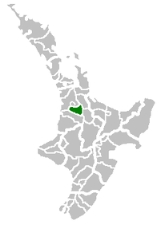
Waipa District Council in the Waikato region
of New Zealand
is a municipality
that covers Te Awamutu
, Cambridge
and several small towns. The seat of the council is at Te Awamutu. The district's population at the was , of whom approximately 35% lived in each of the main two towns. The district has a land area of 1,473.47 km² (568.91 sq mi). It has five wards: Te Awamutu, Cambridge, Pirongia
, Maungatautari and Kakepuku.
The district is located due south of the city of Hamilton
. The region's economy is based largely on dairy
farming and cereal
production. The southeastern corner of the district includes the hydroelectric
project at Karapiro
.
Waikato
The Waikato Region is a local government region of the upper North Island of New Zealand. It covers the Waikato, Hauraki, Coromandel Peninsula, the northern King Country, much of the Taupo District, and parts of Rotorua District...
of New Zealand
New Zealand
New Zealand is an island country in the south-western Pacific Ocean comprising two main landmasses and numerous smaller islands. The country is situated some east of Australia across the Tasman Sea, and roughly south of the Pacific island nations of New Caledonia, Fiji, and Tonga...
is a municipality
Municipality
A municipality is essentially an urban administrative division having corporate status and usually powers of self-government. It can also be used to mean the governing body of a municipality. A municipality is a general-purpose administrative subdivision, as opposed to a special-purpose district...
that covers Te Awamutu
Te Awamutu
Te Awamutu is a town in the Waikato in the North Island of New Zealand. It is the council seat of the Waipa District and serves as a service town for the farming communities which surround it...
, Cambridge
Cambridge, New Zealand
Cambridge is a town in the Waikato region of the North Island of New Zealand. Situated 24 kilometres southeast of Hamilton, on the banks of the Waikato River, Cambridge is known as "The Town of Trees & Champions".In the 1840s Cambridge had a Maori population but in the 1850's missionaries and...
and several small towns. The seat of the council is at Te Awamutu. The district's population at the was , of whom approximately 35% lived in each of the main two towns. The district has a land area of 1,473.47 km² (568.91 sq mi). It has five wards: Te Awamutu, Cambridge, Pirongia
Pirongia
Pirongia is a small town in the Waipa District of the Waikato region of New Zealand's North Island.It is 12 kilometres to the west of Te Awamutu, on the banks of the Waipa River, close to the foot of the 962 metre Mount Pirongia, which lies in a forest park to the west of the town.Pirongia was...
, Maungatautari and Kakepuku.
The district is located due south of the city of Hamilton
Hamilton, New Zealand
Hamilton is the centre of New Zealand's fourth largest urban area, and Hamilton City is the country's fourth largest territorial authority. Hamilton is in the Waikato Region of the North Island, approximately south of Auckland...
. The region's economy is based largely on dairy
Dairy
A dairy is a business enterprise established for the harvesting of animal milk—mostly from cows or goats, but also from buffalo, sheep, horses or camels —for human consumption. A dairy is typically located on a dedicated dairy farm or section of a multi-purpose farm that is concerned...
farming and cereal
Cereal
Cereals are grasses cultivated for the edible components of their grain , composed of the endosperm, germ, and bran...
production. The southeastern corner of the district includes the hydroelectric
Hydroelectricity
Hydroelectricity is the term referring to electricity generated by hydropower; the production of electrical power through the use of the gravitational force of falling or flowing water. It is the most widely used form of renewable energy...
project at Karapiro
Lake Karapiro
Lake Karapiro is an artificial reservoir lake on the Waikato River in the North Island of New Zealand. The lake, near Cambridge and some south-east of the city of Hamilton, was created in 1947 to store water for the Karapiro Power Station, the last of the eight hydroelectric power stations on the...
.