

Stratford, New Zealand
Encyclopedia
| Stratford | |
| Country: | New Zealand New Zealand New Zealand is an island country in the south-western Pacific Ocean comprising two main landmasses and numerous smaller islands. The country is situated some east of Australia across the Tasman Sea, and roughly south of the Pacific island nations of New Caledonia, Fiji, and Tonga... |
| Population: | 5,327 (Stratford town) 8,889 (territorial) (2006 census) |
| Urban Area | |
|---|---|
| Extent: | |
| Territorial Authority | |
| Name: | Stratford District |
| Mayor: | Neil Volzke |
| Deputy Mayor: | Roger Hignett |
| Extent: | |
| Land area: | 2163.35 km² (835.27 sq mi) |
| Website: | http://www.stratford.govt.nz |
| See also: | South Taranaki South Taranaki District South Taranaki is a territorial authority on the west coast of New Zealand's North Island that contains the towns of Hawera, Manaia, Opunake, Patea, Eltham, and Waverley... , New Plymouth New Plymouth New Plymouth is the major city of the Taranaki Region on the west coast of the North Island of New Zealand. It is named after Plymouth, Devon, England, from where the first English settlers migrated.... |
| Regional Council | |
| Name: | Taranaki Regional Council and Manawatu-Wanganui Regional Council Manawatu-Wanganui Manawatu-Wanganui is a region in the lower half of the North Island of New Zealand, around the cities of Palmerston North and Whanganui. It is administered by the Horizons Regional Council.-Administration:... |
| Websites: | http://www.trc.govt.nz http://www.horizons.govt.nz |
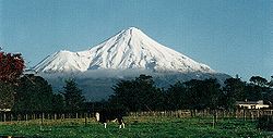
Stratford is the only town in the central Taranaki district of Stratford District, New Zealand
New Zealand
New Zealand is an island country in the south-western Pacific Ocean comprising two main landmasses and numerous smaller islands. The country is situated some east of Australia across the Tasman Sea, and roughly south of the Pacific island nations of New Caledonia, Fiji, and Tonga...
. It lies beneath the eastern slopes of Mount Taranaki/Egmont, approximately half-way between New Plymouth
New Plymouth
New Plymouth is the major city of the Taranaki Region on the west coast of the North Island of New Zealand. It is named after Plymouth, Devon, England, from where the first English settlers migrated....
and Hawera
Hawera
Hawera is the second-largest town in the Taranaki region of New Zealand's North Island, with a population of . It is near the coast of the South Taranaki Bight, 75 kilometres south of New Plymouth on State Highway 3 and 20 minutes' drive from Mount Taranaki/Egmont.It is also on State Highway 45,...
, near the geographic centre of the Taranaki region. The town has a population of 5,327, and the district 8,889. The District has a land area of 2,163.35 km², which is divided between the Manawatu-Wanganui
Manawatu-Wanganui
Manawatu-Wanganui is a region in the lower half of the North Island of New Zealand, around the cities of Palmerston North and Whanganui. It is administered by the Horizons Regional Council.-Administration:...
Region (including the settlements of Whangamomona
Whangamomona
Whangamomona is a small township in the Stratford District and Manawatu-Wanganui Region in New Zealand. It lies on State Highway 43, the Lost World Highway north-east of Stratford and south-west of Ohura. By rail it is from Stratford on the Stratford-Okahukura railway line.- History :The first...
, Marco
Marco, New Zealand
Marco is a settlement in the Stratford District and the Taranaki Region, in the western North Island of New Zealand. It is located to the northeast of Whangamomona on State Highway 43. The Whangamomona River flows through the area...
and Tahora, 31.87% of its land area) and the Taranaki Region (68.13% of its land area).
The elevation of the town centre is 312m above sea level.
Stratford is home to the headquarters of the Taranaki Regional Council.
Road & Rail
Stratford is at the junction of State Highway 3 and State Highway 43New Zealand State Highway network
The New Zealand State Highway network is the major national highway network in New Zealand. Just under 100 roads in both the North and South Islands are State Highways...
.
On State Highway 3 New Plymouth
New Plymouth
New Plymouth is the major city of the Taranaki Region on the west coast of the North Island of New Zealand. It is named after Plymouth, Devon, England, from where the first English settlers migrated....
is 39 km north, Inglewood
Inglewood, New Zealand
Inglewood is a town in the Taranaki Region of New Zealand's North Island. The population was 3,090 in the 2006 Census, an increase of 144 from 2001. Inglewood lies 200m above sea level....
21 km north, Eltham
Eltham, New Zealand
thumb|left|The town center of ElthamEltham is a small inland town in South Taranaki, New Zealand, located 50 km south of the city of New Plymouth and southeast of the volcanic cone of Mount Taranaki/Egmont. Stratford is 11 km north, Kaponga 13 km west, and Hawera 19 km south....
11 km south and Hawera
Hawera
Hawera is the second-largest town in the Taranaki region of New Zealand's North Island, with a population of . It is near the coast of the South Taranaki Bight, 75 kilometres south of New Plymouth on State Highway 3 and 20 minutes' drive from Mount Taranaki/Egmont.It is also on State Highway 45,...
30 km south.
On State Highway 43 Taumarunui
Taumarunui
Taumarunui is a town in the King Country of the central North Island of New Zealand. It is on State Highway 4 and the North Island Main Trunk Railway....
is 146 km to the east. This road is known as "The Forgotten World Highway", due the scarcity of settlement along the road in contrast to its earlier history. A sign reads "No Petrol for 140 km".
Stratford railway station is the junction of the Marton-New Plymouth and Stratford - Okahukura lines.
Physical Geography
Patea River
The Patea River is in Taranaki in the North Island of New Zealand. It runs for 105 kilometres from the eastern slopes of Mount Taranaki, passing east through Stratford before swinging south and reaching the South Taranaki Bight near the town of Patea....
catchment
Drainage basin
A drainage basin is an extent or an area of land where surface water from rain and melting snow or ice converges to a single point, usually the exit of the basin, where the waters join another waterbody, such as a river, lake, reservoir, estuary, wetland, sea, or ocean...
, and the eastern hill country.
Taranaki Volcanic Cone
The south-eastern face of Mount Taranaki is in the Stratford district, the north-westernmost point of the district being the 2518 m high peak. From the peak the boundaries run almost due east and due south.Pembroke Road winds up the mountain slope from Stratford to a carpark and lookout at "The Plateau", at 1172 m. Manganui skifield
Manganui
Manganui Ski Area, located in Taranaki, in New Zealand's North Island is a club skifield. Like all club fields, it has accommodation onsite, in the form of the 33-bed Manganui Lodge. It has 3 rope ski tows and a T-bar covering a beginner-intermediate terrain of 59 hectares. The elevation ranges...
is a short hike from the carpark, across the Manganui Gorge.
On the south-eastern face of the mountain, Manaia Road gives access to Dawson Falls and the Konini Lodge, at 890 m altitude. The natural Wilkies Pools are a short hike above the lodge.
Taranaki Volcanic Ring Plain
The Taranaki volcanic ring plain provides a steady contour with a subtle gradient, upon which Stratford and its environs have been settled. The easy gradient and rich volcanic soils and the high level of rainfall provide high quality pasturePasture
Pasture is land used for grazing. Pasture lands in the narrow sense are enclosed tracts of farmland, grazed by domesticated livestock, such as horses, cattle, sheep or swine. The vegetation of tended pasture, forage, consists mainly of grasses, with an interspersion of legumes and other forbs...
and agricultural land. Within this area the ring plain is drained by three river catchments: the Manganui River
Manganui River, Taranaki
The southernmost of New Zealand's Manganui Rivers flows through the Taranaki Region of New Zealand's North Island. It initially flows east from its sources on the slopes of Taranaki/Mount Egmont, turning north close to Midhirst and joining with the waters of the Waitara River ten kilometres from...
catchment to the north, the Waingongoro River
Waingongoro River
The Waingongoro River is a river of the Taranaki Region of New Zealand's North Island. It flows initially southeast from the slopes of Taranaki/Mount Egmont and passes through the town of Eltham before veering southwest to reach the coast five kilometres west of Hawera.-References:...
catchment to the south, and the dominant Patea River
Patea River
The Patea River is in Taranaki in the North Island of New Zealand. It runs for 105 kilometres from the eastern slopes of Mount Taranaki, passing east through Stratford before swinging south and reaching the South Taranaki Bight near the town of Patea....
catchment.
Patea River
The headwaters of the Patea RiverPatea River
The Patea River is in Taranaki in the North Island of New Zealand. It runs for 105 kilometres from the eastern slopes of Mount Taranaki, passing east through Stratford before swinging south and reaching the South Taranaki Bight near the town of Patea....
are on the eastern face of Mount Taranaki, above Stratford. From there the river flows eastwards, its upper catchment taking in a narrow area of land between the Manganui River catchment to the north and the Waingongoro River
Waingongoro River
The Waingongoro River is a river of the Taranaki Region of New Zealand's North Island. It flows initially southeast from the slopes of Taranaki/Mount Egmont and passes through the town of Eltham before veering southwest to reach the coast five kilometres west of Hawera.-References:...
catchment to the south.
Stratford is on the banks of the Patea River
Patea River
The Patea River is in Taranaki in the North Island of New Zealand. It runs for 105 kilometres from the eastern slopes of Mount Taranaki, passing east through Stratford before swinging south and reaching the South Taranaki Bight near the town of Patea....
, at the junction of the Patea River and Paetahi Stream, approximately 15 km east of the headwaters. Due to the narrow width of the catchment, the southern boundary of the town is on the Patea/Waingongoro divide
Water divide
A drainage divide, water divide, divide or watershed is the line separating neighbouring drainage basins...
, while 4 km to the north Midhirst
Midhirst
Midhirst is a small village in Taranaki, New Zealand, approximately 4 km north of Stratford, on State Highway 3. Inglewood is 17 km north of Midhirst, and New Plymouth is 35 km to the northwest....
is on the Patea/Manganui divide.
Beyond Stratford the catchment widens significantly to include a number of ancient swamps, including Ngaere
Ngaere
Ngaere is a village situated on State Highway 3, 4 kilometres south of Stratford, New Zealand. The name Ngaere literally means "swamp" in English, and before settlement, the area was covered by a vast and ancient wetland....
and Toko
Toko
Toko is a small rural settlement 10 kilometres east of Stratford, New Zealand, at the intersection of East Road and Toko Road. It is located on a railway, the Stratford - Okahukura Line, the western portion of which was operated as a branch line known as the Toko Branch prior to the line's...
, and also the Kahouri and Piakau ring plain streams. The river then takes in the expansive eastern hill country catchments of the Toko, Makuri
Makuri Stream
The Makuri Stream is a tributary of the Patea River, in the upper catchment among the eastern Taranaki hill country. The Makuri catchment falls entirely within the Stratford district, and takes in the settlements of Huinga, Huiroa and Kiore....
, Mangaehu, Mangaotuku, Puniwhakau and Makahu Streams, before winding its way southwards through the hills of the South Taranaki
South Taranaki District
South Taranaki is a territorial authority on the west coast of New Zealand's North Island that contains the towns of Hawera, Manaia, Opunake, Patea, Eltham, and Waverley...
district, to its mouth at Patea
Patea
Patea is the third-largest town in South Taranaki, New Zealand. It is on the western bank of the Patea River, 61 kilometres north-west of Wanganui on State Highway 3. Hawera is 27 km to the north-west, and Waverley 17 km to the east. The Patea River flows through the town from the...
.
Eastern hill country
Beyond Stratford the district extends approximately 45 km to the east, between the Waitara RiverWaitara River
The source of the Waitara River lies in the very steep hill country to the east of Mount Taranaki/Egmont, near Tahora. After proceeding in a southwesterly direction toward Central Taranaki, the river abruptly turns to flow in a northeasterly direction to the Tasman Sea: meeting it at the coastal...
to the north and the Matemateaonga Ranges to the south, with the Whanganui River
Whanganui River
The Whanganui River is a major river in the North Island of New Zealand.Known for many years as the Wanganui River, the river's name reverted to Whanganui in 1991, according with the wishes of local iwi. Part of the reason was also to avoid confusion with the Wanganui River in the South Island...
and Heao Stream constituting much of the district's eastern boundary. This area is dominated by steep sandstone
Sandstone
Sandstone is a sedimentary rock composed mainly of sand-sized minerals or rock grains.Most sandstone is composed of quartz and/or feldspar because these are the most common minerals in the Earth's crust. Like sand, sandstone may be any colour, but the most common colours are tan, brown, yellow,...
, greywacke
Greywacke
Greywacke or Graywacke is a variety of sandstone generally characterized by its hardness, dark color, and poorly sorted angular grains of quartz, feldspar, and small rock fragments or lithic fragments set in a compact, clay-fine matrix. It is a texturally immature sedimentary rock generally found...
and mudstone
Mudstone
Mudstone is a fine grained sedimentary rock whose original constituents were clays or muds. Grain size is up to 0.0625 mm with individual grains too small to be distinguished without a microscope. With increased pressure over time the platey clay minerals may become aligned, with the...
hills and winding valleys. Much of the steep and isolated hill country is in native or exotic forestry. The remainder of the district is in sheep
Sheep husbandry
Sheep husbandry is a subcategory of animal husbandry specifically dealing with the raising and breeding of domestic sheep. Sheep farming is primarily based on raising lambs for meat, or raising sheep for wool. Sheep may also be raised for milk or to sell to other farmers.-Shelter and...
and/or beef
Beef
Beef is the culinary name for meat from bovines, especially domestic cattle. Beef can be harvested from cows, bulls, heifers or steers. It is one of the principal meats used in the cuisine of the Middle East , Australia, Argentina, Brazil, Europe and the United States, and is also important in...
pastoral farming
Pastoral farming
Pastoral farming is farming aimed at producing livestock, rather than growing crops. Examples include dairy farming, raising beef cattle, and raising sheep for wool. In contrast, mixed farming is growing of both crops and livestock on the same farm. Pastoral farmers are also known as graziers...
.
Much of the eastern hill country falls within the catchment of the Patea River and its tributaries. However, to the north the district takes in Waitara River
Waitara River
The source of the Waitara River lies in the very steep hill country to the east of Mount Taranaki/Egmont, near Tahora. After proceeding in a southwesterly direction toward Central Taranaki, the river abruptly turns to flow in a northeasterly direction to the Tasman Sea: meeting it at the coastal...
and its tributaries, including the Makara, Makino, Matau, Mangapapa and Mangaowata catchments. At its northernmost point the district also includes the Mt Damper Stream and its associated swamp and falls, which feed into the Tongaporutu River
Tongaporutu River
The Tongaporutu River is a river of the Taranaki Region of New Zealand's North Island. It initially flows north from its origins near Tahora, turning west to reach the Tasman Sea coast close to the settlement of Tongaporutu, 15 kilometres south of Mokau....
.
In the east the district takes in the Whangamomona River
Whangamomona River
The Whangamomona River is a river of the Manawatu-Wanganui Region of New Zealand's North Island. It flows generally southeast from its sources near Whangamomona before turning east to reach the Whanganui River.-References:...
catchment, and also most of the Tangarakau River
Tangarakau River
The Tangarakau River is a river of the Taranaki and Manawatu-Wanganui Regions of New Zealand's North Island. It flows south from its sources to the northeast of Whangamomona in the King Country to reach the Whanganui River....
catchment, both of which feed into the Whanganui River
Whanganui River
The Whanganui River is a major river in the North Island of New Zealand.Known for many years as the Wanganui River, the river's name reverted to Whanganui in 1991, according with the wishes of local iwi. Part of the reason was also to avoid confusion with the Wanganui River in the South Island...
. This area is separated from the west by the densely forested Whangamomona Saddle, making it an isolated and distinctive part of the district, and the area once had its own county council.
To the south-east the district also takes in the upper reaches of the Waitotara River
Waitotara River
The Waitotara River in New Zealand's North Island stretches approximately 100km in length from its headwaters in the Matemateaonga Ranges to its mouth on the South Taranaki Bight...
catchment, within the Matemateaonga Ranges and the Waitotara Conservation Area.
Surrounding Settlements
Stratford is surrounded by a number of small villages and settlements. To the north on State Highway 3 are MidhirstMidhirst
Midhirst is a small village in Taranaki, New Zealand, approximately 4 km north of Stratford, on State Highway 3. Inglewood is 17 km north of Midhirst, and New Plymouth is 35 km to the northwest....
and beyond that Waipuku
Waipuku
Waipuku is a settlement in inland Taranaki, in the western North Island of New Zealand. It is located between Stratford and Inglewood on State Highway 3.-General historical works:...
, and to the south is the locality of Ngaere
Ngaere
Ngaere is a village situated on State Highway 3, 4 kilometres south of Stratford, New Zealand. The name Ngaere literally means "swamp" in English, and before settlement, the area was covered by a vast and ancient wetland....
. Cardiff
Cardiff, New Zealand
Cardiff is a settlement in inland Taranaki, in the western North Island of New Zealand. It is located five kilometres southwest of Stratford close to Egmont National Park.-Business history:...
, Mahoe, Rowan and Pembroke
Pembroke, Taranaki
Pembroke is a settlement in inland Taranaki, in the western North Island of New Zealand. It is located about 5 km northwest of Stratford.The population of the Pembroke statistical area was 1203 in the 2006 Census, a decrease of 15 from 2001...
are beneath the mountain to the west, and Wharehuia, Tuna, Te Popo
Te Popo
Te Popo is a settlement in inland Taranaki, in the western North Island of New Zealand. It is located ten kilometres northeast of Stratford.-Business history:...
and Kupe are to the north-east.
To the east, along State Highway 43 and the Stratford-Okahukura railway, lie settlements that in their heyday were bustling villages. Toko
Toko
Toko is a small rural settlement 10 kilometres east of Stratford, New Zealand, at the intersection of East Road and Toko Road. It is located on a railway, the Stratford - Okahukura Line, the western portion of which was operated as a branch line known as the Toko Branch prior to the line's...
and the renowned Whangamomona
Whangamomona
Whangamomona is a small township in the Stratford District and Manawatu-Wanganui Region in New Zealand. It lies on State Highway 43, the Lost World Highway north-east of Stratford and south-west of Ohura. By rail it is from Stratford on the Stratford-Okahukura railway line.- History :The first...
have retained their character as villages, while the settlements of Douglas
Douglas, Taranaki
Douglas is a lowly populated locality and a rural centre in east Taranaki, surrounded by dairy, sheep and beef pastoral farming. It is situated 18 km east of Stratford at the intersection of East Road, Ohura Road, Douglas Road South and Bredow Road. East Road and Ohura Road meet to form State...
, Strathmore, Huiakama
Huiakama
Huiakama is a settlement in inland Taranaki, in the western North Island of New Zealand. It is located just to the north of Strathmore on State Highway 43.-Education:...
, Te Wera, Pohokura, Marco
Marco, New Zealand
Marco is a settlement in the Stratford District and the Taranaki Region, in the western North Island of New Zealand. It is located to the northeast of Whangamomona on State Highway 43. The Whangamomona River flows through the area...
, Kohuratahi and Tahora now consist of no more than a few houses. Along roads off State Highway 3 are a number of other settlements, some of which were also once bustling villages. Huiroa
Huiroa
Huiroa is a settlement in inland Taranaki, in the western North Island of New Zealand. It is located 20 kilometres east of Stratford and eight kilometres north of Douglas.-Schools: Category:Stratford District...
, Kiore, Matau and Mt. Damper are to the north and west of the highway, and Huinga, Tututawa
Tututawa
Tututawa is a locality and rural centre in east Taranaki, New Zealand, 26 km east of Stratford, with a population of approximately 40. The settlement is centred 5 km south of Ohura Road , at the intersection of Mangaotuku Road and Tututawa Road. Positioned approximately 150m above sea level,...
, Puniwhakau, Makahu
Makahu
Makahu is a settlement in inland Taranaki, in the western North Island of New Zealand. It is located to the southeast of Strathmore. the Makahu Stream runs south through the area to join with the Mangaehu Stream, which flows into the Patea River....
, Aotuhia and Tangarakau are to the south and east.
National Parks
Stratford is the gateway to two National Parks - Egmont National ParkEgmont National Park
Egmont National Park is located south of New Plymouth, close to the west coast of the North Island of New Zealand. It is named after the mountain which dominates its environs, which itself was named by Captain Cook after John Perceval, 2nd Earl of Egmont, the First Lord of the Admiralty who...
to the west, and Whanganui National Park
Whanganui National Park
The Whanganui National Park is a national park located in the North Island of New Zealand. Established in 1986, it covers an area of 742 km² bordering the Whanganui River. It incorporates areas of Crown land, former state forest and a number of former reserves. The river itself is not part of the...
to the east (via Kohi Saddle, Aotuhia).
Population
Stratford is a rural service centre, serving the agricultural economy of its wider hinterland.After a period of decline, the last five years have seen significant economic growth and some associated population growth in the town. In the 2006 census the district population was 8889, with 5327 in the township and 3562 in the surrounding rural area. This was the first time that the town had recorded population growth since the 1991 census.
The population of the district peaked in 1961 at 11,300, and since then the town has fluctuated between 5229 (2001) and 5664 (1996).
Economy
The Egmont Ring Plain provides steady contours and fertile volcanic soils which, together with the high level of rainfall, make for some of the best dairyDairy
A dairy is a business enterprise established for the harvesting of animal milk—mostly from cows or goats, but also from buffalo, sheep, horses or camels —for human consumption. A dairy is typically located on a dedicated dairy farm or section of a multi-purpose farm that is concerned...
country in New Zealand
New Zealand
New Zealand is an island country in the south-western Pacific Ocean comprising two main landmasses and numerous smaller islands. The country is situated some east of Australia across the Tasman Sea, and roughly south of the Pacific island nations of New Caledonia, Fiji, and Tonga...
. The district is predominantly dairying (57,300 dairy cattle), while the rolling to steep eastern hill country supports dry stock farming and forestry (42,000 beef
Beef
Beef is the culinary name for meat from bovines, especially domestic cattle. Beef can be harvested from cows, bulls, heifers or steers. It is one of the principal meats used in the cuisine of the Middle East , Australia, Argentina, Brazil, Europe and the United States, and is also important in...
cattle; 281,300 sheep
Sheep husbandry
Sheep husbandry is a subcategory of animal husbandry specifically dealing with the raising and breeding of domestic sheep. Sheep farming is primarily based on raising lambs for meat, or raising sheep for wool. Sheep may also be raised for milk or to sell to other farmers.-Shelter and...
).
The energy
Energy
In physics, energy is an indirectly observed quantity. It is often understood as the ability a physical system has to do work on other physical systems...
and tourism
Tourism
Tourism is travel for recreational, leisure or business purposes. The World Tourism Organization defines tourists as people "traveling to and staying in places outside their usual environment for not more than one consecutive year for leisure, business and other purposes".Tourism has become a...
industries are both of growing significance to the Stratford District. The Stratford Power Station
Stratford Power Station
The Stratford Power Station is a 575 MW power station located east of Stratford, Taranaki, New Zealand. It comprises one combined cycle unit and two open cycle gas turbine units and is owned and operated by Contact Energy.- History :...
is located 3 km east of the town.
Whakaahurangi
The MāoriMaori language
Māori or te reo Māori , commonly te reo , is the language of the indigenous population of New Zealand, the Māori. It has the status of an official language in New Zealand...
name for Stratford is Whakaahurangi, meaning face to the sky. The name is taken from a story of a Patea
Patea
Patea is the third-largest town in South Taranaki, New Zealand. It is on the western bank of the Patea River, 61 kilometres north-west of Wanganui on State Highway 3. Hawera is 27 km to the north-west, and Waverley 17 km to the east. The Patea River flows through the town from the...
chieftainess named Ruapu-tahanga who, returning from a visit to Kawhia, camped overnight near the location of the current town. Being a clear night, Ruaputahanga lay contemplating the stars when slumber overtook her. Withdrawing in respect, her followers observed that their chieftainess slept “with her face to the sky”. The site continued to be used as a camping place for Māori along what became known as the Whakaahurangi track, linking the south Taranaki
South Taranaki District
South Taranaki is a territorial authority on the west coast of New Zealand's North Island that contains the towns of Hawera, Manaia, Opunake, Patea, Eltham, and Waverley...
tribes to those in north Taranaki, and further north to Kawhia. Each traveling party would recollect the story of Ruapu-tahanga sleeping with her face to the sky. The name is fitting, given the exposure of the area to a broad horizon on the face of the mountain’s ring plain.
Surveying
There is no record of Māori settlement in the vicinity of Stratford. Before BritishBritish Empire
The British Empire comprised the dominions, colonies, protectorates, mandates and other territories ruled or administered by the United Kingdom. It originated with the overseas colonies and trading posts established by England in the late 16th and early 17th centuries. At its height, it was the...
settlement the area was covered in dense forest and swamp. The Vogel schemes
Julius Vogel
Sir Julius Vogel, KCMG was the eighth Premier of New Zealand. His administration is best remembered for the issuing of bonds to fund railway construction and other public works...
of the 1870s provided the necessary impetus to lead to the construction of a railway line south of New Plymouth
New Plymouth
New Plymouth is the major city of the Taranaki Region on the west coast of the North Island of New Zealand. It is named after Plymouth, Devon, England, from where the first English settlers migrated....
, and the creation of road access at the same time, to open up access to the rich soils under the mountain.
In 1876, Taranaki Waste Lands Board
Taranaki Waste Lands Board
The Taranaki Waste Lands Board was constituted under the Taranaki Waste Lands Act 1874 to manage the sale of confiscated Māori land.Blocks administered by the Waste Lands Board included the Moa, Waitara-Taramouku, Kopua, Pukemahoe, Onaero-Urenui-Taramoukou-Ruapekapeka, Waipuku, Waipuku-Patea,...
assistant surveyor Edwin Stanley Brookes, Jnr.
Edwin Stanley Brookes, Jnr.
Edwin Stanley Brookes, Jnr., was a prominent surveyor in the settlement of New Zealand during the mid-late 19th century.-Childhood and Emigration:...
cut a meridian line from Waitara to the site of Stratford, and oversaw the subdivision of a block between the Manganui River and the Patea River
Patea River
The Patea River is in Taranaki in the North Island of New Zealand. It runs for 105 kilometres from the eastern slopes of Mount Taranaki, passing east through Stratford before swinging south and reaching the South Taranaki Bight near the town of Patea....
. The surveying of a new site for a town on the banks of the Patea River
Patea River
The Patea River is in Taranaki in the North Island of New Zealand. It runs for 105 kilometres from the eastern slopes of Mount Taranaki, passing east through Stratford before swinging south and reaching the South Taranaki Bight near the town of Patea....
was authorised on 11 June 1877, and the northern half of the town (above the Patea River) was laid out by William Skinner in July. More lots were laid out by Peter Cheal
Peter Cheal
Peter Edward Cheal was a prominent surveyor in the settlement of New Zealand during the mid-late 19th century.-London:Peter Edward Cheal was born and educated in London, where he trained as a mining engineer and surveyor and joined the Middlesex Engineering Volunteers.-Auckland:He emigrated to New...
in 1879, and in 1880 Skinner was directed to survey the southern half of the town.
Naming
On 3 December 1877, the name Stratford-upon-Patea was adopted, on the motion of William CromptonWilliam Crompton
William Morgan Crompton was a New Zealand politician. He served in the 1st New Zealand Parliament as representative for the Omata electorate 1853-1855, but did not serve in any further Parliaments. He also served on the Taranaki Provincial Council....
of the Taranaki Waste Lands Board. The supposed similarity of the Patea River to the River Avon
River Avon, Warwickshire
The River Avon or Avon is a river in or adjoining the counties of Leicestershire, Northamptonshire, Warwickshire, Worcestershire and Gloucestershire in the Midlands of England...
in England led to the adoption of this name, and Crompton was known to have a literary turn of mind. There was a trend at the time to name towns after the birthplace of prominent British men. The William Shakespeare
William Shakespeare
William Shakespeare was an English poet and playwright, widely regarded as the greatest writer in the English language and the world's pre-eminent dramatist. He is often called England's national poet and the "Bard of Avon"...
'connection' led to the naming of 67 streets after Shakespearian characters from 27 of his plays.
Today New Zealand
New Zealand
New Zealand is an island country in the south-western Pacific Ocean comprising two main landmasses and numerous smaller islands. The country is situated some east of Australia across the Tasman Sea, and roughly south of the Pacific island nations of New Caledonia, Fiji, and Tonga...
's only glockenspiel
Carillon
A carillon is a musical instrument that is typically housed in a free-standing bell tower, or the belfry of a church or other municipal building. The instrument consists of at least 23 cast bronze, cup-shaped bells, which are played serially to play a melody, or sounded together to play a chord...
clock tower plays the balcony scene from Romeo and Juliet
Romeo and Juliet
Romeo and Juliet is a tragedy written early in the career of playwright William Shakespeare about two young star-crossed lovers whose deaths ultimately unite their feuding families. It was among Shakespeare's most popular archetypal stories of young, teenage lovers.Romeo and Juliet belongs to a...
three times a day. The spoken words are provided via external loudspeakers - there is no carillon (multiple bells) as would be more typical for glockenspiels in towers.
Settlement and Growth
Stratford was formally classified as a town in June 1878, and on 31 August 1878 an auction of 455 sections saw the first sections sold. By 1881 the population was 97, comprising 56 males and 41 females, with 22 houses. By 1891 this had grown to a population of 342 and by 1896 1,256. This growth continued steadily until the mid-late 20th century, and has since fluctuated between 5229 (2001) and 5664 (1996), numbering 5,337 at the last census.Stratford District Council
Stratford District Council is one of 74 territorial local authorities in New ZealandNew Zealand
New Zealand is an island country in the south-western Pacific Ocean comprising two main landmasses and numerous smaller islands. The country is situated some east of Australia across the Tasman Sea, and roughly south of the Pacific island nations of New Caledonia, Fiji, and Tonga...
. It is one of three territorial authorities in the Taranaki region, alongside New Plymouth District Council and South Taranaki District Council
South Taranaki District
South Taranaki is a territorial authority on the west coast of New Zealand's North Island that contains the towns of Hawera, Manaia, Opunake, Patea, Eltham, and Waverley...
.
The Council is led by Mayor Neil Volzke and consists of the following members:
| Councillor | Ward |
|---|---|
| John Sandford | Urban |
| Alan Jamieson | Urban |
| Viv Lett | Urban |
| Kelvin Squire | Urban |
| Suzanne Pugh | Urban |
| Robin Vickers | Rural |
| Roger Hignett | Rural |
| John Campbell | Rural |
| Rob Thomson | Rural |
History
The first Stratford Town Board was formed in 1882. The Stratford County Council was formed in 1890, and the Stratford Borough Council was formed on 22 July 1898. The county and borough councils amalgamated on 1 April 1989 to form the Stratford District Council, which was reconstituted on 1 November 1989 as part of the nationwide restructure in local government.Stratford Town Chairmen
- George Newsham Curtis (1882–1885)
- Charles Stuart CurtisCharles Stuart CurtisCharles Stuart Curtis was a storekeeper and local politician in Taranaki, New Zealand, and played a leading role in the development of the town of Stratford.-Family background:...
(1885–1890) - Ebenezer Burgess (1890–1892, 1896–1898)
- William Loftus Tocker (1892–1894)
- J B Patton (1894–1896)
Stratford Borough Mayors
- Harry Norman Liardet (1898–1899, 1902–1903)
- Frederick James Steuart (1900–1901)
- Reginald Brooking Tatton (1901–1902)
- Nathaniel John King (1903–1907)
- Pilcher Frederick Ralfe (1907–1908)
- George A Sangster (1908–1910)
- Jonas Masters (1910–1912)
- William Patrick Kirkwoord (1912–1915)
- Josephiah Wedgwood Boon (1915–1917)
- James Watson McMillan (1917–1929, 1933–1938)
- Percy ThomsonPercy ThomsonPercy Thomson MBE was Mayor of Stratford, New Zealand 1929–1933 and again 1938–1947.-Early life:He was born in Dunedin in 1884 and educated in New Zealand and Sydney....
(1929–1933, 1938–1947) - Norman Harold MossNorman Harold MossNorman Harold Moss OBE was mayor of Stratford, New Zealand from 1947-1957.-Early years:He was born in Dunedin in 1896 and educated at Wellington College...
(1947–1957) - George John Wedgwood Boon (1957–1971)
- Leo George Wellington Carrington (1971–1986)
- Lachlan Grant Bond (1986–1989)
Stratford County Chairmen
- George Albert Marchant (1890–1892, 1905–1912)
- William Monkhouse (1892–1896)
- Joseph Mackay (1896–1899, 1900–1905)
- Richard Dingle (1900)
- William Hathaway (1912–1917)
- Edward WalterEdward WalterEdward Walter was a New Zealand politician from Taranaki. He was elected Reform Party member of parliament for Stratford in 1925, but was defeated in 1928.He was Chairman of the Stratford County Council from 1917 to 1925....
(1917–1925) - Thomas Rheese Anderson (1925–1938)
- Joe C Best (1928–1946)
- Bruce Hutchen (1946–1970)
- Len C Harrison (1970–1977)
- HH Paul Cook (1977–1983)
- David Ernest WalterDavid WalterDavid Ernest Walter is the immediate past Chairman of Taranaki Regional Council, past Chairman of Stratford County Council, and the first Mayor of Stratford District Council.-Family background:Walter was born in Douglas, Taranaki...
(1983–1989)
Stratford District Council Mayors
- David Ernest WalterDavid WalterDavid Ernest Walter is the immediate past Chairman of Taranaki Regional Council, past Chairman of Stratford County Council, and the first Mayor of Stratford District Council.-Family background:Walter was born in Douglas, Taranaki...
(1989–1998) - Brian Robert JeffaresBrian JeffaresBrian Robert Jeffares J.P. M.N.Z.M. is an elected member of Taranaki Regional Council and the Taranaki District Health Board, and was Mayor of Stratford, New Zealand, from 1998 to 2007. Jeffares has a background in building and real estate, and also some radio work. Jeffares and his wife Diann have...
(1998–2007) - John Edwards (2007–2009) (Died while in office)
- Neil Volzke (2009-)
Stratford Town Clerks
- Thomas Harry Penn (1898–1902)
- Ernest F Hemingway (1902–1911)
- Phillip Skogland (1911–1936)
- Gerald C Grace (1936–1975)
- P A Tourell (1975–1985)
- F W Bullen (1985–1989)
Stratford County Clerks
- William George Malone (1891–1900)
- Charles Penn (1900–1931)
- C L J Campbell (1931–1945)
- T A Jones (1945–1968)
- Ken J Little (1968–1975)
- MD Bell (1975–1977)
- Ross D Smith (1977–1989)
Stratford District Chief Executives
- Poiha Kemp Broughton (1989–2001)
- Wayne Allan KimberWayne KimberWayne Allan Kimber was a New Zealand politician of the National Party.He represented the electorate of Gisborne in Parliament from 1990 to 1993, when he was defeated by Janet Mackey....
(2001–2004) - Michael Roy Freeman (2004–2011)
- Sue Davidson (2011-)
Schools
The Western Institute of Technology at TaranakiWestern Institute of Technology at Taranaki
Western Institute of Technology at Taranaki is the largest Tertiary Education Institution in the province of Taranaki, New Zealand.The institute has two campuses around Taranaki; the Main Campus is situated in New Plymouth, and the other is located in Hawera. It is famed for its Zero Fee Scheme...
has a campus in Stratford, established in 1989.
There are two secondary schools in Stratford:
- Stratford High SchoolStratford High School (New Zealand)Stratford High School is a secondary school in Stratford, Taranaki, New Zealand. It is the only co-educational high school in the Stratford District....
is a coeducational secondary (years 9-13) school with a decile ratingSocio-Economic DecileDecile, Socio-Economic Decile or Socio-Economic Decile Band is a widely used measure in education in New Zealand used to target funding and support to more needy schools....
of 4 and a roll of 516. The school was founded in 1897 and celebrated its centenary in 1997. - St Mary's Diocesan SchoolSt Mary's Diocesan School (New Zealand)St Mary's Diocesan School is an all girls Anglican secondary school in Stratford, Taranaki, New Zealand. St Mary's has a boarding hostel, and the majority of the students at the school are boarders.St Mary's NCEA results were well above average....
is a state integrated Anglican girls' secondary (years 9-13) school with adecile rating of 6 and a roll of 159. The school was founded in 1914 and moved ot its present site in 1917. Most of the students are boarders.
There are three primary schools within Stratford township:
- Stratford Primary School has a decile ratingSocio-Economic DecileDecile, Socio-Economic Decile or Socio-Economic Decile Band is a widely used measure in education in New Zealand used to target funding and support to more needy schools....
of 4 and a roll of 405. The school was founded in 1882 and celebrated 125 years in 2007. - Avon School has a decile rating of 1 and a roll of 59.
- St Joseph's School is a state integrated Catholic school with a decile rating of 6 and a roll of 232.
All these primary schools are coeducational and accept students for years 1-8.
There are seven primary schools in the surrounding district. Recent years has seen the consolidation of a large number of schools into these seven schools:
- Midhirst School
- Ngaere School
- Pembroke School
- Toko SchoolToko SchoolToko School is a full co-educational primary school located in Stratford, New Zealand which was established in 1893.Toko School is a traditional country school, with a roll of approximately 100 children....
- Huiakama School
- Marco School
- Makahu School
Parks & Reserves
Stratford has a number of public parks and reserves, with names reflecting its English and Māori heritage;- King EdwardEdward VII of the United KingdomEdward VII was King of the United Kingdom and the British Dominions and Emperor of India from 22 January 1901 until his death in 1910...
Park - VictoriaVictoria of the United KingdomVictoria was the monarch of the United Kingdom of Great Britain and Ireland from 20 June 1837 until her death. From 1 May 1876, she used the additional title of Empress of India....
Park - WindsorHouse of WindsorThe House of Windsor is the royal house of the Commonwealth realms. It was founded by King George V by royal proclamation on the 17 July 1917, when he changed the name of his family from the German Saxe-Coburg and Gotha to the English Windsor, due to the anti-German sentiment in the United Kingdom...
Park - Kopuatama Cemetery
Sportsplayers
- Mark "Bull" Allen (31 July 1967), All Black, TV host
- Christine ArthurChristine ArthurChristine Arthur played field hockey for New Zealand in the 1980s and 1990s. Arthur was a member of the team that finished sixth at the 1984 Summer Olympics in Los Angeles, California, and eight years later competed with The Black Sticks at the 1992 Summer Olympics in Barcelona, where the team...
(26 August 1963), New Zealand field hockey player - Arthur CollinsArthur Collins (All Black)Arthur Harold Collins, fullback for the All Blacks and for Taranaki , was born in Stratford, New Zealand on 19 July 1906. Weighing in at just 73kg, and only 1.70m in height, Collins made a name for himself playing club rugby for Stratford and Clifton, and in 1927 was selected for the Taranaki...
(1906–1988), All Black - John GrahamJohn Graham (All Black)Sir David John Graham, KNZM, CBE, ED previous president of the New Zealand Rugby Football Union and a former All Black loose forward he played 22 Tests between 1958 and 1964, including 3 as captain...
(1 January 1935), All Black, NZRU president, NZ cricket team manager, Auckland University Chancellor, Auckland Grammar School headmaster, businessman - Stan LayStan LayStanley Arthur Lay, MBE was a New Zealand track and field athlete who competed in javelin throwing at the 1928 Summer Olympics at Amsterdam, the 1930 British Empire Games in Hamilton, the 1938 British Empire Games in Sydney, and the 1950 British Empire Games in Auckland.In 1928 he finished...
(1906–2003) Olympic Javelin thrower (born in New Plymouth) - Dave LoveridgeDave LoveridgeDavid Steven “Trapper” Loveridge was an All Black great of the late 1970s and early 1980s, known in his time as the greatest halfback in the world .-Life & Career:...
(born 22 April 1952), former All Black - John McCulloughJohn McCullough (All Black)John Francis McCullough, All Black and Taranaki rugby football representative, was born on January 8, 1936, in Stratford, New Zealand. He attended Stratford Technical High School, playing for the First XV 1952-1954, and went on from there to be selected to the Taranaki side. He alternated between...
(8 January 1936), All Black - Lane PennLane PennJeff Lane Penn was a representative rugby football player for Taranaki and Wairarapa-Bush , and coach of a highly competitive Wairarapa Bush side 1983-1987...
, representative rugby footballer, coach, All Black selector and NZRU President - Mark RobinsonMark Powell RobinsonMark Powell Robinson is a former New Zealand rugby union footballer.-External links:...
(born 17 January 1974), former All Black - John Edward (Ned) ShewryJohn Edward (Ned) ShewryJohn Edward Shewry, was a world champion woodchopper from New Zealand. Born in Stratford, New Zealand, he was one of 11 children of John and Elizabeth Shewry. The Shewrys were early settlers in Tahora in the Eastern Taranaki hill country, where they set to clearing a large block of land on Moki...
(1889–1962), world champion woodchopper - Alan SmithAlan Smith (All Black)Alan Edward Smith, All Black lock, was born on December 10, 1942, in Stratford, New Zealand. He was born into a farming family in Douglas, a small settlement east of Stratford, and received his secondary education at Stratford Technical College.-Career:...
(10 December 1942), All Black - Jeremiah TruemanJeremiah TruemanJeremiah Kloeten Trueman is a New Zealand professional basketball player currently with the Perth Wildcats. He was born in New Plymouth, New Zealand, on 19 May 1987 to Marty and Cathy Trueman of Stratford, Taranaki. He spent his childhood in Brazil where his parents worked as Christian...
(born 19 May 1987), New Zealand national basketball representative
Literature, Art & Culture
- Sylvia Ashton-WarnerSylvia Ashton-WarnerSylvia Constance Ashton-Warner, , New Zealand writer, poet and educator, was born on 17 December 1908, in Stratford, New Zealand. She spent many years teaching Māori children, using stimulating and often pioneering techniques which she wrote about in her 1963 treatise Teacher and in the various...
(1908–1984), novelist, autobiographer and educational pioneer - Michael HightMichael HightMichael Hight, prominent New Zealand artist, was born in Stratford, New Zealand in 1961. He graduated with a B.Soc.Sc from Victoria University of Wellington in 1982. Between 1984 and 1987 he traveled, and lived and painted in London...
(1961), artist - painter - Michele LeggottMichele LeggottMichele Joy Leggott MNZM is a New Zealand poet, and Associate Professor of English at the University of Auckland. She was born in Stratford, New Zealand, and received her secondary education at New Plymouth Girls High School, before attending the University of Canterbury where she completed an MA...
(1956), poet and literary scholar - Dominic Sheehan, author of Finding Home, a novel that illustrates growing up in Stratford
- Greg WhyteGreg WhyteGreg Whyte, author of Fatal Traps for Helicopter Pilots and So, You Want To Be A Helicopter Pilot, was born in Stratford, New Zealand, in 1958. He joined the New Zealand Police in 1978, rising through the ranks to Sergeant before leaving in 1990. He gained commercial aeroplane and helicopter...
(1958), Author
Medicine
- Dr John Daniel BerginJohn Daniel BerginJohn Daniel "Jack" Bergin FRACP FRCP was a distinguished neurologist and Catholic pro-life apologist. He was born in Stratford, New Zealand to Martin Bernard Bergin and Minni Bergin . Martin Bergin was a barrister and solicitor in Stratford...
(17 January 1921), Distinguished physician and neurologist, Catholic pro-life apologist - Dr Mel BriesemanMel BriesemanMel Brieseman is a New Zealand public health official, surgeon, obstetrician and former missionary to India. Brieseman was born in Stratford, New Zealand, and after completing his primary and secondary schooling in Taranaki left for the University of Otago to study medicine...
, missionary to India, Canterbury Medical Officer of Health - Dr Graham GordonGraham GordonDr. Graham Rothwell Gordon, Surgeon, St John's officer, NZMA Council Chairman and NZMA President , was born in Stratford, New Zealand on December 10, 1927. He was the third of four children born to Dr...
(10 December 1927), Surgeon, St John's officer, NZMA Council Chairman (1977–1988) and NZMA President (1990–1991)
Law, Government and Politics
- David Spence ThomsonDavid Spence ThomsonDavid Spence Thomson, MC was a New Zealand politician of the National Party.He was a dairy farmer, born in Stratford, the son of former Stratford mayor Percy Thomson....
(1915–1999), Minister of DefenceMinister of Defence (New Zealand)The Minister of Defence is a minister in the government of New Zealand with responsibility for the New Zealand armed forces and the Ministry of Defence.The present Minister is Dr...
and Minister of JusticeMinister of Justice (New Zealand)The Minister of Justice is a minister in the government of New Zealand. The minister has responsibility for the formulation of justice policy and for the administration of law courts....
in the Third National Government of New ZealandThird National Government of New ZealandThe Third National Government of New Zealand was the government of New Zealand from 1975 to 1984. It was an economically and socially conservative government, which aimed to preserve the Keynesian economic system established by the First Labour government while also being socially conservative... - Venn YoungVenn YoungVenn Spearman Young was a New Zealand politician. He was a member of the National Party, and served as a Cabinet Minister in the government of Robert Muldoon. He is known for his failed attempt to legalise "homosexual acts" in 1975.-Early life:Young was born in Stratford, Taranaki...
(1929–1993), Cabinet minister in the Muldoon National GovernmentThird National Government of New ZealandThe Third National Government of New Zealand was the government of New Zealand from 1975 to 1984. It was an economically and socially conservative government, which aimed to preserve the Keynesian economic system established by the First Labour government while also being socially conservative...
and homosexual rights activist
Academics
- Alice CoppingAlice CoppingAlice Copping was senior lecturer in nutrition, Queen Elizabeth College, University of London. She was born in Stratford, New Zealand....
(14 May 1906), Senior lecturer in nutrition, Queen Elizabeth College, University of London - Dr Alan KirtonAlan KirtonAlan Henry Kirton MBE was a noted New Zealand agricultural scientist.-Biography:Born in Stratford, New Zealand in 1933, Kirton was raised in a farming family who ran sheep and dairy cows on a block of land in a small settlement called Kohuratahi, approximately 90 km north-east of Stratford...
(1933), agricultural scientist
Other
- Brian DavisBrian Davis (cleric)Brian Newton Davis CNZM was the Anglican Bishop of Waikato from 1980 to 1985 and Archbishop and Primate of New Zealand and Bishop of Wellington from 1986 to 1997.-Childhood and education:...
, (1934–1998), Archbishop of New ZealandArchbishop of New ZealandThe Archbishop of New Zealand is the primate, or head, of the Anglican Church in Aotearoa, New Zealand and Polynesia. However, since Whakahuihui Vercoe stepped down at the end of his two-year term as archbishop in 2006, the church has decided that three bishops shall share the position and style of... - Emily Stevens (3 September 1900), wholesale florist, nurserywoman, iris hybridiser
Sister city
Stratford, OntarioStratford, Ontario
Stratford is a city on the Avon River in Perth County in southwestern Ontario, Canada with a population of 32,000.When the area was first settled by Europeans in 1832, the townsite and the river were named after Stratford-upon-Avon, England. It is the seat of Perth County. Stratford was...
, Canada
Canada
Canada is a North American country consisting of ten provinces and three territories. Located in the northern part of the continent, it extends from the Atlantic Ocean in the east to the Pacific Ocean in the west, and northward into the Arctic Ocean...
Stratford, Connecticut
Stratford, Connecticut
Stratford is a town in Fairfield County, Connecticut, United States, located on Long Island Sound at the mouth of the Housatonic River. It was founded by Puritans in 1639....
, United States Stratford upon Avon, England