

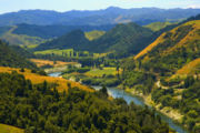
Whanganui River
Encyclopedia

North Island
The North Island is one of the two main islands of New Zealand, separated from the much less populous South Island by Cook Strait. The island is in area, making it the world's 14th-largest island...
of New Zealand
New Zealand
New Zealand is an island country in the south-western Pacific Ocean comprising two main landmasses and numerous smaller islands. The country is situated some east of Australia across the Tasman Sea, and roughly south of the Pacific island nations of New Caledonia, Fiji, and Tonga...
.
Known for many years as the Wanganui River, the river's name reverted to Whanganui in 1991, according with the wishes of local iwi
Iwi
In New Zealand society, iwi form the largest everyday social units in Māori culture. The word iwi means "'peoples' or 'nations'. In "the work of European writers which treat iwi and hapū as parts of a hierarchical structure", it has been used to mean "tribe" , or confederation of tribes,...
. Part of the reason was also to avoid confusion with the Wanganui River
Wanganui River
The Wanganui River is located in the western South Island of New Zealand. It flows northwest for 55 kilometres from its headwaters in the Southern Alps, entering the Tasman Sea near Lake Ianthe, 40 kilometres southwest of Hokitika....
in the South Island
South Island
The South Island is the larger of the two major islands of New Zealand, the other being the more populous North Island. It is bordered to the north by Cook Strait, to the west by the Tasman Sea, to the south and east by the Pacific Ocean...
. The city at the river's mouth was called Wanganui until December 2009, when the government decided that while either spelling was acceptable, Crown agencies would use the Whanganui
Whanganui
Various places in New Zealand are called Whanganui:*Whanganui, a city at the mouth of the Whanganui River, also often spelled "Wanganui", Manawatu-Wanganui Region*Whanganui District, Manawatu-Wanganui Region*Whanganui Island, Waikato Region...
spelling.
Expanse
With a length of 290 km, the Whanganui is the country's third-longest river. Much of the land to either side of the river's upper reaches is part of the Whanganui National ParkWhanganui National Park
The Whanganui National Park is a national park located in the North Island of New Zealand. Established in 1986, it covers an area of 742 km² bordering the Whanganui River. It incorporates areas of Crown land, former state forest and a number of former reserves. The river itself is not part of the...
, though the river itself is not part of the park.
The river rises on the northern slopes of Mount Tongariro
Mount Tongariro
Mount Tongariro is a volcanic complex in the North Island of New Zealand. It is located 20 kilometres to the southwest of Lake Taupo, and is the northernmost of the three active volcanoes that dominate the landscape of the central North Island....
, one of the three active volcano
Volcano
2. Bedrock3. Conduit 4. Base5. Sill6. Dike7. Layers of ash emitted by the volcano8. Flank| 9. Layers of lava emitted by the volcano10. Throat11. Parasitic cone12. Lava flow13. Vent14. Crater15...
es of the central plateau
North Island Volcanic Plateau
The North Island Volcanic Plateau is a volcanic plateau covering much of central North Island of New Zealand with volcanoes, lava plateaus, and crater lakes....
, and close to Lake Rotoaira
Lake Rotoaira
Lake Rotoaira is a small lake to the south of Lake Taupo on the North Island Volcanic Plateau in New Zealand. It covers an area of 13 km²....
. It flows to the north-west before turning south-west at Taumarunui
Taumarunui
Taumarunui is a town in the King Country of the central North Island of New Zealand. It is on State Highway 4 and the North Island Main Trunk Railway....
. From here it runs through the rough, bush-clad hill country of the King Country
King Country
The King Country is a region of the western North Island of New Zealand. It extends approximately from the Kawhia Harbour and the town of Otorohanga in the north to the upper reaches of the Whanganui River in the south, and from the Hauhungaroa and Rangitoto Ranges in the east to near the Tasman...
before turning south-east and flowing past the small settlements of Pipiriki and Jerusalem
Jerusalem, New Zealand
Jerusalem was once an important kainga on the Whanganui River in New Zealand where a Roman Catholic mission was first established in 1854....
, before reaching the coast at Whanganui. It is the country's longest navigable river.
In the 1970s a minor eruption from Mount Ruapehu
Mount Ruapehu
Mount Ruapehu, or just Ruapehu, is an active stratovolcano at the southern end of the Taupo Volcanic Zone in New Zealand. It is 23 kilometres northeast of Ohakune and 40 kilometres southwest of the southern shore of Lake Taupo, within Tongariro National Park...
spilled some of the contents from the Ruapehu Crater Lake (the same root cause of the Tangiwai disaster
Tangiwai disaster
The Tangiwai disaster on 24 December 1953 was the worst rail accident in New Zealand history. An 11-carriage overnight express from Wellington to Auckland fell into the Whangaehu River at Tangiwai, ten kilometres west of Waiouru. The bridge carrying the North Island Main Trunk Railway over the...
). This toxic water entered the Whanganui River and had the effect of killing much of the fish life downstream. In the aftermath of the poisoning eel
Eel
Eels are an order of fish, which consists of four suborders, 20 families, 111 genera and approximately 800 species. Most eels are predators...
s as large as 8.2 kg and trout
Trout
Trout is the name for a number of species of freshwater and saltwater fish belonging to the Salmoninae subfamily of the family Salmonidae. Salmon belong to the same family as trout. Most salmon species spend almost all their lives in salt water...
as large as 2.3 kg were washed up dead along the banks of the river.
The Whanganui River basin contains a variety of flora species, much of which can be characterised as a Broadleaf and Podocarp forest; understory species include Crown Fern, Blechnum discolor
Blechnum discolor
Blechnum discolor is a species of fern in the family Blechnaceae. This species is endemic to New Zealand. As noted by C. Michael Hogan, this species is found in a number of forest communities in diverse locations within New Zealand, and is sometimes a dominant understory component.Spores are...
, and a variety of other ferns and shrubs.
Tributaries
| Tributary Tributary A tributary or affluent is a stream or river that flows into a main stem river or a lake. A tributary does not flow directly into a sea or ocean... Name |
Length (km) | km From Mouth | Confluence Coordinates | Altitude Altitude Altitude or height is defined based on the context in which it is used . As a general definition, altitude is a distance measurement, usually in the vertical or "up" direction, between a reference datum and a point or object. The reference datum also often varies according to the context... |
|---|---|---|---|---|
| Mount Tongariro Mount Tongariro Mount Tongariro is a volcanic complex in the North Island of New Zealand. It is located 20 kilometres to the southwest of Lake Taupo, and is the northernmost of the three active volcanoes that dominate the landscape of the central North Island.... |
River source | 290 km | 39°07.91′S 175°37.95′E | |
| Whakapapa River Whakapapa River The Whakapapa River in New Zealand trickles off the Whakapapa skifield of Mount Ruapehu, down the western slopes of the mountain through Owhango before finally merging with the Whanganui River just east of Kakahi at .... |
38°55.92′S 175°24.50′E | |||
| Kakahi Kakahi Kakahi is a small village about 10 kilometres up the Whanganui River from Taumarunui in New Zealand. It can be accessed from State Highway 4 using access roads Waitea Road or Whakapapa Road.... Stream |
38°55.94′S 175°22.00′E | |||
| Ongarue River Ongarue River The Ongarue River is a river of the Waikato and Manawatu-Wanganui Regions of New Zealand's North Island. A major tributary of the Whanganui River, it flows west then south from its sources in the Hauhungaroa Range northwest of Lake Taupo, passing through the town of Taumarunui before reaching the... |
38°53.54′S 175°15.27′E | |||
| 39°02.34′S 175°03.89′E | ||||
| Retaruke River Retaruke River The Retaruke River is a river on the North Island of New Zealand. It joins with the Whanganui River just above Wade's Landing and downstream from Taumarunui. The river flows through the farming communities of Upper and then Lower Retaruke Valley... |
39°06.65′S 175°03.98′E | |||
| Ohura River Ohura River The Ohura River is a river of the western North Island of New Zealand. It flows southward from its source close to the town of Ohura, and flows into the Whanganui River.... |
||||
| Mangapurua Stream | ||||
| Ruatiti River? | 39°24.30′S 175°2.69′E | |||
| Tangarakau River Tangarakau River The Tangarakau River is a river of the Taranaki and Manawatu-Wanganui Regions of New Zealand's North Island. It flows south from its sources to the northeast of Whangamomona in the King Country to reach the Whanganui River.... |
||||
| Tasman Sea Tasman Sea The Tasman Sea is the large body of water between Australia and New Zealand, approximately across. It extends 2,800 km from north to south. It is a south-western segment of the South Pacific Ocean. The sea was named after the Dutch explorer Abel Janszoon Tasman, the first recorded European... |
River Mouth Base level The base level of a river or stream is the lowest point to which it can flow, often referred to as the 'mouth' of the river. For large rivers, sea level is usually the base level, but a large river or lake is likewise the base level for tributary streams... |
0 km | 39°56.89′S 174°59.22′E | 0 m |
History
Mount Taranaki legend
In Māori legend, Taranaki is a mountain being that lived peacefully for many centuries in the centre of New Zealand's North Island with three other mountains, Tongariro, Ngauruhoe and Ruapehu.Nearby stood Mount Pihanga...
. When Mount Taranaki left the central plateau for the coast, the land was split open, and the river filled the rift. According to Māori tradition, the river was first explored by Tamatea, one of the leaders of the original migration to the new land, who travelled up the river and on to Lake Taupo
Lake Taupo
Lake Taupo is a lake situated in the North Island of New Zealand. With a surface area of , it is the largest lake by surface area in New Zealand, and the second largest freshwater lake by surface area in geopolitical Oceania after Lake Murray ....
. Many places along the river are named in his honour.
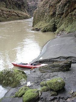
The Whanganui river has always been an important communication route to the central North Island, both for Māori and for settlers. It is, however, also a difficult river, with many stretches of white water and over 200 rapids. Despite this for many years it was the principal route to the interior.
Prior to the arrival of Europeans, the area around the Whanganui was one of the most densely inhabited in the land. Unsurprisingly, with the arrival of the colonial settlers, the area near the river's mouth became a major trading post.
Although it was already a significant route to the interior, the major development of the river as a trade route was by Alexander Hatrick, who started the first regular steam-boat service in 1892. The service eventually ran to Taumarunui
Taumarunui
Taumarunui is a town in the King Country of the central North Island of New Zealand. It is on State Highway 4 and the North Island Main Trunk Railway....
where rail and coach services connected with points north. Riverboats at the Pipiriki Landing One of Hatrick’s original boats, paddle-steamer PS Waimarie
PS Waimarie
The PS Waimarie is an historic riverboat based on the Whanganui River in New Zealand.-History:It is a paddle steamer, built by Yarrow & Co in London in 1899 as a kitset...
, has been restored and runs scheduled sailings in Whanganui. Another of the Hatrick boats, MV Wairua has also been restored and can be seen on the river.
During the early 20th century, the Wanganui River, as it was then called, was one of the country’s top tourist attractions, its rugged beauty and the Māori kainga (villages) which dotted the banks attracting thousands of tourists per year.
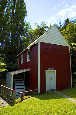
With the completion of the North Island Main Trunk railway, the need for the steamboat route to the north greatly diminished, and the main economic activity of the river area became forestry
Forestry
Forestry is the interdisciplinary profession embracing the science, art, and craft of creating, managing, using, and conserving forests and associated resources in a sustainable manner to meet desired goals, needs, and values for human benefit. Forestry is practiced in plantations and natural stands...
. During the 1930s, attempts were made to open the river valley up as farmland, but they were not successful. One legacy of that time is the Bridge to Nowhere, built to provide access to settlements long since abandoned.
The settlement of Jerusalem is of particular note. Jerusalem was home to two famous New Zealanders, Mother Mary Joseph Aubert, whose Catholic mission is still located at Jerusalem, and New Zealand poet James K. Baxter
James K. Baxter
James Keir Baxter was a poet, and is a celebrated figure in New Zealand society.-Biography:Baxter was born in Dunedin to Archibald Baxter and Millicent Brown and grew up near Brighton. He was named after James Keir Hardie, a founder of the British Labour Party. His father had been a conscientious...
, who established a commune at the settlement in 1970.
River Boat Landings
Ohura River
The Ohura River is a river of the western North Island of New Zealand. It flows southward from its source close to the town of Ohura, and flows into the Whanganui River....
and Ongarue River
Ongarue River
The Ongarue River is a river of the Waikato and Manawatu-Wanganui Regions of New Zealand's North Island. A major tributary of the Whanganui River, it flows west then south from its sources in the Hauhungaroa Range northwest of Lake Taupo, passing through the town of Taumarunui before reaching the...
s unless these routes were log jammed after floods.
Historically - between 1891 to 1958 - the Alexander Hatrick Riverboat
Riverboat
A riverboat is a ship built boat designed for inland navigation on lakes, rivers, and artificial waterways. They are generally equipped and outfitted as work boats in one of the carrying trades, for freight or people transport, including luxury units constructed for entertainment enterprises, such...
service operated on the Whanganui River. The paddle-steamer Wairere ordered from London and shipped in sections then assembled in Whanganui in late 1891.
It is said that Taumarunui
Taumarunui
Taumarunui is a town in the King Country of the central North Island of New Zealand. It is on State Highway 4 and the North Island Main Trunk Railway....
was the highest reach of the Whanganui River that was navigable by river boat. The river flow was managed by the "Wanganui River Trust Board" which built containing walls to direct and deepen the rivers channels for river traffic. Even so, river boats sometimes found it necessary to winch themselves up the more difficult rapids.
| Landing Name | Community Serviced | Distance from Mouth | Travel Time Up/Down | Coordinates |
|---|---|---|---|---|
| Taumarunui Landing | Taumarunui Taumarunui Taumarunui is a town in the King Country of the central North Island of New Zealand. It is on State Highway 4 and the North Island Main Trunk Railway.... |
|||
| Kirikau Landing | Kirikau | |||
| Te Maire Landing | Te Maire | |||
| Otumangu Landing | Otumangu | |||
| Lacy's Landing | ||||
| Wades Landing | Retaruke Valley Retaruke River The Retaruke River is a river on the North Island of New Zealand. It joins with the Whanganui River just above Wade's Landing and downstream from Taumarunui. The river flows through the farming communities of Upper and then Lower Retaruke Valley... |
39°6.65′S 175°3.98′E | ||
| Maungaparua Landing | Maungaparua Valley | |||
| Tangahoe Landing | Tangahoe | |||
| Mangatiti Landing | Mangatiti | |||
| Parinui Landing | Parinui | |||
| Ramanui Landing | Ramanui | |||
| Pipiriki landing | Pipiriki | |||
| Lower Pipiriki landing | Pipiriki | |||
| Hipango Park Landing | ? | |||
| Up-river Landing | ||||
| Wanganui Wharves | Whanganui Whanganui Various places in New Zealand are called Whanganui:*Whanganui, a city at the mouth of the Whanganui River, also often spelled "Wanganui", Manawatu-Wanganui Region*Whanganui District, Manawatu-Wanganui Region*Whanganui Island, Waikato Region... |
Taonga and Māori land claims
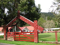
The river is of special and spiritual importance for Māori, who also refer to it as Te awa tupua - it was the home for a large proportion of Māori villages in pre-European times. As such, it is regarded as taongaTaonga
A taonga in Māori culture is a treasured thing, whether tangible or intangible. Tangible examples are all sorts of heirlooms and artefacts, land, fisheries, natural resources such as geothermal springs and access to natural resources, such as riparian water rights and access to the riparian zone of...
, a special treasure. In recent times, efforts have been made to safeguard the river and give it the respect it deserves.
For the same reason, the river has been one of the most fiercely contested regions of the country in claims before the Waitangi Tribunal
Waitangi Tribunal
The Waitangi Tribunal is a New Zealand permanent commission of inquiry established under the Treaty of Waitangi Act 1975...
for the return of tribal lands. In fact the Whanganui River claim is heralded as the longest-running legal case in New Zealand history with petitions and court action in the 1930s, Waitangi Tribunal hearings in the 1990s and land occupations such as the ongoing Tieke Marae occuption since 1993 and the highly publicised Moutoa Gardens
Moutoa Gardens
Moutoa Gardens, also known as Pakaitore, is a park in the city of Wanganui, New Zealand. Named after the Battle of Moutua Island in the Second Taranaki War, it contains a memorial to the battle inscribed "To the memory of the brave men who fell at Moutoa, 14 May 1864, in defence of law and order...
occupation in 1995.
Recreation
- Whanganui National ParkWhanganui National ParkThe Whanganui National Park is a national park located in the North Island of New Zealand. Established in 1986, it covers an area of 742 km² bordering the Whanganui River. It incorporates areas of Crown land, former state forest and a number of former reserves. The river itself is not part of the...
- The Whanganui JourneyWhanganui JourneyThe Whanganui Journey is a river journey along the Whanganui River in the North Island of New Zealand travelling by canoe or kayak. The route, starting at Taumarunui and finishing at Pipiriki, is 145 km long and usually takes 5 days to complete...
is managed by the Department of ConservationNew Zealand Department of ConservationThe Department of Conservation , commonly known by its acronym, "DOC", is the state sector organisation which deals with the conservation of New Zealand’s natural and historic heritage...
under its Great WalksNew Zealand Great WalksThe New Zealand Great Walks are a set of popular tramping tracks. They are New Zealand's premier tracks, through areas of some of the best scenery in the country...
programme. - Hiking (north/south and east/west trails cross on the Whanganui River)
- Te Araroa TrailTe Araroa TrailTe Araroa is New Zealand's newest long distance tramping route, from Cape Reinga to Bluff. It is being built by the Te Araroa Trust and is opening on 3 December 2011....
http://www.teararoa.org.nz/trail_stories.php?story_id=34 - The hiking trail the length of New Zealand and the Whanganui. - East Cape to Cape Egmont TraverseEast Cape to Cape Egmont TraverseThis East Cape to Cape Egmont Traverse is not so much a trail, more a Kiwi pilgrimage to our early pioneers and landscape.Two authors/walkers have completed this traverse and written books:...
East Cape to Cape Egmont - 80 day traverse of the North Island, 1997, Author: Salisbury, Raymond, Publisher: Word for Word Publishing - Matemateaonga Tramping Trail (and others)
- Te Araroa Trail
- Canoeing - lots of historic aspects and sites to visit.
- Annual Raft Race, Piriaka to Taumarunui - Last run in the 1970s
- Annual Jet Boat Race, Taumarunui to Wangaunui - Last run in the 1980s
Bridges
Despite being NZ's longest navigable river, the Whanganui has surprisingly few road bridges. Only two are located on the 230 km stretch between Whanganui and Taumarunui.- Taumarunui (x4) (including Victory Bridge)
- SH 47 Bridge near Tongariro National ParkTongariro National ParkTongariro National Park is the oldest national park in New Zealand, located in the central North Island. It has been acknowledged by UNESCO as one of the 28 mixed cultural and natural World Heritage Sites....
- New Te Maire Bridge (1954)
- Jerusalem, derelict swing bridge.
- Whanganui (x3 - Dublin Street Bridge, City Bridge & Cobham Bridge)
A bridge over the Whanganui to connect Raetihi
Raetihi
Raetihi is a town in the central North Island of New Zealand. It is located at the junction of State Highways 4 and 49, 11 kilometres west of Ohakune. The 2006 New Zealand Census of Population and Dwellings recorded its population as 1,035. This constitutes a decrease of 3.4% or 36 people since...
to Taranaki was to be constructed in the Mangaparua area (where the Bridge to Nowhere
Bridge to Nowhere (New Zealand)
The Bridge to Nowhere is a concrete road bridge spanning the Mangapurua Stream in Whanganui National Park, North Island, New Zealand. It has no roads leading to it, but it is a popular tourist attraction, accessible by boat or kayak, followed by a 45 minute walk along maintained bush trails.It...
is located, but never proceeded
River Boat
In 1892 Alexander Hatrick was contracted by Thomas CookThomas Cook
Thomas Cook of Melbourne, Derbyshire, England founded the travel agency that is now Thomas Cook Group.- Early days :...
to carry tourists to Pipiriki on the paddle-steamer PS Waimarie
PS Waimarie
The PS Waimarie is an historic riverboat based on the Whanganui River in New Zealand.-History:It is a paddle steamer, built by Yarrow & Co in London in 1899 as a kitset...
, the journey was "The Rhine of Maoriland" tourist route into the interior of New Zealand. The river boat subsequently carried mail, passengers and cargo.
Until recently PS Waimarie operated on the lower stretches of the river, including dinner cruises to Avoca Hotel at Upokongaro and trips to Hipango Park for overnight camping.
On 18 June 2010 the Adventurer 2 river boat embarked, attempting to make the 230 kilometre voyage to Taumarunui
Taumarunui
Taumarunui is a town in the King Country of the central North Island of New Zealand. It is on State Highway 4 and the North Island Main Trunk Railway....
. The first voyage to Taumarunui in 82 years. The Adventurer 2 now offers this trip to tourist as an historic alternative to jet boating and canoeing the river. Though in low water flows it can't make it all the way to Taumarunui.