
Milbanke Sound Group
Encyclopedia
The Milbanke Sound Group, also called the Milbanke Sound Cones, is an enigmatic group of five small basalt
ic volcanoes in the Kitimat Ranges
of the Coast Mountains
in British Columbia
, Canada
. Named for Milbanke Sound
, this volcanic group
straddles on at least four small uninhabited islands, including Swindle
, Price, Lady Douglas
and Lake Island
. Not much is known about this group of volcanoes and they remain undated. However, they all likely formed in the past 10,000 years after the last glacial period as evidenced by a small amount of erosion. The age of the most recent volcanic activity is also unknown. Most of the Milbanke Sound Cones are covered by mature forest
. Kitasu Hill
and Helmet Peak are the only two cones that are officially named.
This group of volcanoes is unlike many other volcanic groups in Canada as it resides on islands instead of on the mainland
. The volcanoes form a northwest-southeast trend along the British Columbia Coast
. To the west the Milbanke Sound Group is bounded by the Pacific Ocean
and elsewhere it is surrounded by adjacent islands that form an archipelago
. Although not related, the Milbanke Sound Group is close to the remains of a much older magmatic feature that was formed during the Tertiary
period.
of 230 m (754.6 ft). This is a small symmetrical monogenetic
cinder cone
and the best preserved volcano associated with the Milbanke Sound Group. It is the northernmost and most prominent volcano of the Milbanke Sound Cones with a circular volcanic crater
at its summit. The volcano produced basaltic lava flows that extend to the north. Subaerial tephra
and volcanic bomb
s are the main volcanics comprising the volcano. These volcanics surround eroded remains of the basalt lava flows and are composed of the mineral olivine
. Kitasu Hill rests on till that overlies glacially scoured bedrock.
Near the northeastern shore of Price Island, a small eroded monogenetic cinder cone composed of basalt is covered by mature forest. It has an elevation of 40 m (131.2 ft) and is the source of a basaltic lava flow. This lava flow extends down to the northeastern shoreline of Price Island where it covers beach gravel.
Helmet Peak on the northern end of Lake Island just off the southwestern side of the Don Peninsula
is a steep-sided monogenetic cinder cone. It is composed of welded volcanic blocks and basaltic feeder dikes
. With an elevation of 335 m (1,099.1 ft), Helmet Peak is the highest volcano in the Milbanke Sound Group. During its eruption, basaltic tuff
breccia was sent throughout the surrounding landscape that deposited on glaciated granitic rock and unconsolidated beach gravel near the volcano. This basaltic tuff breccia covers parts of Lake Island and nearby Lady Douglas Island. Blocks of basement granodiorite
, some up to 2 m (6.6 ft) wide, are randomly suspended within the breccia. Basalt on Lake Island is characterized by abundant 0.5 cm (0.196850393700787 in) to 1 cm (0.393700787401575 in) labradorite
and clinopyroxene phenocryst
s.
At the southern end of the Milbanke Sound Group, a small monogenetic cinder cone with an elevation of 50 m (164 ft) resides on Dufferin Island. It sent basaltic lava flows to the north where they reached the island's shoreline to cover beach gravel. Since its formation, the cinder cone has been eroded and covered by forest. Finngal Island, south of Dufferin Island, contains one or more basaltic lava flows that form well-preserved columar jointing. Like other volcanic deposits in the Milbanke Sound Group, little is known about these lava flows.
because they are parallel with its east-west trend. However, this grouping is not widely accepted because the volcanoes are much younger than other magmatic features at the western end of the Anahim Volcanic Belt. The cause of this significant age change is because the Anahim Volcanic Belt has its origins from the North American Plate
moving over the hypothesized Anahim hotspot
. This is a mantle plume
that is likely responsible for volcanism
throughout the Anahim Volcanic Belt. Individual Anahim volcanoes generally become older west of Nazko Cone
, indicating that the North American Plate is moving in a westerly direction with respect to the hotspot
, carrying the volcanoes along with it at a rate of 2 cm (0.78740157480315 in) to 3.3 cm (1.3 in) per year. Thus the hotspot model can not be used to explain the formation of the Milbanke Sound Group. However, the volcanic group is near the remnants of a 14 to 12 million year old magmatic feature that is interpreted to define the westernmost end of the Anahim hotspot track.
A possible explanation for the origin of the Milbanke Sound Group is that it reflects a northern extension of the north-west trending subduction
-related Garibaldi Volcanic Belt
further south. This in turn is a segment of the Cascade Volcanic Arc
in the United States
, which includes Mount Baker
and Mount St. Helens
. However, there is currently not enough data to support this suggestion. Its origins might also result from other tectonic processes that are currently not understood.
has been established to monitor earthquakes, but is too far away to provide a good indication of what is happening beneath the cones. It may sense an increase in activity if a volcano becomes very restless, but this may only provide a warning for a large eruption. It might detect activity only once a volcano has started erupting.
The Interagency Volcanic Event Notification Plan
, Canada's volcanic emergency notification program, was established to outline the notification procedure of some of the main agencies that would be involved in response to a volcanic eruption in Canada, an eruption close to Canada's borders, or an eruption significant enough to have an effect on Canada and its people. It focuses primarily on aviation safety because jet aircraft can quickly enter areas of volcanic ash. The program notifies all impacted agencies that have to deal with volcanic events. Aircraft are rerouted away from hazardous ash and people on the ground are notified of potential ash fall.
Basalt
Basalt is a common extrusive volcanic rock. It is usually grey to black and fine-grained due to rapid cooling of lava at the surface of a planet. It may be porphyritic containing larger crystals in a fine matrix, or vesicular, or frothy scoria. Unweathered basalt is black or grey...
ic volcanoes in the Kitimat Ranges
Kitimat Ranges
The Kitimat Ranges are one of the three main subdivisions of the Coast Mountains in British Columbia, Canada, the other being the Pacific Ranges to the south and the Boundary Ranges to the north...
of the Coast Mountains
Coast Mountains
The Coast Mountains are a major mountain range, in the Pacific Coast Ranges, of western North America, extending from southwestern Yukon through the Alaska Panhandle and virtually all of the Coast of British Columbia. They are so-named because of their proximity to the sea coast, and are often...
in British Columbia
British Columbia
British Columbia is the westernmost of Canada's provinces and is known for its natural beauty, as reflected in its Latin motto, Splendor sine occasu . Its name was chosen by Queen Victoria in 1858...
, Canada
Canada
Canada is a North American country consisting of ten provinces and three territories. Located in the northern part of the continent, it extends from the Atlantic Ocean in the east to the Pacific Ocean in the west, and northward into the Arctic Ocean...
. Named for Milbanke Sound
Milbanke Sound
Milbanke Sound is a sound on the coast of the Canadian province of British Columbia, extending east from Queen Charlotte Sound, with Price Island on the west, Swindle Island on the north, and the Bardswell Group of islands on the south. Milbanke Sound is one of the open sea portions of the Inside...
, this volcanic group
Volcanic group
A volcanic group is a collection of related volcanoes or volcanic landforms. Note that the term is also used in a different sense when it denotes a suite of associated rock strata largely of volcanic origin; see group for details.-Notable volcanic groups:-See also:*Complex...
straddles on at least four small uninhabited islands, including Swindle
Swindle Island
Swindle Island is an island on the North Coast of the Canadian province of British Columbia. It is located south of Princess Royal Island on the Inside Passage shipping route. Price Island lies just south of Swindle Island...
, Price, Lady Douglas
Lady Douglas Island
Lady Douglas Island is an island in the North Coast region of the Canadian province of British Columbia. It is located off the south coast of Dowager Island....
and Lake Island
Lake Island
Lake Island is an island on the coast of the Canadian province of British Columbia. It is located between Mathieson Channel and Lady Trutch Passage....
. Not much is known about this group of volcanoes and they remain undated. However, they all likely formed in the past 10,000 years after the last glacial period as evidenced by a small amount of erosion. The age of the most recent volcanic activity is also unknown. Most of the Milbanke Sound Cones are covered by mature forest
Forest
A forest, also referred to as a wood or the woods, is an area with a high density of trees. As with cities, depending where you are in the world, what is considered a forest may vary significantly in size and have various classification according to how and what of the forest is composed...
. Kitasu Hill
Kitasu Hill
Kitasu Hill is a young basaltic cinder cone on southwestern Swindle Island on the coast of the Canadian province of British Columbia. It is located southwest of Klemtu and south of Kitasu Bay. Kitasu Hill produced lava flows that extend to the north...
and Helmet Peak are the only two cones that are officially named.
This group of volcanoes is unlike many other volcanic groups in Canada as it resides on islands instead of on the mainland
Mainland
Mainland is a name given to a large landmass in a region , or to the largest of a group of islands in an archipelago. Sometimes its residents are called "Mainlanders"...
. The volcanoes form a northwest-southeast trend along the British Columbia Coast
British Columbia Coast
The British Columbia Coast or BC Coast is Canada's western continental coastline on the Pacific Ocean. The usage is synonymous with the term West Coast of Canada....
. To the west the Milbanke Sound Group is bounded by the Pacific Ocean
Pacific Ocean
The Pacific Ocean is the largest of the Earth's oceanic divisions. It extends from the Arctic in the north to the Southern Ocean in the south, bounded by Asia and Australia in the west, and the Americas in the east.At 165.2 million square kilometres in area, this largest division of the World...
and elsewhere it is surrounded by adjacent islands that form an archipelago
Archipelago
An archipelago , sometimes called an island group, is a chain or cluster of islands. The word archipelago is derived from the Greek ἄρχι- – arkhi- and πέλαγος – pélagos through the Italian arcipelago...
. Although not related, the Milbanke Sound Group is close to the remains of a much older magmatic feature that was formed during the Tertiary
Tertiary
The Tertiary is a deprecated term for a geologic period 65 million to 2.6 million years ago. The Tertiary covered the time span between the superseded Secondary period and the Quaternary...
period.
Volcanoes
Just south of Kitasu Bay on the southwestern shore of Swindle Island, Kitasu Hill rises with an elevation of 250 m (820.2 ft) and a topographic prominenceTopographic prominence
In topography, prominence, also known as autonomous height, relative height, shoulder drop , or prime factor , categorizes the height of the mountain's or hill's summit by the elevation between it and the lowest contour line encircling it and no higher summit...
of 230 m (754.6 ft). This is a small symmetrical monogenetic
Monogenetic volcanic field
A monogenetic volcanic field is a volcanic field of small, scattered volcanic vents. These volcanic fields, containing numerous monogenetic volcanoes, are noted for having only one short eruptive event at each volcano, as opposed to regular volcanoes that have several eruptions from the same vent...
cinder cone
Cinder cone
According to the , Cinder Cone is the proper name of 1 cinder cone in Canada and 7 cinder cones in the United States:In Canada: Cinder Cone In the United States:...
and the best preserved volcano associated with the Milbanke Sound Group. It is the northernmost and most prominent volcano of the Milbanke Sound Cones with a circular volcanic crater
Volcanic crater
A volcanic crater is a circular depression in the ground caused by volcanic activity. It is typically a basin, circular in form within which occurs a vent from which magma erupts as gases, lava, and ejecta. A crater can be of large dimensions, and sometimes of great depth...
at its summit. The volcano produced basaltic lava flows that extend to the north. Subaerial tephra
Tephra
200px|thumb|right|Tephra horizons in south-central [[Iceland]]. The thick and light coloured layer at center of the photo is [[rhyolitic]] tephra from [[Hekla]]....
and volcanic bomb
Volcanic bomb
A volcanic bomb is a mass of molten rock larger than 65 mm in diameter, formed when a volcano ejects viscous fragments of lava during an eruption. They cool into solid fragments before they reach the ground. Because volcanic bombs cool after they leave the volcano, they do not have grains...
s are the main volcanics comprising the volcano. These volcanics surround eroded remains of the basalt lava flows and are composed of the mineral olivine
Olivine
The mineral olivine is a magnesium iron silicate with the formula 2SiO4. It is a common mineral in the Earth's subsurface but weathers quickly on the surface....
. Kitasu Hill rests on till that overlies glacially scoured bedrock.
Near the northeastern shore of Price Island, a small eroded monogenetic cinder cone composed of basalt is covered by mature forest. It has an elevation of 40 m (131.2 ft) and is the source of a basaltic lava flow. This lava flow extends down to the northeastern shoreline of Price Island where it covers beach gravel.
Helmet Peak on the northern end of Lake Island just off the southwestern side of the Don Peninsula
Don Peninsula
The Don Peninsula is a peninsula in British Columbia, Canada. It extends southwest between the Mathieson and Spiller Channels in the Milbanke Sound area. Later discovered to be a peninsula, it was first charted as an island....
is a steep-sided monogenetic cinder cone. It is composed of welded volcanic blocks and basaltic feeder dikes
Dike (geology)
A dike or dyke in geology is a type of sheet intrusion referring to any geologic body that cuts discordantly across* planar wall rock structures, such as bedding or foliation...
. With an elevation of 335 m (1,099.1 ft), Helmet Peak is the highest volcano in the Milbanke Sound Group. During its eruption, basaltic tuff
Tuff
Tuff is a type of rock consisting of consolidated volcanic ash ejected from vents during a volcanic eruption. Tuff is sometimes called tufa, particularly when used as construction material, although tufa also refers to a quite different rock. Rock that contains greater than 50% tuff is considered...
breccia was sent throughout the surrounding landscape that deposited on glaciated granitic rock and unconsolidated beach gravel near the volcano. This basaltic tuff breccia covers parts of Lake Island and nearby Lady Douglas Island. Blocks of basement granodiorite
Granodiorite
Granodiorite is an intrusive igneous rock similar to granite, but containing more plagioclase than orthoclase-type feldspar. Officially, it is defined as a phaneritic igneous rock with greater than 20% quartz by volume where at least 65% of the feldspar is plagioclase. It usually contains abundant...
, some up to 2 m (6.6 ft) wide, are randomly suspended within the breccia. Basalt on Lake Island is characterized by abundant 0.5 cm (0.196850393700787 in) to 1 cm (0.393700787401575 in) labradorite
Labradorite
Labradorite , a feldspar mineral, is an intermediate to calcic member of the plagioclase series. It is usually defined as having "%An" between 50 and 70. The specific gravity ranges from 2.68 to 2.72. The streak is white, like most silicates. The refractive index ranges from 1.559 to 1.573....
and clinopyroxene phenocryst
Phenocryst
thumb|right|300px|[[Granite]]s often have large [[feldspar|feldspatic]] phenocrysts. This granite, from the [[Switzerland|Swiss]] side of the [[Mont Blanc]] massif, has large white [[plagioclase]] phenocrysts, [[triclinic]] [[mineral]]s that give [[trapezium|trapezoid]] shapes when cut through)...
s.
At the southern end of the Milbanke Sound Group, a small monogenetic cinder cone with an elevation of 50 m (164 ft) resides on Dufferin Island. It sent basaltic lava flows to the north where they reached the island's shoreline to cover beach gravel. Since its formation, the cinder cone has been eroded and covered by forest. Finngal Island, south of Dufferin Island, contains one or more basaltic lava flows that form well-preserved columar jointing. Like other volcanic deposits in the Milbanke Sound Group, little is known about these lava flows.
Origins
The relationship of the Milbanke Sound Cones and to other volcanoes throughout British Columbia is not clear. In some classifications, they are grouped with the Anahim Volcanic BeltAnahim Volcanic Belt
The Anahim Volcanic Belt is a long volcanic belt, stretching from just north of Vancouver Island to near Quesnel, British Columbia, Canada. The Anahim Volcanic Belt has had three main magmatic episodes: 15–13 Ma, 9–6 Ma, and 3–1 Ma. The volcanoes generally become younger eastward at a rate of to ...
because they are parallel with its east-west trend. However, this grouping is not widely accepted because the volcanoes are much younger than other magmatic features at the western end of the Anahim Volcanic Belt. The cause of this significant age change is because the Anahim Volcanic Belt has its origins from the North American Plate
North American Plate
The North American Plate is a tectonic plate covering most of North America, Greenland, Cuba, Bahamas, and parts of Siberia, Japan and Iceland. It extends eastward to the Mid-Atlantic Ridge and westward to the Chersky Range in eastern Siberia. The plate includes both continental and oceanic crust...
moving over the hypothesized Anahim hotspot
Anahim hotspot
The Anahim hotspot is a volcanic hotspot in central British Columbia, Canada. It is situated on the Interior Plateau, a large region that lies between the Cariboo and Monashee Mountains to the east, and the Hazelton Mountains, Coast Mountains and Cascade Range to the west...
. This is a mantle plume
Mantle plume
A mantle plume is a hypothetical thermal diapir of abnormally hot rock that nucleates at the core-mantle boundary and rises through the Earth's mantle. Such plumes were invoked in 1971 to explain volcanic regions that were not thought to be explicable by the then-new theory of plate tectonics. Some...
that is likely responsible for volcanism
Volcanism
Volcanism is the phenomenon connected with volcanoes and volcanic activity. It includes all phenomena resulting from and causing magma within the crust or mantle of a planet to rise through the crust and form volcanic rocks on the surface....
throughout the Anahim Volcanic Belt. Individual Anahim volcanoes generally become older west of Nazko Cone
Nazko Cone
Nazko Cone is a small potentially active basaltic cinder cone in central British Columbia, Canada, located 75 km west of Quesnel and 150 kilometers southwest of Prince George. It is considered the easternmost volcano in the Anahim Volcanic Belt. The small tree-covered cone rises 120 m above...
, indicating that the North American Plate is moving in a westerly direction with respect to the hotspot
Hotspot (geology)
The places known as hotspots or hot spots in geology are volcanic regions thought to be fed by underlying mantle that is anomalously hot compared with the mantle elsewhere. They may be on, near to, or far from tectonic plate boundaries. There are two hypotheses to explain them...
, carrying the volcanoes along with it at a rate of 2 cm (0.78740157480315 in) to 3.3 cm (1.3 in) per year. Thus the hotspot model can not be used to explain the formation of the Milbanke Sound Group. However, the volcanic group is near the remnants of a 14 to 12 million year old magmatic feature that is interpreted to define the westernmost end of the Anahim hotspot track.
A possible explanation for the origin of the Milbanke Sound Group is that it reflects a northern extension of the north-west trending subduction
Subduction
In geology, subduction is the process that takes place at convergent boundaries by which one tectonic plate moves under another tectonic plate, sinking into the Earth's mantle, as the plates converge. These 3D regions of mantle downwellings are known as "Subduction Zones"...
-related Garibaldi Volcanic Belt
Garibaldi Volcanic Belt
The Garibaldi Volcanic Belt, also called the Canadian Cascade Arc, is a northwest-southeast trending volcanic chain in the Pacific Ranges of the Coast Mountains that extends from Watts Point in the south to the Ha-Iltzuk Icefield in the north. This chain of volcanoes is located in southwestern...
further south. This in turn is a segment of the Cascade Volcanic Arc
Cascade Volcanoes
The Cascade Volcanoes are a number of volcanoes in a volcanic arc in western North America, extending from southwestern British Columbia through Washington and Oregon to Northern California, a distance of well over 700 mi ...
in the United States
United States
The United States of America is a federal constitutional republic comprising fifty states and a federal district...
, which includes Mount Baker
Mount Baker
Mount Baker , also known as Koma Kulshan or simply Kulshan, is an active glaciated andesitic stratovolcano in the Cascade Volcanic Arc and the North Cascades of Washington State in the United States. It is the second-most active volcano in the range after Mount Saint Helens...
and Mount St. Helens
Mount St. Helens
Mount St. Helens is an active stratovolcano located in Skamania County, Washington, in the Pacific Northwest region of the United States. It is south of Seattle, Washington and northeast of Portland, Oregon. Mount St. Helens takes its English name from the British diplomat Lord St Helens, a...
. However, there is currently not enough data to support this suggestion. Its origins might also result from other tectonic processes that are currently not understood.
Monitoring
Currently, the Milbanke Sound Cones are not monitored closely enough by the Geological Survey of Canada to ascertain how active their magma chambers are. An existing netwok of seismographsSeismometer
Seismometers are instruments that measure motions of the ground, including those of seismic waves generated by earthquakes, volcanic eruptions, and other seismic sources...
has been established to monitor earthquakes, but is too far away to provide a good indication of what is happening beneath the cones. It may sense an increase in activity if a volcano becomes very restless, but this may only provide a warning for a large eruption. It might detect activity only once a volcano has started erupting.
The Interagency Volcanic Event Notification Plan
Interagency Volcanic Event Notification Plan
The Interagency Volcanic Event Notification Plan is a program in Canada established to outline the notification procedure of some of the main agencies that would be involved in response to a volcanic eruption in Canada, an eruption close to Canada's borders, or significant enough that a volcanic...
, Canada's volcanic emergency notification program, was established to outline the notification procedure of some of the main agencies that would be involved in response to a volcanic eruption in Canada, an eruption close to Canada's borders, or an eruption significant enough to have an effect on Canada and its people. It focuses primarily on aviation safety because jet aircraft can quickly enter areas of volcanic ash. The program notifies all impacted agencies that have to deal with volcanic events. Aircraft are rerouted away from hazardous ash and people on the ground are notified of potential ash fall.
See also
- List of volcanoes in Canada
- Volcanism of Canada
- Volcanism of Western CanadaVolcanism of Western CanadaVolcanism of Western Canada produces lava flows, lava plateaus, lava domes, cinder cones, stratovolcanoes, shield volcanoes, submarine volcanoes, calderas, diatremes and maars, along with examples of more less common volcanic forms such as tuyas and subglacial mounds.-Volcanic belts:*Anahim...
- Volcanism of Northern CanadaVolcanism of Northern CanadaVolcanism of Northern Canada has led to the formation of hundreds of volcanic areas and extensive lava formations across Northern Canada, indicating volcanism played a major role in shaping its surface...
- Volcanism of Eastern CanadaVolcanism of Eastern CanadaVolcanism of Eastern Canada has led to the formation of hundreds of volcanic areas and extensive lava formations, indicating volcanism played a major role in shaping its surface. The region's different volcano and lava types originate from different tectonic settings and types of volcanic...
External links
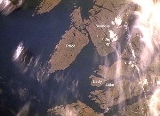
- Satellite images of the Milbanke Sound Group
- Map of the Anahim Volcanic Belt (includes the Milbanke Sound Group volcanoes)