

Meteorological instrumentation
Encyclopedia
Meteorology
Meteorology is the interdisciplinary scientific study of the atmosphere. Studies in the field stretch back millennia, though significant progress in meteorology did not occur until the 18th century. The 19th century saw breakthroughs occur after observing networks developed across several countries...
is a science which does not use much lab equipment but relies more on field-mode observation equipment. In science, an observation, or observable, is an abstract idea that can be measured and for which data can be taken. Rain was one of the first quantities to be measured historically. Two other accurately measured weather
Weather
Weather is the state of the atmosphere, to the degree that it is hot or cold, wet or dry, calm or stormy, clear or cloudy. Most weather phenomena occur in the troposphere, just below the stratosphere. Weather refers, generally, to day-to-day temperature and precipitation activity, whereas climate...
-related variables are wind and humidity. Many attempts had been made prior to the 15th century to construct adequate equipment to measure atmospheric variables.
The devices to measure these three sprang up in the mid-15th century and were respectively the rain gauge
Rain gauge
A rain gauge is a type of instrument used by meteorologists and hydrologists to gather and measure the amount of liquid precipitation over a set period of time....
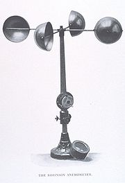
, the anemometer
Anemometer
An anemometer is a device for measuring wind speed, and is a common weather station instrument. The term is derived from the Greek word anemos, meaning wind, and is used to describe any airspeed measurement instrument used in meteorology or aerodynamics...
, and the hygrometer
Hygrometer
A hygrometer is an instrument used for measuring the moisture content in the environmental air, or humidity. Most measurement devices usually rely on measurements of some other quantity such as temperature, pressure, mass or a mechanical or electrical change in a substance as moisture is absorbed...
. The 17th century saw the development of the barometer
Barometer
A barometer is a scientific instrument used in meteorology to measure atmospheric pressure. Pressure tendency can forecast short term changes in the weather...
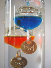
and the Galileo thermometer
Galileo thermometer
A Galileo thermometer , named after Italian physicist Galileo Galilei, is a thermometer made of a sealed glass cylinder containing a clear liquid and a series of objects whose densities are such that they rise or fall as the temperature changes...
, while the 18th century saw the development of the thermometer
Thermometer
Developed during the 16th and 17th centuries, a thermometer is a device that measures temperature or temperature gradient using a variety of different principles. A thermometer has two important elements: the temperature sensor Developed during the 16th and 17th centuries, a thermometer (from the...
with the Fahrenheit
Fahrenheit
Fahrenheit is the temperature scale proposed in 1724 by, and named after, the German physicist Daniel Gabriel Fahrenheit . Within this scale, the freezing of water into ice is defined at 32 degrees, while the boiling point of water is defined to be 212 degrees...
and Celsius
Celsius
Celsius is a scale and unit of measurement for temperature. It is named after the Swedish astronomer Anders Celsius , who developed a similar temperature scale two years before his death...
scales. The 20th century developed new remote sensing
Remote sensing
Remote sensing is the acquisition of information about an object or phenomenon, without making physical contact with the object. In modern usage, the term generally refers to the use of aerial sensor technologies to detect and classify objects on Earth by means of propagated signals Remote sensing...
tools, such as weather radar
Weather radar
Weather radar, also called weather surveillance radar and Doppler weather radar, is a type of radar used to locate precipitation, calculate its motion, estimate its type . Modern weather radars are mostly pulse-Doppler radars, capable of detecting the motion of rain droplets in addition to the...
s and weather satellite
Weather satellite
The weather satellite is a type of satellite that is primarily used to monitor the weather and climate of the Earth. Satellites can be either polar orbiting, seeing the same swath of the Earth every 12 hours, or geostationary, hovering over the same spot on Earth by orbiting over the equator while...
s, which provide better sampling both regionally and globally. Remote sensing instruments collect data from remote weather events and subsequently producing weather information. Each remote sensing instruments collects data about the atmosphere from a remote location and, usually, stores the data where the instrument is located.
History of measurement and scales
Sejong the Great of Joseon
Sejong the Great was the fourth king of the Joseon Dynasty of Korea. During his regency, he reinforced Korean Confucian policies and executed major legal amendments . He also used the creation of Hangul and the advancement of technology to expand his territory...
's son, Prince Munjong, invented the first standardized rain gauge
Rain gauge
A rain gauge is a type of instrument used by meteorologists and hydrologists to gather and measure the amount of liquid precipitation over a set period of time....
. These were sent throughout the Joseon Dynasty
Joseon Dynasty
Joseon , was a Korean state founded by Taejo Yi Seong-gye that lasted for approximately five centuries. It was founded in the aftermath of the overthrow of the Goryeo at what is today the city of Kaesong. Early on, Korea was retitled and the capital was relocated to modern-day Seoul...
of Korea as an official tool to assess land taxes based upon a farmer's potential harvest. In 1450, Leone Battista Alberti
Leone Battista Alberti
Leon Battista Alberti was an Italian author, artist, architect, poet, priest, linguist, philosopher, cryptographer and general Renaissance humanist polymath...
developed a swinging-plate anemometer
Anemometer
An anemometer is a device for measuring wind speed, and is a common weather station instrument. The term is derived from the Greek word anemos, meaning wind, and is used to describe any airspeed measurement instrument used in meteorology or aerodynamics...
, and is known as the first anemometer. In 1607, Galileo Galilei
Galileo Galilei
Galileo Galilei , was an Italian physicist, mathematician, astronomer, and philosopher who played a major role in the Scientific Revolution. His achievements include improvements to the telescope and consequent astronomical observations and support for Copernicanism...
constructs a thermoscope
Galileo thermometer
A Galileo thermometer , named after Italian physicist Galileo Galilei, is a thermometer made of a sealed glass cylinder containing a clear liquid and a series of objects whose densities are such that they rise or fall as the temperature changes...
. In 1643, Evangelista Torricelli
Evangelista Torricelli
Evangelista Torricelli was an Italian physicist and mathematician, best known for his invention of the barometer.-Biography:Evangelista Torricelli was born in Faenza, part of the Papal States...
invents the mercury barometer
Barometer
A barometer is a scientific instrument used in meteorology to measure atmospheric pressure. Pressure tendency can forecast short term changes in the weather...
. In 1662, Sir Christopher Wren
Christopher Wren
Sir Christopher Wren FRS is one of the most highly acclaimed English architects in history.He used to be accorded responsibility for rebuilding 51 churches in the City of London after the Great Fire in 1666, including his masterpiece, St. Paul's Cathedral, on Ludgate Hill, completed in 1710...
invented the mechanical, self-emptying, tipping bucket rain gauge. In 1714, Gabriel Fahrenheit
Gabriel Fahrenheit
Daniel Gabriel Fahrenheit was a German physicist, engineer, and glass blower who is best known for inventing the alcohol thermometer and the mercury thermometer , and for developing a temperature scale now named after him.- Biography :Fahrenheit was born in 1686 in Danzig , the Polish-Lithuanian...
creates a reliable scale for measuring temperature with a mercury-type thermometer. In 1742, Anders Celsius
Anders Celsius
Anders Celsius was a Swedish astronomer. He was professor of astronomy at Uppsala University from 1730 to 1744, but traveled from 1732 to 1735 visiting notable observatories in Germany, Italy and France. He founded the Uppsala Astronomical Observatory in 1741, and in 1742 he proposed the Celsius...
, a Swedish astronomer, proposed the 'centigrade' temperature scale, the predecessor of the current Celsius
Celsius
Celsius is a scale and unit of measurement for temperature. It is named after the Swedish astronomer Anders Celsius , who developed a similar temperature scale two years before his death...
scale. In 1783, the first hair hygrometer
Hygrometer
A hygrometer is an instrument used for measuring the moisture content in the environmental air, or humidity. Most measurement devices usually rely on measurements of some other quantity such as temperature, pressure, mass or a mechanical or electrical change in a substance as moisture is absorbed...
is demonstrated by Horace-Bénédict de Saussure
Horace-Bénédict de Saussure
200px|thumb|Portrait of Horace-Bénédict de Saussure Horace-Bénédict de Saussure was a Genevan aristocrat, physicist and Alpine traveller, often considered the founder of alpinism, and considered to be the first person to build a successful solar oven.-Life and work:Saussure was born in Conches,...
. In 1806, Francis Beaufort
Francis Beaufort
Rear-Admiral Sir Francis Beaufort, FRS, FRGS was an Irish hydrographer and officer in Britain's Royal Navy...
introduced his system for classifying wind speeds
Beaufort scale
The Beaufort Scale is an empirical measure that relates wind speed to observed conditions at sea or on land. Its full name is the Beaufort Wind Force Scale.-History:...
. The April 1960 launch of the first successful weather satellite
Weather satellite
The weather satellite is a type of satellite that is primarily used to monitor the weather and climate of the Earth. Satellites can be either polar orbiting, seeing the same swath of the Earth every 12 hours, or geostationary, hovering over the same spot on Earth by orbiting over the equator while...
, TIROS-1
TIROS-1
TIROS I was the first successful weather satellite, and the first of a series of Television Infrared Observation Satellites...
, marked the beginning of the age where weather information became available globally.
Types

A thermometer measures air temperature
Temperature
Temperature is a physical property of matter that quantitatively expresses the common notions of hot and cold. Objects of low temperature are cold, while various degrees of higher temperatures are referred to as warm or hot...
, or the kinetic energy of the molecules within air. A barometer measures atmospheric pressure
Atmospheric pressure
Atmospheric pressure is the force per unit area exerted into a surface by the weight of air above that surface in the atmosphere of Earth . In most circumstances atmospheric pressure is closely approximated by the hydrostatic pressure caused by the weight of air above the measurement point...
, or the pressure exerted by the weight of the Earth's atmosphere
Earth's atmosphere
The atmosphere of Earth is a layer of gases surrounding the planet Earth that is retained by Earth's gravity. The atmosphere protects life on Earth by absorbing ultraviolet solar radiation, warming the surface through heat retention , and reducing temperature extremes between day and night...
above a particular location. An anemometer
Anemometer
An anemometer is a device for measuring wind speed, and is a common weather station instrument. The term is derived from the Greek word anemos, meaning wind, and is used to describe any airspeed measurement instrument used in meteorology or aerodynamics...
measures the wind
Wind
Wind is the flow of gases on a large scale. On Earth, wind consists of the bulk movement of air. In outer space, solar wind is the movement of gases or charged particles from the sun through space, while planetary wind is the outgassing of light chemical elements from a planet's atmosphere into space...
speed and the direction the wind is blowing from at the site where it is mounted. A hygrometer measures the relative humidity
Relative humidity
Relative humidity is a term used to describe the amount of water vapor in a mixture of air and water vapor. It is defined as the partial pressure of water vapor in the air-water mixture, given as a percentage of the saturated vapor pressure under those conditions...
at a location, which can then be used to compute the dew point
Dew point
The dew point is the temperature to which a given parcel of humid air must be cooled, at constant barometric pressure, for water vapor to condense into liquid water. The condensed water is called dew when it forms on a solid surface. The dew point is a saturation temperature.The dew point is...
. Radiosondes directly measure most of these quantities, except for wind, which is determined by tracking the radiosonde signal with an antenna or theodolite
Theodolite
A theodolite is a precision instrument for measuring angles in the horizontal and vertical planes. Theodolites are mainly used for surveying applications, and have been adapted for specialized purposes in fields like metrology and rocket launch technology...
. Supplementing the radiosondes a network of aircraft collection is organized by the World Meteorological Organization
World Meteorological Organization
The World Meteorological Organization is an intergovernmental organization with a membership of 189 Member States and Territories. It originated from the International Meteorological Organization , which was founded in 1873...
, which also use these instruments to report weather conditions at their respective locations. A sounding rocket
Sounding rocket
A sounding rocket, sometimes called a research rocket, is an instrument-carrying rocket designed to take measurements and perform scientific experiments during its sub-orbital flight. The origin of the term comes from nautical vocabulary, where to sound is to throw a weighted line from a ship into...
, sometimes called a research rocket, is an instrument-carrying rocket designed to take measurements and perform scientific experiments during its sub-orbital flight.
A pyranometer
Pyranometer
A pyranometer is a type of actinometer used to measure broadband solar irradiance on a planar surface and is a sensor that is designed to measure the solar radiation flux density from a field of view of 180 degrees...
is a type of actinometer
Actinometer
Actinometers are instruments used to measure the heating power of radiation. They are used in meteorology to measure solar radiation as pyrheliometers.An actinometer is a chemical system or physical device which determines the number of...
used to measure broadband solar irradiance on a planar surface and is a sensor that is designed to measure the solar radiation flux density (in watts per metre square) from a field of view of 180 degrees. A ceilometer
Ceilometer
A ceilometer is a device that uses a laser or other light source to determine the height of a cloud base. Ceilometers can also be used to measure the aerosol concentration within the atmosphere.-Optical Drum Ceilometer:...
is a device that uses a laser or other light source to determine the height of a cloud base. Ceilometers can also be used to measure the aerosol concentration within the atmosphere. A ceiling balloon
Ceiling balloon
A ceiling balloon is used by meteorologists to determine the height of the base of clouds above ground level during daylight hours.The principle behind the ceiling balloon is a balloon with a known ascent rate and determining how long the balloon rises until it disappears into the cloud.Ascent...
is used by meteorologists to determine the height of the base of clouds above ground level during daylight hours. The principle behind the ceiling balloon is a balloon with a known ascent rate (how fast it climbs) and determining how long the balloon rises until it disappears into the cloud. Ascent rate times ascent time yields the ceiling height. A disdrometer
Disdrometer
A disdrometer is an instrument used to measure the drop size distribution and velocity of falling hydrometeors. Some disdrometers can distinguish between rain, graupel, and hail....
is an instrument used to measure the drop size distribution and velocity of falling hydrometeors. Some disdrometers can distinguish between rain, graupel, and hail. Rain gages are used to measure the precipitation
Precipitation (meteorology)
In meteorology, precipitation In meteorology, precipitation In meteorology, precipitation (also known as one of the classes of hydrometeors, which are atmospheric water phenomena is any product of the condensation of atmospheric water vapor that falls under gravity. The main forms of precipitation...
which falls at any point on the Earth's landmass.
Remote sensing
Remote sensing
Remote sensing is the acquisition of information about an object or phenomenon, without making physical contact with the object. In modern usage, the term generally refers to the use of aerial sensor technologies to detect and classify objects on Earth by means of propagated signals Remote sensing...
, as used in meteorology, is the concept of collecting data from remote weather events and subsequently producing weather information. Each remote sensing instruments collects data about the atmosphere from a remote location and, usually, stores the data where the instrument is located. The common types of remote sensing are Radar
Radar
Radar is an object-detection system which uses radio waves to determine the range, altitude, direction, or speed of objects. It can be used to detect aircraft, ships, spacecraft, guided missiles, motor vehicles, weather formations, and terrain. The radar dish or antenna transmits pulses of radio...
, Lidar
LIDAR
LIDAR is an optical remote sensing technology that can measure the distance to, or other properties of a target by illuminating the target with light, often using pulses from a laser...
, and satellites (or photogrammetry
Photogrammetry
Photogrammetry is the practice of determining the geometric properties of objects from photographic images. Photogrammetry is as old as modern photography and can be dated to the mid-nineteenth century....
). The main uses of radar are to collect information concerning the coverage of precipitation and wind. Satellites are chiefly used to determine cloud cover, as well as wind. SODAR
SODAR
SODAR , also written as sodar, is a meteorological instrument used as a wind profiler to measure the scattering of sound waves by atmospheric turbulence...
(SOnic Detection And Ranging) is a meteorological instrument also known as a wind profiler
Wind profiler
A wind profiler is a type of weather observing equipment that uses radar or sound waves to detect the wind speed and direction at various elevations above the ground. Readings are made at each kilometer above sea level, up to the extent of the troposphere...
which measures the scattering of sound waves by atmospheric turbulence. SODAR systems are used to measure wind speed at various heights above the ground, and the thermodynamic structure of the lower layer of the atmosphere. RADAR and LIDAR are not passive because both use EM radiation to illuminate a specific portion of the atmosphere. Weather satellites along with more general-purpose Earth-observing satellites circling the earth at various altitudes have become an indispensable tool for studying a wide range of phenomena from forest fires to El Niño.
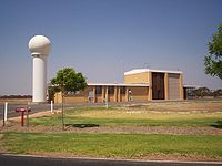
Weather stations
A weather stationWeather station
A weather station is a facility, either on land or sea, with instruments and equipment for observing atmospheric conditions to provide information for weather forecasts and to study the weather and climate. The measurements taken include temperature, barometric pressure, humidity, wind speed, wind...
is a facility with instruments and equipment to make observations of atmospheric
Earth's atmosphere
The atmosphere of Earth is a layer of gases surrounding the planet Earth that is retained by Earth's gravity. The atmosphere protects life on Earth by absorbing ultraviolet solar radiation, warming the surface through heat retention , and reducing temperature extremes between day and night...
conditions in order to provide information to make weather forecasts
Weather forecasting
Weather forecasting is the application of science and technology to predict the state of the atmosphere for a given location. Human beings have attempted to predict the weather informally for millennia, and formally since the nineteenth century...
and to study the weather
Weather
Weather is the state of the atmosphere, to the degree that it is hot or cold, wet or dry, calm or stormy, clear or cloudy. Most weather phenomena occur in the troposphere, just below the stratosphere. Weather refers, generally, to day-to-day temperature and precipitation activity, whereas climate...
and climate
Climate
Climate encompasses the statistics of temperature, humidity, atmospheric pressure, wind, rainfall, atmospheric particle count and other meteorological elemental measurements in a given region over long periods...
. The measurements taken include temperature
Temperature
Temperature is a physical property of matter that quantitatively expresses the common notions of hot and cold. Objects of low temperature are cold, while various degrees of higher temperatures are referred to as warm or hot...
, barometric pressure, humidity
Humidity
Humidity is a term for the amount of water vapor in the air, and can refer to any one of several measurements of humidity. Formally, humid air is not "moist air" but a mixture of water vapor and other constituents of air, and humidity is defined in terms of the water content of this mixture,...
, wind speed
Wind speed
Wind speed, or wind velocity, is a fundamental atmospheric rate.Wind speed affects weather forecasting, aircraft and maritime operations, construction projects, growth and metabolism rate of many plant species, and countless other implications....
, wind direction
Wind direction
Wind direction is reported by the direction from which it originates. For example, a northerly wind blows from the north to the south. Wind direction is usually reported in cardinal directions or in azimuth degrees...
, and precipitation
Precipitation (meteorology)
In meteorology, precipitation In meteorology, precipitation In meteorology, precipitation (also known as one of the classes of hydrometeors, which are atmospheric water phenomena is any product of the condensation of atmospheric water vapor that falls under gravity. The main forms of precipitation...
amounts. Wind measurements are taken as free of other obstructions as possible, while temperature and humidity measurements are kept free from direct solar radiation, or insolation
Insolation
Insolation is a measure of solar radiation energy received on a given surface area in a given time. It is commonly expressed as average irradiance in watts per square meter or kilowatt-hours per square meter per day...
. Manual observations are taken at least once daily, while automated observations are taken at least once an hour.
Surface weather observations
Surface weather observation
Surface weather observations are the fundamental data used for safety as well as climatological reasons to forecast weather and issue warnings worldwide. They can be taken manually, by a weather observer, by computer through the use of automated weather stations, or in a hybrid scheme using...
s are the fundamental data used for safety as well as climatological
Climatology
Climatology is the study of climate, scientifically defined as weather conditions averaged over a period of time, and is a branch of the atmospheric sciences...
reasons to forecast weather
Weather forecasting
Weather forecasting is the application of science and technology to predict the state of the atmosphere for a given location. Human beings have attempted to predict the weather informally for millennia, and formally since the nineteenth century...
and issue warnings worldwide. They can be taken manually, by a weather observer, by computer through the use of automated weather station
Weather station
A weather station is a facility, either on land or sea, with instruments and equipment for observing atmospheric conditions to provide information for weather forecasts and to study the weather and climate. The measurements taken include temperature, barometric pressure, humidity, wind speed, wind...
s, or in a hybrid scheme using weather observers to augment the otherwise automated weather station. The ICAO defines the International Standard Atmosphere
International Standard Atmosphere
The International Standard Atmosphere is an atmospheric model of how the pressure, temperature, density, and viscosity of the Earth's atmosphere change over a wide range of altitudes. It has been established to provide a common reference for temperature and pressure and consists of tables of...
, which is the model of the standard variation of pressure
Pressure
Pressure is the force per unit area applied in a direction perpendicular to the surface of an object. Gauge pressure is the pressure relative to the local atmospheric or ambient pressure.- Definition :...
, temperature
Temperature
Temperature is a physical property of matter that quantitatively expresses the common notions of hot and cold. Objects of low temperature are cold, while various degrees of higher temperatures are referred to as warm or hot...
, density
Density
The mass density or density of a material is defined as its mass per unit volume. The symbol most often used for density is ρ . In some cases , density is also defined as its weight per unit volume; although, this quantity is more properly called specific weight...
, and viscosity
Viscosity
Viscosity is a measure of the resistance of a fluid which is being deformed by either shear or tensile stress. In everyday terms , viscosity is "thickness" or "internal friction". Thus, water is "thin", having a lower viscosity, while honey is "thick", having a higher viscosity...
with altitude
Altitude
Altitude or height is defined based on the context in which it is used . As a general definition, altitude is a distance measurement, usually in the vertical or "up" direction, between a reference datum and a point or object. The reference datum also often varies according to the context...
in the Earth's atmosphere
Earth's atmosphere
The atmosphere of Earth is a layer of gases surrounding the planet Earth that is retained by Earth's gravity. The atmosphere protects life on Earth by absorbing ultraviolet solar radiation, warming the surface through heat retention , and reducing temperature extremes between day and night...
, and is used to reduce a station pressure to sea level pressure. Airport observations can be transmitted worldwide through the use of the METAR
METAR
METAR is a format for reporting weather information. A METAR weather report is predominantly used by pilots in fulfillment of a part of a pre-flight weather briefing, and by meteorologists, who use aggregated METAR information to assist in weather forecasting....
observing code. Personal weather stations taking automated observations can transmit their data to the United States mesonet through the use of the Citizen Weather Observer Program
Citizen Weather Observer Program
The Citizen Weather Observer Program allows users with computerized weather stations to send their information via a Web site to be included into the United States Mesonet...
(CWOP), or internationally through the Weather Underground
Weather Underground (weather service)
Weather Underground is a commercial weather service that provides real-time weather information via the Internet. Weather Underground provides weather reports for most major cities across the world on its Web site, as well as local weather reports for newspapers and Web sites...
Internet site. A thirty-year average of a location's weather observations is traditionally used to determine the station's climate
Climate
Climate encompasses the statistics of temperature, humidity, atmospheric pressure, wind, rainfall, atmospheric particle count and other meteorological elemental measurements in a given region over long periods...
.