

TIROS-1
Encyclopedia
Weather satellite
The weather satellite is a type of satellite that is primarily used to monitor the weather and climate of the Earth. Satellites can be either polar orbiting, seeing the same swath of the Earth every 12 hours, or geostationary, hovering over the same spot on Earth by orbiting over the equator while...
, and the first of a series of Television Infrared Observation Satellites. It was launched by NASA
NASA
The National Aeronautics and Space Administration is the agency of the United States government that is responsible for the nation's civilian space program and for aeronautics and aerospace research...
and partners at 6:40 AM EST on April 1, 1960 from Cape Canaveral
Cape Canaveral Air Force Station
Cape Canaveral Air Force Station is an installation of the United States Air Force Space Command's 45th Space Wing, headquartered at nearby Patrick Air Force Base. Located on Cape Canaveral in the state of Florida, CCAFS is the primary launch head of America's Eastern Range with four launch pads...
, Florida
Florida
Florida is a state in the southeastern United States, located on the nation's Atlantic and Gulf coasts. It is bordered to the west by the Gulf of Mexico, to the north by Alabama and Georgia and to the east by the Atlantic Ocean. With a population of 18,801,310 as measured by the 2010 census, it...
, in the United States
United States
The United States of America is a federal constitutional republic comprising fifty states and a federal district...
.
Design
TIROS I was designed to test experimental techniques for taking televisionTelevision
Television is a telecommunication medium for transmitting and receiving moving images that can be monochrome or colored, with accompanying sound...
images of weather patterns from an almost circular orbit
Circular orbit
A circular orbit is the orbit at a fixed distance around any point by an object rotating around a fixed axis.Below we consider a circular orbit in astrodynamics or celestial mechanics under standard assumptions...
, at an altitude ranging from 435.5 miles (700.9 km) to 468.28 miles (753.6 km). Though operational for only 78 days (15 days fewer than planned), it was vastly more successful than Vanguard 2
Vanguard 2
Vanguard 2 or Vanguard II is an earth-orbiting satellite launched February 17, 1959 aboard a Vanguard SLV 4 rocket as part of the United States Navy's Project Vanguard...
in demonstrating that satellites were useful for surveying atmospheric conditions from space and in sending back 22,952 images.
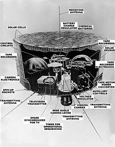
TIROS I was 19 inch (0.4826 m) tall and 42 inches (1.1 m) in diameter. Two television cameras were housed in the 270 pounds (122.5 kg) craft, along with two magnetic tape recorders which could be used to store photographs when the satellite was out of communications range. Power was supplied by onboard batteries, charged by 9200 solar cell
Solar cell
A solar cell is a solid state electrical device that converts the energy of light directly into electricity by the photovoltaic effect....
s.
Elgeet Optical, now known as Navitar
Navitar
Founded1973 TypePrivateHeadquartersRochester, New YorkKey PeopleCo-President:Jeremy Goldstein,Co-President: Julian GoldsteinIndustrySemiconductor, Biotechnology, Homeland Security, Food & Beverage, Metrology, Simulation, Presentation Products...
, produced the optical system for the TIROS-1. The Elgeet Navitar 8mm F1.5 super wide angle lens, attached to a slow-scan camera device that took snapshots of the sky beneath it every 10 seconds. The camera and lens combination weighed only 4.5 pounds. With the wide angle lens, the camera provided a clear view of earth from space 750 miles away. The TIROS I and Tiros II prototype designed for ground testing, hangs in front of a mosaic of TIROS images at the Smithsonian National Air and Space Museum (see photo at right. The prototype includes the Elgeet Navitar lens, which protruding from the bottom of the satellite.
TIROS-1 was named an IEEE Milestone in 2010.
External links
- 1960-002B, the NSSDCNational Space Science Data CenterThe National Space Science Data Center serves as the permanent archive for NASA space science mission data. "Space science" pertains to astronomy and astrophysics, solar and space plasma physics, and planetary and lunar science...
IDInternational DesignatorThe International Designator, also known as COSPAR designation, and in the United States as NSSDC ID, is an international naming convention for satellites...
for TIROS-1 from the NASANASAThe National Aeronautics and Space Administration is the agency of the United States government that is responsible for the nation's civilian space program and for aeronautics and aerospace research...
website - TIROS – NASA Science
- The Smithsonian National Air & Space Museum Exhibition List
- http://campevans.org/_CE/html/tiros1-2.htmlTIROS 1 & 2 Ground Control Canter at Camp Evans - preserved by InfoAge Scieence History Center
- {http://campevans.org/_CE/html/mm-1960-04-07-p1-tiros-signal-pilots-fly-photos-to-NASA.html Published story of how the first TIROS photo was flown by helicoper, then a jet from the Camp Evans Ground Control Center to NASA