

Menstrie
Encyclopedia
Menstrie is a village in the county of Clackmannanshire
in Scotland
, UK. It is about 5 miles (8 kilometres) east-north-east of Stirling
. It is one of a string of towns that, because of their location at the base of the Ochil Hills
, are collectively referred to as the Hillfoots Villages
or simply The Hillfoots.
or flood plain of the River Devon
, between 10 and 20 metres altitude above sea level. It is roughly astride the Ochil Fault
whose movement gave rise to the dramatic southern scarp of the Ochils but which is now almost quiescent.
Two of the most westerly summits of the Ochil Hills, Dumyat
and Myreton Hill
, rise steeply to the north of the village to reach about 400m altitude. These two hills are divided by Menstrie Glen
, from which the small watercourse of Menstrie Burn emerges and runs through the village. About a kilometre to the south, the burn joins the River Devon
which in turn meets the River Forth
at Cambus
.
), a pharmacy
, two pubs (The Holly Tree and the Burnside Inn) and a petrol station. Menstrie also has a library, small sports centre, public park, primary school, a residential establishment for older people and two churches; one being Menstrie Parish Church (Church of Scotland
) and the other being of the United Free Church of Scotland
.
from Stirling to St Andrews
. Bus services run to Stirling
via Stirling University, to Alloa
via Alva
and Tillicoultry
or via Tullibody
, and less frequently to St Andrews. Beginnining in late 2010, bus services also run to Clackmannan
and to Falkirk
(the Falkirk District Royal Infirmary) via Alloa
.
for access to some mine workings, which produced calcite
. However, the volume of material mined was rather small in proportion to the effort needed to build the road, so the venture is unlikely to have been economic. There seems to be no record of why calcite was considered to be sufficiently valuable to have justified the considerable effort.
The occupants of Menstrie once processed wool
from sheep farmed on the Ochils.
In 1800, businessmen from Tullibody
set up a carding
and spinning
mill on the east side of the Menstrie Burn to exploit its soft water and power,
absent from their own village.
In the early 19th century a straight road was built on the flat ground of the carse
or floodplain
to by-pass the old Hillfoots Road and improve the transport of goods to and from the Hillfoots villages. Menstrie's Long Row and Ochil Road lie on the old route along the foot of the hills. The new road, now the A91
, became a focus for construction of churches, houses, mills and shops.
By the mid-19th century, the Elmbank and Forthvale mills were in business on either side of the Menstrie Burn.
In 1841, Menstrie's population was about 500 but had increased to more than 900 by 1881.
In the 1860s a company, which included the owners of local mills and a distillery,
financed a branch railway line through Menstrie to a terminus in Alva
.
This joined the old North British Railway
(N.B.R.) line between Alloa
and Stirling
at Cambus. Menstrie had its own passenger station at the North end of Tullibody Road. Practically nothing of the station remains and the railway branch line, which continued to carry freight after the Beeching Axe
, fell into disuse during the mid-1980s in favour of road transport.
The Glenochil Distillery had opened in the middle 18th century
on the site of the Doll Farm to the east of the village, beside the Dams Burn.
Manufacturing has continued on this site for more than 250 years
though production of whisky
stopped around 1930.
Yeast
, initially a by-product of whisky fermentation, had gradually become the main product
and went for manufacture of whisky and bread. Soft water, locally available, is still useful.
An extensive bonded warehouse
area remains for storage of whisky as it
matures in barrels before bottling,
while bakers' yeast has given way to fermentation products derived from yeast.
The whisky and yeast businesses are now operated by separate companies, respectively: Diageo
,
(successors to Distillers Company); and Kerry Group
. The latter conducts product development as well as manufacturing at the Menstrie site.
The Forthvale Mill no longer stands but the Elmbank Mill,
having been used for some years as offices by the Water Board
, now houses small businesses.
A furniture factory, The Charrier, stood near the Menstrie Burn but was destroyed by fire in about 1968. A street nearby now bears its name.
In the mid-20th Century, Menstrie (pop. 1200 - 1300)
was home to families whose menfolk worked the Clackmannanshire Coalfield and other mines in Central Scotland.
As the mining and textile industries have declined, Menstrie has become a commuter dormitory, spreading over the adjacent farmland. At the Census in 2001 Menstrie's population was 2011 and had increased to an estimated 2640 by the middle of 2008.
Menstrie and the nearby Blairlogie
are access points to Dumyat
, a peak in the Ochil Hills popular with hillwalkers. Menstrie also provides access to Myreton Hill
, used by paragliders
.
The disused railway line served as an unofficial walking route to Tullibody
over the bridge across the River Devon
. In October 2007 Clackmannanshire Council published a map which designated part of the railway line, by then heavily overgrown, as an Aspirational Core Path linking Menstrie and Cambus. By February 2010 the branch line had been sold by BRB (Residuary) Limited
and by March 2011 the rails and sleepers had all been removed. Work on the path is scheduled to be completed by April 2012.
"Fox Boy", a work by the sculptor Andy Scott, stands in the centre of Menstrie in Midtown Gardens (now named the "Nova Scotia Gardens" to commemorate the village's historical connection). The sculpture combines references to the water wheel
s that once powered industry in Menstrie, a pet fox kept by a Menstrie child years ago, and the buzzards
that frequent the skies over the village.
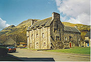 Menstrie Castle
was the birthplace of Sir William Alexander
, James VI’s Chartered Lieutenant for the Plantation of Nova Scotia
. Despite its name, it is described as a "three-storey castellated house", and lacks many fortified features, standing as it does on low ground and constructed at a time of relative national calm. The building is now residential and has won a Civic Trust
award.
The old (pre-19th century) bridge over the Menstrie Burn is listed by The Royal Commission on the Ancient and Historical Monuments of Scotland under number 219364.
In 1874 James Johnstone
, one of the partners in the Elmbank Mill, had built for himself the Scottish baronial-style Broom Hall
on the lower slope of Myreton Hill
. It was burned out in the 1940s and stood as an abandoned shell until 1985 when it was converted into a nursing home. It has since been refurbished as a restaurant.
As a commuter town
Menstrie has undergone a period of expansion since 2000, with new housing built to the west and south of the village.
The firm responsible for maintenance of common areas around the new housing is currently (spring 2011) in dispute with an association of residents. The residents complain that: the maintenance work fails to meet standards stated in the deeds; that the charges are excessive; and that the company has resorted to excessively heavy-handed methods to extract payment, accusations the company rejects.
In December 2009, Clackmannanshire Council announced an alteration to the local development plan for housing land. This allowed for construction of 175 new housing units, including 36 termed 'affordable', to the south-east of the village. The Council subsequently modified the plan as recommended by a Reporter appointed by Scottish Ministers. In the absence of further directions from the ministers, the council formally adopted the modified plan in the autumn of 2011. Among other stipulations and guidelines the modified plan as adopted allowed for 175 housing units, 43 affordable; and required a detailed Flood Risk Assessment to determine ground conditions and water management needs on and for the site.
Clackmannanshire
Clackmannanshire, often abbreviated to Clacks is a local government council area in Scotland, and a lieutenancy area, bordering Perth and Kinross, Stirling and Fife.As Scotland's smallest historic county, it is often nicknamed 'The Wee County'....
in Scotland
Scotland
Scotland is a country that is part of the United Kingdom. Occupying the northern third of the island of Great Britain, it shares a border with England to the south and is bounded by the North Sea to the east, the Atlantic Ocean to the north and west, and the North Channel and Irish Sea to the...
, UK. It is about 5 miles (8 kilometres) east-north-east of Stirling
Stirling
Stirling is a city and former ancient burgh in Scotland, and is at the heart of the wider Stirling council area. The city is clustered around a large fortress and medieval old-town beside the River Forth...
. It is one of a string of towns that, because of their location at the base of the Ochil Hills
Ochil Hills
The Ochil Hills is a range of hills in Scotland north of the Forth valley bordered by the towns of Stirling, Alloa, Kinross and Perth. The only major roads crossing the hills pass through Glen Devon/Glen Eagles and Glenfarg, the latter now largely replaced except for local traffic by the M90...
, are collectively referred to as the Hillfoots Villages
Hillfoots Villages
The Hillfoots Villages are the villages and small towns which lie at the base of the southern scarp face of the Ochil Hills, formed by the Ochil Fault, in Stirlingshire and Clackmannanshire in central Scotland....
or simply The Hillfoots.
Physical geography
Menstrie stands on the carseCarse
In Scottish geography, a Carse is an area of low-lying, typically alluvial and fertile land occupying certain Scottish river valleys, such as that of the River Forth.-Carse of Forth :...
or flood plain of the River Devon
River Devon, Clackmannanshire
The River Devon is a tributary of the River Forth in Clackmannanshire, Scotland.-Geography:The source of the river is Blairdenon Hill in the Ochils at an altitude of ....
, between 10 and 20 metres altitude above sea level. It is roughly astride the Ochil Fault
Ochil Fault
The Ochil Fault is the geological feature which defines the southern edge of the Ochil Hills escarpment, Scotland.North of the fault, Devonian lava flows and pyroclastic deposits slope gently down, thinning towards the north. These are in part overlain by Old Red Sandstone rocks formed later in the...
whose movement gave rise to the dramatic southern scarp of the Ochils but which is now almost quiescent.
Two of the most westerly summits of the Ochil Hills, Dumyat
Dumyat
Dumyat is a hill at the western extremity of the Ochil Hills in central Scotland. The name is thought to originate from Dun of the Maeatae....
and Myreton Hill
Myreton Hill
Myreton Hill is the hill immediately behind the village of Menstrie in the Ochil Hills of Scotland. See the for location.The track up the scarp face of Myreton Hill leads to some calcite workings which date from the Napoleonic Wars...
, rise steeply to the north of the village to reach about 400m altitude. These two hills are divided by Menstrie Glen
Menstrie Glen
Menstrie Glen is the valley which separates Dumyat from Myreton Hill and the main body of the Ochil Hills in Scotland. Once farmed but no longer inhabited, it is now used for sheep pasture, a public water supply and recreation in the form of fishing and walking.-Vegetation and topography:Much of...
, from which the small watercourse of Menstrie Burn emerges and runs through the village. About a kilometre to the south, the burn joins the River Devon
River Devon, Clackmannanshire
The River Devon is a tributary of the River Forth in Clackmannanshire, Scotland.-Geography:The source of the river is Blairdenon Hill in the Ochils at an altitude of ....
which in turn meets the River Forth
River Forth
The River Forth , long, is the major river draining the eastern part of the central belt of Scotland.The Forth rises in Loch Ard in the Trossachs, a mountainous area some west of Stirling...
at Cambus
Cambus
Cambus is a public transport bus system, primarily serving the University of Iowa campus in Iowa City, IA. The service is intended to provide transportation for students, faculty, and staff around the main campus, University of Iowa Research Park, residence halls, and commuter parking lots. Cambus...
.
Facilities
The village has two general stores (one containing the Post OfficePost office
A post office is a facility forming part of a postal system for the posting, receipt, sorting, handling, transmission or delivery of mail.Post offices offer mail-related services such as post office boxes, postage and packaging supplies...
), a pharmacy
Pharmacy
Pharmacy is the health profession that links the health sciences with the chemical sciences and it is charged with ensuring the safe and effective use of pharmaceutical drugs...
, two pubs (The Holly Tree and the Burnside Inn) and a petrol station. Menstrie also has a library, small sports centre, public park, primary school, a residential establishment for older people and two churches; one being Menstrie Parish Church (Church of Scotland
Church of Scotland
The Church of Scotland, known informally by its Scots language name, the Kirk, is a Presbyterian church, decisively shaped by the Scottish Reformation....
) and the other being of the United Free Church of Scotland
United Free Church of Scotland
The United Free Church of Scotland is a Scottish Presbyterian denomination formed in 1900 by the union of the United Presbyterian Church of Scotland and the Free Church of Scotland...
.
Transport links
Menstrie is on the A91 roadA91 road
The A91 is a major road in Scotland, United Kingdom. It runs from St Andrews to Bannockburn, via Cupar. Along the way, the road runs adjacent to parts of the St. Andrews Old Course and Jubilee golf courses into Guardbridge. Past Guardbridge is Clayton Caravan Park. Further towards Cupar is the Eden...
from Stirling to St Andrews
St Andrews
St Andrews is a university town and former royal burgh on the east coast of Fife in Scotland. The town is named after Saint Andrew the Apostle.St Andrews has a population of 16,680, making this the fifth largest settlement in Fife....
. Bus services run to Stirling
Stirling
Stirling is a city and former ancient burgh in Scotland, and is at the heart of the wider Stirling council area. The city is clustered around a large fortress and medieval old-town beside the River Forth...
via Stirling University, to Alloa
Alloa
Alloa is a town and former burgh in Clackmannanshire, set in the Central Lowlands of Scotland. It lies on on the north bank of the Firth of Forth close to the foot of the Ochil Hills, east of Stirling and north of Falkirk....
via Alva
Alva, Clackmannanshire
Alva is a small town in Clackmannanshire, set in the Central Lowlands of Scotland. It is one of a number of towns situated immediately to the south of the Ochil Hills, collectively referred to as the Hillfoots Villages or simply The Hillfoots...
and Tillicoultry
Tillicoultry
Tillicoultry...
or via Tullibody
Tullibody
Tullibody is a town set in the Central Lowlands of Scotland. It lies north of the River Forth near to the foot of the Ochil Hills within the Forth Valley. The town is south-west of Alva, north-west of Alloa and east-northeast of Stirling...
, and less frequently to St Andrews. Beginnining in late 2010, bus services also run to Clackmannan
Clackmannan, Clackmannanshire
Clackmannan , is a small town set in the Central Lowlands of Scotland. Situated within the Forth Valley, Clackmannan is south-east of Alloa and south of Tillicoultry...
and to Falkirk
Falkirk
Falkirk is a town in the Central Lowlands of Scotland. It lies in the Forth Valley, almost midway between the two most populous cities of Scotland; north-west of Edinburgh and north-east of Glasgow....
(the Falkirk District Royal Infirmary) via Alloa
Alloa
Alloa is a town and former burgh in Clackmannanshire, set in the Central Lowlands of Scotland. It lies on on the north bank of the Firth of Forth close to the foot of the Ochil Hills, east of Stirling and north of Falkirk....
.
Industry and population
A conspicuous zig-zag roadway up the scarp face of Myreton Hill, nowadays used by the local sheep farmer for access to his livestock, was originally built during the Napoleonic WarsNapoleonic Wars
The Napoleonic Wars were a series of wars declared against Napoleon's French Empire by opposing coalitions that ran from 1803 to 1815. As a continuation of the wars sparked by the French Revolution of 1789, they revolutionised European armies and played out on an unprecedented scale, mainly due to...
for access to some mine workings, which produced calcite
Calcite
Calcite is a carbonate mineral and the most stable polymorph of calcium carbonate . The other polymorphs are the minerals aragonite and vaterite. Aragonite will change to calcite at 380-470°C, and vaterite is even less stable.-Properties:...
. However, the volume of material mined was rather small in proportion to the effort needed to build the road, so the venture is unlikely to have been economic. There seems to be no record of why calcite was considered to be sufficiently valuable to have justified the considerable effort.
The occupants of Menstrie once processed wool
Wool
Wool is the textile fiber obtained from sheep and certain other animals, including cashmere from goats, mohair from goats, qiviut from muskoxen, vicuña, alpaca, camel from animals in the camel family, and angora from rabbits....
from sheep farmed on the Ochils.
In 1800, businessmen from Tullibody
Tullibody
Tullibody is a town set in the Central Lowlands of Scotland. It lies north of the River Forth near to the foot of the Ochil Hills within the Forth Valley. The town is south-west of Alva, north-west of Alloa and east-northeast of Stirling...
set up a carding
Carding
Carding is a mechanical process that breaks up locks and unorganised clumps of fibre and then aligns the individual fibres so that they are more or less parallel with each other. The word is derived from the Latin carduus meaning teasel, as dried vegetable teasels were first used to comb the raw wool...
and spinning
Spinning (textiles)
Spinning is a major industry. It is part of the textile manufacturing process where three types of fibre are converted into yarn, then fabric, then textiles. The textiles are then fabricated into clothes or other artifacts. There are three industrial processes available to spin yarn, and a...
mill on the east side of the Menstrie Burn to exploit its soft water and power,
absent from their own village.
In the early 19th century a straight road was built on the flat ground of the carse
Carse
In Scottish geography, a Carse is an area of low-lying, typically alluvial and fertile land occupying certain Scottish river valleys, such as that of the River Forth.-Carse of Forth :...
or floodplain
Floodplain
A floodplain, or flood plain, is a flat or nearly flat land adjacent a stream or river that stretches from the banks of its channel to the base of the enclosing valley walls and experiences flooding during periods of high discharge...
to by-pass the old Hillfoots Road and improve the transport of goods to and from the Hillfoots villages. Menstrie's Long Row and Ochil Road lie on the old route along the foot of the hills. The new road, now the A91
A91 road
The A91 is a major road in Scotland, United Kingdom. It runs from St Andrews to Bannockburn, via Cupar. Along the way, the road runs adjacent to parts of the St. Andrews Old Course and Jubilee golf courses into Guardbridge. Past Guardbridge is Clayton Caravan Park. Further towards Cupar is the Eden...
, became a focus for construction of churches, houses, mills and shops.
By the mid-19th century, the Elmbank and Forthvale mills were in business on either side of the Menstrie Burn.
In 1841, Menstrie's population was about 500 but had increased to more than 900 by 1881.
In the 1860s a company, which included the owners of local mills and a distillery,
financed a branch railway line through Menstrie to a terminus in Alva
Alva, Clackmannanshire
Alva is a small town in Clackmannanshire, set in the Central Lowlands of Scotland. It is one of a number of towns situated immediately to the south of the Ochil Hills, collectively referred to as the Hillfoots Villages or simply The Hillfoots...
.
This joined the old North British Railway
North British Railway
The North British Railway was a Scottish railway company that was absorbed into the London and North Eastern Railway at the Grouping in 1923.-History:...
(N.B.R.) line between Alloa
Alloa
Alloa is a town and former burgh in Clackmannanshire, set in the Central Lowlands of Scotland. It lies on on the north bank of the Firth of Forth close to the foot of the Ochil Hills, east of Stirling and north of Falkirk....
and Stirling
Stirling
Stirling is a city and former ancient burgh in Scotland, and is at the heart of the wider Stirling council area. The city is clustered around a large fortress and medieval old-town beside the River Forth...
at Cambus. Menstrie had its own passenger station at the North end of Tullibody Road. Practically nothing of the station remains and the railway branch line, which continued to carry freight after the Beeching Axe
Beeching Axe
The Beeching Axe or the Beeching Cuts are informal names for the British Government's attempt in the 1960s to reduce the cost of running British Railways, the nationalised railway system in the United Kingdom. The name is that of the main author of The Reshaping of British Railways, Dr Richard...
, fell into disuse during the mid-1980s in favour of road transport.
The Glenochil Distillery had opened in the middle 18th century
on the site of the Doll Farm to the east of the village, beside the Dams Burn.
Manufacturing has continued on this site for more than 250 years
though production of whisky
Whisky
Whisky or whiskey is a type of distilled alcoholic beverage made from fermented grain mash. Different grains are used for different varieties, including barley, malted barley, rye, malted rye, wheat, and corn...
stopped around 1930.
Yeast
Yeast
Yeasts are eukaryotic micro-organisms classified in the kingdom Fungi, with 1,500 species currently described estimated to be only 1% of all fungal species. Most reproduce asexually by mitosis, and many do so by an asymmetric division process called budding...
, initially a by-product of whisky fermentation, had gradually become the main product
and went for manufacture of whisky and bread. Soft water, locally available, is still useful.
An extensive bonded warehouse
Bonded warehouse
A Bonded warehouse is a building or other secured area in which dutiable goods may be stored, manipulated, or undergo manufacturing operations without payment of duty. It may be managed by the state or by private enterprise. In the latter case a customs bond must be posted with the government...
area remains for storage of whisky as it
matures in barrels before bottling,
while bakers' yeast has given way to fermentation products derived from yeast.
The whisky and yeast businesses are now operated by separate companies, respectively: Diageo
Diageo
Diageo plc is a global alcoholic beverages company headquartered in London, United Kingdom. It is the world's largest producer of spirits and a major producer of beer and wine....
,
(successors to Distillers Company); and Kerry Group
Kerry Group
Kerry Group , is a public food company headquartered in Ireland. It is quoted on the Dublin ISEQ and London stock exchanges. It evolved initially from a local dairy co-op in the Munster region of Ireland...
. The latter conducts product development as well as manufacturing at the Menstrie site.
The Forthvale Mill no longer stands but the Elmbank Mill,
having been used for some years as offices by the Water Board
Scottish Water
Scottish Water is a statutory corporation in Scotland that provides water and sewerage services. Unlike in England and Wales, water and sewerage provision in Scotland continues as a public corporation accountable to the public through the Scottish Government....
, now houses small businesses.
A furniture factory, The Charrier, stood near the Menstrie Burn but was destroyed by fire in about 1968. A street nearby now bears its name.
In the mid-20th Century, Menstrie (pop. 1200 - 1300)
was home to families whose menfolk worked the Clackmannanshire Coalfield and other mines in Central Scotland.
As the mining and textile industries have declined, Menstrie has become a commuter dormitory, spreading over the adjacent farmland. At the Census in 2001 Menstrie's population was 2011 and had increased to an estimated 2640 by the middle of 2008.
Recreation
Menstrie's Scout Group was established in 1908.Menstrie and the nearby Blairlogie
Blairlogie
Blairlogie is a village in Stirlingshire, Scotland, situated at the base of the great cliff of Dumyat between Stirling and Menstrie. It was one of central Scotland's earliest Conservation villages...
are access points to Dumyat
Dumyat
Dumyat is a hill at the western extremity of the Ochil Hills in central Scotland. The name is thought to originate from Dun of the Maeatae....
, a peak in the Ochil Hills popular with hillwalkers. Menstrie also provides access to Myreton Hill
Myreton Hill
Myreton Hill is the hill immediately behind the village of Menstrie in the Ochil Hills of Scotland. See the for location.The track up the scarp face of Myreton Hill leads to some calcite workings which date from the Napoleonic Wars...
, used by paragliders
Paragliding
Paragliding is the recreational and competitive adventure sport of flying paragliders: lightweight, free-flying, foot-launched glider aircraft with no rigid primary structure...
.
The disused railway line served as an unofficial walking route to Tullibody
Tullibody
Tullibody is a town set in the Central Lowlands of Scotland. It lies north of the River Forth near to the foot of the Ochil Hills within the Forth Valley. The town is south-west of Alva, north-west of Alloa and east-northeast of Stirling...
over the bridge across the River Devon
River Devon, Clackmannanshire
The River Devon is a tributary of the River Forth in Clackmannanshire, Scotland.-Geography:The source of the river is Blairdenon Hill in the Ochils at an altitude of ....
. In October 2007 Clackmannanshire Council published a map which designated part of the railway line, by then heavily overgrown, as an Aspirational Core Path linking Menstrie and Cambus. By February 2010 the branch line had been sold by BRB (Residuary) Limited
and by March 2011 the rails and sleepers had all been removed. Work on the path is scheduled to be completed by April 2012.
"Fox Boy", a work by the sculptor Andy Scott, stands in the centre of Menstrie in Midtown Gardens (now named the "Nova Scotia Gardens" to commemorate the village's historical connection). The sculpture combines references to the water wheel
Water wheel
A water wheel is a machine for converting the energy of free-flowing or falling water into useful forms of power. A water wheel consists of a large wooden or metal wheel, with a number of blades or buckets arranged on the outside rim forming the driving surface...
s that once powered industry in Menstrie, a pet fox kept by a Menstrie child years ago, and the buzzards
Common Buzzard
The Common Buzzard is a medium to large bird of prey, whose range covers most of Europe and extends into Asia. It is usually resident all year, except in the coldest parts of its range, and in the case of one subspecies.-Description:...
that frequent the skies over the village.
Architecture and housing
Menstrie Castle
Menstrie Castle is a three-storey castellated house in the town of Menstrie, Clackmannanshire, near Stirling, central Scotland. From the early 17th century, it was home to Sir William Alexander, 1st Earl of Stirling, who was instrumental in founding the colony of Nova Scotia. It was later owned by...
was the birthplace of Sir William Alexander
William Alexander, 1st Earl of Stirling
William Alexander, Earl of Stirling was a Scotsman who was an early developer of Scottish colonisation of Port Royal, Nova Scotia and Long Island, New York...
, James VI’s Chartered Lieutenant for the Plantation of Nova Scotia
Nova Scotia
Nova Scotia is one of Canada's three Maritime provinces and is the most populous province in Atlantic Canada. The name of the province is Latin for "New Scotland," but "Nova Scotia" is the recognized, English-language name of the province. The provincial capital is Halifax. Nova Scotia is the...
. Despite its name, it is described as a "three-storey castellated house", and lacks many fortified features, standing as it does on low ground and constructed at a time of relative national calm. The building is now residential and has won a Civic Trust
Civic Trust
The Civic Trust of England was a charitable organisation founded in 1957. It ceased operations in 2009 and went into administration due to lack of funds/...
award.
The old (pre-19th century) bridge over the Menstrie Burn is listed by The Royal Commission on the Ancient and Historical Monuments of Scotland under number 219364.
In 1874 James Johnstone
James Johnstone
James Johnstone was a Scottish biologist and oceanographer. His studies focused on the food chain in marine ecosystems...
, one of the partners in the Elmbank Mill, had built for himself the Scottish baronial-style Broom Hall
Broomhall Castle
Broomhall Castle was originally built by John Foukes and Frances Mackison in 1874, for James Johnstone. It is situated in Menstrie, Clackmannanshire, Scotland on the Ochil Hills and consists of three storeys and a tower. It is currently in use as a hotel....
on the lower slope of Myreton Hill
Myreton Hill
Myreton Hill is the hill immediately behind the village of Menstrie in the Ochil Hills of Scotland. See the for location.The track up the scarp face of Myreton Hill leads to some calcite workings which date from the Napoleonic Wars...
. It was burned out in the 1940s and stood as an abandoned shell until 1985 when it was converted into a nursing home. It has since been refurbished as a restaurant.
As a commuter town
Commuter town
A commuter town is an urban community that is primarily residential, from which most of the workforce commutes out to earn their livelihood. Many commuter towns act as suburbs of a nearby metropolis that workers travel to daily, and many suburbs are commuter towns...
Menstrie has undergone a period of expansion since 2000, with new housing built to the west and south of the village.
The firm responsible for maintenance of common areas around the new housing is currently (spring 2011) in dispute with an association of residents. The residents complain that: the maintenance work fails to meet standards stated in the deeds; that the charges are excessive; and that the company has resorted to excessively heavy-handed methods to extract payment, accusations the company rejects.
In December 2009, Clackmannanshire Council announced an alteration to the local development plan for housing land. This allowed for construction of 175 new housing units, including 36 termed 'affordable', to the south-east of the village. The Council subsequently modified the plan as recommended by a Reporter appointed by Scottish Ministers. In the absence of further directions from the ministers, the council formally adopted the modified plan in the autumn of 2011. Among other stipulations and guidelines the modified plan as adopted allowed for 175 housing units, 43 affordable; and required a detailed Flood Risk Assessment to determine ground conditions and water management needs on and for the site.