

River Devon, Clackmannanshire
Encyclopedia
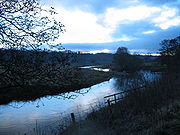
River Forth
The River Forth , long, is the major river draining the eastern part of the central belt of Scotland.The Forth rises in Loch Ard in the Trossachs, a mountainous area some west of Stirling...
in Clackmannanshire
Clackmannanshire
Clackmannanshire, often abbreviated to Clacks is a local government council area in Scotland, and a lieutenancy area, bordering Perth and Kinross, Stirling and Fife.As Scotland's smallest historic county, it is often nicknamed 'The Wee County'....
, Scotland
Scotland
Scotland is a country that is part of the United Kingdom. Occupying the northern third of the island of Great Britain, it shares a border with England to the south and is bounded by the North Sea to the east, the Atlantic Ocean to the north and west, and the North Channel and Irish Sea to the...
.
Geography
The source of the river is Blairdenon Hill in the Ochils at an altitude of 1800 feet (548.6 m).Upper areas have been dammed, creating Upper Glendevon, Lower Glendevon and Castlehill reservoirs.
The Devon then flows east and southeast through Glendevon, turning southwest at Crook of Devon
Crook of Devon
Crook of Devon is a village within the parish of Fossoway in Perthshire. It is located about 6 miles southwest of Kinross on the A977. Until relatively recently the official name of the village was Fossoway but this has been usurped by the widely used nickname "crook of devon"...
and then continuing westwards, meandering across its flood plain along the foot of the Ochil Hills. It reaches the River Forth
River Forth
The River Forth , long, is the major river draining the eastern part of the central belt of Scotland.The Forth rises in Loch Ard in the Trossachs, a mountainous area some west of Stirling...
to the west of Alloa
Alloa
Alloa is a town and former burgh in Clackmannanshire, set in the Central Lowlands of Scotland. It lies on on the north bank of the Firth of Forth close to the foot of the Ochil Hills, east of Stirling and north of Falkirk....
at the small village of Cambus.
History and culture
During the Scottish ReformationScottish Reformation
The Scottish Reformation was Scotland's formal break with the Papacy in 1560, and the events surrounding this. It was part of the wider European Protestant Reformation; and in Scotland's case culminated ecclesiastically in the re-establishment of the church along Reformed lines, and politically in...
, William Kirkcaldy destroyed the bridge at Tullibody in attempt to prevent French troops retreating to the Siege of Leith
Siege of Leith
The Siege of Leith ended a twelve year encampment of French troops at Leith, the port near Edinburgh, Scotland. The French troops arrived by invitation in 1548 and left in 1560 after the English arrived to assist in removing them from Scotland...
at the end of January 1560. However, the French took down the roof of Tullibody Kirk
Tullibody Old Kirk
Tullibody Old Kirk is a ruined 12th-century church in Tullibody, Clackmannanshire, Scotland. It was rebuilt in the 16th century, and restored again in 1760. The roofless building is protected as a Category A listed building, and a Scheduled Ancient Monument. In 1904, St Serf's Parish Church was...
to bridge the Devon.
The Devon was surveyed by James Watt
James Watt
James Watt, FRS, FRSE was a Scottish inventor and mechanical engineer whose improvements to the Newcomen steam engine were fundamental to the changes brought by the Industrial Revolution in both his native Great Britain and the rest of the world.While working as an instrument maker at the...
in 1766, who claimed that by deepening the river bed it might be navigable as far as Dollar
Dollar, Clackmannanshire
Dollar is a small town in Clackmannanshire, Scotland. It is one of the Hillfoots Villages, situated between the Ochil Hills range to the north and the River Devon to the south. Dollar is on the A91 road, which runs from Stirling to St. Andrews. The town is around 3 miles east of Tillicoultry...
. The estimated cost of such a project was £2000.
Two songs The Banks of the Devon and Fairest Maid on Devon Bank were written in 1787 by Robert Burns
Robert Burns
Robert Burns was a Scottish poet and a lyricist. He is widely regarded as the national poet of Scotland, and is celebrated worldwide...
, which recall Charlotte Hamilton of Mauchline
Mauchline
Mauchline is a town in East Ayrshire, Scotland. In the 2001 census it had a recorded population of 4105. It lies by the Glasgow and South Western Railway line, 8 miles east-southeast of Kilmarnock and 11 miles northeast of Ayr. It is situated on a gentle slope about 1 mile from the River Ayr,...
whom he had met at nearby Harviestoun
Harviestoun
Harviestoun, is an estate in Tillicoultry parish, Clackmannanshire. It lies at the base of the Ochil Hills, East-North-East of the town. Harviestoun Castle, was built in 1804 by Craufurd Tait after inheriting the estate from his father John Tait in 1800...
estate.
Flooding
Clackmannanshire Council has recognised the threat of flooding along the Devon and has worked to address the issue on its own account and in partnership with others, including WWF-Scotland. Works undertaken on the Devon catchment include willow walling, riverside woodland and the blocking of wetland drains.In January 2008 the Devon catchment area was ‘Very Wet’. Land became saturated and rainfall resulted in run-off into rivers, reaching the river system very quickly. River flows in the region were ‘Exceptionally High’. Upstream, all the Ochil reservoirs were full with Castlehill reservoir overflowing for all of that month. The flood at the upstream gauge at Castlehill was the second highest recorded. Further downstream, the water level recorded at Glenochil was the highest since records began in 1956.
Over the period of 25 - 26 January 2008, residential and commercial properties in part of Tillicoultry
Tillicoultry
Tillicoultry...
were inundated. The extent of flooding was greater than had been experienced in the past and the Council appointed specialist hydrological consultants to investigate the contributory factors and advise on measures available to minimise or eliminate any future occurrence.
In November 2008 and again in November 2009 extensive flooding occurred in the Hillfoots making several road bridges across the river impassable. No houses were damaged on those two occasions.