

Ochil Fault
Encyclopedia
Ochil Hills
The Ochil Hills is a range of hills in Scotland north of the Forth valley bordered by the towns of Stirling, Alloa, Kinross and Perth. The only major roads crossing the hills pass through Glen Devon/Glen Eagles and Glenfarg, the latter now largely replaced except for local traffic by the M90...
escarpment, Scotland
Scotland
Scotland is a country that is part of the United Kingdom. Occupying the northern third of the island of Great Britain, it shares a border with England to the south and is bounded by the North Sea to the east, the Atlantic Ocean to the north and west, and the North Channel and Irish Sea to the...
.
North of the fault, Devonian
Devonian
The Devonian is a geologic period and system of the Paleozoic Era spanning from the end of the Silurian Period, about 416.0 ± 2.8 Mya , to the beginning of the Carboniferous Period, about 359.2 ± 2.5 Mya...
lava
Lava
Lava refers both to molten rock expelled by a volcano during an eruption and the resulting rock after solidification and cooling. This molten rock is formed in the interior of some planets, including Earth, and some of their satellites. When first erupted from a volcanic vent, lava is a liquid at...
flows and pyroclastic deposits slope gently down, thinning towards the north. These are in part overlain by Old Red Sandstone rocks formed later in the Devonian
Devonian
The Devonian is a geologic period and system of the Paleozoic Era spanning from the end of the Silurian Period, about 416.0 ± 2.8 Mya , to the beginning of the Carboniferous Period, about 359.2 ± 2.5 Mya...
period. Because the deposits thin towards the north, and there are few signs of volcanic necks within the Ochil Hills
Ochil Hills
The Ochil Hills is a range of hills in Scotland north of the Forth valley bordered by the towns of Stirling, Alloa, Kinross and Perth. The only major roads crossing the hills pass through Glen Devon/Glen Eagles and Glenfarg, the latter now largely replaced except for local traffic by the M90...
themselves, it is thought that the eruptive centres were south of the fault
Geologic fault
In geology, a fault is a planar fracture or discontinuity in a volume of rock, across which there has been significant displacement along the fractures as a result of earth movement. Large faults within the Earth's crust result from the action of tectonic forces...
, however these are buried deep beneath the Carboniferous
Carboniferous
The Carboniferous is a geologic period and system that extends from the end of the Devonian Period, about 359.2 ± 2.5 Mya , to the beginning of the Permian Period, about 299.0 ± 0.8 Mya . The name is derived from the Latin word for coal, carbo. Carboniferous means "coal-bearing"...
rocks including coal measures
Coal Measures
The Coal Measures is a lithostratigraphical term for the coal-bearing part of the Upper Carboniferous System. It represents the remains of fluvio-deltaic sediment, and consists mainly of clastic rocks interstratified with the beds of coal...
which are found beneath the low-lying carse lands to the south.
To put this in perspective, the prominent hill Dumyat
Dumyat
Dumyat is a hill at the western extremity of the Ochil Hills in central Scotland. The name is thought to originate from Dun of the Maeatae....
which defines the western extremity of the Ochil Hills
Ochil Hills
The Ochil Hills is a range of hills in Scotland north of the Forth valley bordered by the towns of Stirling, Alloa, Kinross and Perth. The only major roads crossing the hills pass through Glen Devon/Glen Eagles and Glenfarg, the latter now largely replaced except for local traffic by the M90...
has a height of 418 metres. The nearest colliery, Manor Powis, approximately 2 km south of the fault, was approximately the same depth, in carse land that is scarcely above sea level, and was mining coal from Carboniferous
Carboniferous
The Carboniferous is a geologic period and system that extends from the end of the Devonian Period, about 359.2 ± 2.5 Mya , to the beginning of the Permian Period, about 299.0 ± 0.8 Mya . The name is derived from the Latin word for coal, carbo. Carboniferous means "coal-bearing"...
strata at least many hundreds of metres above the top of the Devonian
Devonian
The Devonian is a geologic period and system of the Paleozoic Era spanning from the end of the Silurian Period, about 416.0 ± 2.8 Mya , to the beginning of the Carboniferous Period, about 359.2 ± 2.5 Mya...
deposits. The Ochil Fault must have been active from the earliest part of the Carboniferous
Carboniferous
The Carboniferous is a geologic period and system that extends from the end of the Devonian Period, about 359.2 ± 2.5 Mya , to the beginning of the Permian Period, about 299.0 ± 0.8 Mya . The name is derived from the Latin word for coal, carbo. Carboniferous means "coal-bearing"...
period, allowing the marine swamps in which the coal-producing vegetation flourished to be periodically overlain by layers of sand, forming sandstone, or silt, forming shale, in a number of cyclic subsidences. These occurred in the form of basins, and the pattern of movements was complex, however it is known that the greatest vertical movement was centred about 1 km east of the town of Alva, and almost certainly exceeded 5 km vertically. The deepest deposits of coal measures
Coal Measures
The Coal Measures is a lithostratigraphical term for the coal-bearing part of the Upper Carboniferous System. It represents the remains of fluvio-deltaic sediment, and consists mainly of clastic rocks interstratified with the beds of coal...
are obviously found in this region, but surprisingly this has not been mined, probably due to the great depth involved.
The point of maximum downwards movement south of the fault lies just south of the Silver Glen
Silver Glen
The Silver Glen lies approximately 1 km to the east of the town of Alva, Clackmannanshire, Scotland, and takes its name from the silver that was mined there in the early 18th century. The story of the silver mine is a remarkable one...
, which happens to be the part of the Ochil Hills where the greatest extent of mineralisation has been discovered. The minerals, including ores of silver
Silver
Silver is a metallic chemical element with the chemical symbol Ag and atomic number 47. A soft, white, lustrous transition metal, it has the highest electrical conductivity of any element and the highest thermal conductivity of any metal...
and cobalt
Cobalt
Cobalt is a chemical element with symbol Co and atomic number 27. It is found naturally only in chemically combined form. The free element, produced by reductive smelting, is a hard, lustrous, silver-gray metal....
, were probably emplaced by hydrothermal solutions percolating upwards through various minor faults and fractures, in the Tertiary
Tertiary
The Tertiary is a deprecated term for a geologic period 65 million to 2.6 million years ago. The Tertiary covered the time span between the superseded Secondary period and the Quaternary...
period.
The Ochil Fault remained active throughout geological time, and some later movements allowed intrusive eruptions of diorite
Diorite
Diorite is a grey to dark grey intermediate intrusive igneous rock composed principally of plagioclase feldspar , biotite, hornblende, and/or pyroxene. It may contain small amounts of quartz, microcline and olivine. Zircon, apatite, sphene, magnetite, ilmenite and sulfides occur as accessory...
or quartz-dolerite
Quartz-dolerite
An intrusive rock, similar to dolerite, but with an excess of quartz. Dolerite is similar in composition to basalt, which is eruptive , and gabbro, which is plutonic. The differing crystal sizes are due to the different rate of cooling, basalt cools quickly and has a very fine structure, while...
to rise at various places along its length. One such intrusion was until recently quarried for roadstone at Tillicoultry
Tillicoultry
Tillicoultry...
.
Modern movements of the fault are very minor but occasionally give rise to discernible earthquakes, particularly in the village of Menstrie
Menstrie
Menstrie is a village in the county of Clackmannanshire in Scotland, UK. It is about 5 miles east-north-east of Stirling...
, and the town of Tillicoultry. However the latter may be easily confused with the collapse of old room and pillar coal mine workings which undoubtedly underlie the southern part of the town.
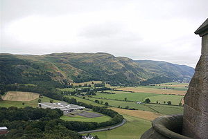
The Ochil Fault is one of Britain's finest examples of a fault line
Fault line
In geology, fault line refers to the surface trace of a fault.Fault line, Fault Line, or faultline may also refer to:* "Faultline", a song from the 2008 studio album Versus by The Haunted...
scarp, and can be best appreciated from vantage points such as the Wallace Monument
Wallace Monument
The National Wallace Monument is a tower standing on the summit of Abbey Craig, a hilltop near Stirling in Scotland. It commemorates Sir William Wallace, the 13th century Scottish hero....
near Stirling
Stirling
Stirling is a city and former ancient burgh in Scotland, and is at the heart of the wider Stirling council area. The city is clustered around a large fortress and medieval old-town beside the River Forth...
.