

Malaysian Federal Roads System
Encyclopedia
Malaysian Public Works Department
Malaysian Public Works Department ' or Jabatan Kerja Raya Malaysia ' is the federal government department in Malaysia under Malaysian Ministry of Works which is responsible for construction and maintenance of public infrastructure in Malaysia such as federal and state roads, public government...
(JKR) which are also one of the implementing agency under the MOW (with exception of Sabah and Sarawak, whereby JKR in these two states is under respective state government).
History
Most of the federal roads in Peninsular MalaysiaPeninsular Malaysia
Peninsular Malaysia , also known as West Malaysia , is the part of Malaysia which lies on the Malay Peninsula. Its area is . It shares a land border with Thailand in the north. To the south is the island of Singapore. Across the Strait of Malacca to the west lies the island of Sumatra...
were built during the British
British Empire
The British Empire comprised the dominions, colonies, protectorates, mandates and other territories ruled or administered by the United Kingdom. It originated with the overseas colonies and trading posts established by England in the late 16th and early 17th centuries. At its height, it was the...
colonial era before 1957. At that time, the British government built the roads in order to enable them to transport goods and commodities easier.
In Sabah
Sabah
Sabah is one of 13 member states of Malaysia. It is located on the northern portion of the island of Borneo. It is the second largest state in the country after Sarawak, which it borders on its southwest. It also shares a border with the province of East Kalimantan of Indonesia in the south...
, most of the federal roads were built during the occupation of British North Borneo under North Borneo Chartered Company
British North Borneo Company
The North Borneo Chartered Company or British North Borneo Company was a chartered company assigned to administer North Borneo in August 1881. North Borneo became a protectorate of the British Empire with internal affairs administered by the company until 1946 when it became the colony of British...
administration, and unlike most federal roads in Peninsular Malaysia which uses only numbers to label federal roads, Sabah federal road codes begin with the letter A followed by route number.
However, in Sarawak
Sarawak
Sarawak is one of two Malaysian states on the island of Borneo. Known as Bumi Kenyalang , Sarawak is situated on the north-west of the island. It is the largest state in Malaysia followed by Sabah, the second largest state located to the North- East.The administrative capital is Kuching, which...
, no road network system was developed during the rule of White Rajah Brooke
Raja Brooke
Rajah Brooke's Birdwing is a distinctive black and electric-green birdwing butterfly from the rainforests in the Thai-Malay Peninsula, Borneo, Natuna and various small islands west of Sumatra . The butterfly was named by the naturalist Alfred R...
dynasty. As a result, right after Sarawak joined the federation of Malaysia on 16 September 1963, the federal government of Malaysia began to built a road network system connecting Sarawak to Sabah, known as Pan Borneo Highway
Pan Borneo Highway
Pan Borneo Highway , also known as Trans Borneo Highway, , ' is a network of federal roads connecting Sarawak, Brunei and Sabah. The Pan Borneo Highway project is a joint project between the governments of Brunei and Malaysia...
.
Overview
The total length of federal roads is 49935 km (31,028.2 mi).Federal routes are labeled with only numbers for example Federal Route while state routes are labeled with the state code letter followed by assigned numbers, for example Route is a Johor
Johor
Johor is a Malaysian state, located in the southern portion of Peninsular Malaysia. It is one of the most developed states in Malaysia. The state capital city and royal city of Johor is Johor Bahru, formerly known as Tanjung Puteri...
state road. However, federal route numbers can also be added with the prefix, which is normally used by JKR and Malaysian police
Royal Malaysian Police
The Royal Malaysia Police is a part of the security forces structure in Malaysia. The force is a centralised organization with responsibilities ranging from traffic control to intelligence gathering. Its headquarters is located at Bukit Aman, Kuala Lumpur. The police force is led by an...
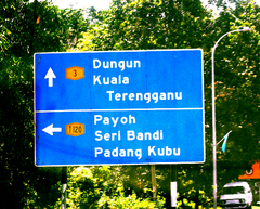
. For example Federal Route can also be written as Federal Route Both federal and state roads have blue road signs and the text colour is white.
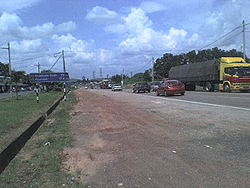
Most of the federal roads in Malaysia are 2-lane roads. Malaysia implements a right-hand driving system where drivers drive on the left side of the road. However, there are in certain places where additional lanes are available. In town areas, federal roads may become 4-lane roads to increase traffic capacity. In hilly areas, additional third climbing lane is available for slower vehicles such as buses and lorries.
Some federal roads may have motorcycle lane
Motorcycle lane
Motorcycle lane is a main term for special lane for small vehicles such as motorcycles, scooters, bicycles, trishaw and many more.- Malaysia :...
s. On Malaysian federal roads, the motorcycle lanes are placed at the extreme left side of each direction and only separated from the main lanes by black-and-white stripes to enable motorcyclists to overtake slower motorcycles and to turn right to exit the road.
Some expressways in Malaysia such as Federal Highway
Federal Highway, Malaysia
Federal Highway, or Lebuhraya Persekutuan in Malay is a Malaysian highway connecting the capital city of Kuala Lumpur, and Klang, Selangor. The highway starts from Seputeh in Kuala Lumpur to Klang, Selangor...
and Skudai Highway
Skudai Highway
Skudai Highway , also known as Senai Highway Jalan Tun Abdul Razak or Jalan Skudai, Federal route is a 29 kilometre partial-access highway in Johor, Malaysia, from the town of Senai to the Johor-Singapore Causeway, which connects Malaysia and...
are federally funded, therefore all federally funded expressways are also classified as federal roads.
Nearly all federal roads are paved with typical tarmac
Tarmac
Tarmac is a type of road surface. Tarmac refers to a material patented by Edgar Purnell Hooley in 1901...
except Skudai-Pontian Highway
Skudai-Pontian Highway
Skudai–Pontian Highway route is a highway that connects Skudai in the east with the town of Pontian Kechil in the west. It is also known as Jalan Pontian and Jalan Johor...
which is paved with concrete
Concrete
Concrete is a composite construction material, composed of cement and other cementitious materials such as fly ash and slag cement, aggregate , water and chemical admixtures.The word concrete comes from the Latin word...
from Universiti Teknologi Malaysia
Universiti Teknologi Malaysia
Universiti Teknologi Malaysia is the oldest public engineering and technological university in Malaysia. The university specialises in technical studies, with separate faculties for Education, Pure Sciences, Management, and Human Resources Development. It is the country's major source of graduate...
interchange to Taman Sri Pulai junction and Sitiawan-Batak Rabit road (Federal route ) from Sitiawan
Sitiawan
Sitiawan, Malaysia is a region in the Manjung district of Perak, Malaysia....
to Kota Setia
Kota Setia
Kota Setia is a small town in Hilir Perak district in Perak, Malaysia....
. Meanwhile at Federal Highway
Federal Highway, Malaysia
Federal Highway, or Lebuhraya Persekutuan in Malay is a Malaysian highway connecting the capital city of Kuala Lumpur, and Klang, Selangor. The highway starts from Seputeh in Kuala Lumpur to Klang, Selangor...
linking Klang to Kuala Lumpur, the section of the highway from Subang Jaya
Subang Jaya
Subang Jaya is a suburban city in the Klang Valley, Selangor, Malaysia. It comprises the southern third of the district of Petaling, and is home to a third of the district population of 1.78 million. Subang Jaya comprises , Bandar Sunway, UEP Subang Jaya, Putra Heights and Batu Tiga...
to Kota Darul Ehsan
Kota Darul Ehsan
Kota Darul Ehsan is a row of arches symbolizing the border on Malaysian Federal Highway between the Federal Territory of Kuala Lumpur and Malaysian state of Selangor...
near Petaling Jaya
Petaling Jaya
Petaling Jaya is a Malaysian city originally developed as a satellite township for Kuala Lumpur comprising mostly residential and some industrial areas. It is located in the Petaling district of Selangor with an area of approximately 97.2 km². On 20 June 2006, Petaling Jaya was granted a...
are paved with asphalt
Asphalt
Asphalt or , also known as bitumen, is a sticky, black and highly viscous liquid or semi-solid that is present in most crude petroleums and in some natural deposits, it is a substance classed as a pitch...
.
Sarawak has some of the most extensive federal road network in Malaysia. All federal roads in Sarawak is connecting main divisions with exception of Mukah division
Mukah Division
Mukah Division is one of the eleven administrative divisions in Sarawak, east Malaysia, on the island of Borneo. It was established on March 1, 2002 and it has a total area of 6,997.61 square kilometers....
. As for Kapit division
Kapit Division
Kapit Division, formed on April 2, 1973, is the seventh of eleven administrative divisions in Sarawak, east Malaysia, on the island of Borneo. It has a total area of 38,934 square kilometers, and is the largest of the administrative divisions of Sarawak....
, the only federal road serving this division is Jalan Bakun (starting from KM 95 - KM 120). Coastal road of Bintulu-Miri is a still in dispute between federal government and state government right of maintenance. It is due to the construction is federal funded, but the compensation and acquisition of land are from Sarawak state government. No federal roads are isolated from the network unlike state roads. Uniquely in Sarawak, federal road network is adjoined internationally to Brunei highway at Sungai Tujuh (Miri
Miri
Miri is a city in northern Sarawak, Malaysia, on the island of Borneo. It is the second largest city in Sarawak, with a population of about 300,000, and the government administrative centre of Miri District in Miri Division....
) with Kuala Belait
Kuala Belait
This article refers to the town of Kuala Belait. For the mukim of the same name, please refer to Kuala Belait, Belait. For district, please see Belait district.Kuala Belait |Jawi]]: )is a town located in South-West of Brunei...
(Brunei), Tedungan (Limbang
Limbang
Limbang is a border town and the capital of Limbang District in the Limbang Division of northern Sarawak, East Malaysia, on the island of Borneo. The division has an area of 3,978.1 square kilometers, and a population of 42,600...
) with Kuala Lurah (Brunei), Limbang with Puni (Brunei), Lawas
Lawas
border=1 align=right cellpadding=1 cellspacing=0 width=260 style="margin: 0 0 1em 1em; background: #f9f9f9; border: 1px #aaa solid; border-collapse: collapse; font-size: 95%;"|+Lawas...
with Labu (Brunei) and also to Indonesian road network at Tebedu (Serian
Serian
Serian may refer to:* Syrian , An Italian synthpop band* Syrian Jews* Syrian Wars, a series of six wars between the Seleucid Empire and the Ptolemaic Kingdom* Ephrem the SyrianIn places:* Serian, Punjab, a town in Punjab, Pakistan...
district) with Entikong (Kalimantan Barat, Indonesia
Indonesia
Indonesia , officially the Republic of Indonesia , is a country in Southeast Asia and Oceania. Indonesia is an archipelago comprising approximately 13,000 islands. It has 33 provinces with over 238 million people, and is the world's fourth most populous country. Indonesia is a republic, with an...
).
Malaysian federal roads are subject to the rural highway standard adopted by Malaysian Public Works Department
Malaysian Public Works Department
Malaysian Public Works Department ' or Jabatan Kerja Raya Malaysia ' is the federal government department in Malaysia under Malaysian Ministry of Works which is responsible for construction and maintenance of public infrastructure in Malaysia such as federal and state roads, public government...
(JKR), ranging from R1 and R1a (minor roads at villages and FELDA settlements with no access control and low speed limits) to R5 (federal roads or highways with limited access control and speed limits up to 90 km/h). R6 standard is exclusive for high-speed (up to 110 km/h) expressways
Controlled-access highway
A controlled-access highway is a highway designed exclusively for high-speed vehicular traffic, with all traffic flow and ingress/egress regulated...
with full access
Limited-access road
A limited-access road known by various terms worldwide, including limited-access highway, dual-carriageway and expressway, is a highway or arterial road for high-speed traffic which has many or most characteristics of a controlled-access highway , including limited or no access to adjacent...
control.
Type of federal roads and route number categories
| Examples | Information | Number digits |
|---|---|---|
| Main federal route numbers | 001 - 249 | |
| Institutional facilities federal roads | 250 - 479 | |
| Federal road exit numbers | EXIT 201 - EXIT 299 | |
| Main federal route numbers (Sarawak) |
1-1 - 1-59 3-1 - 3-99 |
|
| Main federal route numbers (Sabah; old numbering system) |
A01 - A99 | |
| Main federal route numbers (Labuan) |
700 - 799 | |
| FELDA/FELCRA federal route numbers | 1000 - 1999 2000 - 2999 |
|
| Industrial federal route numbers | 3000 - 3999 |
FELDA/FELCRA federal roads
Mostly found at FELDA and FELCRA settlements in Peninsula Malaysia only. The road was built by FELDA or FELCRA and JKR.In Sarawak, federal roads for FELDA is in Lundu and for SALCRA is in Sarikei.
Industrial federal roads
Mostly found at the industrial areas in Peninsula Malaysia only.In Sarawak, there are two industrial federal roads, which are located at Pending Industrial Estate in Kuching and Kidurong Industrial Estate in Bintulu.
Institutional facilities federal roads
Mostly found at the entrance to the federal institutional facilities such as universityUniversity
A university is an institution of higher education and research, which grants academic degrees in a variety of subjects. A university is an organisation that provides both undergraduate education and postgraduate education...
, military bases, satelite earth stations, airports, TV and radio frequency stations, telecom exchange stations, hospitals and tourist attractions.
- For more information, please refer to Road signs in Malaysia articlesRoad signs in MalaysiaRoad signs in Malaysia are standardized road signs similar to those used in other nations but with certada]], and Australia, alin distinctions. Until the early 1980s, Malaysia closely followed Australian and Japanese practice in road sign design, with diamond-shaped warning signs and circular...
or Malaysian Road Signs Information Brochure
Rural
| Standard | Max design speed limit (km/h) |
Minimum lane width (m Metre The metre , symbol m, is the base unit of length in the International System of Units . Originally intended to be one ten-millionth of the distance from the Earth's equator to the North Pole , its definition has been periodically refined to reflect growing knowledge of metrology... ) |
Access control | Application |
|---|---|---|---|---|
| JKR R6 | 120 | 3.5 | Full | Expressways Controlled-access highway A controlled-access highway is a highway designed exclusively for high-speed vehicular traffic, with all traffic flow and ingress/egress regulated... under the administration of Malaysian Highway Authority Malaysian Highway Authority The Malaysian Highway Authority or Lembaga Lebuhraya Malaysia is a government agency under the Malaysian Ministry of Works... (MHA) |
| JKR R5 | 100 | 3.5 | Partial | Primary roads and partial access highways for the Federal JKR |
| JKR R4 | 90 | 3.25 | Partial | Main / secondary roads |
| JKR R3 | 70 | 3.0 | Partial | Secondary roads |
| JKR R2 | 60 | 2.75 | None | Minor roads Note: JKR R2 is the minimum geometrical standard for 2-lane roads |
| JKR R1 | 40 | (5.0) |
None | Single-lane minor roads (country lane Country lane A country lane is a narrow road in the countryside.In North America and Australia, the term also may refer to rear access roads which act as a secondary vehicular network in cities and towns. Large cities in the US states of Nevada and Texas tend to apply the term to many arterial roads... ) |
| JKR R1a | 40 | (4.5) |
None | Single-lane roads (roads to restricted areas such as quarries) |
Urban
| Standard | Max design speed limit (km/h) |
Minimum lane width (m Metre The metre , symbol m, is the base unit of length in the International System of Units . Originally intended to be one ten-millionth of the distance from the Earth's equator to the North Pole , its definition has been periodically refined to reflect growing knowledge of metrology... ) |
Access control | Application |
|---|---|---|---|---|
| JKR U6 | 100 | 3.5 | Full | Expressways Controlled-access highway A controlled-access highway is a highway designed exclusively for high-speed vehicular traffic, with all traffic flow and ingress/egress regulated... under the administration of Malaysian Highway Authority Malaysian Highway Authority The Malaysian Highway Authority or Lembaga Lebuhraya Malaysia is a government agency under the Malaysian Ministry of Works... (MHA) |
| JKR U5 | 80 | 3.5 | Partial | Arterial roads and partial access municipal highways |
| JKR U4 | 70 | 3.25 | Partial | Arterial / collector roads |
| JKR U3 | 60 | 3.0 | Partial | Collector roads / Local streets |
| JKR U2 | 50 | 2.75 | None | Local streets Note: JKR U2 is the minimum geometrical standard for 2-lane roads |
| JKR U1 | 40 | (5.0) |
None | Single-lane street (in towns) |
| JKR U1a | 40 | (4.5) |
None | Single-lane street (as in low-cost housing areas) |
(Source: Arahan Teknik (Jalan) 8/86 - A Guide on Geometric Design of Roads, Jabatan Kerja Raya Malaysia)
Malaysian federal roads as a part of Asian Highway Network
Asian Highway NetworkAsian Highway Network
The Asian Highway project, also known as the Great Asian Highway, is a cooperative project among countries in Asia and Europe and the United Nations Economic and Social Commission for Asia and the Pacific , to improve the highway systems in Asia...
is an international project between Asian nations to develop their highway systems which will form the main routes in the Asian Highway network. There are 3 Asian Highway routes passing through Malaysia - Asian Highway Route 2
AH2
The AH2 is a road in the Asian Highway Network running 8230 miles from Denpasar, Indonesia to Khosravi, Iran. The route is as follows:-Indonesia:Denpasar — Surabaya — Surakarta — Semarang — Cikampek — Jakarta...
, Asian Highway Route 18
AH18
Asian Highway Route is a highway route included in Asian Highway Network, running from Haadyai in Thailand to Johor Bahru, Malaysia. Route runs along main eastern coastal road in southern Thailand and also along Federal Route of Malaysia.- Thailand :...
and Asian Highway Route 150 .
The Malaysian section of Route consists of:-
- North-South Expressway
- New Klang Valley ExpresswayNew Klang Valley ExpresswayThe New Klang Valley Expressway, or the NKVE refers to a stretch of the North-South Expressway in Peninsular Malaysia which starts from Bukit Raja near Klang town, and ends at Jalan Duta in Kuala Lumpur. It is a busiest expressway in Klang Valley during rush hour from/to Kuala Lumpur...
- North-South Expressway Central LinkNorth-South Expressway Central LinkNorth South Expressway Central Link, NSECL , also known as ELITE or ELITE Highway, is the main expressway in Malaysia. The of the expressway starts from Shah Alam Interchange until Nilai North Interchange...
- Federal Route 1Malaysia Federal Route 1Federal Route 1 is the first federal road in Malaysia, and among the oldest federal roads in Malaysia, having been constructed by the British government during colonial times...
- Skudai HighwaySkudai HighwaySkudai Highway , also known as Senai Highway Jalan Tun Abdul Razak or Jalan Skudai, Federal route is a 29 kilometre partial-access highway in Johor, Malaysia, from the town of Senai to the Johor-Singapore Causeway, which connects Malaysia and...
- Johor Causeway
The Malaysian section of Route consists of:-
- Federal Route 3Malaysia Federal Route 3Federal Route 3 is a main federal road on the east coast of Peninsula Malaysia. The roads connects Rantau Panjang in Kelantan until Johor Bahru in Johor...
- Sultan Mahmud Bridge HighwaySultan Mahmud Bridge HighwaySultan Mahmud Bridge Highway or Jalan Tengku Mizan, Federal route is a major highway in Kuala Terengganu, Terengganu, Malaysia.-List of interchanges:...
- Kuantan BypassKuantan BypassKuantan Bypass, Federal Route is a main highway bypass in Kuantan, Pahang, Malaysia. It was built on 1977 until it was completed on 1979.-Current developments:...
- Tebrau Highway
The Malaysian section of Route consists of:-
- Pan Borneo HighwayPan Borneo HighwayPan Borneo Highway , also known as Trans Borneo Highway, , ' is a network of federal roads connecting Sarawak, Brunei and Sabah. The Pan Borneo Highway project is a joint project between the governments of Brunei and Malaysia...
- Miri-Baram HighwayMiri-Baram HighwayMiri–Baram Highway, Federal Route , also known as Jalan Kuala Baram-Sungai Tujuh, is a major highway in Miri Division, Sarawak, Malaysia. This highway is part of the Pan Borneo Highway .- List of Interchanges :...
Federal road maintenances
Before early 2000, the Malaysian federal roads were maintained by the Public Works Department. Beginning in 2000, the main contractors and maintenance company have the responsibility to maintain all federal roads in Malaysia.| Regions | Company |
|---|---|
| Northern region | Belati Wangsa (M) Sdn Bhd |
| Central and east coast region | Roadcare (M) Sdn Bhd |
| Southern region | Selia Selenggara (M) Sdn Bhd; a subsidiary of the Ranhill Bersekutu (M) Sdn Bhd. Federal Route Malaysia Federal Route 1 Federal Route 1 is the first federal road in Malaysia, and among the oldest federal roads in Malaysia, having been constructed by the British government during colonial times... is made by Selia Selanggara (M) Sdn Bhd, Roadcare (M) Sdn Bhd and Ranhill Bersekutu (M) Sdn Bhd for Batu Pahat Batu Pahat Batu Pahat is a district in the state of Johor, Malaysia. It lies south-east of Muar, south-west of Kluang, north-west of Pontian, and south of Segamat and the new Ledang district. The capital of the district is Bandar Penggaram, Batu Pahat.... districts. |
| Sabah (including Federal Territory of Labuan) |
Pembinaan Kekal Mewah Sdn Bhd |
| Sarawak (Kuching, Samarahan, Sri Aman, Betong, Sarikei region) |
PPES Works Sdn. Bhd; a subsidiary of the Cahya Mata Sarawak Berhad Cahya Mata Sarawak Berhad Cahya Mata Sarawak Berhad , which literally means "the light of Sarawak's eye" in the Malay language or "Cahya Mata" also means "the child of", is a major company in Sarawak, Malaysia... (CMSB) Group |
| Sarawak (Sibu, Mukah, Bintulu region) |
HCM Engineering Sdn. Bhd.; a subsidiary of the Protasco Berhad |
| Sarawak (Miri, Limbang, Kapit region) |
Endaya Construction Sdn. Bhd.; a subsidiary of the Encorp Properties Sdn. Bhd. |
Speed limits
The default speed limitSpeed limit
Road speed limits are used in most countries to regulate the speed of road vehicles. Speed limits may define maximum , minimum or no speed limit and are normally indicated using a traffic sign...
and National Speed Limits
National Speed Limits
Had Laju Kebangsaan is a set of speed limits applicable on Malaysian expressways, federal roads, state roads and municipal roads. The National Speed Limits was enforced on 1 February 1989 following the National Speed Limit Orders 1989 ...
is 90 km/h (55 mph); however, a lower speed limit of 80 km/h (50 mph) has been implemented during festive seasons starting from the 2006 Hari Raya Aidilfitri as a preventive measure to reduce accidents during festive seasons. In town areas, the speed limit is reduced to 60 km/h (40 mph). Speed trap
Speed Trap
Speed Trap is a live jazz album by Peter King, recorded at Ronnie Scott's Jazz Club in September 1994, and released in 1996 under the Ronnie Scotts Jazz House label...
s are also deployed by the Malaysian police
Royal Malaysian Police
The Royal Malaysia Police is a part of the security forces structure in Malaysia. The force is a centralised organization with responsibilities ranging from traffic control to intelligence gathering. Its headquarters is located at Bukit Aman, Kuala Lumpur. The police force is led by an...
at many places along the federal roads.
Accidents
Malaysian federal roads are always sites of most of the road accidents in Malaysia, especially during festive seasons.List of accident-prone areas in Malaysian federal roads
- km of Skudai-Pontian HighwaySkudai-Pontian HighwaySkudai–Pontian Highway route is a highway that connects Skudai in the east with the town of Pontian Kechil in the west. It is also known as Jalan Pontian and Jalan Johor...
between Kangkar Pulai and Pekan Nenas. - km of Skudai-Pontian HighwaySkudai-Pontian HighwaySkudai–Pontian Highway route is a highway that connects Skudai in the east with the town of Pontian Kechil in the west. It is also known as Jalan Pontian and Jalan Johor...
near Pekan Nenas. - km 25 ~ 34 of Muar-Segamat Road near Kebun Bahru / Serom estate
- km 13 - 16 of Seremban-Kuala Pilah Road near Bukit Putus
- km of Muar-Parit Sulong Road near Bukit Mor
- km of along Pasir Gudang HighwayPasir Gudang HighwayPasir Gudang Highway, also known as Federal Route is a major highway or large road in Johor, Malaysia that connects Tampoi North in the west to Pasir Gudang, Johor Port and Tanjung Langsat in the east. Pasir Gudang Highway is a four-laned highway, unlike the wider Skudai Highway which has six lanes...
- km of Kota Tinggi-Ulu Tiram Road
- km of Gua Musang Highway between Kuala LipisKuala LipisKuala Lipis is a big town in Pahang, Malaysia with a population of 200,000. It is located in the district of Lipis.-History:Kuala Lipis was a gold-mining center before the British arrived in 1887. In 1898 it became the capital of Pahang until 1953....
-Gua MusangGua MusangGua Musang is a town and territory in Kelantan, Malaysia. It is the largest district in Kelantan. Gua Musang is administered by the Gua Musang District Council. Gua Musang district is bordered by the state of Pahang to the south, Terengganu to the east, Perak to the west and the Kelantanese...
near MerapohMerapohMerapoh is a small town situated in the Lipis district of Pahang, Malaysia. Located near Pahang-Kelantan border.Jalan Bukit Tujuh is an infamous short strip of road along the route from Merapoh in the state of Pahang to Gua Musang in the state of Kelantan. The strip which is in the state of...
- km of Gua Musang Highway between Kuala KraiKuala KraiKuala Krai is a territory and town in the interior of the State of Kelantan in the north-east of Malaysia.-Kuala Krai territory:...
-Gua MusangGua MusangGua Musang is a town and territory in Kelantan, Malaysia. It is the largest district in Kelantan. Gua Musang is administered by the Gua Musang District Council. Gua Musang district is bordered by the state of Pahang to the south, Terengganu to the east, Perak to the west and the Kelantanese...
- km of Jemaluang-Kota Tinggi Road
- km of Karak-Temerloh Road
- km of Temerloh-Maran Road between route (Jengka) and Lubuk Paku junctions
- km of Maran-Gambang Road
- km of Muar-Melaka Road near Tiang Dua, Bemban junctions
- km of Melaka-Masjid Tanah Road
- km of along Tun Razak HighwayTun Razak HighwayTun Razak Highway, Federal Route , or also known as Segamat-Kuantan Highway is a federal highway running from the town of Segamat, Johor to Gambang before proceeding another via Federal route to Gambang near Kuantan, Pahang...
- km of Mantin-Seremban Road
- km of Temerloh-Gemas Road near Teriang estate
- km of Seremban-Port Dickson Road
- km 18 ~ 22 of Asam Jawa-Sungai Buloh Road
- km of Second East-West HighwaySecond East-West HighwaySecond East-West Highway, Federal Route is a highway in Peninsular Malaysia which connects Simpang Pulai in Perak to Gua Musang in Kelantan. The highway is expected to be extended further east to Kuala Terengganu in the future. This highway features a four-lane carriageway from Simpang Pulai to...
- km of Tapah-Cameron Highlands Road
- km of Kulai-Kota Tinggi Road
- km of Pengerang HighwayMalaysia Federal Route 92Federal Route 92 , also known as Pengerang Highway is a federal highway that runs from Kota Tinggi to Sungai Rengit in Johor. It is also a main route to Desaru beach...
- km of Genting Sempah-Genting Highlands HighwayGenting Sempah-Genting Highlands HighwayThe Genting Sempah-Genting Highlands Highway, Federal Route is a main highway from Genting Sempah to Genting Highlands, Malaysia's famous mountain resort and entertainment parks.-History:...
- km of North Klang Straits BypassNorth Klang Straits BypassNorth Klang Straits Bypass, Federal Route is the main highway bypass to Port Klang in Klang, Selangor, Malaysia. Federal Route 20 became the backbone of the road system linking Sungai Rasau to Port Klang before being surpassed by the New North Klang Straits Bypass...
- km of Benta-Jerantut Road
- km of Raub-Benta Road
- km of Benta-Kuala Lipis Road
- km of Bukit Fraser Road
- km of Second East-West HighwaySecond East-West HighwaySecond East-West Highway, Federal Route is a highway in Peninsular Malaysia which connects Simpang Pulai in Perak to Gua Musang in Kelantan. The highway is expected to be extended further east to Kuala Terengganu in the future. This highway features a four-lane carriageway from Simpang Pulai to...
near Perak-Pahang border - km of Gua Musang-Kuala KraiKuala KraiKuala Krai is a territory and town in the interior of the State of Kelantan in the north-east of Malaysia.-Kuala Krai territory:...
Road - km of Seremban-Kuala Pilah Road between Paroi and Ulu Bendul (Bukit Putus section)
- km of Seremban-Kuala Klawang Road
- km of Serian-Sri Aman Road , at Bukit Begunan, Sri Aman, Sarawak
- km of Bintulu-Sibu Road , near Bintulu airport junction, Bintulu, Sarawak
- km of Labu-Lawas Road , just after Lawas Immigration Complex, Lawas, Sarawak (extreme road slope condition)
During festive seasons
During festive seasons such as Chinese New YearChinese New Year
Chinese New Year – often called Chinese Lunar New Year although it actually is lunisolar – is the most important of the traditional Chinese holidays. It is an all East and South-East-Asia celebration...
, Deepavali, Christmas
Christmas
Christmas or Christmas Day is an annual holiday generally celebrated on December 25 by billions of people around the world. It is a Christian feast that commemorates the birth of Jesus Christ, liturgically closing the Advent season and initiating the season of Christmastide, which lasts twelve days...
and Hari Raya Aidilfitri, activities such as construction, road repairs and maintenance works have been stopped. Meanwhile a heavy goods vehicles such as logging truck, cement truck, container truck, construction materials truck and other heavy goods vehicles (except tanker lorry, provision goods truck, crane, tow truck, fire engine, ambulance etc.) are banned from using roads, highways and expressways during festive seasons. A massive nationwide operation known as Ops Sikap
Ops Sikap
Ops Sikap is a traffic safety operation carried out by the Royal Malaysian Police to ensure safety on all roads in Malaysia during festive seasons such as Hari Raya Aidilfitri, Deepavali, Christmas Day and Chinese New Year...
are held annually by the Malaysian police
Royal Malaysian Police
The Royal Malaysia Police is a part of the security forces structure in Malaysia. The force is a centralised organization with responsibilities ranging from traffic control to intelligence gathering. Its headquarters is located at Bukit Aman, Kuala Lumpur. The police force is led by an...
to ensure safety on all roads in Malaysia during festive seasons.
Natural hazards
The Public Works DepartmentMalaysian Public Works Department
Malaysian Public Works Department ' or Jabatan Kerja Raya Malaysia ' is the federal government department in Malaysia under Malaysian Ministry of Works which is responsible for construction and maintenance of public infrastructure in Malaysia such as federal and state roads, public government...
has monitored all federal roads in Malaysia and make sure that no landslides, flash floods and other natural hazards may happen again.
List of landslide-prone areas
- km of along East-West HighwayEast-West Highway (Malaysia)East-West Highway, Federal Route is a highway constructed by Malaysian Public Works Department to shorten the journey from Kota Bharu, Kelantan to northwestern towns and cities of Malaysia such as Alor Star and Penang...
- km of Parit Sulong-Parit Yaani between Tongkang PechahTongkang PechahTongkang Pechah(中江)is a small town in Johor, Malaysia. Its name was taken from the bauxite ore tongkang which sunk in Sungai Simpang Kiri...
and Sri MedanSri MedanSri Medan(铁山)is a main town in Johor, Malaysia. Long ago, it was a famous bauxite mine in Johore.-External links:*...
junctions - km of Maran-Gambang Road
- km of Mantin-Seremban Road
- km of Changkat Jering-Kuala Kangsar Road near Bukit Berapit
- km 13 - 16 of Seremban-Kuala Pilah Road near Bukit Putus
- km of Tapah-Cameron Highlands Road
- km of Genting Sempah-Bentong Road
- km of Gombak-Genting Sempah Road
- km of Genting Sempah-Genting Highlands HighwayGenting Sempah-Genting Highlands HighwayThe Genting Sempah-Genting Highlands Highway, Federal Route is a main highway from Genting Sempah to Genting Highlands, Malaysia's famous mountain resort and entertainment parks.-History:...
- km of Bukit Fraser Road
- km of Ulu Tiram-Kota Tinggi Road
- km of Tatau-Bintulu Road
List of flash floods-prone areas
- km 15 of Federal HighwayFederal Highway, MalaysiaFederal Highway, or Lebuhraya Persekutuan in Malay is a Malaysian highway connecting the capital city of Kuala Lumpur, and Klang, Selangor. The highway starts from Seputeh in Kuala Lumpur to Klang, Selangor...
at Batu TigaBatu TigaBatu Tiga is a township in Subang Jaya, Selangor, Malaysia. It is located at the border between Subang Jaya and Shah Alam. However, it is nearer to Shah Alam than the city centre of Subang Jaya...
, Shah AlamShah AlamShah Alam is the state capital of Selangor, Malaysia situated within the Petaling District and a small portion of the neighboring Klang District. It is located about west of the country's capital, Kuala Lumpur. Shah Alam replaced Kuala Lumpur as the capital city of the state of Selangor in 1978...
, SelangorSelangorSelangor also known by its Arabic honorific, Darul Ehsan, or "Abode of Sincerity") is one of the 13 states of Malaysia. It is on the west coast of Peninsular Malaysia and is bordered by Perak to the north, Pahang to the east, Negeri Sembilan to the south and the Strait of Malacca to the west... - km of Jerangau Highway , TerengganuTerengganuTerengganu is a sultanate and constitutive state of federal Malaysia. The state is also known by its Arabic honorific, Darul Iman...
- km of Gua Musang Highway from Kuala KraiKuala KraiKuala Krai is a territory and town in the interior of the State of Kelantan in the north-east of Malaysia.-Kuala Krai territory:...
to Kota BharuKota BharuKota Bharu is a city in Malaysia, is the state capital and Royal City of Kelantan. It is also the name of the territory in which Kota Bharu City is situated. The name means 'new city' or 'new castle/fort' in Malay. Kota Bharu is situated in the northeastern part of Peninsular Malaysia, and lies...
, KelantanKelantanKelantan is a state of Malaysia. The capital and royal seat is Kota Bharu. The Arabic honorific of the state is Darul Naim, ....
. - km of federal routeMalaysia Federal Route 4Federal Route 4 is a federal road in the north of Peninsula Malaysia. The roads connects Gerik, Perak until Pasir Puteh in Kelantan.- Route background :...
from JeliJeliJeli is a town and territory in Kelantan, Malaysia. As of 2000, the district's population is estimated to be 42,882. Jeli is administered by the Jeli District Council. Jeli is bordered by the state of Perak to the west, Thailand to the north, Tanah Merah district to the north east and Kuala Krai...
to Pasir PutehPasir PutehPasir Puteh is a territory and town in Kelantan, Malaysia. The town of Pasir Putih is situated on the bank of Semerak River, about 30 kilometers to the south of Kota Bharu.-History:...
, KelantanKelantanKelantan is a state of Malaysia. The capital and royal seat is Kota Bharu. The Arabic honorific of the state is Darul Naim, ....
. - km of Pasir Gudang HighwayPasir Gudang HighwayPasir Gudang Highway, also known as Federal Route is a major highway or large road in Johor, Malaysia that connects Tampoi North in the west to Pasir Gudang, Johor Port and Tanjung Langsat in the east. Pasir Gudang Highway is a four-laned highway, unlike the wider Skudai Highway which has six lanes...
at Kempas Interchange, Johor BahruJohor BahruJohor Bahru is the capital city of Johor in southern Malaysia. Johor Bahru is the southernmost city of the Eurasian mainland...
, JohorJohorJohor is a Malaysian state, located in the southern portion of Peninsular Malaysia. It is one of the most developed states in Malaysia. The state capital city and royal city of Johor is Johor Bahru, formerly known as Tanjung Puteri... - km of federal routeMalaysia Federal Route 1Federal Route 1 is the first federal road in Malaysia, and among the oldest federal roads in Malaysia, having been constructed by the British government during colonial times...
from SegamatSegamatSegamat is a town and district located in the north of the state of Johor in Malaysia, bordering two other states of Malaysia . It is located roughly 172 kilometres from Johor Bahru, the capital city of Johor State. It is 95 km travel distance via North-South Expressway from Johor Bahru to...
to Yong PengYong PengYong Peng is a regional town in Malaysia in the state of Johor. It has an area of 1911.6 hectares with an estimated population of 29,046. Yong Peng has two main interchanges on North-South Expressway including north to Kuala Lumpur and south to Johor Bahru.... - km of federal routeMalaysia Federal Route 1Federal Route 1 is the first federal road in Malaysia, and among the oldest federal roads in Malaysia, having been constructed by the British government during colonial times...
from Yong PengYong PengYong Peng is a regional town in Malaysia in the state of Johor. It has an area of 1911.6 hectares with an estimated population of 29,046. Yong Peng has two main interchanges on North-South Expressway including north to Kuala Lumpur and south to Johor Bahru....
to Ayer HitamAyer HitamAyer Hitam is a rest town in Johor, Malaysia. Located just at the junction of route and route , it is known for its many outlets selling pottery and other crafts. It also is one of the interchange for North-South Expressway. It is the border town between Batu Pahat and Kluang district... - km of federal routeMalaysia Federal Route 50Federal Route 50 is a federal road in Johor, Malaysia. The roads connects Batu Pahat in the west to Jemaluang in the east.-Route background:...
from Batu PahatBatu PahatBatu Pahat is a district in the state of Johor, Malaysia. It lies south-east of Muar, south-west of Kluang, north-west of Pontian, and south of Segamat and the new Ledang district. The capital of the district is Bandar Penggaram, Batu Pahat....
to KluangKluangKluang is a town and district located roughly in the middle of the state of Johor in Malaysia. Kluang lies about 110 km north of Johor Bahru, east-southeast of Batu Pahat, west of Mersing and south of Segamat... - km of federal routeMalaysia Federal Route 50Federal Route 50 is a federal road in Johor, Malaysia. The roads connects Batu Pahat in the west to Jemaluang in the east.-Route background:...
from KluangKluangKluang is a town and district located roughly in the middle of the state of Johor in Malaysia. Kluang lies about 110 km north of Johor Bahru, east-southeast of Batu Pahat, west of Mersing and south of Segamat...
to MersingMersingMersing is a town in Mersing District in the northeast corner of the state of Johor, Malaysia.Mersing town is a lively tourist town visited by Malaysians and foreign tourists.... - km of federal routeMalaysia Federal Route 23Federal Route 23 is a federal road in Johor, Malaysia, connecting Segamat in the north and Parit Bunga in the south. The roads is also a main route to North-South Expressway Southern Route via Tangkak Interchange.-Route background:...
from Parit BungaParit BungaParit Bunga is a small town in Muar, Johor, Malaysia. It is located on the Muar River and on the intersection between the roads to Malacca and Tangkak....
to Sungai MatiSungai MatiSungai Mati is a small town in the state of Johor, Malaysia. It is situated between the towns of Tangkak and Muar.Sungai Mati was named in such a way is due to its nature of being an ox-bow lake. It formed or breakaway from main river of Muar River. The "breakaway" cause by a massive flood in...
, MuarMuar (town)Muar, also known as Bandar Maharani is a town geopolitically situated in Muar District in the region or area of Muar in northwestern Johor, Malaysia...
, JohorJohorJohor is a Malaysian state, located in the southern portion of Peninsular Malaysia. It is one of the most developed states in Malaysia. The state capital city and royal city of Johor is Johor Bahru, formerly known as Tanjung Puteri... - km of federal routeMalaysia Federal Route 24Federal Route 24 is a federal road in Johor, Malaysia. The roads connects Muar in the west to Yong Peng in the east.-Route background:The Kilometre Zero of the Federal Route 24 is located at Bulatan Bentayan roundabout in Muar, at its interchange with the Federal Route , the main trunk road of the...
from Parit SulongParit SulongParit Sulong is a small town in Johor, Malaysia on the Simpang Kiri River, 30 km east of Muar. The historical Parit Sulong Bridge constructed during World War II is a main feature in that town....
to Parit YaaniParit YaaniParit Yaani(巴力亚尼)is a small town in Johor, Malaysia. It is located within the parliamentary constituency of Sri Gading.... - km of federal routeMalaysia Federal Route 5Federal Route 5 is a main federal road on the west coast of Peninsula Malaysia. The roads connecting Ipoh, Perak in the north until Skudai, Johor in the south.-Route background:...
from MuarMuar (town)Muar, also known as Bandar Maharani is a town geopolitically situated in Muar District in the region or area of Muar in northwestern Johor, Malaysia...
to Batu PahatBatu PahatBatu Pahat is a district in the state of Johor, Malaysia. It lies south-east of Muar, south-west of Kluang, north-west of Pontian, and south of Segamat and the new Ledang district. The capital of the district is Bandar Penggaram, Batu Pahat.... - km of federal routeMalaysia Federal Route 5Federal Route 5 is a main federal road on the west coast of Peninsula Malaysia. The roads connecting Ipoh, Perak in the north until Skudai, Johor in the south.-Route background:...
from MerlimauMerlimauMerlimau is a town in Malacca, Malaysia. It is situated about 22 kilometers south-east of Melaka Historical City. Until 40 years ago, it used to be the main town travelers passed when traveling south of West Malaysia. Since then it was left out until more shophouses were constructed. Merlimau is...
, Melaka to Parit BungaParit BungaParit Bunga is a small town in Muar, Johor, Malaysia. It is located on the Muar River and on the intersection between the roads to Malacca and Tangkak....
, MuarMuar (town)Muar, also known as Bandar Maharani is a town geopolitically situated in Muar District in the region or area of Muar in northwestern Johor, Malaysia...
, JohorJohorJohor is a Malaysian state, located in the southern portion of Peninsular Malaysia. It is one of the most developed states in Malaysia. The state capital city and royal city of Johor is Johor Bahru, formerly known as Tanjung Puteri...
near Sungai RambaiSungai RambaiSungai Rambai is a small town in Malacca, one of the states of Malaysia. It is situated about 32 kilometers south of Malacca Town along the federal route to Muar. It is the last town in Malacca before crossing Kesang River into Johor. Sungai Rambai Recreational Park is nearby.-References:...
and KesangKesangKesang is a suburb of Muar, Johor, Malaysia. It lies on the border of the states of Johor and Melaka.... - km of federal routeMalaysia Federal Route 3Federal Route 3 is a main federal road on the east coast of Peninsula Malaysia. The roads connects Rantau Panjang in Kelantan until Johor Bahru in Johor...
from PekanPekanLocated on the banks of the Pahang River 50 km south of Kuantan, Pekan is the royal town of the Malaysian state of Pahang Darul Makmur. Its name comes from a flower, the Bunga Pekan. Pekan is also the name of the district the town is situated in, and a parliamentary constituency in its own right...
to Bandar Baru Rompin, PahangPahangPahang is the third largest state in Malaysia, after Sarawak and Sabah, occupying the huge Pahang River river basin. It is bordered to the north by Kelantan, to the west by Perak, Selangor, Negeri Sembilan, to the south by Johor and to the east by Terengganu and the South China Sea.Its state...
. - km of federal routeMalaysia Federal Route 3Federal Route 3 is a main federal road on the east coast of Peninsula Malaysia. The roads connects Rantau Panjang in Kelantan until Johor Bahru in Johor...
from Bandar Baru Rompin, PahangPahangPahang is the third largest state in Malaysia, after Sarawak and Sabah, occupying the huge Pahang River river basin. It is bordered to the north by Kelantan, to the west by Perak, Selangor, Negeri Sembilan, to the south by Johor and to the east by Terengganu and the South China Sea.Its state...
to EndauEndauEndau is a small town in Malaysia. It lies on the northern tip of east Johor and the southern tip of Pahang. It is famous as one of the largest fishing ports on the East Coast of Peninsular Malaysia.Located north of Mersing...
, JohorJohorJohor is a Malaysian state, located in the southern portion of Peninsular Malaysia. It is one of the most developed states in Malaysia. The state capital city and royal city of Johor is Johor Bahru, formerly known as Tanjung Puteri...
. - km of federal routeMalaysia Federal Route 3Federal Route 3 is a main federal road on the east coast of Peninsula Malaysia. The roads connects Rantau Panjang in Kelantan until Johor Bahru in Johor...
from EndauEndauEndau is a small town in Malaysia. It lies on the northern tip of east Johor and the southern tip of Pahang. It is famous as one of the largest fishing ports on the East Coast of Peninsular Malaysia.Located north of Mersing...
to MersingMersingMersing is a town in Mersing District in the northeast corner of the state of Johor, Malaysia.Mersing town is a lively tourist town visited by Malaysians and foreign tourists....
, JohorJohorJohor is a Malaysian state, located in the southern portion of Peninsular Malaysia. It is one of the most developed states in Malaysia. The state capital city and royal city of Johor is Johor Bahru, formerly known as Tanjung Puteri...
. - km of federal routeMalaysia Federal Route 3Federal Route 3 is a main federal road on the east coast of Peninsula Malaysia. The roads connects Rantau Panjang in Kelantan until Johor Bahru in Johor...
from Kota TinggiKota TinggiKota Tinggi is a town in the state of Johor of Malaysia, located around 42 kilometers north-east of Johor Bahru, on the road to Mersing. Hometown of Azizul Hanipah. Kota Tinggi can also be reached by ferry from Changi terminal in Singapore where tourists need to pass through the immigration check...
to MersingMersingMersing is a town in Mersing District in the northeast corner of the state of Johor, Malaysia.Mersing town is a lively tourist town visited by Malaysians and foreign tourists....
, JohorJohorJohor is a Malaysian state, located in the southern portion of Peninsular Malaysia. It is one of the most developed states in Malaysia. The state capital city and royal city of Johor is Johor Bahru, formerly known as Tanjung Puteri...
. - km of federal routeMalaysia Federal Route 3Federal Route 3 is a main federal road on the east coast of Peninsula Malaysia. The roads connects Rantau Panjang in Kelantan until Johor Bahru in Johor...
at Kota TinggiKota TinggiKota Tinggi is a town in the state of Johor of Malaysia, located around 42 kilometers north-east of Johor Bahru, on the road to Mersing. Hometown of Azizul Hanipah. Kota Tinggi can also be reached by ferry from Changi terminal in Singapore where tourists need to pass through the immigration check...
, JohorJohorJohor is a Malaysian state, located in the southern portion of Peninsular Malaysia. It is one of the most developed states in Malaysia. The state capital city and royal city of Johor is Johor Bahru, formerly known as Tanjung Puteri... - km of federal routeMalaysia Federal Route 91Federal Route 91 or Jalan Kluang-Kota Tinggi is the main federal roads in Johor, Malaysia connects Kluang to Kota Tinggi.-Notable features:...
at Kota TinggiKota TinggiKota Tinggi is a town in the state of Johor of Malaysia, located around 42 kilometers north-east of Johor Bahru, on the road to Mersing. Hometown of Azizul Hanipah. Kota Tinggi can also be reached by ferry from Changi terminal in Singapore where tourists need to pass through the immigration check...
, JohorJohorJohor is a Malaysian state, located in the southern portion of Peninsular Malaysia. It is one of the most developed states in Malaysia. The state capital city and royal city of Johor is Johor Bahru, formerly known as Tanjung Puteri... - km of federal routeMalaysia Federal Route 94Federal Route 94 or Jalan Kulai-Kota Tinggi is the main federal roads in Johor, Malaysia connects Kulai to Kota Tinggi.-Route background:...
from KulaiKulaiKulai , is a town in the Kulaijaya district of Johor, Malaysia. The town is 29 km from Johor Bahru city and 8 km from Skudai.-Administration:...
to Kota TinggiKota TinggiKota Tinggi is a town in the state of Johor of Malaysia, located around 42 kilometers north-east of Johor Bahru, on the road to Mersing. Hometown of Azizul Hanipah. Kota Tinggi can also be reached by ferry from Changi terminal in Singapore where tourists need to pass through the immigration check...
, JohorJohorJohor is a Malaysian state, located in the southern portion of Peninsular Malaysia. It is one of the most developed states in Malaysia. The state capital city and royal city of Johor is Johor Bahru, formerly known as Tanjung Puteri...
. - km of federal routeMalaysia Federal Route 1Federal Route 1 is the first federal road in Malaysia, and among the oldest federal roads in Malaysia, having been constructed by the British government during colonial times...
from BintuluBintuluBintulu is a coastal town, and the capital of Bintulu District in the Bintulu Division of Sarawak, Malaysia. It is about 650 kilometers from Kuching and about 215 kilometers from either Sibu or Miri....
to MiriMiriMiri is a city in northern Sarawak, Malaysia, on the island of Borneo. It is the second largest city in Sarawak, with a population of about 300,000, and the government administrative centre of Miri District in Miri Division....
, near Lambir National Park, Miri, Sarawak.
Facilities on the Malaysian federal roads
- Rest and Service Area and Restaurant and Rest PlazaRest areaA rest area, travel plaza, rest stop, or service area is a public facility, located next to a large thoroughfare such as a highway, expressway, or freeway at which drivers and passengers can rest, eat, or refuel without exiting on to secondary roads...
- These facilities can be found at all federal roads such as Batak RabitBatak RabitBatak Rabit is a small town in Hilir Perak district in Perak, Malaysia. The town is located near Teluk Intan town. It was named after Batak mercenaries that comes from the Batak District in Sumatra that was brought by Raja Laut during a Selangor civil war had their ears and noses grossly bangled...
, TemerlohTemerlohTemerloh is a town in Central Pahang, Malaysia in Temerloh district. Located about from Kuala Lumpur along the Kuantan-Kuala Lumpur trunk road, Temerloh is the second largest town in Pahang after Kuantan. It is situated at the junction of the Pahang River and the Semantan River...
and MersingMersingMersing is a town in Mersing District in the northeast corner of the state of Johor, Malaysia.Mersing town is a lively tourist town visited by Malaysians and foreign tourists....
. - U-turn - These U-turns can be found at the dual carriageway road.
- JKR Road Complaint HotlineMalaysian Public Works DepartmentMalaysian Public Works Department ' or Jabatan Kerja Raya Malaysia ' is the federal government department in Malaysia under Malaysian Ministry of Works which is responsible for construction and maintenance of public infrastructure in Malaysia such as federal and state roads, public government...
- These services can be found at all signboards along federal roads. - Road Transport Department (JPJ) Enforcement StationsMalaysian Road Transport DepartmentThe Malaysian Road Transport Department ' ' is a government department under the Malaysian Ministry of Transport...
- These stations can be found at all federal roads. These JPJ enforcement stations have weighing bridges to detect heavy vehicles. - Police Watch Tower - These towers can be found at all federal roads in Malaysia to monitored traffic situations during festive seasons.
- Pedestrian bridge - These bridge can be found at schools, institutional facilities and towns.
- Traffic lights - These yellow light can be found at the junctions and intersections.
- Warning lights - These yellow light can be found at the hazardous and accident areas.
- Automated Enforcement System (AES) - These systems can be found at accident-prone areas and the red-light camera at traffic light junctions.
Interesting facts
- The Pan Borneo HighwayPan Borneo HighwayPan Borneo Highway , also known as Trans Borneo Highway, , ' is a network of federal roads connecting Sarawak, Brunei and Sabah. The Pan Borneo Highway project is a joint project between the governments of Brunei and Malaysia...
is the longest federal road system in Malaysia, with the total length of 1047.18 km (length measured from Sematan, KuchingKuchingKuching , officially the City of Kuching, and formerly the City of Sarawak, is the capital and most populous city of the East Malaysian state of Sarawak. It is the largest city on the island of Borneo, and the fourth largest city in Malaysia....
to Sungai Tujuh, MiriMiriMiri is a city in northern Sarawak, Malaysia, on the island of Borneo. It is the second largest city in Sarawak, with a population of about 300,000, and the government administrative centre of Miri District in Miri Division....
). If measured from Sematan (SarawakSarawakSarawak is one of two Malaysian states on the island of Borneo. Known as Bumi Kenyalang , Sarawak is situated on the north-west of the island. It is the largest state in Malaysia followed by Sabah, the second largest state located to the North- East.The administrative capital is Kuching, which...
) to Serudong (SabahSabahSabah is one of 13 member states of Malaysia. It is located on the northern portion of the island of Borneo. It is the second largest state in the country after Sarawak, which it borders on its southwest. It also shares a border with the province of East Kalimantan of Indonesia in the south...
), the total length is estimated to be 1900 km (excluding BruneiBruneiBrunei , officially the State of Brunei Darussalam or the Nation of Brunei, the Abode of Peace , is a sovereign state located on the north coast of the island of Borneo, in Southeast Asia...
stretch of Pan Borneo Highway). - Federal Route , , , , and route were a main route for Japanese Imperial forcesImperial Japanese Army-Foundation:During the Meiji Restoration, the military forces loyal to the Emperor were samurai drawn primarily from the loyalist feudal domains of Satsuma and Chōshū...
from ThailandThailandThailand , officially the Kingdom of Thailand , formerly known as Siam , is a country located at the centre of the Indochina peninsula and Southeast Asia. It is bordered to the north by Burma and Laos, to the east by Laos and Cambodia, to the south by the Gulf of Thailand and Malaysia, and to the...
to SingaporeSingaporeSingapore , officially the Republic of Singapore, is a Southeast Asian city-state off the southern tip of the Malay Peninsula, north of the equator. An island country made up of 63 islands, it is separated from Malaysia by the Straits of Johor to its north and from Indonesia's Riau Islands by the...
during the Battle of MalayaBattle of MalayaThe Malayan Campaign was a campaign fought by Allied and Japanese forces in Malaya, from 8 December 1941 – 31 January 1942 during the Second World War. The campaign was dominated by land battles between British Commonwealth army units, and the Imperial Japanese Army...
between 1941 and 1942. There are many abandoned WWII-era bunkers along the roads. - The Federal RouteMalaysia Federal Route 1Federal Route 1 is the first federal road in Malaysia, and among the oldest federal roads in Malaysia, having been constructed by the British government during colonial times...
is the earliest federal road in Malaysia and also the longest federal road in Peninsular MalaysiaPeninsular MalaysiaPeninsular Malaysia , also known as West Malaysia , is the part of Malaysia which lies on the Malay Peninsula. Its area is . It shares a land border with Thailand in the north. To the south is the island of Singapore. Across the Strait of Malacca to the west lies the island of Sumatra...
. It must not be mistaken with Sarawak Federal Route which is also labelled as no.1, with same signage. - The slip roads of Persiaran Raja Muda MusaPersiaran Raja Muda MusaPersiaran Raja Muda Musa, Federal Route and is a major highway in Klang, Selangor, Malaysia. It connects Klang to Port Klang. It is also a main route to Port Klang...
(Route ), labeled as and , are the only slip roads designated as federal roads. - Jalan Gunung BrinchangJalan Gunung BrinchangJalan Gunung Brinchang, Federal Route is a federal roads in Cameron Highlands, Pahang, Malaysia. It is the highest paved road in Malaysia.-Notable features:...
route is the highest federal road and also the highest motorable road in Malaysia. - Jalan Sitiawan-Batak Rabit and Skudai-Pontian HighwaySkudai-Pontian HighwaySkudai–Pontian Highway route is a highway that connects Skudai in the east with the town of Pontian Kechil in the west. It is also known as Jalan Pontian and Jalan Johor...
(both in Federal RouteMalaysia Federal Route 5Federal Route 5 is a main federal road on the west coast of Peninsula Malaysia. The roads connecting Ipoh, Perak in the north until Skudai, Johor in the south.-Route background:...
are the only federal roads paved with concreteConcreteConcrete is a composite construction material, composed of cement and other cementitious materials such as fly ash and slag cement, aggregate , water and chemical admixtures.The word concrete comes from the Latin word...
. Meanwhile, the section of Federal HighwayFederal Highway, MalaysiaFederal Highway, or Lebuhraya Persekutuan in Malay is a Malaysian highway connecting the capital city of Kuala Lumpur, and Klang, Selangor. The highway starts from Seputeh in Kuala Lumpur to Klang, Selangor...
Route from Subang JayaSubang JayaSubang Jaya is a suburban city in the Klang Valley, Selangor, Malaysia. It comprises the southern third of the district of Petaling, and is home to a third of the district population of 1.78 million. Subang Jaya comprises , Bandar Sunway, UEP Subang Jaya, Putra Heights and Batu Tiga...
to Kota Darul EhsanKota Darul EhsanKota Darul Ehsan is a row of arches symbolizing the border on Malaysian Federal Highway between the Federal Territory of Kuala Lumpur and Malaysian state of Selangor...
is paved with asphaltAsphaltAsphalt or , also known as bitumen, is a sticky, black and highly viscous liquid or semi-solid that is present in most crude petroleums and in some natural deposits, it is a substance classed as a pitch...
. - Putrajaya-Cyberjaya ExpresswayPutrajaya-Cyberjaya ExpresswayPutrajaya-Cyberjaya Expressway, Federal Route is a major expressway in Klang Valley, Malaysia and become the first future federal highway on Multimedia Super Corridor...
route is the first future federal highway on Multimedia Super Corridor (MSC). - The biggest cloverleaf federal highway interchange in Malaysia is Bulatan Darul Ehsan of Federal HighwayFederal Highway, MalaysiaFederal Highway, or Lebuhraya Persekutuan in Malay is a Malaysian highway connecting the capital city of Kuala Lumpur, and Klang, Selangor. The highway starts from Seputeh in Kuala Lumpur to Klang, Selangor...
route in Shah AlamShah AlamShah Alam is the state capital of Selangor, Malaysia situated within the Petaling District and a small portion of the neighboring Klang District. It is located about west of the country's capital, Kuala Lumpur. Shah Alam replaced Kuala Lumpur as the capital city of the state of Selangor in 1978...
, SelangorSelangorSelangor also known by its Arabic honorific, Darul Ehsan, or "Abode of Sincerity") is one of the 13 states of Malaysia. It is on the west coast of Peninsular Malaysia and is bordered by Perak to the north, Pahang to the east, Negeri Sembilan to the south and the Strait of Malacca to the west...
. - While most major airports in Malaysia have only one federal access road for each airport, there are two airports being served by more than one federal roads, namely the Kuala Lumpur International AirportKuala Lumpur International AirportKuala Lumpur International Airport , or KLIA serves the capital city of Malaysia, Kuala Lumpur, and is one of Southeast Asia's largest airports. It is also Malaysia's main international airport. It is situated in the Sepang district, in the south of the state of Selangor, about from Kuala Lumpur...
(KLIA) and the Langkawi International AirportLangkawi International AirportLangkawi International Airport , is an airport situated on the duty-free island of Langkawi in the state of Kedah in Malaysia. The airport is located at Padang Matsirat and is about 25 minutes of driving from the town centre, Kuah...
. The KLIA is being served by KLIA ExpresswayKLIA ExpresswayKLIA Expressway, Federal Route , is the main expressway in Klang Valley, Malaysia connects KLIA Interchange of the North-South Expressway Central Link to Kuala Lumpur International Airport . The KLIA expressway has become a main gateway route to Malaysia from worldwide since the airport was opened...
route , KLIA Outer Ring RoadKLIA Outer Ring RoadKLIA Outer Ring Road ' or Jalan Pekeliling, Federal Route is a second highway and ring road along Kuala Lumpur International Airport after KLIA Expressway in Malaysia. During Formula One Petronas Malaysian Grand Prix championship every year it becomes the main route to Sepang F1 Circuit...
route , Putrajaya-Cyberjaya ExpresswayPutrajaya-Cyberjaya ExpresswayPutrajaya-Cyberjaya Expressway, Federal Route is a major expressway in Klang Valley, Malaysia and become the first future federal highway on Multimedia Super Corridor...
route , Jalan KLIA 1Jalan KLIA 1Jalan KLIA 1, Federal Route is a third highway in Kuala Lumpur International Airport , Malaysia. It is a main route to KLIA Town Centre.- Route background :The Kilometre Zero of the Federal Route 182 starts at Nilai-KLIA Highway junctions....
route and Jalan Masjid KLIAJalan Masjid KLIAJalan Masjid KLIA, Federal Route is a federal road in Kuala Lumpur International Airport in Malaysia.-Notable features:At most section, the Federal Route 341 was built under the JKR R5 road standard, allowing maximum speed limit of up to 90 km/h.-List of junctions:...
route , while the Langkawi International Airport is being served by Jalan Lapangan Terbang Langkawi 1Malaysia Federal Route 105Federal Route 105 or Jalan Lapangan Terbang Langkawi 1 is a major federal roads in Langkawi Island, Kedah, Malaysia.-Notable features:At most section, the Federal Route 105 was built under the JKR R5 road standard, allowing maximum speed limit of up to 90 km/h.- List of junctions and town :...
route and Jalan Lapangan Terbang Langkawi 2Malaysia Federal Route 168Federal Route 168 or Jalan Lapangan Terbang Langkawi 2 is a major federal roads in Langkawi Island, Kedah, Malaysia.-Notable features:At most section, the Federal Route 168 was built under the JKR R5 road standard, allowing maximum speed limit of up to 90 km/h.- List of junctions and town :...
route . - Langkawi Island and Labuan Island are a main island in Malaysia have a lot of federal roads.
- SarawakSarawakSarawak is one of two Malaysian states on the island of Borneo. Known as Bumi Kenyalang , Sarawak is situated on the north-west of the island. It is the largest state in Malaysia followed by Sabah, the second largest state located to the North- East.The administrative capital is Kuching, which...
is connected to Brunei and Indonesia via its vast federal road networks. However, Sarawak is the only state with missing link in its main federal road trunk, which is at Sungai Pandaruan which separates Sarawak district of LimbangLimbangLimbang is a border town and the capital of Limbang District in the Limbang Division of northern Sarawak, East Malaysia, on the island of Borneo. The division has an area of 3,978.1 square kilometers, and a population of 42,600...
and Brunei district of Temburong. However, there is no missing link between KuchingKuchingKuching , officially the City of Kuching, and formerly the City of Sarawak, is the capital and most populous city of the East Malaysian state of Sarawak. It is the largest city on the island of Borneo, and the fourth largest city in Malaysia....
and MiriMiriMiri is a city in northern Sarawak, Malaysia, on the island of Borneo. It is the second largest city in Sarawak, with a population of about 300,000, and the government administrative centre of Miri District in Miri Division....
, as well as from Brunei district of Temburong to LawasLawasborder=1 align=right cellpadding=1 cellspacing=0 width=260 style="margin: 0 0 1em 1em; background: #f9f9f9; border: 1px #aaa solid; border-collapse: collapse; font-size: 95%;"|+Lawas...
then up to TawauTawauTawau is the administrative center of Tawau Division, Malaysia and the third largest town of Sabah after Kota Kinabalu and Sandakan.-Geography:...
in Sabah. - There is one bailey bridgeBailey bridgeThe Bailey bridge is a type of portable, pre-fabricated, truss bridge. It was developed by the British during World War II for military use and saw extensive use by both British and the American military engineering units....
in SarawakSarawakSarawak is one of two Malaysian states on the island of Borneo. Known as Bumi Kenyalang , Sarawak is situated on the north-west of the island. It is the largest state in Malaysia followed by Sabah, the second largest state located to the North- East.The administrative capital is Kuching, which...
federal trunk road, which is also the narrowest bridge in federal road network system in Malaysia, crossing Batang Merapok at LawasLawasborder=1 align=right cellpadding=1 cellspacing=0 width=260 style="margin: 0 0 1em 1em; background: #f9f9f9; border: 1px #aaa solid; border-collapse: collapse; font-size: 95%;"|+Lawas...
, Sarawak. - There is one semi tunnel on the East-West HighwayEast-West Highway (Malaysia)East-West Highway, Federal Route is a highway constructed by Malaysian Public Works Department to shorten the journey from Kota Bharu, Kelantan to northwestern towns and cities of Malaysia such as Alor Star and Penang...
(Route ) from GerikGerikGerik is a district capital town of Hulu Perak district in Perak, Malaysia. The town is also known as Rest Town owing to its strategic location next to major highways of the country, East-West Highway....
, PerakPerakPerak , one of the 13 states of Malaysia, is the second largest state in the Peninsular Malaysia bordering Kedah and Yala Province of Thailand to the north, Penang to the northwest, Kelantan and Pahang to the east, Selangor the Strait of Malacca to the south and west.Perak means silver in Malay...
to JeliJeliJeli is a town and territory in Kelantan, Malaysia. As of 2000, the district's population is estimated to be 42,882. Jeli is administered by the Jeli District Council. Jeli is bordered by the state of Perak to the west, Thailand to the north, Tanah Merah district to the north east and Kuala Krai...
, KelantanKelantanKelantan is a state of Malaysia. The capital and royal seat is Kota Bharu. The Arabic honorific of the state is Darul Naim, ....
. It is probably the only one of its type in Malaysia.
List of federal roads
- See also "List of Federal Roads in Malaysia"
- For expressways and highways, see also "List of Expressways and Highways in Malaysia"
Useful links
See also
- Road signs in MalaysiaRoad signs in MalaysiaRoad signs in Malaysia are standardized road signs similar to those used in other nations but with certada]], and Australia, alin distinctions. Until the early 1980s, Malaysia closely followed Australian and Japanese practice in road sign design, with diamond-shaped warning signs and circular...
- National Speed LimitsNational Speed LimitsHad Laju Kebangsaan is a set of speed limits applicable on Malaysian expressways, federal roads, state roads and municipal roads. The National Speed Limits was enforced on 1 February 1989 following the National Speed Limit Orders 1989 ...
- Malaysian Expressway SystemMalaysian Expressway SystemThe Malaysian Expressway System , which begins with the North-South Expressway , is currently in the process of being substantially developed...
- Malaysian State Roads systemMalaysian State Roads systemMalaysian state roads are the secondary roads in Malaysia. The construction of state roads in Malaysia are funded by Malaysian Public Works Department of each states...
- HighwayHighwayA highway is any public road. In American English, the term is common and almost always designates major roads. In British English, the term designates any road open to the public. Any interconnected set of highways can be variously referred to as a "highway system", a "highway network", or a...
- United States Highway system