
Batu Pahat
Encyclopedia
Batu Pahat is a district in the state of Johor
Johor
Johor is a Malaysian state, located in the southern portion of Peninsular Malaysia. It is one of the most developed states in Malaysia. The state capital city and royal city of Johor is Johor Bahru, formerly known as Tanjung Puteri...
, Malaysia. It lies south-east of Muar
Muar (district)
Muar District is a district in the state of Johor, Malaysia. The name "Muar" is also used for the name of its district, which formerly sub-divided between the Town of Muar and the sub-district of Tangkak. Tangkak sub-district has been upgraded into a full district known as Ledang District in year...
, south-west of Kluang
Kluang
Kluang is a town and district located roughly in the middle of the state of Johor in Malaysia. Kluang lies about 110 km north of Johor Bahru, east-southeast of Batu Pahat, west of Mersing and south of Segamat...
, north-west of Pontian
Pontian, Johor
Pontian is a district in southwest Johor. It is located 62km from Johor Bahru, the state capital of Johor. It is also located at Miles 37 from Johor Bahru. The name Pontian is also used in the names of two towns in the district, Pontian Besar and Pontian Kechil, of which the latter serves as its...
, and south of Segamat
Segamat
Segamat is a town and district located in the north of the state of Johor in Malaysia, bordering two other states of Malaysia . It is located roughly 172 kilometres from Johor Bahru, the capital city of Johor State. It is 95 km travel distance via North-South Expressway from Johor Bahru to...
and the new Ledang
Ledang
Ledang is a new district in Johor, Malaysia. The district's principal town is Tangkak. The new Ledang district covers Tangkak town, Tanjung Agas, Kesang, Sungai Mati, Serom, Sagil and Bukit Gambir. The district is formerly the northern part of the Muar district which is separated from the southern...
district. The capital of the district is Bandar Penggaram, Batu Pahat.
Geography
The capital of the district Bandar Penggaram,Batu Pahat is located at 1°51′N 102°56′E. It is 239 km from Kuala Lumpur. Next nearest town is MuarMuar (town)
Muar, also known as Bandar Maharani is a town geopolitically situated in Muar District in the region or area of Muar in northwestern Johor, Malaysia...
which is 50 km northwest of Batu Pahat. The town of Kluang
Kluang
Kluang is a town and district located roughly in the middle of the state of Johor in Malaysia. Kluang lies about 110 km north of Johor Bahru, east-southeast of Batu Pahat, west of Mersing and south of Segamat...
is located about 52 km to the northeast.
Johor Baru is located about 70 to 100 km to the south east of the town.
The district itself borders the district of Segamat and Ledang to the north, Kluang to the east, Muar to the west and shares a border in the southeast with the district of Pontian. The coast of the Straits of Melaka lies to the south.
Origin
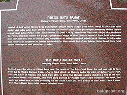
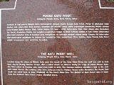
Kampung Minyak Beku
Kampung Minyak Beku is a seaside village lying on the west coast of Johor, Malaysia. Kampung Minyak Beku is where the famous chiseled rock is located, a big rock about ten feet in size . The big rock was chiselled by the Siamese to contain fresh water...
, in hope to get fresh water during their retreat. They were being chased by the Melaka troops, being led by Tun Perak, the famous Bendahara (Prime Minister) of the Malacca Empire. In fact, in around 1456, the Siamese army was led by Admiral Awi Di Chu camped in Batu Pahat before attacking Malacca. Another story goes like this - after capturing Melaka, the Portuguese built a fortress - "A Famosa" of granite rocks taken from the mouth of Sungai Batu Pahat. The town acquired its name, which means "Chiselled Stone" from the quarries near the estuary. Renowned for its salted fish in the past, Batu Pahat was formerly known as Bandar Penggaram, which means town of salt-makers. In 1893/1894, the present township was founded by Dato' Bentara Luar, Mohamed Salleh bin Perang, acting on the orders of the Sultan of Johor, Sultan Abu Bakar.
Today, the ancient well can still be found in Minyak Beku, though little was done to maintain this ancient landmark which gives name to the town. For the town's centennial celebration in the early 90's, a quaint monument depicting a 'floating hand chiselling a rock' was set up in the town square. It became the landmark of the town instantaneously. Currently, the newly refurbished town square is popular with locals to chill out on weekend nights and also provides as a venue for many public festive celebrations.
Bandar Penggaram,Batu Pahat is growing rapidly and has now developed to become the second major town in Johor state after Johor Bahru.
Subdivisions and administration
The district (daerah) is further divided into mukim-mukim (pl.) or subdistricts. The subdistricts are designated with a number (Mukim 1 until 12,17 and 18):- Lubok (Mukim I)
- Bagan (Mukim II)
- Peserai (Mukim III)
- Simpang Kiri (Mukim IV)
- Simpang Kanan (Mukim V)
- Linau (Mukim VI)
- Tanjung Semberong (Mukim VII)
- Sri GadingSri GadingSri Gading is a town as well as parliamentary constituency in Johor, Malaysia, located in the district of Batu Pahat, along Jalan Kluang - Batu Pahat . It lies south-east of Batu Pahat town, north-west of Ayer Hitam and west of Yong Peng.-Origin of name:The name Seri Gading means 'The Gorgeous...
(Mukim VIII) - Minyak Beku (Mukim IX)
- Kampung Bahru (Mukim X)
- Sungai Punggor (Mukim XI)
- Sungai Kluang (Mukim XII)
- Chaah Bahru (Mukim XVII)
- Sri Medan (Mukim XVIII)
Bandar Penggaram,Batu Pahat is administered by Majlis Perbandaran Batu Pahat or Batu Pahat Municipal Council which was upgraded from the previous District Council (Majlis Daerah Batu Pahat Barat)on 9 June 2001 while Yong Peng
Yong Peng
Yong Peng is a regional town in Malaysia in the state of Johor. It has an area of 1911.6 hectares with an estimated population of 29,046. Yong Peng has two main interchanges on North-South Expressway including north to Kuala Lumpur and south to Johor Bahru....
is administered by Majlis Daerah Yong Peng or Yong Peng District Council which previous named Majlis Daerah Batu Pahat Timur.
Batu Pahat district has 525 gazetted villages (kampung-kampung pl.) and village-clusters (kampung rangkaian) where smaller villages were annexed to their bigger immediate neighbours for the purpose of administration. The villages are represented by Ketua-Ketua Kampung (village heads), answering to the Penghulu (subdistrict chief) administering the mukim. The mukim itself however is under the jurisdiction of the District Officer or Pegawai Daerah. The district office of Batu Pahat also have five district engineers (Jurutera Daerah) to oversee all the subdistricts.
Growth in small and medium industries such as textiles, garments and electronics helped to boost development, and Batu Pahat was upgraded to town status (Majlis Perbandaran) in 2001, alongside Muar, Kluang and Skudai. As of 2008, the government does not have any plans to upgrade Batu Pahat to a city status (Majlis Bandaraya).
Towns
- RengitRengitRengit is a town in the Batu Pahat District of Johor, Malaysia. It is the border town between Batu Pahat and Pontian district. Approximately 37km away from Bandar Penggaram,Batu Pahat, capital of Batu Pahat district and 38km away from Pontian Kechil....
- Yong PengYong PengYong Peng is a regional town in Malaysia in the state of Johor. It has an area of 1911.6 hectares with an estimated population of 29,046. Yong Peng has two main interchanges on North-South Expressway including north to Kuala Lumpur and south to Johor Bahru....
- SemerahSemerahSemerah(圣模那)is a small town in Johor, Malaysia. It is the border town between Batu Pahat and Muar district.This small town is basically have a main street with old shop houses and a road to Semerah wet market ....
- Parit SulongParit SulongParit Sulong is a small town in Johor, Malaysia on the Simpang Kiri River, 30 km east of Muar. The historical Parit Sulong Bridge constructed during World War II is a main feature in that town....
- Sri GadingSri GadingSri Gading is a town as well as parliamentary constituency in Johor, Malaysia, located in the district of Batu Pahat, along Jalan Kluang - Batu Pahat . It lies south-east of Batu Pahat town, north-west of Ayer Hitam and west of Yong Peng.-Origin of name:The name Seri Gading means 'The Gorgeous...
- Parit RajaParit RajaParit Raja (巴力拉惹) is a town in Batu Pahat District, Johor, Malaysia. The main population of this town is Javanese. There has been substantial growth in this region for the past few years. Universiti Tun Hussein Onn Malaysia , or Tun Hussein Onn University of Malaysia, is located here...
- Ayer HitamAyer HitamAyer Hitam is a rest town in Johor, Malaysia. Located just at the junction of route and route , it is known for its many outlets selling pottery and other crafts. It also is one of the interchange for North-South Expressway. It is the border town between Batu Pahat and Kluang district...
- SenggarangSenggarangSenggarang may refer to:-*Senggarang - a small town in Johor, Malaysia.*Senggarang - a small town in Indonesia., a Singaporean coaster...
- Tongkang PechahTongkang PechahTongkang Pechah(中江)is a small town in Johor, Malaysia. Its name was taken from the bauxite ore tongkang which sunk in Sungai Simpang Kiri...
Demographics
Whole district of Batu Pahat has a population of about 468,058 local residents. The most populated mukim is Simpang Kanan with more than 311,862 people and the least populated is Bagan with a population of only 4,692.The Chinese
Chinese people
The term Chinese people may refer to any of the following:*People with Han Chinese ethnicity ....
(45%) are concentrated in Bandar Penggaram, Batu Pahat and Yong Peng
Yong Peng
Yong Peng is a regional town in Malaysia in the state of Johor. It has an area of 1911.6 hectares with an estimated population of 29,046. Yong Peng has two main interchanges on North-South Expressway including north to Kuala Lumpur and south to Johor Bahru....
while the other part of Batu Pahat majority are Malay (52%). The India
India
India , officially the Republic of India , is a country in South Asia. It is the seventh-largest country by geographical area, the second-most populous country with over 1.2 billion people, and the most populous democracy in the world...
ns (3%) are less significant in Batu Pahat, working in rubber estates or as area business-owners.
The dialect group of Chinese community in Batu Pahat are varies:
- Bandar Penggaram,Batu Pahat- Mainly Hokkien people and Teochew, followed by HakkaHakka peopleThe Hakka , sometimes Hakka Han, are Han Chinese who speak the Hakka language and have links to the provincial areas of Guangdong, Jiangxi, Guangxi, Sichuan, Hunan and Fujian in China....
. - Yong PengYong PengYong Peng is a regional town in Malaysia in the state of Johor. It has an area of 1911.6 hectares with an estimated population of 29,046. Yong Peng has two main interchanges on North-South Expressway including north to Kuala Lumpur and south to Johor Bahru....
- Mainly Fuzhou and Hokkien.
External links
- Ferry Terminal Batu Pahat
- Batu Pahat District Office
- Majlis Perbandaran Batu Pahat
- Accommodation
- Batu Pahat Online Portal with maps, news, events and movies
- Batu Pahat Online Directory