

AH2
Encyclopedia
Asian Highway Network
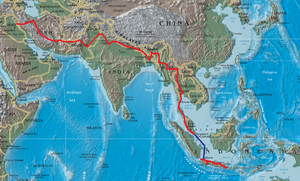
The Asian Highway project, also known as the Great Asian Highway, is a cooperative project among countries in Asia and Europe and the United Nations Economic and Social Commission for Asia and the Pacific , to improve the highway systems in Asia...
running 8230 miles (13,177 km) from Denpasar
Denpasar
Denpasar is the capital city of the province of Bali, Indonesia. It has a rapidly expanding population of 788,445 in 2010, up from 533,252 in the previous decade. It is located at .-History:...
, Indonesia
Indonesia
Indonesia , officially the Republic of Indonesia , is a country in Southeast Asia and Oceania. Indonesia is an archipelago comprising approximately 13,000 islands. It has 33 provinces with over 238 million people, and is the world's fourth most populous country. Indonesia is a republic, with an...
to Khosravi
Khosravi
Khosravi is a town in the eastern mountains of Iraq near the border with Iran. Its elevation is 2100m.- External links :*...
, Iran
Iran
Iran , officially the Islamic Republic of Iran , is a country in Southern and Western Asia. The name "Iran" has been in use natively since the Sassanian era and came into use internationally in 1935, before which the country was known to the Western world as Persia...
. The route is as follows:
Indonesia
DenpasarDenpasar
Denpasar is the capital city of the province of Bali, Indonesia. It has a rapidly expanding population of 788,445 in 2010, up from 533,252 in the previous decade. It is located at .-History:...
— Surabaya
Surabaya
Surabaya is Indonesia's second-largest city with a population of over 2.7 million , and the capital of the province of East Java...
— Surakarta
Surakarta
Surakarta, also called Solo or Sala, is a city in Central Java, Indonesia of more than 520,061 people with a population density of 11,811.5 people/km2. The 44 km2 city adjoins Karanganyar Regency and Boyolali Regency to the north, Karanganyar Regency and Sukoharjo Regency to the east and...
— Semarang
Semarang
- Economy :The western part of the city is home to many industrial parks and factories. The port of Semarang is located on the north coast and it is the main shipping port for the province of Central Java. Many small manufacturers are located in Semarang, producing goods such as textiles,...
— Cikampek
Cikampek
Cikampek is a subdistrict of Karawang Regency, West Java, Indonesia. It is divided into 10 administrative villages . Distance from subdistrict centre Cikampek to karawang is 21 miles.- Transportation :...
(— Bandung
Bandung
Bandung is the capital of West Java province in Indonesia, and the country's third largest city, and 2nd largest metropolitan area in Indonesia, with a population of 7.4 million in 2007. Located 768 metres above sea level, approximately 140 km southeast of Jakarta, Bandung has cooler...
) — Jakarta
Jakarta
Jakarta is the capital and largest city of Indonesia. Officially known as the Special Capital Territory of Jakarta, it is located on the northwest coast of Java, has an area of , and a population of 9,580,000. Jakarta is the country's economic, cultural and political centre...
(— Merak)
See also:
- Trans-Java Toll RoadTrans-Java toll road-Background:Two centuries ago , Dutch East Indies colonial government has made De Groote Postweg or Great Post Road with 1,000 kilometers length between Anyer, Banten province and Panarukan, Situbondo, East Java province...
- Jakarta-Tangerang Toll RoadJakarta-Tangerang Toll RoadThis toll road connects Jakarta with Tangerang. It is the main road for workers who live in the western Jakarta area.-Fee:All the fees are in Rupiah. Decision from Minister of Public Work: 370/KPTS/M/2007 31 August 2007.-External links:**...
- Tangerang-Merak Toll Road
- Jakarta-Cikampek Toll RoadJakarta-Cikampek Toll RoadJakarta-Cikampek toll road opened on 1988. The road links Jakarta and cities in West Java. On 2005, the toll road connects Bandung and Jakarta via Cipularang Toll Road. The interchange to Bandung built before Kalihurip exit...
- Cikampek-Palimanan Toll RoadCikampek-Palimanan toll roadCikampek-Palimanan Toll Road is a toll road that connects the existing Jakarta-Cikampek Toll Road and Palimanan-Kanci Toll Road and is part of the Trans-Java Toll Road...
- Cipularang Toll RoadCipularang Toll RoadJakarta-Cikampek toll road opened on 2005. This road connects Jakarta-Cikampek Toll Road and Padaleunyi Toll Road. The toll road is operated by PT Jasa Marga Tbk.-Exits:Exit In Cipularang Toll Road- Rest area :Rest area In Cipularang...
- Padaleunyi Toll RoadPadaleunyi Toll RoadPadaleunyi Toll Road served for Bandung. On 2005, the toll road connected to Jakarta via Cipularang Toll Road. The toll road is operated by PT Jasa Marga Tbk.The toll road is crossing the South Bandung.- Exits :...
Malaysia
Johor BahruJohor Bahru
Johor Bahru is the capital city of Johor in southern Malaysia. Johor Bahru is the southernmost city of the Eurasian mainland...
— Senai Utara
Senai
Senai is a transit town situated 25 kilometres northwest of Johor Bahru, Malaysia. Apart from the Senai International Airport, it is also the base for several major multinational electronics manufacturers...
— Seremban
Seremban
Seremban is the capital of the Malaysian state of Negeri Sembilan, located within the district of Seremban, one of the seven districts of Negeri Sembilan. The town's administration is run by the Seremban Municipal Council or Majlis Perbandaran Seremban...
— Kuala Lumpur
Kuala Lumpur
Kuala Lumpur is the capital and the second largest city in Malaysia by population. The city proper, making up an area of , has a population of 1.4 million as of 2010. Greater Kuala Lumpur, also known as the Klang Valley, is an urban agglomeration of 7.2 million...
— Butterworth
Butterworth, Penang
Butterworth is the principal town of Seberang Perai in the state of Penang in Malaysia. Named after William John Butterworth, Governor of the Straits Settlements , Butterworth was established in the mid-19th century as a landing place across the channel from the capital of Penang, George Town...
— Bukit Kayu Hitam
Bukit Kayu Hitam
Bukit Kayu Hitam is Kedah's main border town on the Malaysia-Thailand Border. It marks the end of the North-South Expressway and Malaysia Federal Route 1, the longest Malaysian road which runs from Johor Bahru, Johor in the south till the border at Bukit Kayu Hitam pass. The checkpoint and duty...
The status of the section of AH2 crossing the Malaysia-Singapore border is currently being disputed. Malaysia had commissioned the Second Link Expressway
Second Link Expressway
Second Link Expressway , is the expressway which links Senai North at North-South Expressway, Senai Airport and Taman Perling, Johor Bahru via its extension known as Pontian-Johor Bahru Parkway to the Malaysia-Singapore Second Link.Usually, travelling along the second link is much faster than...
as part of AH2 while Singapore had commissioned the Johor-Singapore Causeway
Johor-Singapore Causeway
The Johor–Singapore Causeway is a 1,056-metre causeway that links the city of Johor Bahru in Malaysia across the Straits of Johor to the town of Woodlands in Singapore. It serves as a road, rail, and pedestrian link, as well as water piping into Singapore.The causeway is connected to the...
as part of AH2. For details, see also AH2 border crossing dispute.
See also: North-South Expressway New Klang Valley Expressway
New Klang Valley Expressway
The New Klang Valley Expressway, or the NKVE refers to a stretch of the North-South Expressway in Peninsular Malaysia which starts from Bukit Raja near Klang town, and ends at Jalan Duta in Kuala Lumpur. It is a busiest expressway in Klang Valley during rush hour from/to Kuala Lumpur...
North-South Expressway Central Link
North-South Expressway Central Link
North South Expressway Central Link, NSECL , also known as ELITE or ELITE Highway, is the main expressway in Malaysia. The of the expressway starts from Shah Alam Interchange until Nilai North Interchange...
Second Link Expressway
Second Link Expressway
Second Link Expressway , is the expressway which links Senai North at North-South Expressway, Senai Airport and Taman Perling, Johor Bahru via its extension known as Pontian-Johor Bahru Parkway to the Malaysia-Singapore Second Link.Usually, travelling along the second link is much faster than...
Skudai Highway
Skudai Highway
Skudai Highway , also known as Senai Highway Jalan Tun Abdul Razak or Jalan Skudai, Federal route is a 29 kilometre partial-access highway in Johor, Malaysia, from the town of Senai to the Johor-Singapore Causeway, which connects Malaysia and...
Malaysia Federal Route 1
Malaysia Federal Route 1
Federal Route 1 is the first federal road in Malaysia, and among the oldest federal roads in Malaysia, having been constructed by the British government during colonial times...
- Johor Causeway
Thailand
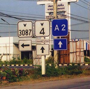
Thailand National Route 4 from Sa Dao to Phatthalung, then Route 41Thailand Route 41
Route 41 starts at intersection with Route 4 in Chumphon Province. It goes southward passing through Surat Thani Province and Nakhon Si Thammarat Province. It ends at Phatthalung Province joining Route 4 again.-Route Details:...
to Chumphon, then Route 4 to Bangkok, then Route 338/Route 9 to Bang Pa-in, overlap with AH1
AH1
AH1 is the longest route of the Asian Highway Network, running 12,845 miles from Tokyo, Japan via Korea, China, Southeast Asia, India, Pakistan, Afghanistan and Iran to the border between Turkey and Bulgaria west of Istanbul.-Japan:...
to Tak, then Route 1 to Mae Sai.
Sa Dao
Amphoe Sadao
Sadao is a small town and district on the border of Malaysia in the Songkhla Province, southern Thailand.-History:Historically Sadao is part of Kedah in the district of Changlun, means 'the falling of an elephant' in Thai. The district were once a part of Changlun, and under the overlordship of...
— Hat Yai
Hat Yai
Hat Yai is a city in southern Thailand near the Malaysian border. Located at , it has a population of 157,359 in the city itself and about 800,000 in the greater Hat Yai area. Hat Yai is the largest city of Songkhla Province, the largest metropolitan area in Southern, and third largest...
— Bangkok
Bangkok
Bangkok is the capital and largest urban area city in Thailand. It is known in Thai as Krung Thep Maha Nakhon or simply Krung Thep , meaning "city of angels." The full name of Bangkok is Krung Thep Mahanakhon Amon Rattanakosin Mahintharayutthaya Mahadilok Phop Noppharat Ratchathani Burirom...
— Bang Pa-in — Nakhon Sawan
Nakhon Sawan Province
Nakhon Sawan is one of the provinces of Thailand. Neighboring provinces are Kamphaeng Phet, Phichit, Phetchabun, Lop Buri, Sing Buri, Chai Nat, Uthai Thani and Tak.- Etymology :...
— Tak
Tak (town)
Tak is a town in northwest of Thailand, capital of the Tak Province and the Tak district. As of 2005 the town has a population of 19,900 and an area of 7.27 km². It covers the tambon Rahaeng, Nong Luang, Chiang Ngoen and Hua Diat, and is located on the Ping River.-External links:*...
— Chiang Rai
Chiang Rai
-Demographics:Official Population count: According to the Thailand National Statistical Office, as of September 2010, Chiang Rai municipal district has a population of 199,699...
— Mae Sai
Mae Sai
Mae Sai is the northernmost district of Chiang Rai Province in northern Thailand. The town of Mae Sai is a major border crossing between Thailand and Burma...
Myanmar
AH 2 uses Route 4 to Meiktila, then overlaps AH1 to TamuTachilek — Keng Tung — Meiktila
Meiktila
Meiktila is a city in central Myanmar, located on the banks of Lake Meiktila in Mandalay Division, at the junctions of the Bagan-Taunggyi, Yangon-Mandalay and Meiktila-Myingyan highways. Because of its strategic position, Meiktila is home to Myanmar Air Force's central command and Meiktila Air...
— Mandalay
Mandalay
Mandalay is the second-largest city and the last royal capital of Burma. Located north of Yangon on the east bank of the Irrawaddy River, the city has a population of one million, and is the capital of Mandalay Region ....
— Tamu
India
MorehMoreh
Moreh is a name of a location, commonly used in the Genesis.-Torah locality:Translators who consider the obscure elon moreh of Genesis 12:6 to be the name of a locality, render it as "the plains of Moreh". Translators who consider the term to be a sacred tree or grove, often render it "terebinth",...
— Imphal
Imphal
Imphal is the capital of the Indian state of Manipur.In the heart of the town and surrounded by a moat, are ruins of the old Palace of Kangla. Kangla Fort used to be the home of the Assam Rifles, a paramilitary force and on November 2004 it was handed over to state of Manipur by Prime minister Dr....
— Kohima
Kohima
Kohima is the hilly capital of India's north eastern border state of Nagaland which shares its borders with Burma. It lies in Kohima District and is also one of the three Nagaland towns with Municipal council status along with Dimapur and Mokokchung....
— Dimapur
Dimapur
Dimapur in Nagaland is bounded by Kohima district on the south and east, Karbi Anglong district of Assam on the West, the Karbi Anglong and stretch of Golaghat District of Assam, in the west and the north...
— Nagaon
Nagaon
Nagaon , is a medium sized city and a municipal board in Nagaon district in the Indian state of Assam. It is situated east of Guwahati. An older spelling of the name is Nowgong.It is one of the fastest growing cities of the northeast.-History:...
— Jorabat
Jorabat
-Geography:It is located at .Jorabat is very near to the city of Guwahati, Assam in Kamrup District-Location:National Highway 40 links Jorabat to Jowai via Shillong. National Highway 37 passes through Jorabat....
(— Guwahati
Guwahati
Guwahati, Pragjyotishpura in ancient Assam formerly known as Gauhati is a metropolis,the largest city of Assam in India and ancient urban area in North East India, with a population of 963,429. It is also the largest metropolitan area in north-eastern India...
) — Shillong
Shillong
-Connectivity:Although well connected by road, Shillong has no rail connection and a proper air connection. Umroi Airport exists but has only limited flights.-Roadways:Shillong is well connected by roads with all major north eastern states...
— Dawki
Dawki
-Geography:It is located at .It is on the border of India Bangladesh.-Location:National Highway 40 passes through Dawki.It is situated in the border of Bangladesh, Tamabil border crossing.-Places of interest:...
Bangladesh
Tamabil — SylhetSylhet
Sylhet , is a major city in north-eastern Bangladesh. It is the main city of Sylhet Division and Sylhet District, and was granted metropolitan city status in March 2009. Sylhet is located on the banks of the Surma Valley and is surrounded by the Jaintia, Khasi and Tripura hills...
— Katchpur — Dhaka
Dhaka
Dhaka is the capital of Bangladesh and the principal city of Dhaka Division. Dhaka is a megacity and one of the major cities of South Asia. Located on the banks of the Buriganga River, Dhaka, along with its metropolitan area, had a population of over 15 million in 2010, making it the largest city...
— Hatikamrul — Banglabandha
Banglabandha
Banglabandha is a major inland port in northern Bangladesh established to provide a trade link with India, Nepal and Bhutan. The three nations are separated by of Indian territory, known as the Siliguri Corridor.-Location:...
Nepal
Kankarbhitta — Pathlaiya — Hetauda — Narayangarh — KohalpurKohalpur
Kohalpur is a town in Banke District in the Bheri Zone in mid-western Nepal. The town is in East-West highway and one of the fastest developing places in Nepal. A neighboring city Nepalgunj is on South , and further 6 km is the Indian border. In fact it is a growing city in the western...
— Mahendranagar — Mahakali River
Pakistan
WagahWagah
Wagah is the only road border crossing between Pakistan and India , and lies on the Grand Trunk Road between the cities of Lahore, Pakistan and Amritsar, India. Wagah itself is a village through which the controversial Radcliffe Line was drawn. The village was divided by independence in 1947...
— Lahore
Lahore
Lahore is the capital of the Pakistani province of Punjab and the second largest city in the country. With a rich and fabulous history dating back to over a thousand years ago, Lahore is no doubt Pakistan's cultural capital. One of the most densely populated cities in the world, Lahore remains a...
— Multan
Multan
Multan , is a city in the Punjab Province of Pakistan and capital of Multan District. It is located in the southern part of the province on the east bank of the Chenab River, more or less in the geographic centre of the country and about from Islamabad, from Lahore and from Karachi...
— Rohri
Rohri
Rohri is a town of Sukkur District, Sindh province, Pakistan. It is located at 27°40'60N 68°54'0E, on the east bank of the Indus River. Rohri town is the administrative headquarters of Rohri Taluka, a tehsil of Sukkur District with which it forms a metropolitan area...
— Quetta
Quetta
is the largest city and the provincial capital of the Balochistan Province of Pakistan. Known as the "Fruit Garden of Pakistan" due to the diversity of its plant and animal wildlife, Quetta is home to the Hazarganji Chiltan National Park, which contains some of the rarest species of wildlife in the...
— Taftan
Taftan (Balochistan)
Taftan is a town located in Chagai District, Balochistan, Pakistan.It is Pakistan's only legal official border crossing into Iran and famed by locals as the "road to London" because it is a famous smuggling route.Over 600 km from Quetta, getting to Taftan is a journey of almost 12 hours of...
Iran
- :MirjavehMirjavehMirjaveh is a city in the capital of Mirjaveh District of Zahedan County, Sistan and Baluchestan Province, Iran. At the 2006 census, its population was 13,590, in 2,350 families....
— ZahedanZahedanZahedan is a city in and the capital of Sistan and Baluchestan Province, Iran. At the 2006 census, its population was 552,706, in 109,488 families.-Geography:...
— KermanKerman- Geological characteristics :For the Iranian paleontologists, Kerman has always been considered a fossil paradise. Finding new dinosaur footprints in 2005 has now revealed new hopes for paleontologists to better understand the history of this area.- Economy :...
- AnarAnar, IranAnar is a city in and the capital of Anar County, Kerman Province, Iran. At the 2006 census, its population was 12,791, in 3,227 families. "Anar" means pomegranate in Persian.... - :AnarAnar, IranAnar is a city in and the capital of Anar County, Kerman Province, Iran. At the 2006 census, its population was 12,791, in 3,227 families. "Anar" means pomegranate in Persian....
— KashanKashanKashan is a city in and the capital of Kashan County, in the province of Isfahan, Iran. At the 2006 census, its population was 248,789, in 67,464 families....
— QomQomQom is a city in Iran. It lies by road southwest of Tehran and is the capital of Qom Province. At the 2006 census, its population was 957,496, in 241,827 families. It is situated on the banks of the Qom River.... - :QomQomQom is a city in Iran. It lies by road southwest of Tehran and is the capital of Qom Province. At the 2006 census, its population was 957,496, in 241,827 families. It is situated on the banks of the Qom River....
— SalafcheganSalafcheganSalafchegan is a city in and the capital of Salafchegan District, in Qom County, Qom Province, Iran. At the 2006 census, its population was 707, in 211 families.... - :SalafcheganSalafcheganSalafchegan is a city in and the capital of Salafchegan District, in Qom County, Qom Province, Iran. At the 2006 census, its population was 707, in 211 families....
— SavehSavehSāveh is a city in the Markazi Province of Iran. It is located around 100 km southwest of Tehran. As of 2006, the city had a population of 179,009 people.-History:In the 7th century BC it was as stronghold of the Medes... - :SavehSavehSāveh is a city in the Markazi Province of Iran. It is located around 100 km southwest of Tehran. As of 2006, the city had a population of 179,009 people.-History:In the 7th century BC it was as stronghold of the Medes...
— HamadanHamadan-Culture:Hamadan is home to many poets and cultural celebrities. The city is also said to be among the world's oldest continuously inhabited cities.Handicrafts: Hamadan has always been well known for handicrafts like leather, ceramic, and beautiful carpets....
— KermanshahKermanshahKermanshah is a city in and the capital of Kermanshah Province, Iran. At the 2006 census, its population was 784,602, in 198,117 families.The overwhelming majority of Kermanshahi people are Shi'a Muslims...
— KhosraviKhosraviKhosravi is a town in the eastern mountains of Iraq near the border with Iran. Its elevation is 2100m.- External links :*...