
Lustleigh
Encyclopedia
Lustleigh is a small village nestled in the Wrey Valley, inside the Dartmoor National Park in Devon
, England
. It sits between the towns of Bovey Tracey
and Moretonhampstead
.
The village is focused around the parish church of St John the Baptist
. Surrounding this are old buildings, many of which are thatched. There is a village shop, garage, tea room and a pub. There was formerly a Post Office but this closed in 2009, however the village is currently served by an outreach Post Office located in the shop.
Whilst the name Lustleigh (or any variation) is not found in the Domesday Book
, it is believed that the village was recorded under the name of Sutreworde, Anglo Saxon
for 'South of the Wood'.
At that time, the Lord of the Manor was Ansgar, who controlled 12 farms of around 1,200 acres (4.9 km²) plus a large area of forest
. Unusually for the Domesday book, beekeeping
was mentioned as a key activity of the parish. At the time of the Domesday survey, there were around 155 people living in the village. Lustleigh continued as an estate manor until the beginning of the 19th century when it was broken up and sold off.
Over time, the village expanded from its original boundaries
(signified by the Bishop's stone at Caseley as the entrance, and the Wrey brook in the valley), to encompass the area beyond the Wrey brook (known as Wreyland) which was previously a separate village - although its residents attended Lustleigh's parish church - and out to Brookfield (in 1957).
parish
church. It is at the centre of the village.
The oval shape of the churchyard suggests that a Romano-British burial ground may have first occupied this site. This conjecture is supported by the presence of Datuidoc's Stone in the north aisle (originally in the porch), dating from around AD 550-600.
The first part of the church, including the basic rectangle and the south porch, was built around 1250. The south chapel was added in the early 14th century by the Lord of the Manor, Sir William le Prouse. The church tower was built in the late 14th century. In the 15th century the north aisle was built, including removal of the north wall and replacing it with pillars.
The last major addition to the church was the vestry, built in Victorian times.
The church graveyard
contains the remains of former Lustleigh residents. The graveyard is now full, and with the exception of those with family plots, new burials take place at the modern cemetery on Mill Lane.
in 1799. The Bilbie family were prolific founders and bellhangers and examples of their work still exist in the county. These Bilbie bells would almost certainly have been recast from the metal of the previous bells, probably near the church as transporting bells once cast was difficult. Two of the inscriptions on the bells included the names of the churchwardens of the time, Elias Cuming and John Amery, although Ellacombe's notes spell Cuming differently on each bell; this may be an error on his part or more probably on the part of the foundry.
In 1875 William Aggett of Chagford
, a local bellhanger, hung a fifth bell, a new treble, in the tower; it was cast by Taylors bellfoundry
of Loughborough
who are still in business. In 1923 Gillett & Johnston
of Croydon
recast all the bells and augmented them to six with a tenor bell weighing 12 long cwt (609.6 kg). These are the bells that hang in the church today and ring out on Sunday morning and other times. The inscription of the old bells was reproduced on the new bells, although Gillett & Johnston reproduced the name "Bilbie" as "Billie" on every bell. The bells were substantially overhauled in 2008 by Nicholson Bellhangers and the tower steeple keeper Robert Brown of Bovey Tracey.
Church is on Rudge Hill, and was built in around 1853 by people of the village, most notably including the large Amery family, who have one of the longest associations with the village.
Hall is below the village green, next to the Primrose Cottage tea rooms, on the Wreyland path. Its history dates back to the 1900s when worship was conducted in the homes of adherents. Sometime in the early 20th century, a Mrs L.A. Whiteside made the building available to the congregation. This continued until 1971, when the congregation purchased the building from the landlord, and it is still active today.
chapel, beside Pixies Cottage on Mapstone Hill. The owner, Dolly Walmsley, moved away in 1984, leading to the sale of the cottage and chapel, and the cessation of church services.
celebrations are the biggest event of the year for the village, with a carnival procession, maypole dancing, and crowning of the May Queen. The May Day tradition had lapsed until 1905, when Cecil Torr revived it. The celebrations have since been held on the first Saturday in May. Initially the 'crowning' took place on a hillside above Wreyland. The granite boulder where the ceremony took place has inscribed upon it the names of all the May Queens up to the beginning of the Second World War when the event was suspended.
In 1954, the celebrations were again revived and moved to the Town Orchard where the May Queen's throne was erected on a rock. Like its predecessor this rock, known as the May Day Rock, has the names of all the May Queens inscribed on it from 1954 to the present. In May 2000 a new throne was unveiled at the May Day celebrations. The throne was cut from granite from the nearby Blackingstone Quarry. It was designed by Doug Cooper and carved by Warren Pappas; on it is inscribed 'MM'.
The May Queens since the revival in 1905 were:
The show is usually held in the fields at Kelly Farm, although during the Foot and Mouth year it was held on the field next to the cricket field.
It is not known when the show started, but it gradually grew to incorporate the local flower show, previously held at the Conservative Hall (where the village hall now stands). Until 1990, the Lustleigh horticultural society organised the show, but subsequently a separate committee organised it. In 1998, this split further, with the growing horse show being organised separately from the rest of the show.
Surplus funds raised from the show are spent in the village on numerous community projects and good causes. Thus far more than £15,000 has been reinvested in the village.
The show is sometimes preceded on the Saturday by the "can't miss" show dance: the locals gather in the show tent for music, dinner and dancing. For the dance most of the village dresses in costume for a night's entertainment in a themed tent. The music is often provided by a local band, such as Scratch, who have featured in the show since 1997.
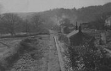
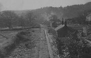 Lustleigh Station, and the smaller Hawkmoor Halt, were stops on the Moretonhampstead and South Devon Railway
, a 12.3 mile (20 km) branch of the South Devon Main Line
from Newton Abbot
to Moretonhampstead
.
The Moretonhampstead and South Devon Railway company was formed in 1861, and work on the line commenced in 1863. The line opened to the public in 1866 and converted from broad gauge
to standard gauge
in 1892.
The railway brought tourists to the area, and this led to local business flourishing. The conveniently placed Gatehouse Farm was converted into the Cleave Hotel, still the village pub to this day. The railway was also used by local industries: farmers' produce, nursery plants and blacksmiths' products were all sent by train.
The station was used in 1931 for the film 'Hound of the Baskervilles', its name being temporarily changed (Ewans 1964).
Railway traffic grew until the 1930s when it went into decline. Despite a significant summer tourist trade, being featured in many contemporary guide books to the region, traffic was not enough to cover rising costs.
In 1957, the possibility of closure was reported in the Mid Devon Advertiser. In 1959 the last passenger service ran, although freight trains continued. The line closed in 1964 (several years before the Beeching axe
).
Several miles of the line between Bovey Tracey
and Lustleigh, some of which is now a public path, are planned by the council to become a cycle track. The old Lustleigh station house is visible from the old railway bridge at Brookfield, as are the Brookfield, Caseley and Knowle bridges.
Devon
Devon is a large county in southwestern England. The county is sometimes referred to as Devonshire, although the term is rarely used inside the county itself as the county has never been officially "shired", it often indicates a traditional or historical context.The county shares borders with...
, England
England
England is a country that is part of the United Kingdom. It shares land borders with Scotland to the north and Wales to the west; the Irish Sea is to the north west, the Celtic Sea to the south west, with the North Sea to the east and the English Channel to the south separating it from continental...
. It sits between the towns of Bovey Tracey
Bovey Tracey
Bovey Tracey is a small town in Devon, England, on the edge of Dartmoor, its proximity to which gives rise to the "slogan" used on the town's boundary signs, "The Gateway to the Moor". The locals just call the town "Bovey" ....
and Moretonhampstead
Moretonhampstead
Moretonhampstead lies on the edge of Dartmoor and is notable for having the longest one-word name of any place in England. The parish church is dedicated to St. Andrew. George Oliver and John Pike Jones , 1828, Exeter: E. Woolmer. Moretonhampstead is twinned with Betton in France.-History:The...
.
The village is focused around the parish church of St John the Baptist
John the Baptist
John the Baptist was an itinerant preacher and a major religious figure mentioned in the Canonical gospels. He is described in the Gospel of Luke as a relative of Jesus, who led a movement of baptism at the Jordan River...
. Surrounding this are old buildings, many of which are thatched. There is a village shop, garage, tea room and a pub. There was formerly a Post Office but this closed in 2009, however the village is currently served by an outreach Post Office located in the shop.
History of the village
The area where Lustleigh now stands has been inhabited since before records began as shown by the remains of stone hut circles, which can still be seen in the 'Cleave' (meaning 'Cliff' or 'Cleft', which is the defining geological feature of the valley) and the presence of an ancient burial monument "Datuidoc's Stone" which dates from before AD 600.Whilst the name Lustleigh (or any variation) is not found in the Domesday Book
Domesday Book
Domesday Book , now held at The National Archives, Kew, Richmond upon Thames in South West London, is the record of the great survey of much of England and parts of Wales completed in 1086...
, it is believed that the village was recorded under the name of Sutreworde, Anglo Saxon
Anglo-Saxons
Anglo-Saxon is a term used by historians to designate the Germanic tribes who invaded and settled the south and east of Great Britain beginning in the early 5th century AD, and the period from their creation of the English nation to the Norman conquest. The Anglo-Saxon Era denotes the period of...
for 'South of the Wood'.
At that time, the Lord of the Manor was Ansgar, who controlled 12 farms of around 1,200 acres (4.9 km²) plus a large area of forest
Forest
A forest, also referred to as a wood or the woods, is an area with a high density of trees. As with cities, depending where you are in the world, what is considered a forest may vary significantly in size and have various classification according to how and what of the forest is composed...
. Unusually for the Domesday book, beekeeping
Beekeeping
Beekeeping is the maintenance of honey bee colonies, commonly in hives, by humans. A beekeeper keeps bees in order to collect honey and other products of the hive , to pollinate crops, or to produce bees for sale to other beekeepers...
was mentioned as a key activity of the parish. At the time of the Domesday survey, there were around 155 people living in the village. Lustleigh continued as an estate manor until the beginning of the 19th century when it was broken up and sold off.
Over time, the village expanded from its original boundaries
Border
Borders define geographic boundaries of political entities or legal jurisdictions, such as governments, sovereign states, federated states and other subnational entities. Some borders—such as a state's internal administrative borders, or inter-state borders within the Schengen Area—are open and...
(signified by the Bishop's stone at Caseley as the entrance, and the Wrey brook in the valley), to encompass the area beyond the Wrey brook (known as Wreyland) which was previously a separate village - although its residents attended Lustleigh's parish church - and out to Brookfield (in 1957).
Lustleigh now
The village has a population of between 600 and 700 (614 at the 1991 census), who are served by a number of public amenities, which include:- The Village Hall - opened in February 2005 (much enlarging and improving the previous facility).
- The Dairy - the village shopRetailingRetail consists of the sale of physical goods or merchandise from a fixed location, such as a department store, boutique or kiosk, or by mail, in small or individual lots for direct consumption by the purchaser. Retailing may include subordinated services, such as delivery. Purchasers may be...
, with everyday grocery items and locally produced specialities. The building is owned by the village, and leased to a shopkeeper. Limited Post-office facilities are now available in The Dairy. - The Primrose Cottage - thatched tea rooms, serving food and drink, including cream teaCream teaA cream tea, Devonshire tea, Devon cream tea or Cornish cream tea is tea taken with a combination of scones, clotted cream, and jam....
s. - The Cleave Public House - the local pub, which was converted from a farmhouse in to 'The Cleave Hotel' with the coming of the railway to the village.
Places of interest
- Celtic CrossCeltic crossA Celtic cross is a symbol that combines a cross with a ring surrounding the intersection. In the Celtic Christian world it was combined with the Christian cross and this design was often used for high crosses – a free-standing cross made of stone and often richly decorated...
- a granite monument in front of the church on the village green, next to the Primrose Cottage tea rooms, and up the hill from the Gospel Hall on Wreyland path. - Wreyland - This area of Lustleigh is considered picturesque, due to the large number of thatched houses, including Wrayland Manor, Souther Wreyland, Yonder Wreyland and the Tallet House. Wreyland was not formerly a part of Lustleigh, but was incorporated into the village in the 19th century.
- The Orchard - common land gifted to the village some years ago, with a children's playground. A large graniteGraniteGranite is a common and widely occurring type of intrusive, felsic, igneous rock. Granite usually has a medium- to coarse-grained texture. Occasionally some individual crystals are larger than the groundmass, in which case the texture is known as porphyritic. A granitic rock with a porphyritic...
boulder, topped by a granite throneThroneA throne is the official chair or seat upon which a monarch is seated on state or ceremonial occasions. "Throne" in an abstract sense can also refer to the monarchy or the Crown itself, an instance of metonymy, and is also used in many expressions such as "the power behind the...
, is used for the annual coronation of the May Queen (see Lustleigh May Queen below). - Kelly Mine - old mineMiningMining is the extraction of valuable minerals or other geological materials from the earth, from an ore body, vein or seam. The term also includes the removal of soil. Materials recovered by mining include base metals, precious metals, iron, uranium, coal, diamonds, limestone, oil shale, rock...
workings, occasionally opened to the public. Opened for tours at other times by appointment. - The Cleave - Lustleigh Cleave, meaning "cliff" or "cleft", is the large geological feature from which the village pub derives its name. Paths criss-cross the Cleave (which is mostly common land) and surrounding fields, meadows and woods. Walkers may enjoy the views to the moor from the ridge or the lazy bubble of the River Bovey as it flows along the wooded valley bottom. Wildlife to be seen includes deer, rare butterflies and the pretty river bird, the dipper. In early June the slopes are covered in masses of bluebells and foxgloves.
- Pullabrook Woods - These woods are managed in parts by the Woodland TrustWoodland TrustThe Woodland Trust is a conservation charity in the United Kingdom concerned with the protection and sympathetic management of native woodland heritage.-History:...
, English NatureEnglish NatureEnglish Nature was the United Kingdom government agency that promoted the conservation of wildlife, geology and wild places throughout England between 1990 and 2006...
and Dartmoor National park, nestle at the foot of the moors, and are a destination for walkers and riders. They are accessible from the village, either along Knowle Road, to where the twin bridges over the Wrey run, or from Rudge down either the Heaven's Gate or Hisley paths. - The Bishop's Stone - Commemorating the visit of the Bishop of ExeterBishop of ExeterThe Bishop of Exeter is the Ordinary of the Church of England Diocese of Exeter in the Province of Canterbury. The incumbent usually signs his name as Exon or incorporates this in his signature....
, this stone, at the bottom of Caseley Hill and the top of the station approach road can still be seen, although worn by years of neglect. - Datuidoc's Stone - Lustleigh's most ancient monument, dating from around AD 550-600 is now in the church, and marked a burial site in a graveyard on the site of the present church.
The Church of St John the Baptist
The church of St John the Baptist is the village's Church of EnglandChurch of England
The Church of England is the officially established Christian church in England and the Mother Church of the worldwide Anglican Communion. The church considers itself within the tradition of Western Christianity and dates its formal establishment principally to the mission to England by St...
parish
Parish
A parish is a territorial unit historically under the pastoral care and clerical jurisdiction of one parish priest, who might be assisted in his pastoral duties by a curate or curates - also priests but not the parish priest - from a more or less central parish church with its associated organization...
church. It is at the centre of the village.
The oval shape of the churchyard suggests that a Romano-British burial ground may have first occupied this site. This conjecture is supported by the presence of Datuidoc's Stone in the north aisle (originally in the porch), dating from around AD 550-600.
The first part of the church, including the basic rectangle and the south porch, was built around 1250. The south chapel was added in the early 14th century by the Lord of the Manor, Sir William le Prouse. The church tower was built in the late 14th century. In the 15th century the north aisle was built, including removal of the north wall and replacing it with pillars.
The last major addition to the church was the vestry, built in Victorian times.
The church graveyard
Graveyard
A graveyard is any place set aside for long-term burial of the dead, with or without monuments such as headstones...
contains the remains of former Lustleigh residents. The graveyard is now full, and with the exception of those with family plots, new burials take place at the modern cemetery on Mill Lane.
Church bells
In 1553, the inventory of church goods lists Lustleigh as having four bells, which was normal at the time (with most churches having either three or four). In October 1864 the Reverend H. T. Ellacombe recorded that Lustleigh had four bells, cast by Thomas Castleman Bilbie of CullomptonCullompton
Cullompton is a civil parish and town in Devon, England, locally known as Cully. It is miles north-north-east of Exeter and lies on the River Culm. In 2010 it had a population of 8,639 and is growing rapidly....
in 1799. The Bilbie family were prolific founders and bellhangers and examples of their work still exist in the county. These Bilbie bells would almost certainly have been recast from the metal of the previous bells, probably near the church as transporting bells once cast was difficult. Two of the inscriptions on the bells included the names of the churchwardens of the time, Elias Cuming and John Amery, although Ellacombe's notes spell Cuming differently on each bell; this may be an error on his part or more probably on the part of the foundry.
In 1875 William Aggett of Chagford
Chagford
Chagford is a small town and civil parish on the north-east edge of Dartmoor, in Devon, England, close to the River Teign. It is located off the A382, about 4 miles west of Moretonhampstead. The name Chagford is derived from the word chag, meaning gorse or broom, and the ford suffix indicates its...
, a local bellhanger, hung a fifth bell, a new treble, in the tower; it was cast by Taylors bellfoundry
John Taylor Bellfounders
John Taylor & Co, formerly trading as Taylors, Eayre & Smith Ltd and John Taylor Bellfounders Ltd, and commonly known as Taylor's Bell Foundry or simply Taylor's, is the world's largest working bell foundry, located in Loughborough in the United Kingdom.The company manufactures bells for use in...
of Loughborough
Loughborough
Loughborough is a town within the Charnwood borough of Leicestershire, England. It is the seat of Charnwood Borough Council and is home to Loughborough University...
who are still in business. In 1923 Gillett & Johnston
Gillett & Johnston
Gillett and Johnston is a clock and formerly bell manufacturing business in Croydon, England.-History:William Gillett started a clock making business on Union Road in Croydon, England in 1844. Charles Bland became a partner in 1854 and the company became known as Gillet and Bland. In 1877, Arthur...
of Croydon
Croydon
Croydon is a town in South London, England, located within the London Borough of Croydon to which it gives its name. It is situated south of Charing Cross...
recast all the bells and augmented them to six with a tenor bell weighing 12 long cwt (609.6 kg). These are the bells that hang in the church today and ring out on Sunday morning and other times. The inscription of the old bells was reproduced on the new bells, although Gillett & Johnston reproduced the name "Bilbie" as "Billie" on every bell. The bells were substantially overhauled in 2008 by Nicholson Bellhangers and the tower steeple keeper Robert Brown of Bovey Tracey.
The East Dartmoor Baptist Church
The BaptistBaptist
Baptists comprise a group of Christian denominations and churches that subscribe to a doctrine that baptism should be performed only for professing believers , and that it must be done by immersion...
Church is on Rudge Hill, and was built in around 1853 by people of the village, most notably including the large Amery family, who have one of the longest associations with the village.
The Gospel Hall
The GospelGospel
A gospel is an account, often written, that describes the life of Jesus of Nazareth. In a more general sense the term "gospel" may refer to the good news message of the New Testament. It is primarily used in reference to the four canonical gospels of Matthew, Mark, Luke, and John...
Hall is below the village green, next to the Primrose Cottage tea rooms, on the Wreyland path. Its history dates back to the 1900s when worship was conducted in the homes of adherents. Sometime in the early 20th century, a Mrs L.A. Whiteside made the building available to the congregation. This continued until 1971, when the congregation purchased the building from the landlord, and it is still active today.
The Roman Catholic Chapel
There was previously a private CatholicCatholic
The word catholic comes from the Greek phrase , meaning "on the whole," "according to the whole" or "in general", and is a combination of the Greek words meaning "about" and meaning "whole"...
chapel, beside Pixies Cottage on Mapstone Hill. The owner, Dolly Walmsley, moved away in 1984, leading to the sale of the cottage and chapel, and the cessation of church services.
May Day Celebrations
The May DayMay Day
May Day on May 1 is an ancient northern hemisphere spring festival and usually a public holiday; it is also a traditional spring holiday in many cultures....
celebrations are the biggest event of the year for the village, with a carnival procession, maypole dancing, and crowning of the May Queen. The May Day tradition had lapsed until 1905, when Cecil Torr revived it. The celebrations have since been held on the first Saturday in May. Initially the 'crowning' took place on a hillside above Wreyland. The granite boulder where the ceremony took place has inscribed upon it the names of all the May Queens up to the beginning of the Second World War when the event was suspended.
In 1954, the celebrations were again revived and moved to the Town Orchard where the May Queen's throne was erected on a rock. Like its predecessor this rock, known as the May Day Rock, has the names of all the May Queens inscribed on it from 1954 to the present. In May 2000 a new throne was unveiled at the May Day celebrations. The throne was cut from granite from the nearby Blackingstone Quarry. It was designed by Doug Cooper and carved by Warren Pappas; on it is inscribed 'MM'.
The May Queens since the revival in 1905 were:
| Year | Queen | Year | Queen | Year | Queen |
|---|---|---|---|---|---|
| 1905 | Mabel Bunclarke | 1941 | No Ceremony | 1977 | Debbie Seabrook |
| 1906 | Olive Chudley | 1942 | No Ceremony | 1978 | Heather Wright |
| 1907 | Annie Menhennett | 1943 | No Ceremony | 1979 | Julie Osbourne |
| 1908 | Amy Wyatt | 1944 | No Ceremony | 1980 | Susan Aggett |
| 1909 | Florrie Valance | 1945 | No Ceremony | 1981 | Rebecca French |
| 1910 | Ethel Squires | 1946 | No Ceremony | 1982 | Jeanette Palmer |
| 1911 | Alice Howard | 1947 | No Ceremony | 1983 | Lisa Rowe |
| 1912 | Dorothy Motton | 1948 | No Ceremony | 1984 | Debbie Goodfellow |
| 1913 | Muriel Brimblecombe | 1949 | No Ceremony | 1985 | Sarah Jane Lilley |
| 1914 | Janie Lake | 1950 | No Ceremony | 1986 | Carolyn Tapson |
| 1915 | Guinevere Morecombe | 1951 | No Ceremony | 1987 | Salley Ann Lilley |
| 1916 | Irene Crockford | 1952 | No Ceremony | 1988 | Rebecca Merriott |
| 1917 | May Yeoman | 1953 | Gillian Williams | 1989 | Kim Hopwood |
| 1918 | Gertrude Parker | 1954 | Myra Brock | 1990 | Coralie Olver |
| 1919 | Gladys Waldron | 1955 | Patricia Powell | 1991 | Abigail Mabey |
| 1920 | Vera Hill | 1956 | Janet Horrell | 1992 | Katie Jacoby |
| 1921 | May Wonnacott | 1957 | Helen Beard | 1993 | Simone Olver |
| 1922 | Phyllis Yeoman | 1958 | Christine Moore | 1994 | Lisa Roberts |
| 1923 | Florrie Aggett | 1959 | Iona Jones | 1995 | Natalie Davis |
| 1924 | Josephine Wilson | 1960 | Jayne Nelson | 1996 | Rebecca Drewett |
| 1925 | Romola Wills | 1961 | Jennifer Perry | 1997 | Laura Dale |
| 1926 | Dolly White | 1962 | Ruth Matthews | 1998 | Louise Baudouy |
| 1927 | Phyllis Yeoman | 1963 | Carola Woodger | 1999 | Daisy Beare |
| 1928 | Kathleen Cooper | 1964 | Jaqueline Kennett | 2000 | Emma Wills |
| 1929 | Mary Marshall | 1965 | Patricia Johnson | 2001 | Joely Badger |
| 1930 | Winifred Horrell | 1966 | Angela Woodger | 2002 | Harriet Knowles |
| 1931 | Brenda Osbourne | 1967 | Vivienne Jenkin | 2003 | Lucy James |
| 1932 | May Clarke | 1968 | Suzanne Beaumont | 2004 | Annie Reddaway |
| 1933 | Winifred Olding | 1969 | Jane Aggett | 2005 | Chloe May Wright |
| 1934 | 1970 | Wendy Harvey | 2006 | Anna Bell | |
| 1935 | 1971 | Julie Germon | 2007 | Jessica Beare | |
| 1936 | 1972 | 2008 | Alice James | ||
| 1937 | 1973 | Diane Aggett | 2009 | Kirsty Heather | |
| 1938 | 1974 | Caroline Williams | 2010 | Bryony Bell | |
| 1939 | 1975 | Annette Stephens | |||
| 1940 | 1976 | Catherine Beaumont |
Lustleigh Village Show and Dance
On August Bank Holiday Monday the village hosts a large show, which in 2010 attracted more than 4500 visitors. The show has classes for items ranging from fruit and vegetables to photography, as well as a horse show and a dog show. There are also stalls and activities, a 10 km charity run, terrier racing, displays from local charities and sheep shearing demonstrations.The show is usually held in the fields at Kelly Farm, although during the Foot and Mouth year it was held on the field next to the cricket field.
It is not known when the show started, but it gradually grew to incorporate the local flower show, previously held at the Conservative Hall (where the village hall now stands). Until 1990, the Lustleigh horticultural society organised the show, but subsequently a separate committee organised it. In 1998, this split further, with the growing horse show being organised separately from the rest of the show.
Surplus funds raised from the show are spent in the village on numerous community projects and good causes. Thus far more than £15,000 has been reinvested in the village.
The show is sometimes preceded on the Saturday by the "can't miss" show dance: the locals gather in the show tent for music, dinner and dancing. For the dance most of the village dresses in costume for a night's entertainment in a themed tent. The music is often provided by a local band, such as Scratch, who have featured in the show since 1997.
The Railway and Lustleigh
Moretonhampstead and South Devon Railway
The Moretonhampstead and South Devon Railway was a broad gauge railway which linked the South Devon Railway at Newton Abbot railway station with Bovey Tracey and Moretonhampstead, Devon, England.-History of the line:...
, a 12.3 mile (20 km) branch of the South Devon Main Line
South Devon Railway Company
The South Devon Railway Company built and operated the railway from Exeter to Plymouth and Torquay in Devon, England. It was a broad gauge railway built by Isambard Kingdom Brunel-Chronology:* 1844 South Devon Railway Act passed by parliament...
from Newton Abbot
Newton Abbot
Newton Abbot is a market town and civil parish in the Teignbridge District of Devon, England on the River Teign, with a population of 23,580....
to Moretonhampstead
Moretonhampstead
Moretonhampstead lies on the edge of Dartmoor and is notable for having the longest one-word name of any place in England. The parish church is dedicated to St. Andrew. George Oliver and John Pike Jones , 1828, Exeter: E. Woolmer. Moretonhampstead is twinned with Betton in France.-History:The...
.
The Moretonhampstead and South Devon Railway company was formed in 1861, and work on the line commenced in 1863. The line opened to the public in 1866 and converted from broad gauge
Broad gauge
Broad-gauge railways use a track gauge greater than the standard gauge of .- List :For list see: List of broad gauges, by gauge and country- History :...
to standard gauge
Standard gauge
The standard gauge is a widely-used track gauge . Approximately 60% of the world's existing railway lines are built to this gauge...
in 1892.
The railway brought tourists to the area, and this led to local business flourishing. The conveniently placed Gatehouse Farm was converted into the Cleave Hotel, still the village pub to this day. The railway was also used by local industries: farmers' produce, nursery plants and blacksmiths' products were all sent by train.
The station was used in 1931 for the film 'Hound of the Baskervilles', its name being temporarily changed (Ewans 1964).
Railway traffic grew until the 1930s when it went into decline. Despite a significant summer tourist trade, being featured in many contemporary guide books to the region, traffic was not enough to cover rising costs.
In 1957, the possibility of closure was reported in the Mid Devon Advertiser. In 1959 the last passenger service ran, although freight trains continued. The line closed in 1964 (several years before the Beeching axe
Beeching Axe
The Beeching Axe or the Beeching Cuts are informal names for the British Government's attempt in the 1960s to reduce the cost of running British Railways, the nationalised railway system in the United Kingdom. The name is that of the main author of The Reshaping of British Railways, Dr Richard...
).
Several miles of the line between Bovey Tracey
Bovey Tracey
Bovey Tracey is a small town in Devon, England, on the edge of Dartmoor, its proximity to which gives rise to the "slogan" used on the town's boundary signs, "The Gateway to the Moor". The locals just call the town "Bovey" ....
and Lustleigh, some of which is now a public path, are planned by the council to become a cycle track. The old Lustleigh station house is visible from the old railway bridge at Brookfield, as are the Brookfield, Caseley and Knowle bridges.