
Loyalsock Trail
Encyclopedia
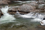
The Loyalsock Trail is a 59.3 mi (95.4 km) hiking
trail
along Loyalsock Creek
in Lycoming
and Sullivan
counties in north central Pennsylvania
in the United States
.
, 10 mi (16 km) north of Montoursville
and 9 mi (14.5 km) north of
I-180
. The eastern terminus of the trail is on Meade Road, 0.2 mi (0.3 km) from U.S. Route 220
, north of Laporte
.
Most of the trail is on Pennsylvania State Forest lands, in the Loyalsock State Forest
. Prior to the state forest reorganization on July 1, 2005 the trail ran through the eastern Tiadaghton State Forest
in Lycoming County and the Wyoming State Forest
in Sullivan County.
The trail has many climbs and offer many vistas. The lowest point on the trail is at 665 ft (203 m) above sea level
, while the highest point is at 2140 ft (652 m).
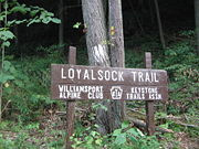 The trail was first laid out in 1951 by Troop 10 of the Explorer Scouts of the Boy Scouts of America
from Williamsport. The original trail was 30.4 miles (48.9 km) long. In 1953, the Alpine Club of Williamsport
was formed to maintain the trail, and still does so today. It also publishes a guide to the trail, which was updated in 2005. The trail reached its present length by 1962, although sections of the trail have been moved five times since, along with many changes in and relocations of side- and link-trails.
The trail is named for the Loyalsock Creek, whose name comes from the Native American
name Lawi-saquick or "middle creek", as it is between Lycoming Creek
and Muncy Creek
. A section of the trail follows part of the Towanda path, a Native American trail. Other portions follow old abandoned logging
roads and railroad grades. These are left over from the 19th and early 20th century when the lumber
industry cut down almost all the trees in the area.
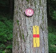 The trail is blazed using red metal disks with the yellow letters "LT" painted in the center. An abrupt direction change is marked with double blazes. In addition to the metal disks (which are can lids), 2 in by 6 in (5 cm by 15 cm) painted yellow rectangles with a 1 in (2.5 cm) horizontal red stripe are also used as blazes. A yellow arrow in the proper direction is used to mark turns.
From the LT web site,Sept.04, 2011 "LT Trail Blazes
What colors are the blazes on the Loyalsock Trail?
Previously, blazes were a red disc with a yellow LT.New LT Trail Blazes
They have been replaced by a yellow disc bearing a red LT - as seen to the right
Be cautious at intersections with Red X trails which are blazed with yellow discs bearing a red X"
Membership Info
LT History
The three kinds of side trails are:
Side trails are described in the guide available from the Alpine Club.
Hiking
Hiking is an outdoor activity which consists of walking in natural environments, often in mountainous or other scenic terrain. People often hike on hiking trails. It is such a popular activity that there are numerous hiking organizations worldwide. The health benefits of different types of hiking...
trail
Trail
A trail is a path with a rough beaten or dirt/stone surface used for travel. Trails may be for use only by walkers and in some places are the main access route to remote settlements...
along Loyalsock Creek
Loyalsock Creek
Loyalsock Creek is a tributary of the West Branch Susquehanna River located chiefly in Sullivan and Lycoming counties in Pennsylvania in the United States...
in Lycoming
Lycoming County, Pennsylvania
-Appalachian Mountains and Allegheny Plateau:Lycoming County is divided between the Appalachian Mountains in the south, the dissected Allegheny Plateau in the north and east, and the valley of the West Branch Susquehanna River between these.-West Branch Susquehanna River:The West Branch of the...
and Sullivan
Sullivan County, Pennsylvania
Sullivan County is a county located in the U.S. state of Pennsylvania. As of 2010, the population is 6,428. Sullivan County was created on March 15, 1847, from part of Lycoming County and named for Charles Sullivan, leader of the Pennsylvania Senate...
counties in north central Pennsylvania
Pennsylvania
The Commonwealth of Pennsylvania is a U.S. state that is located in the Northeastern and Mid-Atlantic regions of the United States. The state borders Delaware and Maryland to the south, West Virginia to the southwest, Ohio to the west, New York and Ontario, Canada, to the north, and New Jersey to...
in the United States
United States
The United States of America is a federal constitutional republic comprising fifty states and a federal district...
.
Geography
The western terminus of the trail is on Pennsylvania Route 87Pennsylvania Route 87
Pennsylvania Route 87 is a long north–south state highway located in northern Pennsylvania. The southern terminus of the route is at exit 21 of Interstate 180 and U.S. Route 220 in Montoursville. The northern terminus is at U.S. Route 6 in Washington Township.The road is called Loyalsock...
, 10 mi (16 km) north of Montoursville
Montoursville, Pennsylvania
Montoursville is a borough in Lycoming County, Pennsylvania, in the United States. As of the 2000 census, the borough population was 4,777. It is part of the Williamsport, Pennsylvania Metropolitan Statistical Area. It was named for Madame Montour, a Native American leader and skilled interpreter...
and 9 mi (14.5 km) north of
I-180
Interstate 180 (Pennsylvania)
Interstate 180 is a spur highway that connects Williamsport, Pennsylvania to Interstate 80 near Milton, Pennsylvania. The length of the highway is . It was also the designation of present-day Interstate 176 between Morgantown, Pennsylvania and Reading, when the Pennsylvania Turnpike carried the...
. The eastern terminus of the trail is on Meade Road, 0.2 mi (0.3 km) from U.S. Route 220
U.S. Route 220
U.S. Route 220 is a long U.S. Route in the eastern United States.US 220 is a spur route of U.S. Route 20 but at present, the two routes do not intersect nor do they connect via other spurs of US 20. The former U. S. Route 120, which was signed in Pennsylvania between 1926 and 1967, intersected...
, north of Laporte
Laporte, Pennsylvania
Laporte is a borough in Sullivan County, Pennsylvania, United States. The population was 316 at the 2010 census. It is the county seat of Sullivan County. Laporte is surrounded by Laporte Township. It was named for John Laporte...
.
Most of the trail is on Pennsylvania State Forest lands, in the Loyalsock State Forest
Loyalsock State Forest
Loyalsock State Forest is a Pennsylvania state forest in Pennsylvania Bureau of Forestry District #20. On July 1, 2005, a reorganization of Pennsylvania State Forests in eastern Pennsylvania resulted in the creation of the "Loyalsock State Forest" and the elimination of the name Wyoming State...
. Prior to the state forest reorganization on July 1, 2005 the trail ran through the eastern Tiadaghton State Forest
Tiadaghton State Forest
Tiadaghton State Forest is a Pennsylvania State Forest in Pennsylvania Bureau of Forestry District #12. The forest is chiefly in western and southern Lycoming County, with small portions in Clinton, Potter, Tioga, and Union counties....
in Lycoming County and the Wyoming State Forest
Wyoming State Forest
Wyoming State Forest was the name of the Pennsylvania State Forest in Pennsylvania Bureau of Forestry District #20. As of July 1, 2005, a reorganization of Pennsylvania State Forests in eastern Pennsylvania resulted in the elimination of the name "Wyoming State Forest"...
in Sullivan County.
The trail has many climbs and offer many vistas. The lowest point on the trail is at 665 ft (203 m) above sea level
Sea level
Mean sea level is a measure of the average height of the ocean's surface ; used as a standard in reckoning land elevation...
, while the highest point is at 2140 ft (652 m).
History
Boy Scouts of America
The Boy Scouts of America is one of the largest youth organizations in the United States, with over 4.5 million youth members in its age-related divisions...
from Williamsport. The original trail was 30.4 miles (48.9 km) long. In 1953, the Alpine Club of Williamsport
Williamsport, Pennsylvania
Williamsport is a city in and the county seat of Lycoming County, Pennsylvania in the United States. In 2009, the population was estimated at 29,304...
was formed to maintain the trail, and still does so today. It also publishes a guide to the trail, which was updated in 2005. The trail reached its present length by 1962, although sections of the trail have been moved five times since, along with many changes in and relocations of side- and link-trails.
The trail is named for the Loyalsock Creek, whose name comes from the Native American
Native Americans in the United States
Native Americans in the United States are the indigenous peoples in North America within the boundaries of the present-day continental United States, parts of Alaska, and the island state of Hawaii. They are composed of numerous, distinct tribes, states, and ethnic groups, many of which survive as...
name Lawi-saquick or "middle creek", as it is between Lycoming Creek
Lycoming Creek
Lycoming Creek is a tributary of the West Branch Susquehanna River located in Tioga and Lycoming counties in Pennsylvania in the United States.-Geography:...
and Muncy Creek
Muncy Creek
Muncy Creek is a tributary of the West Branch Susquehanna River in Lycoming and Sullivan counties, Pennsylvania, USA. Little Muncy Creek is its major tributary.-Course:The creek is long. For much of its length, U.S. Route 220 runs parallel to Muncy Creek....
. A section of the trail follows part of the Towanda path, a Native American trail. Other portions follow old abandoned logging
Logging
Logging is the cutting, skidding, on-site processing, and loading of trees or logs onto trucks.In forestry, the term logging is sometimes used in a narrow sense concerning the logistics of moving wood from the stump to somewhere outside the forest, usually a sawmill or a lumber yard...
roads and railroad grades. These are left over from the 19th and early 20th century when the lumber
Lumber
Lumber or timber is wood in any of its stages from felling through readiness for use as structural material for construction, or wood pulp for paper production....
industry cut down almost all the trees in the area.
Blazes
From the LT web site,Sept.04, 2011 "LT Trail Blazes
What colors are the blazes on the Loyalsock Trail?
Previously, blazes were a red disc with a yellow LT.New LT Trail Blazes
They have been replaced by a yellow disc bearing a red LT - as seen to the right
Be cautious at intersections with Red X trails which are blazed with yellow discs bearing a red X"
Membership Info
LT History
The three kinds of side trails are:
- "Red X" trails, which are bypasses or alternate routes and both begin and end on the main Loyalsock Trail. These are blazed with a yellow metal disk with a large red X on it.
- "White" trails, which are unmaintained and blazed with white metal discs (with solid color, no other mark).
- "Blue" trails, which either lead to the Loyalsock trail or to "Red X" trails or interesting sites, and are blazed with blue metal disks. Numbers on the disks identify "Blue" trails leading to the Loyalsock Trail or "Red X' trails.
Side trails are described in the guide available from the Alpine Club.