
List of bascule bridges
Encyclopedia
Australia

- Birkenhead Bridge carries traffic across the Port RiverPort RiverThe Port River is the western branch of the largest tidal estuary on the eastern side of Gulf St Vincent. It extends inland through the historic Inner Harbour of Port Adelaide, to the constructed salt-water West Lakes in the north-western suburbs of Adelaide, the capital of South Australia...
at Port Adelaide. - Tom 'Diver' Derrick BridgeTom 'Diver' Derrick BridgeThe Tom 'Diver' Derrick Bridge, commonly referred to as the 'Diver' Derrick Bridge, is an opening single-leaf bascule bridge over the Port River, Port Adelaide. It was opened for traffic on 3 August 2008. The entire bridge project cost approximately $178 million. It is located between Docks 1 and 2...
- Port AdelaidePort AdelaidePort Adelaide is a suburb of Adelaide lying about 14 kilometres northwest of the City of Adelaide. It lies within the City of Port Adelaide Enfield and is the main port for the city of Adelaide...
, South AustraliaSouth AustraliaSouth Australia is a state of Australia in the southern central part of the country. It covers some of the most arid parts of the continent; with a total land area of , it is the fourth largest of Australia's six states and two territories.South Australia shares borders with all of the mainland...
, single leaf basule bridge down river from the Birkenhead Bridge. - Spit BridgeSpit BridgeThe Spit Bridge is a bascule bridge that carries Spit Road over Middle Harbour in Sydney, New South Wales, Australia, at a point called "The Spit", 10 km north-east of the CBD. It connects the suburbs of Mosman, on the south bank and Seaforth, on the north bank...
- SydneySydneySydney is the most populous city in Australia and the state capital of New South Wales. Sydney is located on Australia's south-east coast of the Tasman Sea. As of June 2010, the greater metropolitan area had an approximate population of 4.6 million people...
, AustraliaAustraliaAustralia , officially the Commonwealth of Australia, is a country in the Southern Hemisphere comprising the mainland of the Australian continent, the island of Tasmania, and numerous smaller islands in the Indian and Pacific Oceans. It is the world's sixth-largest country by total area...
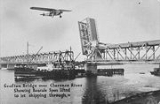
- being widened from 4 lanes to 6 lanes in 2007 - Grafton Bridge, New South WalesGrafton Bridge, New South WalesGrafton Bridge is a bascule bridge which spans the Clarence River in Grafton in New South Wales, Australia. Its upper level supports a two way road for traffic, and its lower level supports a rail bridge, a water main, and two footbridges on either side. The bascule span was operational until 1969...
- Grafton, New South WalesGrafton, New South WalesThe city of Grafton is the commercial hub of the Clarence River Valley. Established in 1851, Grafton features many historic buildings and tree-lined streets. Located approximately 630 kilometres north of Sydney and 340 km south of Brisbane, Grafton and the Clarence Valley can be reached...
rail lower deck, road upper deck - lift span out of use - Narooma Bridge - Narooma, New South WalesNarooma, New South WalesNarooma is a town in the Australian state of New South Wales on the far south coast. The town is on the Princes Highway. The name is said to be derived from the Aboriginal word meaning ‘clear blue waters’. At the 2006 census, Narooma had a population of 3,100 people.Montague Island, a National...
, still in use in 2005 - Carrathool Bridge - Carrathool , New South Wales, across the Murrumbidgee RiverMurrumbidgee RiverThe Murrumbidgee River is a major river in the state of New South Wales, Australia, and the Australian Capital Territory . A major tributary of the Murray River, the Murrumbidgee flows in a west-northwesterly direction from the foot of Peppercorn Hill in the Fiery Range of the Snowy Mountains,...
- the last surviving example of a particular type of bascule lift span http://www.rta.com.au/cgi-bin/index.cgi?action=heritage.show&id=4300165 - Broadwater Bridge, New South Wales, across the Richmond River, New South Wales - built using the renovated bascule span from the demolished Barneys Point Bridge on the Tweed River, New South Wales, converted from counterweight to hydraulic ram lift.
Canada
- Johnson Street BridgeJohnson Street BridgeThe Johnson Street Bridge is a bascule bridge that spans the harbour of Victoria, British Columbia. It is commonly referred to as the "Blue Bridge" because of its distinctive blue colour....
, across the Victoria HarbourVictoria Harbour (British Columbia)Victoria Harbour is a harbour, seaport, and seaplane airport located in the Canadian city of Victoria, British Columbia. It serves as a cruise ship and ferry destination for tourists and visitors to the city and Vancouver Island. It is both a port of entry and an airport of entry for general...
VictoriaVictoria, British ColumbiaVictoria is the capital city of British Columbia, Canada and is located on the southern tip of Vancouver Island off Canada's Pacific coast. The city has a population of about 78,000 within the metropolitan area of Greater Victoria, which has a population of 360,063, the 15th most populous Canadian...
, British ColumbiaBritish ColumbiaBritish Columbia is the westernmost of Canada's provinces and is known for its natural beauty, as reflected in its Latin motto, Splendor sine occasu . Its name was chosen by Queen Victoria in 1858... - Jackknife Bascule BridgeJackknife Bascule BridgeThe Jackknife Bascule Bridge is a bascule bridge that spans the Kaministiquia River at Thunder Bay, Ontario, Canada, to link the city to Mission Island, one of two islands in the Kaministiquia River delta. The bridge was built by the Canadian Pacific Railway between August 1910 and April 1913...
, over the Kaministiquia RiverKaministiquia RiverThe Kaministiquia River is a river which empties into western Lake Superior at the city of Thunder Bay, Ontario. Kaministiquia is an Ojibwe word meaning " with islands" due to two large islands at the mouth of the river...
in Thunder BayThunder Bay-In Canada:Thunder Bay is the name of three places in the province of Ontario, Canada along Lake Superior:*Thunder Bay District, Ontario, a district in Northwestern Ontario*Thunder Bay, a city in Thunder Bay District*Thunder Bay, Unorganized, Ontario...
, OntarioOntarioOntario is a province of Canada, located in east-central Canada. It is Canada's most populous province and second largest in total area. It is home to the nation's most populous city, Toronto, and the nation's capital, Ottawa.... - Bridges 1 (Lakeshore Road Bridge), 3A (Carlton Street Bridge), 4 (Homer Bridge [Queenston Road]), 6 (Flight Locks Railway Bridge for Canadian National Railways), 19 (Main Street Bridge [Port Colborne]) and 19A (Mellanby Avenue Bridge) on the Welland CanalWelland CanalThe Welland Canal is a ship canal in Canada that extends from Port Weller, Ontario, on Lake Ontario, to Port Colborne, Ontario, on Lake Erie. As a part of the St...
. Save for Bridges 3A and 19A, all of these were built during the late 1920s as part of the Fourth Canal expansion project (1913-1932). Bridge 3A was built to replace the original Bridge 3, which was destroyed in an accident. Bridge 19A was constructed in the 1980s to alleviate traffic on Bridge 19 (both bridges lie on either end of Lock 8). Bridge 4 is a twin-leaf, Chicago-type bascule bridge, with its counterweights located under the road deck. All the other bascule bridges on the Welland Canal are single-leaf Rall-type bridges, with counterweights suspended on a frame structure over the roadway. - La Salle CausewayLa Salle CausewayThe La Salle Causeway is a causeway that allows Highway 2 to cross the Cataraqui River at Kingston, Ontario. The causeway separates Kingston's inner and outer harbours...
lift bridge - KingstonKingston, OntarioKingston, Ontario is a Canadian city located in Eastern Ontario where the St. Lawrence River flows out of Lake Ontario. Originally a First Nations settlement called "Katarowki," , growing European exploration in the 17th Century made it an important trading post...
, OntarioOntarioOntario is a province of Canada, located in east-central Canada. It is Canada's most populous province and second largest in total area. It is home to the nation's most populous city, Toronto, and the nation's capital, Ottawa.... - Cherry Street Strauss Trunnion Bascule BridgeCherry Street Strauss Trunnion Bascule BridgeThe Cherry Street Strauss Trunnion Bascule Bridge is a bascule bridge in Toronto, Ontario, Canada. Located in the industrial Port Lands area, it carries Cherry Street over the Toronto Harbour Ship Channel and opens to allow ships to access the channel and the turning basin beyond. The bridge was...
, in TorontoTorontoToronto is the provincial capital of Ontario and the largest city in Canada. It is located in Southern Ontario on the northwestern shore of Lake Ontario. A relatively modern city, Toronto's history dates back to the late-18th century, when its land was first purchased by the British monarchy from... - CN Bridge, across the Red River, Winnipeg, Manitoba (non functional)
Germany
- Bascule bridge, Potshausen, Lower Saxony, Germany
- Wolgast-Usedom Bridge, WolgastWolgastWolgast is a town in the district of Vorpommern-Greifswald, in Mecklenburg-Vorpommern, Germany. It is situated on the bank of the river Peenestrom, vis-a-vis the island of Usedom that can be accessed by road and railway via a bascule bridge...
, Mecklenburg-Vorpommern, Germany - Wiecker Bridge, GreifswaldGreifswaldGreifswald , officially, the University and Hanseatic City of Greifswald is a town in northeastern Germany. It is situated in the state of Mecklenburg-Vorpommern, at an equal distance of about from Germany's two largest cities, Berlin and Hamburg. The town borders the Baltic Sea, and is crossed...
, Mecklenburg-Vorpommern, Germany
Russia
- Volodarsky BridgeVolodarsky BridgeThe Volodarsky Bridge is a bridge across the Neva River in Saint Petersburg, Russia. The bridge connects Narodnaya and Ivanovskaya streets. The bridge length is 332 meters, the width is 24–27 meters. It is named after V. Volodarsky, a revolutionary, who was killed near the future bridge in 1918....
in Saint PetersburgSaint PetersburgSaint Petersburg is a city and a federal subject of Russia located on the Neva River at the head of the Gulf of Finland on the Baltic Sea... - Finland Railway BridgeFinland Railway BridgeThe Finland Railway Bridge are a pair of parallel bridges across the Neva River in Saint Petersburg, Russia. The bridges link the railway networks in the north of St Petersburg with those in the south of St Petersburg...
in Saint PetersburgSaint PetersburgSaint Petersburg is a city and a federal subject of Russia located on the Neva River at the head of the Gulf of Finland on the Baltic Sea... - Alexander Nevsky BridgeAlexander Nevsky BridgeThe Alexander Nevsky Bridge in St Petersburg, Russia is named after the legendary Russian military commander and politician Alexander Nevsky. The bridge connects Alexander Nevsky Square and Zanevsky prospect thus linking the southern and the northern parts of the city...
in Saint PetersburgSaint PetersburgSaint Petersburg is a city and a federal subject of Russia located on the Neva River at the head of the Gulf of Finland on the Baltic Sea... - Peter the Great BridgePeter the Great BridgeBolsheokhtinsky Bridge is a bridge across the Neva River in Saint Petersburg, Russia. The bridge's length is 334 meters, the width is 23 meters. The bridge features only three spans, the central one can be drawn.-History:...
in Saint PetersburgSaint PetersburgSaint Petersburg is a city and a federal subject of Russia located on the Neva River at the head of the Gulf of Finland on the Baltic Sea... - Liteyny BridgeLiteyny BridgeThe Liteyny Bridge is the second permanent bridge across the Neva river in Saint Petersburg, Russia. It connects Liteyny Prospekt with Vyborgsky district. The bridge's length is 396 meters, the width is 34 meters...
in Saint PetersburgSaint PetersburgSaint Petersburg is a city and a federal subject of Russia located on the Neva River at the head of the Gulf of Finland on the Baltic Sea... - Trinity Bridge in Saint PetersburgSaint PetersburgSaint Petersburg is a city and a federal subject of Russia located on the Neva River at the head of the Gulf of Finland on the Baltic Sea...
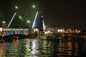
- Palace BridgePalace BridgePalace Bridge is a road traffic and foot bascule bridge spanning the Neva River in Saint Petersburg between Palace Square and Vasilievsky Island. Like every other Neva bridge , it is drawn by night, making foot travel between various parts of the city virtually impossible...
in Saint PetersburgSaint PetersburgSaint Petersburg is a city and a federal subject of Russia located on the Neva River at the head of the Gulf of Finland on the Baltic Sea... - Blagoveshchensky Bridge in Saint PetersburgSaint PetersburgSaint Petersburg is a city and a federal subject of Russia located on the Neva River at the head of the Gulf of Finland on the Baltic Sea...
- Exchange BridgeExchange BridgeBirzhevoy Bridge is the bridge across Malaya Neva in Saint Petersburg, Russia. Its length is 239 meters and width is 27 meters. Birzhevoy bridge connects Vasilievsky Island and Petrogradsky Island...
in Saint PetersburgSaint PetersburgSaint Petersburg is a city and a federal subject of Russia located on the Neva River at the head of the Gulf of Finland on the Baltic Sea... - Tuchkov BridgeTuchkov BridgeTuchkov Bridge is the bridge across Malaya Neva in Saint Petersburg, Russia. Its length is 226 meters and its width is 36 meters. Tuchkov bridge connects Vasilievsky Island and Petrogradsky Island....
in Saint PetersburgSaint PetersburgSaint Petersburg is a city and a federal subject of Russia located on the Neva River at the head of the Gulf of Finland on the Baltic Sea... - Sampsonievsky Bridge in Saint PetersburgSaint PetersburgSaint Petersburg is a city and a federal subject of Russia located on the Neva River at the head of the Gulf of Finland on the Baltic Sea...
- Grenader Bridge in Saint PetersburgSaint PetersburgSaint Petersburg is a city and a federal subject of Russia located on the Neva River at the head of the Gulf of Finland on the Baltic Sea...
- Kantemirovsky Bridge in Saint PetersburgSaint PetersburgSaint Petersburg is a city and a federal subject of Russia located on the Neva River at the head of the Gulf of Finland on the Baltic Sea...
South Africa
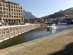
- At the Victoria & Alfred WaterfrontVictoria & Alfred WaterfrontThe Victoria & Alfred Waterfront in the historic heart of Cape Town's working harbour is South Africa's most-visited destination, having the highest rate of foreign tourists of any attraction in the country...
in Cape TownCape TownCape Town is the second-most populous city in South Africa, and the provincial capital and primate city of the Western Cape. As the seat of the National Parliament, it is also the legislative capital of the country. It forms part of the City of Cape Town metropolitan municipality...
United Kingdom
- Sutton Road Bridge, Kingston upon HullKingston upon HullKingston upon Hull , usually referred to as Hull, is a city and unitary authority area in the ceremonial county of the East Riding of Yorkshire, England. It stands on the River Hull at its junction with the Humber estuary, 25 miles inland from the North Sea. Hull has a resident population of...
- North Bridge, Kingston upon HullKingston upon HullKingston upon Hull , usually referred to as Hull, is a city and unitary authority area in the ceremonial county of the East Riding of Yorkshire, England. It stands on the River Hull at its junction with the Humber estuary, 25 miles inland from the North Sea. Hull has a resident population of...
- Tower BridgeTower BridgeTower Bridge is a combined bascule and suspension bridge in London, England, over the River Thames. It is close to the Tower of London, from which it takes its name...
, LondonLondonLondon is the capital city of :England and the :United Kingdom, the largest metropolitan area in the United Kingdom, and the largest urban zone in the European Union by most measures. Located on the River Thames, London has been a major settlement for two millennia, its history going back to its... - Renfrew Swing Bridge (misnomerMisnomerA misnomer is a term which suggests an interpretation that is known to be untrue. Such incorrect terms sometimes derive their names because of the form, action, or origin of the subject becoming named popularly or widely referenced—long before their true natures were known.- Sources of misnomers...
), RenfrewRenfrew-Local government:The town of Renfrew gave its name to a number of local government areas used at various times:*Renfrew a town to the west of Glasgow*Renfrewshire, the present unitary local council area in which Renfrew is situatated.... - LowestoftLowestoftLowestoft is a town in the English county of Suffolk. The town is on the North Sea coast and is the most easterly point of the United Kingdom. It is north-east of London, north-east of Ipswich and south-east of Norwich...
Bascule Bridge, WaveneyWaveneyWaveney is a local government district in Suffolk, England, named after the River Waveney that forms its north-west border. The district council is based in Lowestoft, the major settlement in Waveney, which is the only unparished area in the district... - Pero's BridgePero's BridgePero's Bridge is a pedestrian, bascule bridge at St Augustine's Reach in Bristol Harbour. It links Queen Square and Millennium Square.- Structure :...
, BristolBristolBristol is a city, unitary authority area and ceremonial county in South West England, with an estimated population of 433,100 for the unitary authority in 2009, and a surrounding Larger Urban Zone with an estimated 1,070,000 residents in 2007... - Redcliffe Bascule Bridge, Bristol
- Town Bridge, across Weymouth Harbour, Dorset.
- Countess Wear Bascule Bridge, Exeter CanalExeter CanalThe Exeter Ship Canal, sometimes just called the Exeter Canal, downstream of Exeter, Devon, England was built in the 1560s which means it pre-dates the "canal mania" period and is one of the oldest artificial waterways in the UK.-History:...
, ExeterExeterExeter is a historic city in Devon, England. It lies within the ceremonial county of Devon, of which it is the county town as well as the home of Devon County Council. Currently the administrative area has the status of a non-metropolitan district, and is therefore under the administration of the... - River Bann Rail Bridge, Coleraine, Northern Ireland
- King George V BridgeKeadby BridgeKeadby Bridge, more formally known as the King George V Bridge, crosses the River Trent near Althorpe and Keadby in Lincolnshire.-History:...
, KeadbyKeadbyKeadby is a small village lying just off the A18, west of Scunthorpe, in North Lincolnshire, England. It lies on the West bank of the River Trent. It is pronounced "Kidby".... - Walney BridgeWalney BridgeWalney Bridge is a bridge in Cumbria, England that connects Barrow-in-Furness on the British mainland to Walney Island.-History:...
, Barrow-in-FurnessBarrow-in-FurnessBarrow-in-Furness is an industrial town and seaport which forms about half the territory of the wider Borough of Barrow-in-Furness in the county of Cumbria, England. It lies north of Liverpool, northwest of Manchester and southwest from the county town of Carlisle...
United States
(Alphabetical by State)- Mystic River Bascule BridgeMystic River Bascule BridgeThe Mystic River Bascule Bridge is a bascule bridge, a type of drawbridge with counterweights, that spans the Mystic River in Mystic, Connecticut in the United States....
, Mystic, Connecticut - Pequonnock River Railroad BridgePequonnock River Railroad BridgeThe Pequonnock River Railroad Bridge is a railroad drawbridge over the Pequonnock River in Bridgeport, Connecticut. Owned by the State of Connecticut and maintained and operated by Metro-North Railroad, it is also referred to as Pequonnock River Bridge, PECK Bridge, and Undergrade Bridge 55.90...
, Bridgeport, Connecticut - Thames River Bridge between New London and Groton, Connecticut. (to be replaced with a vertical lift finishing 2008)
- Washington BridgeWashington Bridge (Connecticut)The Washington Bridge carries U.S. Route 1 over the Housatonic River in the U.S. state of Connecticut, connecting the city of Milford to the town of Stratford. Its geographic location is N 41.20037 by W -73.11039...
, US Route 1, Milford & Stratford Connecticut - Market Street BridgeSouth Market Street Bridge (Wilmington)The South Market Street Bridge, officially the Senator John E. Reilly, Sr. Bridge, is a bascule bridge that spans the Christina River in Wilmington, Delaware....
, Wilmington, Delaware - Highway 204 Bridge, Skidaway Narrows, Georgia
- Sam Vardendoe Bridge, Causton Bluff, Georgia
- Various bridges across the Intracoastal WaterwayIntracoastal WaterwayThe Intracoastal Waterway is a 3,000-mile waterway along the Atlantic and Gulf coasts of the United States. Some lengths consist of natural inlets, salt-water rivers, bays, and sounds; others are artificial canals...
in FloridaFloridaFlorida is a state in the southeastern United States, located on the nation's Atlantic and Gulf coasts. It is bordered to the west by the Gulf of Mexico, to the north by Alabama and Georgia and to the east by the Atlantic Ocean. With a population of 18,801,310 as measured by the 2010 census, it...
. - Various bridges across the Miami RiverMiami River (Florida)The Miami River is a river in the United States state of Florida that drains out of the Everglades and runs through the Downtown and the city of Miami. The long river flows from the terminus of the Miami Canal at Miami International Airport to Biscayne Bay...
in Miami, FloridaMiami, FloridaMiami is a city located on the Atlantic coast in southeastern Florida and the county seat of Miami-Dade County, the most populous county in Florida and the eighth-most populous county in the United States with a population of 2,500,625...
. - St. Charles Air Line BridgeSt. Charles Air Line BridgeThe St. Charles Air Line Bridge is a Strauss Trunnion bascule bridge which spans the Chicago River in Chicago, Illinois.Built as part of the St. Charles Air Line Railroad by the American Bridge Company in 1919, the bridge originally had a span of 260 feet ...
, as well as many other bridges across the Chicago River, ChicagoChicagoChicago is the largest city in the US state of Illinois. With nearly 2.7 million residents, it is the most populous city in the Midwestern United States and the third most populous in the US, after New York City and Los Angeles...
, IllinoisIllinoisIllinois is the fifth-most populous state of the United States of America, and is often noted for being a microcosm of the entire country. With Chicago in the northeast, small industrial cities and great agricultural productivity in central and northern Illinois, and natural resources like coal,... - Franklin Street Bridge in Michigan City, IndianaMichigan City, IndianaMichigan City's origins date to 1830, when the land for the city was first purchased by Isaac C. Elston. Elston Middle School, formerly Elston High School, located at 317 Detroit St., is named after the founder....
http://wikimapia.org/581579/Franklin-Street-Bridge - St. Claude Avenue BridgeSt. Claude Avenue BridgeThe St. Claude Avenue Bridge is a bascule bridge with four vehicular lanes over the Industrial Canal in New Orleans, Louisiana. This was originally a combination railroad and automobile bridge, with two pairs of railroad tracks in the center of the lift span and automobile lanes straddling it...
. New Orleans, LouisianaNew Orleans, LouisianaNew Orleans is a major United States port and the largest city and metropolitan area in the state of Louisiana. The New Orleans metropolitan area has a population of 1,235,650 as of 2009, the 46th largest in the USA. The New Orleans – Metairie – Bogalusa combined statistical area has a population... - Maestri BridgeMaestri BridgeThe Maestri Bridge carries U.S. Route 11 across Lake Pontchartrain between New Orleans and Slidell, Louisiana. The bridge opened on February 18, 1928 as the first permanent crossing of Lake Pontchartrain...
, between New Orleans, LouisianaNew Orleans, LouisianaNew Orleans is a major United States port and the largest city and metropolitan area in the state of Louisiana. The New Orleans metropolitan area has a population of 1,235,650 as of 2009, the 46th largest in the USA. The New Orleans – Metairie – Bogalusa combined statistical area has a population...
and Slidell, LouisianaSlidell, LouisianaSlidell is a city situated on the northeast shore of Lake Pontchartrain in St. Tammany Parish, Louisiana, United States. The population was 25,695 at the 2000 census. The Greater Slidell Community has a population of about 90,000... - Lake Pontchartrain CausewayLake Pontchartrain CausewayThe Lake Pontchartrain Causeway, or the Causeway, consists of two parallel bridges crossing Lake Pontchartrain in southern Louisiana, United States. The longer of the two bridges is long...
on Lake PontchartrainLake PontchartrainLake Pontchartrain is a brackish estuary located in southeastern Louisiana. It is the second-largest inland saltwater body of water in the United States, after the Great Salt Lake in Utah, and the largest lake in Louisiana. As an estuary, Pontchartrain is not a true lake.It covers an area of with...
in LouisianaLouisianaLouisiana is a state located in the southern region of the United States of America. Its capital is Baton Rouge and largest city is New Orleans. Louisiana is the only state in the U.S. with political subdivisions termed parishes, which are local governments equivalent to counties...
. - Million Dollar Bridge (Maine)Million Dollar Bridge (Maine)The Million Dollar Bridge was a bascule bridge built in 1916 which carried traffic on Route 77 over the Fore River in Maine between Portland and South Portland....
, Portland, Maine (demolished) - Casco Bay BridgeCasco Bay BridgeThe Casco Bay Bridge is a bascule bridge that spans the Fore River, connecting South Portland and Portland, Maine, USA.-History:In 1987 the state of Maine, in concert with surrounding towns, concluded that the existing Million Dollar Bridge, which was almost 70 years old, was inadequate for current...
, Portland, Maine - Brightman Street BridgeBrightman Street BridgeThe Brightman Street Bridge is a long, four-lane wide drawbridge spanning the Taunton River between the town of Somerset and the city of Fall River, Massachusetts. It was authorized in 1903 by the state legislature, and building took place between 1906 and 1908, when it opened full time on...
, Fall River, MassachusettsFall River, MassachusettsFall River is a city in Bristol County, Massachusetts, in the United States. It is located about south of Boston, southeast of Providence, Rhode Island, and west of New Bedford and south of Taunton. The city's population was 88,857 during the 2010 census, making it the tenth largest city in... - Maple Street Bridge, Manistee, Michigan
- Cypress Street Bridge, Manistee, Michigan
- Independence BridgeIndependence BridgeThe Independence Bridge is a drawbridge located in Bay City, Michigan. It carries Truman Parkway over the Saginaw River and was opened in 1973 to replace the earlier Belinda Street Bridge -External links:*...
, Bay City, Michigan - Lafayette Avenue BridgeLafayette Avenue BridgeThe Lafayette Avenue Bridge is a set of two small bridges located in Bay City, Michigan. It carries M-13 and M-84 over the Saginaw River. It is maintained by the Michigan Department of Transportation, and is the oldest of four drawbridges in Bay City....
, Bay City, Michigan - Liberty BridgeLiberty Bridge (Bay City, Michigan)The Liberty Bridge is a drawbridge located in Bay City, Michigan. It spans the Saginaw River and connects Vermont Street and Woodside Avenue ....
, Bay City, Michigan - Veterans Memorial BridgeVeterans Memorial Bridge (Bay City, Michigan)The Veterans Memorial Bridge is a drawbridge located in Bay City, Michigan. It carries Michigan Route M-25 over the Saginaw River. Its location is just south of Wenona Park , and Veteran's Park . The Veterans Memorial Bridge opened in 1957, the same year as the Mackinac Bridge...
, Bay City, Michigan - Ferry Street Bridge, Buffalo, New York http://www.buffaloah.com/a/water/ferry/index.html
- Col. Patrick O'Rorke Bridge in Rochester, NY http://www.bergmannpc.com/structures/mov_bridges/ororke.html
- Pasquotank River Bridge, Elizabeth City, North Carolina http://www.ncdot.org/doh/operations/dp_chief_eng/maintenance/bridge/pasquotank.html
- CSX Transportation Bridge, Wilmington, North Carolina
- Ashtabula lift bridgeAshtabula lift bridgeThe Ashtabula lift bridge is a Strauss bascule bridge that carries Ohio State Route 531 over the Ashtabula River in the harbor of Ashtabula, Ohio. Built in 1925, it is one of only two of its type that remain in service in the state of Ohio. In 1985 it was listed on the National Register of...
Ashtabula, Ohio - Charles Berry BridgeCharles Berry BridgeThe Charles Berry Bridge, in Lorain, Ohio along U.S. Route 6, is the second-largest bascule bridge in the world. It was dedicated on Veterans Day in 1988. The bridge had been built in the late 1930s and in use for roughly 48 years before extensive rehabilitation was finished and the bridge was...
Lorain, Ohio - Broadway BridgeBroadway Bridge (Portland)The Broadway Bridge is a bascule bridge that spans the Willamette River in Portland, Oregon, U.S. It was the first bascule bridge built in Portland and the longest in the world at the time of its completion. It is the longest Rall-type bascule bridge still in existence.-History and description:The...
, Portland, Oregon - Burnside BridgeBurnside BridgeThe Burnside Bridge is a bascule bridge that spans the Willamette River in Portland, Oregon.-Design:Including approaches, the Burnside has a total length of and a center span. While lowered this span is normally above the river. The deck is made of concrete, which contributes to its being one of...
, Portland, Oregon - Morrison BridgeMorrison BridgeThe Morrison Bridge is a bascule bridge that spans the Willamette River in Portland, Oregon.The original Morrison Bridge was a wooden truss swing span bridge completed on April 12, 1887 as the first Willamette River bridge in Portland and the longest bridge west of the Mississippi River...
, Portland, Oregon - Tacony-Palmyra BridgeTacony-Palmyra BridgeThe Tacony–Palmyra Bridge is a combination steel arch, double-leaf bascule bridge across the Delaware River, connecting New Jersey Route 73 in Palmyra, New Jersey and Pennsylvania Route 73 in the Tacony section of Philadelphia. The bridge has a total length of 3,659 feet and spans 2,324 feet . It...
, Philadelphia, Pennsylvania - John Ross Bridge http://upload.wikimedia.org/wikipedia/commons/c/c7/Tennesseeriverbridge.JPG, Chattanooga, Tennessee (closed for repairs from 19 September 2005 until late 2007).
- First Avenue South BridgeFirst Avenue South BridgeThe First Avenue South Bridge is a pair of double-leaf bascule bridges built between 1956 and 1998 that carry State Route 99 over the Duwamish River about three miles south of downtown Seattle, Washington....
, Seattle, Washington - Montlake BridgeMontlake BridgeThe Montlake Bridge is a double-leaf bascule bridge that carries Montlake Boulevard over Seattle's Montlake Cut--part of the Lake Washington Ship Canal--connecting Montlake and the University District....
, Seattle, Washington - University Bridge, Seattle, Washington
- Fremont Bridge, Seattle, Washington
- Ballard BridgeBallard BridgeThe Ballard Bridge, also known as the 15th Avenue Bridge, is a double-leaf bascule bridge in Seattle, Washington, United States. It carries 15th Avenue NW over Seattle's Salmon Bay between Ballard and Interbay. Built in 1917, it has an opening span of and a total length of . It was added to the...
, Seattle, Washington - Salmon Bay Bridge, Seattle, Washington
- Woodrow Wilson BridgeWoodrow Wilson BridgeThe Woodrow Wilson Memorial Bridge is a bascule bridge that spans the Potomac River between the independent city of Alexandria, Virginia and Oxon Hill in Prince George's County, Maryland, United States. While over the water near the Virginia shore, it crosses the southern tip of the District of...
, Alexandria, Virginia - Washington, DC - Prince George's County, Maryland