
Kaministiquia River
Encyclopedia
The Kaministiquia River is a river
which empties into western Lake Superior
at the city of Thunder Bay
, Ontario
. Kaministiquia (Gaa-ministigweyaa) is an Ojibwe
word meaning "(river) with islands" due to two large islands (McKellar and Mission) at the mouth of the river. The delta
has three branches or outlets: the southernmost is known as the Mission River, the central branch as the McKellar River, and the northernmost branch as the Kaministiquia. Residents of the region commonly refer to the river as the Kam River.
located on this river is the largest waterfall in the Lake Superior watershed at a height of 39 metres (128 ft). Below these falls, the river flows through an extensive floodplain created by an ancient predecessor that flowed through this region following the last ice age
.
Tributaries of the Kaministiquia include the:
, this river was an important part of the water route into western Canada. During the French regime, two fur trading posts were established at the delta of the Kaministiquia, the first by Daniel Greysolon, sieur Dulhut (1684/85-1696) and a second one in 1717 by Zacharie Robutel de la Noue, both now usually referred to as (Fort Kaministiquia
)) because of the large number of variant spellings used during the French regime, such as Kamanistigouian, Camanistigoyan, Kaministigoyan, etc. A British trading post of Fort William, Ontario
was established here in 1803 by the North West Company
at the river's mouth, and another upstream at Point de Meuron by the Hudson's Bay Company
. The two rival British posts were amalgamated in 1821. The river has has had many spellings since 1681, finally being spelled as Kaministiquia, although for a time Kaministikwia was also an official spelling.
Following the opening of the American canal at Sault Ste Marie in 1855, the river became more accessible to navigation. Silt
had created a sand bar at its principal mouth, such that dredging was required as early as 1873 to enable larger boats to venture farther upstream.
After 1883, the lower Kaministiquia river was heavily industrialized by the Canadian Pacific Railway
with railway yards, coal yards and docks, grain elevators, shipping docks, and sawmills. The double-deck Jackknife Bascule Bridge
was built by the CPR in 1913 to allow trains and vehicles to cross from the mainland to Mission Island. The Thunder Bay Generating Station
is located on Mission Island in the river's delta. The three branches of the river at the delta were extensively dredged and widened by the federal Department of Public Works in the early twentieth century to facilitate navigation.
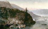
The river has been depicted by many prominent Canadian artists such as William Armstrong
(1822–1914), Frances Anne Hopkins
(The Red River Expedition at Kakabeka Falls, 1877) and Lucius Richard O'Brien
(Kakabeka Falls, 1882).
route from Fort William 135 miles west to the juncture of the Grand Portage route at Lac La Croix. For background see Canadian canoe routes (early)
. The Kaministiquia and Grand Portage were the two main routes used by Canadian fur traders travel to western Canada from the Great Lakes. The Kaministiquia route was first used in 1688 by Jacques de Noyon
. About 1731 La Vérendrye
used Grand Portage which became the preferred route. Since it was impractical for western traders to make a round trip to Montreal in one season, they would go to Grand Portage and exchange goods with boats that had come up from Montreal. By 1803 it was found that Grand Portage was on the US side of the border and the route was moved 40 miles northeast to Fort William.
The canoe route ran west from Fort William with only one decharge to Kakabeka Falls
, which was passed by the Mountain Portage. The Northwest Company soon built a road to a depot above the falls. From here north up a swift stretch with at least seven portages, and then some more portages and significant altitude gain to Dog Lake (Ontario)
about 25 miles northwest of Fort William. Then an easy 50 miles northwest up the twisting Dog River (Ontario)
, Jordain Creek and Cold Water Creek to Cold Water Lake. Then began a difficult boggy stretch west through the 3-mile Prairie Portage, Height of Land Lake, the half-mile De Milieu Portage, Lac de Milieu, the mile-and-a-half Savanne Portage to the Savanne River in the Lake Winnipeg drainage. Then west down the Savanne to Lac des Mille Lacs. Since the Seine River (Ontario)
is too rough for freight canoes, the route went over the quarter-mile Baril Portage to the Pickerel River and Pickerel Lake, the Pickerel and Deux Rivières Portages to Sturgeon Lake and down the Maligne River to Lac La Croix where the route from Grand Portage came in from the southeast. For the route west from Lac La Croix see Canadian canoe routes (early)
.
River
A river is a natural watercourse, usually freshwater, flowing towards an ocean, a lake, a sea, or another river. In a few cases, a river simply flows into the ground or dries up completely before reaching another body of water. Small rivers may also be called by several other names, including...
which empties into western Lake Superior
Lake Superior
Lake Superior is the largest of the five traditionally-demarcated Great Lakes of North America. It is bounded to the north by the Canadian province of Ontario and the U.S. state of Minnesota, and to the south by the U.S. states of Wisconsin and Michigan. It is the largest freshwater lake in the...
at the city of Thunder Bay
Thunder Bay
-In Canada:Thunder Bay is the name of three places in the province of Ontario, Canada along Lake Superior:*Thunder Bay District, Ontario, a district in Northwestern Ontario*Thunder Bay, a city in Thunder Bay District*Thunder Bay, Unorganized, Ontario...
, Ontario
Ontario
Ontario is a province of Canada, located in east-central Canada. It is Canada's most populous province and second largest in total area. It is home to the nation's most populous city, Toronto, and the nation's capital, Ottawa....
. Kaministiquia (Gaa-ministigweyaa) is an Ojibwe
Ojibwe language
Ojibwe , also called Anishinaabemowin, is an indigenous language of the Algonquian language family. Ojibwe is characterized by a series of dialects that have local names and frequently local writing systems...
word meaning "(river) with islands" due to two large islands (McKellar and Mission) at the mouth of the river. The delta
River delta
A delta is a landform that is formed at the mouth of a river where that river flows into an ocean, sea, estuary, lake, reservoir, flat arid area, or another river. Deltas are formed from the deposition of the sediment carried by the river as the flow leaves the mouth of the river...
has three branches or outlets: the southernmost is known as the Mission River, the central branch as the McKellar River, and the northernmost branch as the Kaministiquia. Residents of the region commonly refer to the river as the Kam River.
Geography
Kakabeka FallsKakabeka Falls
Kakabeka Falls Provincial Park, established in 1955, covers 5 km² and is managed by Ontario Parks. It surrounds the falls and extends along the Kaministiquia River, which was used centuries ago by Voyageurs, who were the first Europeans to overwinter annually in northern Ontario...
located on this river is the largest waterfall in the Lake Superior watershed at a height of 39 metres (128 ft). Below these falls, the river flows through an extensive floodplain created by an ancient predecessor that flowed through this region following the last ice age
Ice age
An ice age or, more precisely, glacial age, is a generic geological period of long-term reduction in the temperature of the Earth's surface and atmosphere, resulting in the presence or expansion of continental ice sheets, polar ice sheets and alpine glaciers...
.
Tributaries of the Kaministiquia include the:
- Dog RiverDog River (Ontario)Dog River is a river located northwest of Thunder Bay, Ontario, Canada. It enters the northern end of Big Dog Lake and drains at the southern end, continuing to Little Dog Lake and then to its confluence with the Matawin River to form Kaministiquia River. The name "Kaministiquia" comes from an...
- Matawin River
- Whitefish River
History
"Kamanistigouian," as a place, is first mentioned in a decree of the Conseil Souverain de la Nouvelle-France dated 23 August 1681 instructing one of two canoes to make known the king's amnesty to coureurs de bois, although the still unnamed river is depicted on the 1671 "Carte des Jésuites" as "R. [rivière] par où l'on va aux Assinipoualacs à 120 lieues vers le Nord-Ouest." (River by which one travels to the Assinipoualacs 120 leagues to the north-west) Like the Pigeon RiverPigeon River (Minnesota-Ontario)
The Pigeon River forms part of the US-Canada border between the State of Minnesota and the Province of Ontario west of Lake Superior. In pre-industrial times the river was a waterway of great importance for transportation and trade.-Geography:...
, this river was an important part of the water route into western Canada. During the French regime, two fur trading posts were established at the delta of the Kaministiquia, the first by Daniel Greysolon, sieur Dulhut (1684/85-1696) and a second one in 1717 by Zacharie Robutel de la Noue, both now usually referred to as (Fort Kaministiquia
Fort Kaministiquia
Fort Camanistigoyan, now standardized as Fort Kaministiquia, located at the mouth of the Kaministiquia River on Lake Superior in what is now northwestern Ontario, Canada, was established in 1717 by Zacharie Robutel de la Noue following the restoration of the system of trading permits by...
)) because of the large number of variant spellings used during the French regime, such as Kamanistigouian, Camanistigoyan, Kaministigoyan, etc. A British trading post of Fort William, Ontario
Fort William, Ontario
Fort William was a city in Northern Ontario, located on the Kaministiquia River, at its entrance to Lake Superior. It amalgamated with Port Arthur and the townships of Neebing and McIntyre to form the city of Thunder Bay in January 1970. Ever since then it has been the largest city in Northwestern...
was established here in 1803 by the North West Company
North West Company
The North West Company was a fur trading business headquartered in Montreal from 1779 to 1821. It competed with increasing success against the Hudson's Bay Company in what was to become Western Canada...
at the river's mouth, and another upstream at Point de Meuron by the Hudson's Bay Company
Hudson's Bay Company
The Hudson's Bay Company , abbreviated HBC, or "The Bay" is the oldest commercial corporation in North America and one of the oldest in the world. A fur trading business for much of its existence, today Hudson's Bay Company owns and operates retail stores throughout Canada...
. The two rival British posts were amalgamated in 1821. The river has has had many spellings since 1681, finally being spelled as Kaministiquia, although for a time Kaministikwia was also an official spelling.
Following the opening of the American canal at Sault Ste Marie in 1855, the river became more accessible to navigation. Silt
Silt
Silt is granular material of a size somewhere between sand and clay whose mineral origin is quartz and feldspar. Silt may occur as a soil or as suspended sediment in a surface water body...
had created a sand bar at its principal mouth, such that dredging was required as early as 1873 to enable larger boats to venture farther upstream.
After 1883, the lower Kaministiquia river was heavily industrialized by the Canadian Pacific Railway
Canadian Pacific Railway
The Canadian Pacific Railway , formerly also known as CP Rail between 1968 and 1996, is a historic Canadian Class I railway founded in 1881 and now operated by Canadian Pacific Railway Limited, which began operations as legal owner in a corporate restructuring in 2001...
with railway yards, coal yards and docks, grain elevators, shipping docks, and sawmills. The double-deck Jackknife Bascule Bridge
Jackknife Bascule Bridge
The Jackknife Bascule Bridge is a bascule bridge that spans the Kaministiquia River at Thunder Bay, Ontario, Canada, to link the city to Mission Island, one of two islands in the Kaministiquia River delta. The bridge was built by the Canadian Pacific Railway between August 1910 and April 1913...
was built by the CPR in 1913 to allow trains and vehicles to cross from the mainland to Mission Island. The Thunder Bay Generating Station
Thunder Bay Generating Station
The Thunder Bay Generating Station is a coal fired station owned by Ontario Power Generation, located on Mission Island on the shore of Thunder Bay, an inlet of Lake Superior. The plant provides energy to parts of Thunder Bay District in Northwestern Ontario....
is located on Mission Island in the river's delta. The three branches of the river at the delta were extensively dredged and widened by the federal Department of Public Works in the early twentieth century to facilitate navigation.
The river has been depicted by many prominent Canadian artists such as William Armstrong
William Armstrong (artist)
William Armstrong was a Canadian artist and one of the early professional artists of Toronto. A number of his watercolour landscapes of the Great Lakes may be found in collections such as the Art Gallery of Ontario, the National Gallery of Canada, and the Thunder Bay Historical Museum...
(1822–1914), Frances Anne Hopkins
Frances Anne Hopkins
Frances Anne Hopkins, , daughter of Frederick William Beechey was born in England and had a talent for painting. In 1858, she married a Hudson's Bay Company official, Edward Hopkins, whose work took him to North America. She accompanied him and travelled extensively by canoe along some of the most...
(The Red River Expedition at Kakabeka Falls, 1877) and Lucius Richard O'Brien
Lucius Richard O'Brien
Lucius Richard O'Brien was an influential 19th-century Canadian oil and watercolour landscape artist.-Life and career:...
(Kakabeka Falls, 1882).
Voyageur Route
This section covers the voyageurVoyageur
Voyageur is a French word meaning "voyager" or "traveler".Voyageur can refer to:*Voyageurs, persons who transported furs by canoe during the fur trade era....
route from Fort William 135 miles west to the juncture of the Grand Portage route at Lac La Croix. For background see Canadian canoe routes (early)
Canadian canoe routes (early)
This article covers the water routes used by early explorers of Canada with special emphasis on the fur trade.-Canada and Siberia:Both Canada and Siberia were explored mainly by river. Both countries have many navigable rivers with short portages between them. There are no serious barriers to canoe...
. The Kaministiquia and Grand Portage were the two main routes used by Canadian fur traders travel to western Canada from the Great Lakes. The Kaministiquia route was first used in 1688 by Jacques de Noyon
Jacques de Noyon
Jacques de Noyon was a French Canadian explorer and coureur des bois. He is the first known European to visit the Boundary Waters region west of Lake Superior.Jacques de Noyon was born on February 12, 1668, in Trois-Rivières, New France...
. About 1731 La Vérendrye
Pierre Gaultier de Varennes, sieur de La Vérendrye
Pierre Gaultier de Varennes, sieur de La Vérendrye was a French Canadian military officer, fur trader and explorer. In the 1730s he and his four sons opened up the area west of Lake Superior and thus began the process that added Western Canada to the original New France in the Saint Lawrence basin...
used Grand Portage which became the preferred route. Since it was impractical for western traders to make a round trip to Montreal in one season, they would go to Grand Portage and exchange goods with boats that had come up from Montreal. By 1803 it was found that Grand Portage was on the US side of the border and the route was moved 40 miles northeast to Fort William.
The canoe route ran west from Fort William with only one decharge to Kakabeka Falls
Kakabeka Falls
Kakabeka Falls Provincial Park, established in 1955, covers 5 km² and is managed by Ontario Parks. It surrounds the falls and extends along the Kaministiquia River, which was used centuries ago by Voyageurs, who were the first Europeans to overwinter annually in northern Ontario...
, which was passed by the Mountain Portage. The Northwest Company soon built a road to a depot above the falls. From here north up a swift stretch with at least seven portages, and then some more portages and significant altitude gain to Dog Lake (Ontario)
Dog Lake (Ontario)
Dog Lake is a lake in northwestern Ontario, Canada which drains south through the Kaministiquia River to Thunder Bay on Lake Superior. It was on the voyageur route to western Canada. Its name comes from a large aboriginal effigy of a dog on a nearby hill. The lake is primarily fed by Dog River...
about 25 miles northwest of Fort William. Then an easy 50 miles northwest up the twisting Dog River (Ontario)
Dog River (Ontario)
Dog River is a river located northwest of Thunder Bay, Ontario, Canada. It enters the northern end of Big Dog Lake and drains at the southern end, continuing to Little Dog Lake and then to its confluence with the Matawin River to form Kaministiquia River. The name "Kaministiquia" comes from an...
, Jordain Creek and Cold Water Creek to Cold Water Lake. Then began a difficult boggy stretch west through the 3-mile Prairie Portage, Height of Land Lake, the half-mile De Milieu Portage, Lac de Milieu, the mile-and-a-half Savanne Portage to the Savanne River in the Lake Winnipeg drainage. Then west down the Savanne to Lac des Mille Lacs. Since the Seine River (Ontario)
Seine River (Ontario)
The Seine River is a river in Kenora, Rainy River and Thunder Bay Districts in northwestern Ontario, Canada. It flows from Lac des Mille Lacs to Rainy Lake....
is too rough for freight canoes, the route went over the quarter-mile Baril Portage to the Pickerel River and Pickerel Lake, the Pickerel and Deux Rivières Portages to Sturgeon Lake and down the Maligne River to Lac La Croix where the route from Grand Portage came in from the southeast. For the route west from Lac La Croix see Canadian canoe routes (early)
Canadian canoe routes (early)
This article covers the water routes used by early explorers of Canada with special emphasis on the fur trade.-Canada and Siberia:Both Canada and Siberia were explored mainly by river. Both countries have many navigable rivers with short portages between them. There are no serious barriers to canoe...
.