
Lake Pontchartrain Causeway
Overview
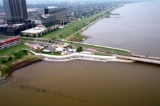
Causeway
In modern usage, a causeway is a road or railway elevated, usually across a broad body of water or wetland.- Etymology :When first used, the word appeared in a form such as “causey way” making clear its derivation from the earlier form “causey”. This word seems to have come from the same source by...
, consists of two parallel bridges crossing Lake Pontchartrain
Lake Pontchartrain
Lake Pontchartrain is a brackish estuary located in southeastern Louisiana. It is the second-largest inland saltwater body of water in the United States, after the Great Salt Lake in Utah, and the largest lake in Louisiana. As an estuary, Pontchartrain is not a true lake.It covers an area of with...
in southern Louisiana
Louisiana
Louisiana is a state located in the southern region of the United States of America. Its capital is Baton Rouge and largest city is New Orleans. Louisiana is the only state in the U.S. with political subdivisions termed parishes, which are local governments equivalent to counties...
, United States
United States
The United States of America is a federal constitutional republic comprising fifty states and a federal district...
. The longer of the two bridges is 23.83 miles (38.35 km) long. Since 1969 it was listed by Guinness World Records
Guinness World Records
Guinness World Records, known until 2000 as The Guinness Book of Records , is a reference book published annually, containing a collection of world records, both human achievements and the extremes of the natural world...
as the longest bridge over water in the world; in 2011 in response to the opening of the longer Jiaozhou Bay Bridge in China, Guinness created two categories for bridges over water: continuous and aggregate lengths over water.