

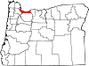
List of Registered Historic Places in Multnomah County, Oregon
Encyclopedia
Portland, Oregon
Portland is a city located in the Pacific Northwest, near the confluence of the Willamette and Columbia rivers in the U.S. state of Oregon. As of the 2010 Census, it had a population of 583,776, making it the 29th most populous city in the United States...
five quadrants.
The National Register of Historic Places
National Register of Historic Places
The National Register of Historic Places is the United States government's official list of districts, sites, buildings, structures, and objects deemed worthy of preservation...
(NRHP) recognizes buildings, structures, objects, sites, and districts of national, state, or local historic significance across the United States
United States
The United States of America is a federal constitutional republic comprising fifty states and a federal district...
. Out of over 80,000 NRHP sites nationwide, Oregon
Oregon
Oregon is a state in the Pacific Northwest region of the United States. It is located on the Pacific coast, with Washington to the north, California to the south, Nevada on the southeast and Idaho to the east. The Columbia and Snake rivers delineate much of Oregon's northern and eastern...
is home to approximately 1,900, and over one-fourth of those are found in Multnomah County
Multnomah County, Oregon
Multnomah County is one of 36 counties in the U.S. state of Oregon. Though smallest in area, it is the most populous as its county seat, Portland, is the state's largest city...
. In turn, the large majority (over 90%) of the county's NRHP sites are situated within Portland.
This list includes only NRHP sites within Multnomah County but outside the municipal boundaries
City limits
The terms city limits and city boundary refer to the defined boundary or border of a city. The area within the city limits is sometimes called the city proper. The terms town limits/boundary and village limits/boundary mean the same as city limits/boundary, but apply to towns and villages...
of Portland. While some sites appear in this list (and corresponding lists for neighboring counties) showing "Portland" as a general locality, they are nevertheless beyond city limits.
Current listings
| Site name | Image | Date listed | Location | City or Town | Summary | |
|---|---|---|---|---|---|---|
| 1 | Emanuel and Christina Anderson House Emanuel and Christina Anderson House The Emanuel and Christina Anderson House, located in Gresham, Oregon, is a house listed on the National Register of Historic Places.... |
 |
1420 SE Roberts Avenue 45.48673°N 122.4171°W |
Gresham Gresham, Oregon - Demographics :As of the census of 2000, there were 90,205 people, 33,327 households, and 22,695 families residing in the city. The population density was 4,071.6 people per square mile . There were 35,309 housing units at an average density of 1,593.8 per square mile... |
||
| 2 | Rae Selling Berry Garden and House Berry Botanic Garden Berry Botanic Garden is a botanical garden in southwest Portland, Oregon, in the United States. In addition to large collections of alpine plants, rhododendrons, primulas, lilies, it is known for its plant-conservation program and its large seed bank that protects rare or endangered plants of the... |
11505 SW Summerville Avenue 45.44238°N 122.6619°W |
Portland Portland, Oregon Portland is a city located in the Pacific Northwest, near the confluence of the Willamette and Columbia rivers in the U.S. state of Oregon. As of the 2010 Census, it had a population of 583,776, making it the 29th most populous city in the United States... |
|||
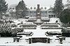
| 3 | Bonneville Dam Historic District Bonneville Dam Bonneville Lock and Dam consists of several run-of-the-river dam structures that together complete a span of the Columbia River between the U.S. states of Oregon and Washington at River Mile 146.1. The dam is located east of Portland, Oregon, in the Columbia River Gorge. The primary functions of... |
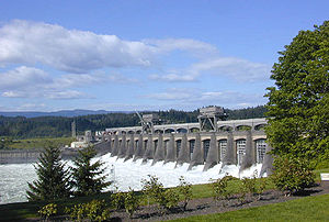 |
Between Interstate 84 and Washington State Route 14 45.64138°N 121.9446°W |
Bonneville Bonneville, Oregon Bonneville is an unincorporated community in Multnomah County, Oregon, United States, on Interstate 84 and the Columbia River. Bonneville is best known as the site of Bonneville Dam... (and North Bonneville, Washington North Bonneville, Washington North Bonneville is a city in Skamania County, Washington, United States. The population was 593 at the 2000 census and 956 at the 2010 census.-Geography:North Bonneville is located at .... ) |
Built Construction In the fields of architecture and civil engineering, construction is a process that consists of the building or assembling of infrastructure. Far from being a single activity, large scale construction is a feat of human multitasking... in the 1930s to harness the Columbia River Columbia River The Columbia River is the largest river in the Pacific Northwest region of North America. The river rises in the Rocky Mountains of British Columbia, Canada, flows northwest and then south into the U.S. state of Washington, then turns west to form most of the border between Washington and the state... for power Electricity Electricity is a general term encompassing a variety of phenomena resulting from the presence and flow of electric charge. These include many easily recognizable phenomena, such as lightning, static electricity, and the flow of electrical current in an electrical wire... generation Electricity generation Electricity generation is the process of generating electric energy from other forms of energy.The fundamental principles of electricity generation were discovered during the 1820s and early 1830s by the British scientist Michael Faraday... , this was the first hydroelectric Hydroelectricity Hydroelectricity is the term referring to electricity generated by hydropower; the production of electrical power through the use of the gravitational force of falling or flowing water. It is the most widely used form of renewable energy... dam Dam A dam is a barrier that impounds water or underground streams. Dams generally serve the primary purpose of retaining water, while other structures such as floodgates or levees are used to manage or prevent water flow into specific land regions. Hydropower and pumped-storage hydroelectricity are... with a hydraulic Hydraulics Hydraulics is a topic in applied science and engineering dealing with the mechanical properties of liquids. Fluid mechanics provides the theoretical foundation for hydraulics, which focuses on the engineering uses of fluid properties. In fluid power, hydraulics is used for the generation, control,... drop sufficient to produce 500,000 kW Watt The watt is a derived unit of power in the International System of Units , named after the Scottish engineer James Watt . The unit, defined as one joule per second, measures the rate of energy conversion.-Definition:... of hydropower Hydropower Hydropower, hydraulic power, hydrokinetic power or water power is power that is derived from the force or energy of falling water, which may be harnessed for useful purposes. Since ancient times, hydropower has been used for irrigation and the operation of various mechanical devices, such as... . The NHL district covers the dam and other elements of the federal Federal government of the United States The federal government of the United States is the national government of the constitutional republic of fifty states that is the United States of America. The federal government comprises three distinct branches of government: a legislative, an executive and a judiciary. These branches and... dam project, including the #1 powerhouse, navigation lock Lock (water transport) A lock is a device for raising and lowering boats between stretches of water of different levels on river and canal waterways. The distinguishing feature of a lock is a fixed chamber in which the water level can be varied; whereas in a caisson lock, a boat lift, or on a canal inclined plane, it is... , fish ladder Fish ladder A fish ladder, also known as a fishway, fish pass or fish steps, is a structure on or around artificial barriers to facilitate diadromous fishes' natural migration. Most fishways enable fish to pass around the barriers by swimming and leaping up a series of relatively low steps into the waters on... , and hatchery. |
|
| 4 | Bybee–Howell House | 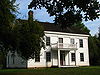 |
13901 NW Howell Park Road 45.64143°N 122.8187°W |
Sauvie Island Sauvie Island Sauvie Island, in the U.S. state of Oregon, originally Wapato Island or Wappatoo Island, is the largest island along the Columbia River, at 26,000 acres , and the largest river island in the United States... |
||
| 5 | Columbia River Highway Historic District |  |
Linear district in Multnomah, Hood River National Register of Historic Places listings in Hood River County, Oregon The following list presents the full set of National Register of Historic Places listings in Hood River County, Oregon, and offers brief descriptive information about each of them. The National Register of Historic Places recognizes buildings, structures, objects, sites, and districts of national,... , and Wasco National Register of Historic Places listings in Wasco County, Oregon The following list includes all of the National Register of Historic Places listings in Wasco County, Oregon, and offers brief descriptive information about each of them. The National Register of Historic Places recognizes buildings, structures, objects, sites, and districts of national, state, or... counties 45°38′36.81"N 121°55′20.27"W (approx.) |
Troutdale Troutdale, Oregon Troutdale is a city in Multnomah County, Oregon, north of Gresham and east of Wood Village. As of the 2010 census, the city population was 15,962.... to The Dalles The Dalles, Oregon The Dalles is the largest city and county seat of Wasco County, Oregon, United States. The name of the city comes from the French word dalle The Dalles is the largest city and county seat of Wasco County, Oregon, United States. The name of the city comes from the French word dalle The Dalles is... |
Constructed between 1913 and 1922, this was the first scenic highway Highway A highway is any public road. In American English, the term is common and almost always designates major roads. In British English, the term designates any road open to the public. Any interconnected set of highways can be variously referred to as a "highway system", a "highway network", or a... in the United States United States The United States of America is a federal constitutional republic comprising fifty states and a federal district... . Design Design Design as a noun informally refers to a plan or convention for the construction of an object or a system while “to design” refers to making this plan... ed specifically to provide visitors Tourism Tourism is travel for recreational, leisure or business purposes. The World Tourism Organization defines tourists as people "traveling to and staying in places outside their usual environment for not more than one consecutive year for leisure, business and other purposes".Tourism has become a... access to the outstanding scenic features of the Columbia River Gorge Columbia River Gorge The Columbia River Gorge is a canyon of the Columbia River in the Pacific Northwest of the United States. Up to deep, the canyon stretches for over as the river winds westward through the Cascade Range forming the boundary between the State of Washington to the north and Oregon to the south... , the highway is also an outstanding example of modern Modernism Modernism, in its broadest definition, is modern thought, character, or practice. More specifically, the term describes the modernist movement, its set of cultural tendencies and array of associated cultural movements, originally arising from wide-scale and far-reaching changes to Western society... highway development Infrastructure Infrastructure is basic physical and organizational structures needed for the operation of a society or enterprise, or the services and facilities necessary for an economy to function... for its pioneering advances in road Road A road is a thoroughfare, route, or way on land between two places, which typically has been paved or otherwise improved to allow travel by some conveyance, including a horse, cart, or motor vehicle. Roads consist of one, or sometimes two, roadways each with one or more lanes and also any... engineering Engineering Engineering is the discipline, art, skill and profession of acquiring and applying scientific, mathematical, economic, social, and practical knowledge, in order to design and build structures, machines, devices, systems, materials and processes that safely realize improvements to the lives of... , and is the single most important contribution to the fields of civil engineering Civil engineering Civil engineering is a professional engineering discipline that deals with the design, construction, and maintenance of the physical and naturally built environment, including works like roads, bridges, canals, dams, and buildings... and landscape architecture Landscape architecture Landscape architecture is the design of outdoor and public spaces to achieve environmental, socio-behavioral, or aesthetic outcomes. It involves the systematic investigation of existing social, ecological, and geological conditions and processes in the landscape, and the design of interventions... by Samuel C. Lancaster Samuel C. Lancaster Samuel Christopher Lancaster was an engineer and landscape architect, most famous for his work on the Columbia River Highway. He was born in 1864 in Magnolia, Mississippi and died from leukemia in 1941.... . |
|
| 6 | Elliott R. Corbett House Elliott R. Corbett House The Elliott R. Corbett House, located near Portland, Oregon, is listed on the National Register of Historic Places.... |
image pending | 01600 SW Greenwood Road 45.43348°N 122.6625°W |
Portland Portland, Oregon Portland is a city located in the Pacific Northwest, near the confluence of the Willamette and Columbia rivers in the U.S. state of Oregon. As of the 2010 Census, it had a population of 583,776, making it the 29th most populous city in the United States... vicinity |
||
| 7 | H.L. Corbett and Gretchen Hoyt House | image pending | 01405 SW Corbett Hill Circle 45.43789°N 122.6642°W |
Portland Portland, Oregon Portland is a city located in the Pacific Northwest, near the confluence of the Willamette and Columbia rivers in the U.S. state of Oregon. As of the 2010 Census, it had a population of 583,776, making it the 29th most populous city in the United States... |
||
| 8 | Maurice Crumpacker House Maurice Crumpacker House Maurice Crumpacker House is the former residence of Maurice E. Crumpacker, a popular Oregon attorney and United States Congressman in the 1920s.... |
 |
12714 SW Iron Mountain Boulevard 45.43305°N 122.659°W |
Portland Portland, Oregon Portland is a city located in the Pacific Northwest, near the confluence of the Willamette and Columbia rivers in the U.S. state of Oregon. As of the 2010 Census, it had a population of 583,776, making it the 29th most populous city in the United States... vicinity |
||
| 9 | Roy and Leola Gangware House Roy and Leola Gangware House The Roy and Leola Gangware House, located in Portland, Oregon, is listed on the National Register of Historic Places.... |
image pending | 4848 SW Humphrey Boulevard 45.50513°N 122.7262°W |
Portland Portland, Oregon Portland is a city located in the Pacific Northwest, near the confluence of the Willamette and Columbia rivers in the U.S. state of Oregon. As of the 2010 Census, it had a population of 583,776, making it the 29th most populous city in the United States... |
||
| 10 | William Gedamke House William Gedamke House The William Gedamke House, located in Gresham, Oregon, is listed on the National Register of Historic Places.... |
 |
1304 E Powell Boulevard 45.49799°N 122.4183°W |
Gresham Gresham, Oregon - Demographics :As of the census of 2000, there were 90,205 people, 33,327 households, and 22,695 families residing in the city. The population density was 4,071.6 people per square mile . There were 35,309 housing units at an average density of 1,593.8 per square mile... |
||
| 11 | Andreas Graf House Andreas Graf House The Andreas Graf House, located in Corbett, Oregon, is listed on the National Register of Historic Places.... |
44222 SE Loudon Road 45.51061°N 122.2076°W |
Corbett Corbett, Oregon Corbett is an unincorporated community on the Columbia River in eastern Multnomah County, Oregon, United States. It is located on the Historic Columbia River Highway between the Sandy River and Crown Point.... |
|||
| 12 | Gresham Carnegie Library Gresham Carnegie Library The Gresham Carnegie Library, located in Gresham, Oregon, is listed on the National Register of Historic Places.... |
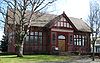 |
410 N Main Street 45.50055°N 122.4303°W |
Gresham Gresham, Oregon - Demographics :As of the census of 2000, there were 90,205 people, 33,327 households, and 22,695 families residing in the city. The population density was 4,071.6 people per square mile . There were 35,309 housing units at an average density of 1,593.8 per square mile... |
||
| 13 | Fred Harlow House Fred Harlow House The Fred Harlow House, located in Troutdale, Oregon, is listed on the National Register of Historic Places.... |
 |
726 E Columbia Street 45.53824°N 122.3822°W |
Troutdale Troutdale, Oregon Troutdale is a city in Multnomah County, Oregon, north of Gresham and east of Wood Village. As of the 2010 census, the city population was 15,962.... |
||
| 14 | Pierre Rossiter and Charlotte Hines House | image pending | 02393 SW Military Road 45.44231°N 122.6544°W |
Portland Portland, Oregon Portland is a city located in the Pacific Northwest, near the confluence of the Willamette and Columbia rivers in the U.S. state of Oregon. As of the 2010 Census, it had a population of 583,776, making it the 29th most populous city in the United States... |
||
| 15 | Dr. Herbert H. Hughes House Dr. Herbert H. Hughes House The Dr. Herbert H. Hughes House, located in Gresham, Oregon, is a house listed on the National Register of Historic Places.... |
 |
1229 W Powell Boulevard 45.49712°N 122.4441°W |
Gresham Gresham, Oregon - Demographics :As of the census of 2000, there were 90,205 people, 33,327 households, and 22,695 families residing in the city. The population density was 4,071.6 people per square mile . There were 35,309 housing units at an average density of 1,593.8 per square mile... |
||
| 16 | Louise Home Hospital and Residence Hall |  |
722 NE 162nd Avenue 45.52831°N 122.4956°W |
Gresham Gresham, Oregon - Demographics :As of the census of 2000, there were 90,205 people, 33,327 households, and 22,695 families residing in the city. The population density was 4,071.6 people per square mile . There were 35,309 housing units at an average density of 1,593.8 per square mile... |
||
| 17 | Donald and Ruth McGraw House Donald and Ruth McGraw House The Donald and Ruth McGraw House, located in Portland, Oregon, is listed on the National Register of Historic Places.... |
image pending | 01845 SW Military Road 45.43847°N 122.66°W |
Portland Portland, Oregon Portland is a city located in the Pacific Northwest, near the confluence of the Willamette and Columbia rivers in the U.S. state of Oregon. As of the 2010 Census, it had a population of 583,776, making it the 29th most populous city in the United States... |
||
| 18 | Multnomah County Poor Farm Multnomah County Poor Farm The Multnomah County Poor Farm is a historic site in Troutdale, Oregon, United States. The former county poor farm is listed on the National Register of Historic Places... |
 |
2126 SW Halsey Street 45.53851°N 122.408°W |
Troutdale Troutdale, Oregon Troutdale is a city in Multnomah County, Oregon, north of Gresham and east of Wood Village. As of the 2010 census, the city population was 15,962.... |
||
| 19 | Multnomah Falls Lodge and Footpath Multnomah Falls -External links:* and , from a USFS website* from the Oregon Tourism Commission* , from a Library of Congress website* * * * *... |
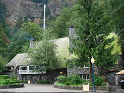 |
Historic Columbia River Highway, northeast of Bridal Veil 45.57645°N 122.1158°W |
Bridal Veil Bridal Veil, Oregon Bridal Veil is a virtual ghost town located in Multnomah County, Oregon, United States. It was established in the 1880s during a logging boom by a logging company as it harvested timber on nearby Larch Mountain to be a company mill town around a sawmill. It had a close relationship with the... vicinity |
||
| 20 | E.J. O'Donnell House | image pending | 5535 SW Hewett Boulevard 45.50397°N 122.735°W |
Portland Portland, Oregon Portland is a city located in the Pacific Northwest, near the confluence of the Willamette and Columbia rivers in the U.S. state of Oregon. As of the 2010 Census, it had a population of 583,776, making it the 29th most populous city in the United States... |
||
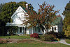
| 21 | Charles and Fae Olson House Charles and Fae Olson House The Charles and Fae Olson House, located in Gresham, Oregon, is listed on the National Register of Historic Places.... |
image pending | 765 SW Walters Road 45°29′29.32"N 122°26′00.70"W |
Gresham Gresham, Oregon - Demographics :As of the census of 2000, there were 90,205 people, 33,327 households, and 22,695 families residing in the city. The population density was 4,071.6 people per square mile . There were 35,309 housing units at an average density of 1,593.8 per square mile... |
This modern Modern architecture Modern architecture is generally characterized by simplification of form and creation of ornament from the structure and theme of the building. It is a term applied to an overarching movement, with its exact definition and scope varying widely... -styled home — designed and hand-built by the novice owner-occupant Owner-occupier An owner-occupier is a person who lives in and owns the same home. It is a type of housing tenure. The home of the owner-occupier may be, for example, a house, apartment, condominium, or a housing cooperative... — embodies the breaks with tradition embraced by the generation returning from World War II World War II World War II, or the Second World War , was a global conflict lasting from 1939 to 1945, involving most of the world's nations—including all of the great powers—eventually forming two opposing military alliances: the Allies and the Axis... . The main outlines of the plan were developed during mail Mail Mail, or post, is a system for transporting letters and other tangible objects: written documents, typically enclosed in envelopes, and also small packages are delivered to destinations around the world. Anything sent through the postal system is called mail or post.In principle, a postal service... correspondence between Mr. and Mrs. Olson while he was serving in the Pacific Pacific Theater of Operations The Pacific Theater of Operations was the World War II area of military activity in the Pacific Ocean and the countries bordering it, a geographic scope that reflected the operational and administrative command structures of the American forces during that period... , and many features are patterned on the books and magazines available to him. |
|
| 22 | John V. G. Posey House John V. G. Posey House The John V. G. Posey House, located in Portland, Oregon, is listed on the National Register of Historic Places.... |
image pending | 02107 SW Greenwood Road 45.43593°N 122.6571°W |
Portland Portland, Oregon Portland is a city located in the Pacific Northwest, near the confluence of the Willamette and Columbia rivers in the U.S. state of Oregon. As of the 2010 Census, it had a population of 583,776, making it the 29th most populous city in the United States... |
||
| 23 | Dr. A.E. and Phila Jane Rockey House | image pending | 10263 SW Riverside Drive 45.45124°N 122.6593°W |
Portland Portland, Oregon Portland is a city located in the Pacific Northwest, near the confluence of the Willamette and Columbia rivers in the U.S. state of Oregon. As of the 2010 Census, it had a population of 583,776, making it the 29th most populous city in the United States... |
||
| 24 | Percy A. Smith House Percy A. Smith House The Percy A. Smith House, located in Portland, Oregon, is listed on the National Register of Historic Places.... |
image pending | 01837 SW Greenwood Road 45.43596°N 122.6603°W |
Portland Portland, Oregon Portland is a city located in the Pacific Northwest, near the confluence of the Willamette and Columbia rivers in the U.S. state of Oregon. As of the 2010 Census, it had a population of 583,776, making it the 29th most populous city in the United States... |
||
| 25 | Springdale School | image pending | 32405 E. Historic Columbia River Highway 45°31′10"N 122°19′46"W |
Corbett Corbett, Oregon Corbett is an unincorporated community on the Columbia River in eastern Multnomah County, Oregon, United States. It is located on the Historic Columbia River Highway between the Sandy River and Crown Point.... vicinity |
||
| 26 | Stanley C.E. Smith House | image pending | 01905 SW Greenwood Road 45.43571°N 122.6585°W |
Portland Portland, Oregon Portland is a city located in the Pacific Northwest, near the confluence of the Willamette and Columbia rivers in the U.S. state of Oregon. As of the 2010 Census, it had a population of 583,776, making it the 29th most populous city in the United States... vicinity |
||
| 27 | Sunken Village Archeological Site (35MU4) Sunken Village Archeological Site Sunken Village Archeological Site is an archaeological site on Sauvie Island in Multnomah County, Oregon, United States.It was declared a National Historic Landmark in 1989.... |
 |
Address restricted | Sauvie Island Sauvie Island Sauvie Island, in the U.S. state of Oregon, originally Wapato Island or Wappatoo Island, is the largest island along the Columbia River, at 26,000 acres , and the largest river island in the United States... |
The archeological Archaeology Archaeology, or archeology , is the study of human society, primarily through the recovery and analysis of the material culture and environmental data that they have left behind, which includes artifacts, architecture, biofacts and cultural landscapes... remains of this Chinookan Chinookan Chinook refers to several native amercain groups of in the Pacific Northwest region of the United States, speaking the Chinookan languages. In the early 19th century, the Chinookan-speaking peoples lived along the lower and middle Columbia River in present-day Oregon and Washington... village Village A village is a clustered human settlement or community, larger than a hamlet with the population ranging from a few hundred to a few thousand , Though often located in rural areas, the term urban village is also applied to certain urban neighbourhoods, such as the West Village in Manhattan, New... are unusually well preserved. This cosmopolitan Cosmopolitanism Cosmopolitanism is the ideology that all human ethnic groups belong to a single community based on a shared morality. This is contrasted with communitarian and particularistic theories, especially the ideas of patriotism and nationalism... people's complex hunter-gatherer Hunter-gatherer A hunter-gatherer or forage society is one in which most or all food is obtained from wild plants and animals, in contrast to agricultural societies which rely mainly on domesticated species. Hunting and gathering was the ancestral subsistence mode of Homo, and all modern humans were... economy Economy An economy consists of the economic system of a country or other area; the labor, capital and land resources; and the manufacturing, trade, distribution, and consumption of goods and services of that area... and extensive trade Trade Trade is the transfer of ownership of goods and services from one person or entity to another. Trade is sometimes loosely called commerce or financial transaction or barter. A network that allows trade is called a market. The original form of trade was barter, the direct exchange of goods and... network allowed them to establish one of the highest population densities Population density Population density is a measurement of population per unit area or unit volume. It is frequently applied to living organisms, and particularly to humans... in aboriginal Indigenous peoples Indigenous peoples are ethnic groups that are defined as indigenous according to one of the various definitions of the term, there is no universally accepted definition but most of which carry connotations of being the "original inhabitants" of a territory.... North America North America North America is a continent wholly within the Northern Hemisphere and almost wholly within the Western Hemisphere. It is also considered a northern subcontinent of the Americas... , yet they left very few physical remains. The site has been subject to erosion Erosion Erosion is when materials are removed from the surface and changed into something else. It only works by hydraulic actions and transport of solids in the natural environment, and leads to the deposition of these materials elsewhere... and looting, problems which have been ameliorated by a protective layer of riprap Riprap Riprap — also known as rip rap, rubble, shot rock or rock armour or "Rip-rap" — is rock or other material used to armor shorelines, streambeds, bridge abutments, pilings and other shoreline structures against scour, water or ice erosion.It is made from a variety of rock types, commonly granite or... . |
|
| 28 | Troutdale Methodist Episcopal Church Troutdale Methodist Episcopal Church Troutdale Methodist Episcopal Church is a historic church at 302 SE Harlow Street in Troutdale, Oregon.It was built in 1895 and added to the National Register of Historic Places in 1993.... |
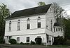 |
302 SE Harlow Street 45.53946°N 122.3863°W |
Troutdale Troutdale, Oregon Troutdale is a city in Multnomah County, Oregon, north of Gresham and east of Wood Village. As of the 2010 census, the city population was 15,962.... |
||
| 29 | View Point Inn View Point Inn The View Point Inn, located in Corbett, Oregon, is listed on the National Register of Historic Places. In July 2011, the building was gutted by a fire and faced financial difficulties.-External links:*... |
 |
40301 NE Larch Mountain Road 45.53272°N 122.2488°W |
Corbett Corbett, Oregon Corbett is an unincorporated community on the Columbia River in eastern Multnomah County, Oregon, United States. It is located on the Historic Columbia River Highway between the Sandy River and Crown Point.... |
Set on a high promontory with a sweeping view of the Columbia River Gorge Columbia River Gorge The Columbia River Gorge is a canyon of the Columbia River in the Pacific Northwest of the United States. Up to deep, the canyon stretches for over as the river winds westward through the Cascade Range forming the boundary between the State of Washington to the north and Oregon to the south... , this is the only remaining example of several fashionable resort Resort A resort is a place used for relaxation or recreation, attracting visitors for holidays or vacations. Resorts are places, towns or sometimes commercial establishment operated by a single company.... inns that developed in conjunction with the Columbia River Highway in the 1910s and 1920s. In addition to illustrating the rise of automobile Automobile An automobile, autocar, motor car or car is a wheeled motor vehicle used for transporting passengers, which also carries its own engine or motor... touring in the United States, it is also the only inn produced by prominent Portland Portland, Oregon Portland is a city located in the Pacific Northwest, near the confluence of the Willamette and Columbia rivers in the U.S. state of Oregon. As of the 2010 Census, it had a population of 583,776, making it the 29th most populous city in the United States... architect Architect An architect is a person trained in the planning, design and oversight of the construction of buildings. To practice architecture means to offer or render services in connection with the design and construction of a building, or group of buildings and the space within the site surrounding the... Carl L. Linde. |
|
| 30 | Vista House Crown Point (Oregon) Crown Point is the name of a promontory on the Columbia River Gorge and an associated state park in the U.S. state of Oregon. It is located in eastern Multnomah County, approximately 15 miles east of Portland. Crown Point is one of the scenic lookouts along the Historic Columbia River Highway,... |
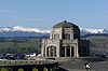 |
Historic Columbia River Highway 45.53989°N 122.2451°W |
Crown Point Crown Point (Oregon) Crown Point is the name of a promontory on the Columbia River Gorge and an associated state park in the U.S. state of Oregon. It is located in eastern Multnomah County, approximately 15 miles east of Portland. Crown Point is one of the scenic lookouts along the Historic Columbia River Highway,... |
||
| 31 | Whidden–Kerr House and Garden | image pending | 11648 SW Military Lane 45.44141°N 122.6533°W |
Portland Portland, Oregon Portland is a city located in the Pacific Northwest, near the confluence of the Willamette and Columbia rivers in the U.S. state of Oregon. As of the 2010 Census, it had a population of 583,776, making it the 29th most populous city in the United States... |
||
| 32 | Theodore B. Wilcox Country Estate Theodore B. Wilcox Country Estate The Theodore B. Wilcox Country Estate, located in Portland, Oregon, is listed on the National Register of Historic Places.... |
 |
3707 SW 52nd Place 45.49583°N 122.7295°W |
Portland Portland, Oregon Portland is a city located in the Pacific Northwest, near the confluence of the Willamette and Columbia rivers in the U.S. state of Oregon. As of the 2010 Census, it had a population of 583,776, making it the 29th most populous city in the United States... |
||
| 33 | Jacob Zimmerman House Jacob Zimmerman House Jacob Zimmerman House was the home of Jacob and Lena Zimmerman, European American settlers who came west over the Oregon Trail in 1851 to what became Multnomah County in the U.S. state of Oregon. Built in 1874, the house was part of a dairy farm. Members of the Zimmerman family lived on the farm... |
 |
17111 NE Sandy Boulevard 45.54802°N 122.488°W |
Gresham Gresham, Oregon - Demographics :As of the census of 2000, there were 90,205 people, 33,327 households, and 22,695 families residing in the city. The population density was 4,071.6 people per square mile . There were 35,309 housing units at an average density of 1,593.8 per square mile... |
Former listings
| Landmark name | Image | Date removed | Location | City or Town | Summary | |
|---|---|---|---|---|---|---|
| 1 | Lewis H. Mills House Lewis H. Mills House (1929) The Lewis H. Mills House, once located in Portland, Oregon, was listed on the National Register of Historic Places.... |
image pending | 1350 SW Military Road 45.43992°N 122.6663°W |
Portland Portland, Oregon Portland is a city located in the Pacific Northwest, near the confluence of the Willamette and Columbia rivers in the U.S. state of Oregon. As of the 2010 Census, it had a population of 583,776, making it the 29th most populous city in the United States... |
Listed February 21, 1997 |
Portland
Over 500 NRHP listings lie within the legal boundaries of Portland. Although all of these sites lie within Multnomah County, their sheer number makes it prohibitive to include them all in the same table. To find detailed listings for each of Portland's five quadrants, click on a link below or on the map at the right.National Register of Historic Places listings in North Portland, Oregon
The following list attempts to comprehensively present the full set of National Register of Historic Places listings in North Portland, Oregon, and offers brief descriptive information about each of them...
• Northeast
National Register of Historic Places listings in Northeast Portland, Oregon
The following list attempts to comprehensively present the full set of National Register of Historic Places listings in Northeast Portland, Oregon, and offers brief descriptive information about each of them...
• Northwest
National Register of Historic Places listings in Northwest Portland, Oregon
The following list attempts to comprehensively present the full set of National Register of Historic Places listings in Northwest Portland, Oregon, and offers brief descriptive information about each of them...
• Southeast
National Register of Historic Places listings in Southeast Portland, Oregon
The following list attempts to comprehensively present the full set of National Register of Historic Places listings in Southeast Portland, Oregon, and offers brief descriptive information about each of them...
• Southwest
National Register of Historic Places listings in Southwest Portland, Oregon
The following list attempts to comprehensively present the full set of National Register of Historic Places listings in Southwest Portland, Oregon, and offers brief descriptive information about each of them...
See also
- National Register of Historic Places listings in Oregon
- Listings in adjacent counties: ClackamasNational Register of Historic Places listings in Clackamas County, OregonThe following list includes all of the National Register of Historic Places listings in Clackamas County, Oregon, and offers brief descriptive information about each of them. The National Register of Historic Places recognizes buildings, structures, objects, sites, and districts of national,...
, Clark, ColumbiaNational Register of Historic Places listings in Columbia County, OregonThe following list presents the full set of National Register of Historic Places listings in Columbia County, Oregon, and offers brief descriptive information about each of them. The National Register of Historic Places recognizes buildings, structures, objects, sites, and districts of national,...
, Hood RiverNational Register of Historic Places listings in Hood River County, OregonThe following list presents the full set of National Register of Historic Places listings in Hood River County, Oregon, and offers brief descriptive information about each of them. The National Register of Historic Places recognizes buildings, structures, objects, sites, and districts of national,...
, Skamania, WashingtonNational Register of Historic Places listings in Washington County, OregonThe following list presents the full set of National Register of Historic Places listings in Washington County, Oregon, and offers brief descriptive information about each of them. The National Register of Historic Places recognizes buildings, structures, objects, sites, and districts of national,... - List of National Historic Landmarks in Oregon
- Historic preservationHistoric preservationHistoric preservation is an endeavor that seeks to preserve, conserve and protect buildings, objects, landscapes or other artifacts of historical significance...
- History of OregonHistory of OregonThe history of Oregon, a U.S. state, may be considered in five eras: geologic history, inhabitation by native peoples, early exploration by Europeans , settlement by pioneers, and modern development....
- Lists of Oregon-related topics