
List of Registered Historic Places in Louisiana
Encyclopedia
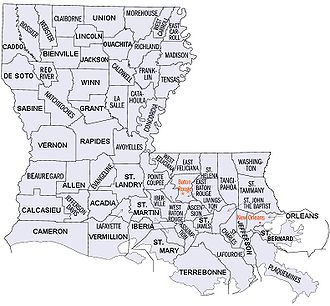
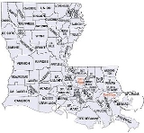
This is a list of properties and districts in Louisiana
Louisiana
Louisiana is a state located in the southern region of the United States of America. Its capital is Baton Rouge and largest city is New Orleans. Louisiana is the only state in the U.S. with political subdivisions termed parishes, which are local governments equivalent to counties...
that are listed on the National Register of Historic Places
National Register of Historic Places
The National Register of Historic Places is the United States government's official list of districts, sites, buildings, structures, and objects deemed worthy of preservation...
. There are listings in each of Louisiana's 64 parishes.
The locations of National Register properties and districts (at least for all showing latitude and longitude coordinates below), may be seen in a Google map by clicking on "Map of all coordinates".
Current listings by parish
| Parish | # of Sites | |
|---|---|---|
| 1 | Acadia | 7 |
| 2 | Allen | 4 |
| 3 | Ascension National Register of Historic Places listings in Ascension Parish, Louisiana This is a list of the National Register of Historic Places listings in Ascension Parish, Louisiana.This is intended to be a complete list of the properties and districts on the National Register of Historic Places in Ascension Parish, Louisiana, United States... |
19 |
| 4 | Assumption | 9 |
| 5 | Avoyelles National Register of Historic Places listings in Avoyelles Parish, Louisiana This is a list of the National Register of Historic Places listings in Avoyelles Parish, Louisiana.This is intended to be a complete list of the properties and districts on the National Register of Historic Places in Avoyelles Parish, Louisiana, United States... |
31 |
| 6 | Beauregard | 13 |
| 7 | Bienville | 12 |
| 8 | Bossier | 6 |
| 9 | Caddo National Register of Historic Places listings in Caddo Parish, Louisiana This is a list of the National Register of Historic Places listings in Caddo Parish, Louisiana.This is intended to be a complete list of the properties and districts on the National Register of Historic Places in Caddo Parish, Louisiana, United States... |
64 |
| 10 | Calcasieu National Register of Historic Places listings in Calcasieu Parish, Louisiana This is a list of the National Register of Historic Places listings in Calcasieu Parish, Louisiana.This is intended to be a complete list of the properties and districts on the National Register of Historic Places in Calcasieu Parish, Louisiana, United States... |
18 |
| 11 | Caldwell | 9 |
| 12 | Cameron | 2 |
| 13 | Catahoula | 13 |
| 14 | Claiborne | 10 |
| 15 | Concordia | 13 |
| 16 | De Soto National Register of Historic Places listings in De Soto Parish, Louisiana This is a list of the National Register of Historic Places listings in DeSoto Parish, Louisiana.This is intended to be a complete list of the properties and districts on the National Register of Historic Places in DeSoto Parish, Louisiana, United States... |
31 |
| 17 | East Baton Rouge National Register of Historic Places listings in East Baton Rouge Parish, Louisiana This is a list of the National Register of Historic Places listings in East Baton Rouge Parish, Louisiana.This is intended to be a complete list of the properties and districts on the National Register of Historic Places in East Baton Rouge Parish, Louisiana, United States... |
83 |
| 18 | East Carroll | 8 |
| 19 | East Feliciana National Register of Historic Places listings in East Feliciana Parish, Louisiana This is a list of the National Register of Historic Places listings in East Feliciana Parish, Louisiana.This is intended to be a complete list of the properties and districts on the National Register of Historic Places in East Feliciana Parish, Louisiana, United States... |
32 |
| 20 | Evangeline | 6 |
| 21 | Franklin | 6 |
| 22 | Grant | 4 |
| 23 | Iberia National Register of Historic Places listings in Iberia Parish, Louisiana This is a list of the National Register of Historic Places listings in Iberia Parish, Louisiana.This is intended to be a complete list of the properties and districts on the National Register of Historic Places in Iberia Parish, Louisiana, United States... |
31 |
| 24 | Iberville National Register of Historic Places listings in Iberville Parish, Louisiana This is a list of the National Register of Historic Places listings in Iberville Parish, Louisiana.This is intended to be a complete list of the properties and districts on the National Register of Historic Places in Iberville Parish, Louisiana, United States... |
22 |
| 25 | Jackson | 5 |
| 26 | Jefferson National Register of Historic Places listings in Jefferson Parish, Louisiana This is a list of the National Register of Historic Places listings in Jefferson Parish, Louisiana.This is intended to be a complete list of the properties and districts on the National Register of Historic Places in Jefferson Parish, Louisiana, United States... |
19 |
| 27 | Jefferson Davis National Register of Historic Places listings in Jefferson Davis Parish, Louisiana This is a list of the National Register of Historic Places listings in Jefferson Davis Parish, Louisiana.This is intended to be a complete list of the properties on the National Register of Historic Places in Jefferson Davis Parish, Louisiana, United States... |
19 |
| 28 | La Salle | 3 |
| 29 | Lafayette National Register of Historic Places listings in Lafayette Parish, Louisiana This is a list of the National Register of Historic Places listings in Lafayette Parish, Louisiana.This is intended to be a complete list of the properties and districts on the National Register of Historic Places in Lafayette Parish, Louisiana, United States... |
34 |
| 30 | Lafourche National Register of Historic Places listings in Lafourche Parish, Louisiana This is a list of the National Register of Historic Places listings in Lafourche Parish, Louisiana.This is intended to be a complete list of the properties and districts on the National Register of Historic Places in Lafourche Parish, Louisiana, United States... |
35 |
| 31 | Lincoln National Register of Historic Places listings in Lincoln Parish, Louisiana This is a list of the National Register of Historic Places listings in Lincoln Parish, Louisiana.This is intended to be a complete list of the properties on the National Register of Historic Places in Lincoln Parish, Louisiana, United States... |
28 |
| 32 | Livingston | 12 |
| 33 | Madison | 13 |
| 34 | Morehouse | 9 |
| 35 | Natchitoches National Register of Historic Places listings in Natchitoches Parish, Louisiana This is a list of the National Register of Historic Places listings in Natchitoches Parish, Louisiana.This is intended to be a complete list of the properties and districts on the National Register of Historic Places in Natchitoches Parish, Louisiana, United States... |
32 |
| 36 | Orleans National Register of Historic Places listings in Orleans Parish, Louisiana This is a list of the National Register of Historic Places listings in Orleans Parish, Louisiana.This is intended to be a complete list of the properties and districts on the National Register of Historic Places in Orleans Parish, Louisiana, United States... |
143 |
| 37 | Ouachita National Register of Historic Places listings in Ouachita Parish, Louisiana This is a list of the National Register of Historic Places listings in Ouachita Parish, Louisiana.This is intended to be a complete list of the properties and districts on the National Register of Historic Places in Ouachita Parish, Louisiana, United States... |
31 |
| 38 | Plaquemines | 8 |
| 39 | Pointe Coupee National Register of Historic Places listings in Pointe Coupee Parish, Louisiana This is a list of the National Register of Historic Places listings in Pointe Coupee Parish, Louisiana.This is intended to be a complete list of the properties on the National Register of Historic Places in Pointe Coupee Parish, Louisiana, United States... |
32 |
| 40 | Rapides National Register of Historic Places listings in Rapides Parish, Louisiana This is a list of the National Register of Historic Places listings in Rapides Parish, Louisiana.This is intended to be a complete list of the properties and districts on the National Register of Historic Places in Rapides Parish, Louisiana, United States... |
70 |
| 41 | Red River | 3 |
| 42 | Richland | 10 |
| 43 | Sabine | 7 |
| 44 | St. Bernard | 8 |
| 45 | St. Charles | 6 |
| 46 | St. Helena | 2 |
| 47 | St. James National Register of Historic Places listings in St. James Parish, Louisiana This is a list of the National Register of Historic Places listings in St. James Parish, Louisiana.This is intended to be a complete list of the properties and districts on the National Register of Historic Places in St. James Parish, Louisiana, United States... |
21 |
| 48 | St. John the Baptist National Register of Historic Places listings in St. John the Baptist Parish, Louisiana This is a list of the National Register of Historic Places listings in St. John the Baptist Parish, Louisiana.This is intended to be a complete list of the properties and districts on the National Register of Historic Places in St. John the Baptist Parish, Louisiana, United States... |
16 |
| 49 | St. Landry National Register of Historic Places listings in St. Landry Parish, Louisiana This is a list of the National Register of Historic Places listings in St. Landry Parish, Louisiana.This is intended to be a complete list of the properties and districts on the National Register of Historic Places in St. Landry Parish, Louisiana, United States... |
36 |
| 50 | St. Martin National Register of Historic Places listings in St. Martin Parish, Louisiana This is a list of the National Register of Historic Places listings in St. Martin Parish, Louisiana.This is intended to be a complete list of the properties and districts on the National Register of Historic Places in St. Martin Parish, Louisiana, United States... |
25 |
| 51 | St. Mary National Register of Historic Places listings in St. Mary Parish, Louisiana This is a list of the National Register of Historic Places listings in St. Mary Parish, Louisiana.This is intended to be a complete list of the properties and districts on the National Register of Historic Places in St. Mary Parish, Louisiana, United States... |
27 |
| 52 | St. Tammany National Register of Historic Places listings in St. Tammany Parish, Louisiana This is a list of the National Register of Historic Places listings in St. Tammany Parish, Louisiana.This is intended to be a complete list of the properties and districts on the National Register of Historic Places in St. Tammany Parish, Louisiana, United States... |
39 |
| 53 | Tangipahoa National Register of Historic Places listings in Tangipahoa Parish, Louisiana This is a list of the National Register of Historic Places listings in Tangipahoa Parish, Louisiana.This is intended to be a complete list of the properties and districts on the National Register of Historic Places in Tangipahoa Parish, Louisiana, United States... |
32 |
| 54 | Tensas | 10 |
| 55 | Terrebonne National Register of Historic Places listings in Terrebonne Parish, Louisiana This is a list of the National Register of Historic Places listings in Terrebonne Parish, Louisiana.This is intended to be a complete list of the properties and districts on the National Register of Historic Places in Terrebonne Parish, Louisiana, United States... |
17 |
| 56 | Union | 11 |
| 57 | Vermilion National Register of Historic Places listings in Vermilion Parish, Louisiana This is a list of the National Register of Historic Places listings in Vermilion Parish, Louisiana.This is intended to be a complete list of the properties and districts on the National Register of Historic Places in Vermilion Parish, Louisiana, United States... |
18 |
| 58 | Vernon National Register of Historic Places listings in Vernon Parish, Louisiana This is a list of the National Register of Historic Places listings in Vernon Parish, Louisiana.This is intended to be a complete list of the properties and districts on the National Register of Historic Places in Vernon Parish, Louisiana, United States... |
16 |
| 59 | Washington National Register of Historic Places listings in Washington Parish, Louisiana This is a list of the National Register of Historic Places listings in Washington Parish, Louisiana.This is intended to be a complete list of the properties on the National Register of Historic Places in Washington Parish, Louisiana, United States... |
15 |
| 60 | Webster National Register of Historic Places listings in Webster Parish, Louisiana This is a list of the National Register of Historic Places listings in Webster Parish, Louisiana.This is intended to be a complete list of the properties and districts on the National Register of Historic Places in Webster Parish, Louisiana, United States... |
19 |
| 61 | West Baton Rouge | 13 |
| 62 | West Carroll | 2 |
| 63 | West Feliciana National Register of Historic Places listings in West Feliciana Parish, Louisiana This is a list of the National Register of Historic Places listings in West Feliciana Parish, Louisiana.This is intended to be a complete list of the properties and districts on the National Register of Historic Places in West Feliciana Parish, Louisiana, United States... |
30 |
| 64 | Winn | 7 |
| (duplicates) | (0) | |
| Total: | 1,336 | |
Acadia ParishAcadia Parish, LouisianaAcadia Parish is a parish located in the U.S. state of Louisiana. The parish seat is Crowley. According to the 2010 census, the population of Acadia Parish is 61,773. The parish was founded from parts of St...
| Landmark name | Image | Date listed | Location width = 8% |City or Town |
Summary | ||
|---|---|---|---|---|---|---|
| 1 | Joseph D. Bernard House | 1023 The Boulevard 30°14′51"N 92°16′12"W |
Rayne Rayne, Louisiana Rayne is a city in Acadia Parish, Louisiana, United States. The population was 8,552 at the 2000 census. It is nicknamed the "Frog Capital of the World", as well as the "Louisiana City of Murals".Rayne is part of the Crowley Micropolitan Statistical Area.... |
|||
| 2 | Colorado Southern Railroad Depot | N. Ave. G and E. Front St. 30°12′22"N 92°23′10"W |
Crowley Crowley, Louisiana Crowley is a city in and the parish seat of Acadia Parish, Louisiana, United States. The population was 14,225 at the 2000 census. The city is noted for its annual International Rice Festival. Crowley has the nickname of "Rice Capital of America", because at one time it was a major center for... |
|||
| 3 | Crowley Historic District |  |
U.S. Route 90 U.S. Route 90 U.S. Route 90 is an east–west United States highway. Despite the "0" in its route number, U.S. 90 never was a full coast-to-coast route; it has always ended at Van Horn, Texas. A short-lived northward extension to U.S... and Louisiana Highway 13 Louisiana Highway 13 Louisiana Highway 13 is a state highway in Vermilion Parish, Acadia Parish, and Evangeline Parish. It spans .-Route description:... 30°12′44"N 92°22′8"W |
Crowley Crowley, Louisiana Crowley is a city in and the parish seat of Acadia Parish, Louisiana, United States. The population was 14,225 at the 2000 census. The city is noted for its annual International Rice Festival. Crowley has the nickname of "Rice Capital of America", because at one time it was a major center for... |
||
| 4 | Ellis Hoffpauir House | 210 LeBlanc St. 30°10′55"N 92°27′51"W |
Estherwood Estherwood, Louisiana Estherwood is a village in Acadia Parish, Louisiana, United States. The population was 807 at the 2000 census. It is part of the Crowley Micropolitan Statistical Area.-History:... |
|||
| 5 | Istre Cemetery Grave Houses | Swift Rd. 30°6′56"N 92°33′53"W |
Morse Morse, Louisiana Morse is a village in Acadia Parish, Louisiana, United States. The population was 759 at the 2000 census. It is part of the Crowley Micropolitan Statistical Area.Incorporated as a village in 1906, it was settled by farmers from Illinois and Iowa... |
|||
| 6 | Le Vieux Presbytere | 205 Rue Iry Lejeune 30°24′22"N 92°12′56"W |
Church Point Church Point, Louisiana Church Point is a town in Acadia Parish, Louisiana, United States. The population was 4,756 at the 2000 census. It is part of the Crowley Micropolitan Statistical Area.-History:... |
|||
| 7 | Lewis & Taylor Lumberyard Office | 403 E. Louisiana Ave. 30°14′9"N 92°15′55"W |
Rayne Rayne, Louisiana Rayne is a city in Acadia Parish, Louisiana, United States. The population was 8,552 at the 2000 census. It is nicknamed the "Frog Capital of the World", as well as the "Louisiana City of Murals".Rayne is part of the Crowley Micropolitan Statistical Area.... |
Allen ParishAllen Parish, LouisianaAllen Parish is a parish located in the U.S. state of Louisiana. The parish seat is Oberlin. As of the 2000 census, the population was 25,440. Allen Parish is in southwestern Louisiana, southwest of Alexandria....
| Landmark name | Image | Date listed | Location | City or Town | Summary | |
|---|---|---|---|---|---|---|
| 1 | Allen Parish Courthouse | 5th St. 30°37′13"N 92°46′4"W |
Oberlin Oberlin, Louisiana Oberlin is a town in and the parish seat of Allen Parish, Louisiana, United States. The population was 1,853 at the 2000 census. The town is named after Johan Friedrich Oberlin.-Geography:Oberlin is located at .... |
|||
| 2 | Elizabeth Hospital Building | Mimosa Dr. 30°51′53"N 92°47′43"W |
Elizabeth Elizabeth, Louisiana Elizabeth is a town in Allen Parish, Louisiana, United States. The population was 574 at the 2000 census.-Geography:Elizabeth is located at .... |
|||
| 3 | Genius Brothers Building | Junction of 8th St. and 4th Ave. 30°29′14"N 92°51′1"W |
Kinder Kinder, Louisiana Kinder is a town in Allen Parish, Louisiana, United States. The population was 2,148 at the 2000 census.The Lieutenant Douglas B. Fournet Memorial Park , an American Legion enterprise, was dedicated on June 11, 1988, in Kinder to remember those who died in military service to the nation.Kinder was... |
|||
| 4 | St. Paul Baptist Church-Morehead School | 772 Hickory Flats Rd. 30°33′3"N 92°49′27"W |
Kinder Kinder, Louisiana Kinder is a town in Allen Parish, Louisiana, United States. The population was 2,148 at the 2000 census.The Lieutenant Douglas B. Fournet Memorial Park , an American Legion enterprise, was dedicated on June 11, 1988, in Kinder to remember those who died in military service to the nation.Kinder was... |
Ascension ParishAscension Parish, LouisianaAscension Parish is a parish located in the U.S. state of Louisiana. It is the fastest growing parish in the state. Its population is 107,215 which is 39.9% greater than the 2000 census...
Assumption ParishAssumption Parish, LouisianaAssumption Parish is a parish located in the U.S. state of Louisiana, and was formed in 1807 as an original parish of the Louisiana Territory. Its parish seat is Napoleonville. In 2000, its population was 23,388. Assumption is one of the 22 Acadiana parishes. Its major product is sugarcane...
| Landmark name | Image | Date listed | Location | City or Town | Summary | |
|---|---|---|---|---|---|---|
| 1 | Assumption Parish Courthouse and Jail | 4809 Louisiana Highway 1 Louisiana Highway 1 Louisiana Highway 1 is a state highway in Louisiana. At 436.20 miles , it is the longest numbered highway of any class in Louisiana. It runs diagonally across the state, connecting the oil and gas fields near the island of Grand Isle with the northwest corner of the state, north of Shreveport.The... 29°56′28"N 91°1′28"W |
Napoleonville Napoleonville, Louisiana Napoleonville is a village in and the parish seat of Assumption Parish, in the U.S. state of Louisiana. The population was 686 at the 2000 census. It is part of the Pierre Part Micropolitan Statistical Area.-History:... |
|||
| 2 | Belle Alliance Belle Alliance Plantation Belle Alliance is an Italianate and Greek Revival plantation house in Assumption Parish, Louisiana. An unincorporated community named Belle Alliance is named after the Plantation... |
Louisiana Highway 308, approximately 4 miles north of its junction with Louisiana Highway 70 Louisiana Highway 70 Louisiana Highway 70 is a state highway in Louisiana that serves St. Mary, St. Martin, Assumption, and Ascension Parishes. It is primarily a two-lane highway that spans .-Route description:... 30°3′20"N 91°1′59"W |
Donaldsonville Donaldsonville, Louisiana Donaldsonville is a city in and the parish seat of Ascension Parish, Louisiana, United States, along the west bank of the Mississippi River. The population was 7,605 at the 2000 census. It is part of the Baton Rouge Metropolitan Statistical Area.-History:Acadians began to settle in the area in... |
|||
| 3 | Christ Episcopal Church and Cemetery | Louisiana Highway 1 Louisiana Highway 1 Louisiana Highway 1 is a state highway in Louisiana. At 436.20 miles , it is the longest numbered highway of any class in Louisiana. It runs diagonally across the state, connecting the oil and gas fields near the island of Grand Isle with the northwest corner of the state, north of Shreveport.The... between Courthouse St. and Louisiana Highway 1008 29°56′30"N 91°1′33"W |
Napoleonville Napoleonville, Louisiana Napoleonville is a village in and the parish seat of Assumption Parish, in the U.S. state of Louisiana. The population was 686 at the 2000 census. It is part of the Pierre Part Micropolitan Statistical Area.-History:... |
|||
| 4 | Church of the Assumption of the Blessed Virgin Mary | Louisiana Highway 308 29°59′24"N 91°1′24"W |
Plattenville Plattenville, Louisiana Plattenville is an unincorporated community in Assumption Parish, Louisiana, United States. The population was 1,965 at the 2000 census.-References:... |
|||
| 5 | LaBarre House | 4371 Louisiana Highway 1 Louisiana Highway 1 Louisiana Highway 1 is a state highway in Louisiana. At 436.20 miles , it is the longest numbered highway of any class in Louisiana. It runs diagonally across the state, connecting the oil and gas fields near the island of Grand Isle with the northwest corner of the state, north of Shreveport.The... |
Napoleonville Napoleonville, Louisiana Napoleonville is a village in and the parish seat of Assumption Parish, in the U.S. state of Louisiana. The population was 686 at the 2000 census. It is part of the Pierre Part Micropolitan Statistical Area.-History:... |
|||
| 6 | Madewood Madewood Plantation House Madewood Plantation House, also known as Madewood, is a National Historic Landmark in Napoleonville, Louisiana, USA. Built for the Pugh family in 1845 and designed by architect Henry Howard, the house was originally part of a sugar plantation.... |
East of Napoleonville on Louisiana Highway 308 29°55′33"N 90°59′39"W |
Napoleonville Napoleonville, Louisiana Napoleonville is a village in and the parish seat of Assumption Parish, in the U.S. state of Louisiana. The population was 686 at the 2000 census. It is part of the Pierre Part Micropolitan Statistical Area.-History:... |
|||
| 7 | St. Anne Catholic Church | St. Joseph St. |
Napoleonville Napoleonville, Louisiana Napoleonville is a village in and the parish seat of Assumption Parish, in the U.S. state of Louisiana. The population was 686 at the 2000 census. It is part of the Pierre Part Micropolitan Statistical Area.-History:... |
|||
| 8 | St. Elizabeth Catholic Church | Louisiana Highway 402 29°59′41"N 91°3′32"W |
Paincourtville Paincourtville, Louisiana Paincourtville is a census-designated place in Assumption Parish, Louisiana, United States. The population was 884 at the 2000 census. It is part of the Pierre Part Micropolitan Statistical Area.... |
|||
| 9 | St. Philomene Catholic Church and Rectory | Louisiana Highway 1 Louisiana Highway 1 Louisiana Highway 1 is a state highway in Louisiana. At 436.20 miles , it is the longest numbered highway of any class in Louisiana. It runs diagonally across the state, connecting the oil and gas fields near the island of Grand Isle with the northwest corner of the state, north of Shreveport.The... 29°50′21"N 90°57′16"W |
Labadieville Labadieville, Louisiana Labadieville is a census-designated place in Assumption Parish, Louisiana, United States. The population was 1,811 at the 2000 census. It is part of the Pierre Part Micropolitan Statistical Area.-History:... |
Avoyelles ParishAvoyelles Parish, LouisianaAvoyelles is a parish located in the U.S. state of Louisiana. The parish seat is Marksville. In 2000, its population was 41,481. The parish is named for the Avoyel Indian tribe.-History:...
Beauregard ParishBeauregard Parish, LouisianaBeauregard Parish [p] is a parish located in the U.S. state of Louisiana. Beauregard Parish was formed on 1 January 1913. The parish seat is DeRidder. As of 2000, the population was 32,986. Beauregard Parish is part of the DeRidder Micropolitan Statistical Area as well as the Fort Polk...
| Landmark name | Image | Date listed | Location | City or Town | Summary | |
|---|---|---|---|---|---|---|
| 1 | Beauregard Parish Courthouse Beauregard Parish Courthouse The Beauregard Parish Courthouse was the answer to a need for a new Parish. DeRidder beat out Singer for the location of the parish seat. The courthouse was built at the same time as the Beauregard Parish Jail, by the same people, and completed around the same time in 1915, as directed by the... |
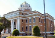 |
1st St. 30°50′46"N 93°17′13"W |
DeRidder | ||
| 2 | Beauregard Parish Jail Beauregard Parish Jail Beauregard Parish Jail is a former jailhouse in DeRidder, Louisiana built in 1914 in the Gothic Revival architecture style. It is often referred to as the Gothic jail or the Hanging jail. It was listed on the National Register of Historic Places on December 17, 1981. The jail is owned by the... |
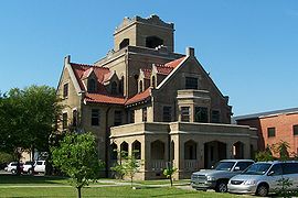 |
Courthouse Sq. 30°50′46"N 93°17′20"W |
DeRidder | ||
| 3 | Beauregard Parish Training School Beauregard Parish Training School The Beauregard Parish Training School in DeRidder, Louisiana, was a school for education of black students and for training of black teachers... |
Junction of Martin Luther King Dr. and Alexander St. 30°50′33"N 93°16′20"W |
DeRidder | |||
| 4 | Burks House Burks House (Merryville, Louisiana) Burks House, is a log cabin with a mud daub chimney built in 1883. The house is typical of those built in the 19th century when the area was officially open to homesteading.... |
Junction of Railroad Ave. and Main St. 30°45′15"N 93°32′26"W |
Merryville Merryville, Louisiana Merryville is a town in Beauregard Parish, Louisiana, United States. The population was 1,126 at the 2000 census. It is part of the DeRidder Micropolitan Statistical Area.-Geography:Merryville is located at .... |
|||
| 5 | DeRidder Commercial Historic District DeRidder Commercial Historic District The DeRidder Commercial Historic District covers an area from the Railroad tracks at Washington street and includes Second, Stewart, and Port street. In 1983 the buildings were added to the National Register of Historic Places.-History:... |
Roughly bounded by the railroad line and 2nd, Stewart, and Port Sts. 30°50′49"N 93°17′9"W |
DeRidder | |||
| 6 | DeRidder USO Building DeRidder USO Building The DeRidder USO was built for the same reasons as all other United Service Organizations; to provide a relaxing atmosphere to members of the armed forces... |
Junction of Pine and 7th Sts. 30°50′26"N 93°17′18"W |
DeRidder | |||
| 7 | Dry Creek High School Building | Louisiana Highway 113 Louisiana Highway 113 Louisiana Highway 113 is a state highway in Louisiana. It spans and runs from South to north. LA 113 is a mostly rural two lane highway with a maximum speed limit of per hour and a minimum of as slow as per hour in some sharp curves. The southern terminus is at an intersection with U.S. 190 in... 30°40′10"N 93°2′42"W |
Dry Creek Dry Creek, Louisiana Dry Creek is a rural unincorporated community in the east-central portion of Beauregard Parish, Louisiana, United States. It lies 20 miles southeast of Deridder on the corner of LA 113 and LA 394... |
|||
| 8 | First Street School | 500 W. 1st St. 30°50′52"N 93°17′23"W |
DeRidder | |||
| 9 | First United Methodist Church | Junction of Pine and N. Port Sts. 30°50′54"N 93°17′21"W |
DeRidder | |||
| 10 | Hudson River Lumber Company General Manager's House | 411 S. Washington Ave. 30°50′40"N 93°17′12"W |
DeRidder | |||
| 11 | Shady Grove School and Community Building | 2400 Louisiana Highway 26 Louisiana Highway 26 Louisiana Highway 26 is a state highway that serves Beauregard Parish, Allen Parish, and Jefferson Davis Parish. It spans , running in a northwest/southeast direction-Route description:... 30°48′21"N 93°10′32"W |
DeRidder | |||
| 12 | Sills House | 211 W. 4th St. 30°50′45"N 93°17′19"W |
DeRidder | |||
| 13 | Toy House | 205 W. 4th St. 30°50′45"N 93°17′17"W |
DeRidder |
Bienville ParishBienville Parish, LouisianaBienville Parish is a parish located in the northwestern portion of the U.S. state of Louisiana. The parish seat is Arcadia and as of the 2000 census, the population is 15,752....
| Landmark name | Image | Date listed | Location | City or Town | Summary | |
|---|---|---|---|---|---|---|
| 1 | Colbert House | Louisiana Highway 517 32°30′1"N 93°2′57"W |
Gibsland Gibsland, Louisiana Gibsland is a town in Bienville Parish, Louisiana, United States. Conveniently near Interstate 20 and less than an hour from both Shreveport and Monroe, Louisiana, Gibsland offers small town living with access to urban amenities... |
|||
| 2 | Conly Site | Address Restricted | Ringgold Ringgold, Louisiana Ringgold is a town in Bienville Parish, Louisiana, United States. The population was 1,660 at the 2000 census. Ringgold is named for United States Army Major Samuel Ringgold, the hero of the battle of Palo Alto near Brownsville, Texas, in the Mexican-American War. Ringgold, the son of a U.S... |
|||
| 3 | Dog Trot | Louisiana Highway 517 32°15′35"N 93°3′9"W |
Gibsland Gibsland, Louisiana Gibsland is a town in Bienville Parish, Louisiana, United States. Conveniently near Interstate 20 and less than an hour from both Shreveport and Monroe, Louisiana, Gibsland offers small town living with access to urban amenities... |
|||
| 4 | Down House | Louisiana Highway 154 32°30′4"N 93°2′41"W |
Gibsland Gibsland, Louisiana Gibsland is a town in Bienville Parish, Louisiana, United States. Conveniently near Interstate 20 and less than an hour from both Shreveport and Monroe, Louisiana, Gibsland offers small town living with access to urban amenities... |
|||
| 5 | The Hill | 700 Line St. 32°32′39"N 92°55′30"W |
Arcadia Arcadia, Louisiana Arcadia is a town in and the parish seat of Bienville Parish in north Louisiana, United States. The population was 3,041 at the 2000 census.... |
|||
| 6 | Jones House | Louisiana Highway 154 32°30′14"N 93°3′0"W |
Gibsland Gibsland, Louisiana Gibsland is a town in Bienville Parish, Louisiana, United States. Conveniently near Interstate 20 and less than an hour from both Shreveport and Monroe, Louisiana, Gibsland offers small town living with access to urban amenities... |
|||
| 7 | Mount Lebanon Baptist Church | Louisiana Highway 154 32°30′7"N 93°3′6"W |
Gibsland Gibsland, Louisiana Gibsland is a town in Bienville Parish, Louisiana, United States. Conveniently near Interstate 20 and less than an hour from both Shreveport and Monroe, Louisiana, Gibsland offers small town living with access to urban amenities... |
|||
| 8 | Stage Coach Inn | Louisiana Highway 517 32°30′11"N 93°2′47"W |
Gibsland Gibsland, Louisiana Gibsland is a town in Bienville Parish, Louisiana, United States. Conveniently near Interstate 20 and less than an hour from both Shreveport and Monroe, Louisiana, Gibsland offers small town living with access to urban amenities... |
|||
| 9 | Sylvan Retreat | 610 N. 3rd St 32°32′53"N 93°3′12"W |
Gibsland Gibsland, Louisiana Gibsland is a town in Bienville Parish, Louisiana, United States. Conveniently near Interstate 20 and less than an hour from both Shreveport and Monroe, Louisiana, Gibsland offers small town living with access to urban amenities... |
|||
| 10 | Thurmond House | Louisiana Highway 154 32°30′20"N 93°2′56"W |
Gibsland Gibsland, Louisiana Gibsland is a town in Bienville Parish, Louisiana, United States. Conveniently near Interstate 20 and less than an hour from both Shreveport and Monroe, Louisiana, Gibsland offers small town living with access to urban amenities... |
|||
| 11 | Vicksburg, Shreveport, and Pacific Railroad Depot | Louisiana Highway 151 32°32′55"N 92°55′16"W |
Arcadia Arcadia, Louisiana Arcadia is a town in and the parish seat of Bienville Parish in north Louisiana, United States. The population was 3,041 at the 2000 census.... |
|||
| 12 | Wayside Inn | Louisiana Highway 154 32°30′16"N 93°3′0"W |
Gibsland Gibsland, Louisiana Gibsland is a town in Bienville Parish, Louisiana, United States. Conveniently near Interstate 20 and less than an hour from both Shreveport and Monroe, Louisiana, Gibsland offers small town living with access to urban amenities... |
Bossier ParishBossier Parish, LouisianaBossier Parish is named for Pierre Bossier, a 19th-century Louisiana state senator and U.S. representative from Natchitoches Parish.Bossier Parish was spared fighting on its soil during the American Civil War...
| Landmark name | Image | Date listed | Location | City or Town | Summary | |
|---|---|---|---|---|---|---|
| 1 | Barksdale Field Historic District | Junction of U.S. Route 71 U.S. Route 71 U.S. Route 71 is a north–south United States highway. This original 1926 route has remained largely unchanged by encroaching Interstate highways. Currently, the highway's northern terminus is in International Falls, Minnesota at the Canadian border, at the southern end of the Fort... and West Gate Dr. 32°30′7"N 93°40′50"W |
Bossier City Bossier City, Louisiana Bossier City is a city in Bossier Parish, Louisiana, United States.As of the 2010 Census, the city had a total population of 61,315. Bossier City is closely tied to its larger sister city Shreveport, located on the western bank of the Red River. The Shreveport-Bossier City metropolitan area is the... |
see Barksdale Air Force Base Barksdale Air Force Base Barksdale Air Force Base is a United States Air Force base located approximately east-southeast of Bossier City, Louisiana.The host unit at Barksdale is the 2d Bomb Wing , the oldest Bomb Wing in the Air Force. It is assigned to the Air Force Global Strike Command's Eighth Air Force... |
||
| 2 | Bossier City Municipal Building | 630 Barksdale Rd. 32°30′55"N 93°43′49"W |
Bossier City Bossier City, Louisiana Bossier City is a city in Bossier Parish, Louisiana, United States.As of the 2010 Census, the city had a total population of 61,315. Bossier City is closely tied to its larger sister city Shreveport, located on the western bank of the Red River. The Shreveport-Bossier City metropolitan area is the... |
|||
| 3 | Bossier High School (322 Colquitt Street) | 322 Colquitt St. 32°31′19"N 93°44′11"W |
Bossier City Bossier City, Louisiana Bossier City is a city in Bossier Parish, Louisiana, United States.As of the 2010 Census, the city had a total population of 61,315. Bossier City is closely tied to its larger sister city Shreveport, located on the western bank of the Red River. The Shreveport-Bossier City metropolitan area is the... |
|||
| 4 | Bossier High School (777 Bearcat Drive) | 777 Bearcat Dr. 32°31′9"N 93°43′46"W |
Bossier City Bossier City, Louisiana Bossier City is a city in Bossier Parish, Louisiana, United States.As of the 2010 Census, the city had a total population of 61,315. Bossier City is closely tied to its larger sister city Shreveport, located on the western bank of the Red River. The Shreveport-Bossier City metropolitan area is the... |
|||
| 5 | Cashpoint Plantation House Cashpoint Plantation House Cashpoint Plantation House is located in Elm Grove, Louisiana. It was built in 1880 and added to the National Register of Historic Places on August 11, 1982.... |
North of Elm Grove off Louisiana Highway 71 32°22′42"N 93°35′0"W |
Elm Grove | |||
| 6 | Hughes House | 414 Sibley St. 32°41′38"N 93°44′22"W |
Benton Benton, Louisiana The town of Benton is the parish seat of Bossier Parish, in the US state of Louisiana. The population was 2,035 at the 2000 census. The larger Bossier City is located south of Benton... |
Caddo ParishCaddo Parish, LouisianaCaddo Parish is a parish located in the U.S. state of Louisiana. The parish seat is Shreveport; as of 2000, the population was 252,161...
Calcasieu ParishCalcasieu Parish, LouisianaCalcasieu Parish[p] is a parish located in the U.S. state of Louisiana. The parish seat is Lake Charles. As of 2010, the parish population was 192,768...
Caldwell ParishCaldwell Parish, Louisiana-Demographics:As of the census of 2000, there were 10,560 people, 3,941 households, and 2,817 families residing in the parish. The population density was 20 people per square mile . There were 5,035 housing units at an average density of 10 per square mile...
| Landmark name | Image | Date listed | Location | City or Town | Summary | |
|---|---|---|---|---|---|---|
| 1 | Blanks House | 333 Wall St. 32°6′13"N 92°4′26"W |
Columbia Columbia, Louisiana Columbia is a town in and the parish seat of Caldwell Parish, Louisiana, United States. The population was 477 at the 2000 census.-Geography:Columbia is located at .... |
|||
| 2 | Breston Plantation House Breston Plantation House Breston Plantation House is located in Columbia, Louisiana. It was built in 1835 and was added to the National Register of Historic Places on November 22, 1980.... |
North of Columbia 32°11′41"N 92°6′54"W |
Columbia Columbia, Louisiana Columbia is a town in and the parish seat of Caldwell Parish, Louisiana, United States. The population was 477 at the 2000 census.-Geography:Columbia is located at .... |
|||
| 3 | Downtown Columbia Historic District | Junction of Main and Pearl Sts. 32°6′22"N 92°4′29"W |
Columbia Columbia, Louisiana Columbia is a town in and the parish seat of Caldwell Parish, Louisiana, United States. The population was 477 at the 2000 census.-Geography:Columbia is located at .... |
|||
| 4 | First United Methodist Church | Louisiana Highway 165 and Church St. 32°6′16"N 92°4′38"W |
Columbia Columbia, Louisiana Columbia is a town in and the parish seat of Caldwell Parish, Louisiana, United States. The population was 477 at the 2000 census.-Geography:Columbia is located at .... |
|||
| 5 | Landerneau Mound | Address Restricted | Hebert | |||
| 6 | Martin House | Junction of Martin Ln. and U.S. Route 165 U.S. Route 165 U.S. Route 165 is a north–south United States highway spur of U.S. Highway 65. It currently runs for 412 miles from U.S. Route 90 in Iowa, Louisiana north to U.S. Highway 70 in North Little Rock, Arkansas. The route passes through the states of Arkansas and Louisiana. It passes through the... , 2 miles north of Columbia 32°7′33"N 92°4′1"W |
Columbia Columbia, Louisiana Columbia is a town in and the parish seat of Caldwell Parish, Louisiana, United States. The population was 477 at the 2000 census.-Geography:Columbia is located at .... |
|||
| 7 | The Oasis | Main St./Louisiana Highway 845 32°1′33"N 92°8′23"W |
Clarks Clarks, Louisiana Clarks is a rural village in Caldwell Parish, Louisiana, United States. The population was 1,071 at the 2000 census. Clarks is the largest community in Caldwell Parish.... |
|||
| 8 | Shepis Building | Main St. 32°6′22"N 92°4′18"W |
Columbia Columbia, Louisiana Columbia is a town in and the parish seat of Caldwell Parish, Louisiana, United States. The population was 477 at the 2000 census.-Geography:Columbia is located at .... |
|||
| 9 | Synope Plantation House | North of Columbia off U.S. Route 165 U.S. Route 165 U.S. Route 165 is a north–south United States highway spur of U.S. Highway 65. It currently runs for 412 miles from U.S. Route 90 in Iowa, Louisiana north to U.S. Highway 70 in North Little Rock, Arkansas. The route passes through the states of Arkansas and Louisiana. It passes through the... 32°11′37"N 92°6′46"W |
Columbia Columbia, Louisiana Columbia is a town in and the parish seat of Caldwell Parish, Louisiana, United States. The population was 477 at the 2000 census.-Geography:Columbia is located at .... |
Cameron ParishCameron Parish, LouisianaCameron Parish is the parish with the most land area in the U.S. state of Louisiana. The parish seat is Cameron and as of 2010, the population was 6,839...
| Landmark name | Image | Date listed | Location | City or Town | Summary | |
|---|---|---|---|---|---|---|
| 1 | Hebert House | Roughly the junction of Greenhouse Ln. and Louisiana Highway 3056 30°1′29"N 92°46′13"W |
Lake Arthur Lake Arthur, Louisiana Lake Arthur is a town in Jefferson Davis Parish, Louisiana, United States. The population was 3,007 at the 2000 census. It is part of the Jennings Micropolitan Statistical Area... |
|||
| 2 | Sabine Pass Light Sabine Pass Light The Sabine Pass Light is a historic lighthouse in Cameron Parish, Louisiana, on the Louisiana side of the Sabine River across from the community of Sabine Pass, Texas. It went into operation in 1857 and remained lit for 95 years, with the exception of a brief period during the Civil War. The light... house |
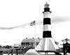 |
Lighthouse Bayou 29°43′0"N 93°51′0"W |
Cameron Cameron, Louisiana Cameron is a census-designated place in and the parish seat of Cameron Parish, Louisiana, United States. The population was 1,965 at the 2000 census. It is part of the Lake Charles Metropolitan Statistical Area... |
Catahoula ParishCatahoula Parish, LouisianaCatahoula Parish is a parish located in the U.S. state of Louisiana. Its seat is Harrisonburg, located on the Ouachita River, which forms the eastern boundary of the parish. In 2000, the population of the parish was 10,920.-Prehistory:...
| Landmark name | Image | Date listed | Location | City or Town | Summary | |
|---|---|---|---|---|---|---|
| 1 | Battleground Plantation | 4 miles (6.4 km) north of Sicily Island 31°53′45"N 91°39′23"W |
Sicily Island Sicily Island, Louisiana Sicily Island is a village in Catahoula Parish, Louisiana, United States. The population was 453 at the 2000 census.-Geography:Sicily Island is located at .... |
|||
| 2 | Caney Mounds | Address Restricted | Jonesville Jonesville, Louisiana Jonesville is a town in Catahoula Parish, Louisiana, at the confluence of the Ouachita, Tensas, and Little rivers. The three rivers become the Black River at Jonesville though the "Black" is primarily the continuation of the Ouachita River. A new bridge has been built over the Black River... |
|||
| 3 | Catahoula Parish Courthouse | Louisiana Highway 124 31°46′17"N 91°49′16"W |
Harrisonburg Harrisonburg, Louisiana Harrisonburg is a village in and the parish seat of Catahoula Parish, Louisiana, United States. The population was 746 at the 2000 census.- History :... |
|||
| 4 | Ferry Place | Address Restricted | Sicily Island Sicily Island, Louisiana Sicily Island is a village in Catahoula Parish, Louisiana, United States. The population was 453 at the 2000 census.-Geography:Sicily Island is located at .... |
|||
| 5 | Green-Lovelace House | North of Sicily Island off Louisiana Highway 15 Louisiana Highway 15 Louisiana Highway 15 is a state highway in Louisiana. It spans north/south for .-Route description:LA 15 begins as an exit from U.S. Route 167 just south of Lillie and heads due east towards Spearsville. From Spearsville, LA 15 turns to the southeast and shortly merges with LA 2 and LA 33 in... 31°52′33"N 91°39′36"W |
Sicily Island Sicily Island, Louisiana Sicily Island is a village in Catahoula Parish, Louisiana, United States. The population was 453 at the 2000 census.-Geography:Sicily Island is located at .... |
|||
| 6 | Hardin House | Louisiana Highway 913 north of its junction with Louisiana Highway 8 Louisiana Highway 8 Louisiana Highway 8 is a state highway in Louisiana. It spans beginning at the Louisiana/Texas state line and ending at an intersection with LA 15.-Route description:... 31°49′52"N 91°43′0"W |
Sicily Island Sicily Island, Louisiana Sicily Island is a village in Catahoula Parish, Louisiana, United States. The population was 453 at the 2000 census.-Geography:Sicily Island is located at .... |
|||
| 7 | Kirby House | Spencer and Pearl Sts. 31°37′53"N 91°48′43"W |
Trinity | |||
| 8 | Marengo Plantation House | U.S. Route 84 U.S. Route 84 U.S. Route 84 is an east–west United States highway. It started as a short Georgia-Alabama route in the original 1926 scheme, but now extends all the way to Colorado. The highway's eastern terminus is a short distance east of Midway, Georgia, at an intersection with I-95. The road continues... , 6 miles west of Jonesville 31°35′30"N 91°55′21"W |
Jonesville Jonesville, Louisiana Jonesville is a town in Catahoula Parish, Louisiana, at the confluence of the Ouachita, Tensas, and Little rivers. The three rivers become the Black River at Jonesville though the "Black" is primarily the continuation of the Ouachita River. A new bridge has been built over the Black River... |
|||
| 9 | Moss Grove Plantation House | 509 Black River Rd. 31°32′56"N 91°48′8"W |
Jonesville Jonesville, Louisiana Jonesville is a town in Catahoula Parish, Louisiana, at the confluence of the Ouachita, Tensas, and Little rivers. The three rivers become the Black River at Jonesville though the "Black" is primarily the continuation of the Ouachita River. A new bridge has been built over the Black River... |
|||
| 10 | Paul's Camp South | Address Restricted | Jonesville Jonesville, Louisiana Jonesville is a town in Catahoula Parish, Louisiana, at the confluence of the Ouachita, Tensas, and Little rivers. The three rivers become the Black River at Jonesville though the "Black" is primarily the continuation of the Ouachita River. A new bridge has been built over the Black River... |
|||
| 11 | Sargent House | Catahoula St. 31°46′18"N 91°49′10"W |
Harrisonburg Harrisonburg, Louisiana Harrisonburg is a village in and the parish seat of Catahoula Parish, Louisiana, United States. The population was 746 at the 2000 census.- History :... |
|||
| 12 | Spring Ridge Baptist Church | Sherwood Rd., near its junction with Louisiana Highways 124 and 559 31°50′3"N 91°57′57"W |
Enterprise | |||
| 13 | Wildwood | Off Louisiana Highway 15 Louisiana Highway 15 Louisiana Highway 15 is a state highway in Louisiana. It spans north/south for .-Route description:LA 15 begins as an exit from U.S. Route 167 just south of Lillie and heads due east towards Spearsville. From Spearsville, LA 15 turns to the southeast and shortly merges with LA 2 and LA 33 in... 31°48′42"N 91°34′31"W |
Sicily Island Sicily Island, Louisiana Sicily Island is a village in Catahoula Parish, Louisiana, United States. The population was 453 at the 2000 census.-Geography:Sicily Island is located at .... |
Claiborne ParishClaiborne Parish, LouisianaClaiborne Parish is a parish located in the U.S. state of Louisiana. The parish seat is Homer and as of 2000, the population is 16,851.-History:The parish is named for the first Louisiana governor, William C. C. Claiborne....
| Landmark name | Image | Date listed | Location | City or Town | Summary | |
|---|---|---|---|---|---|---|
| 1 | Arizona Methodist Church | Louisiana Highway 806 Louisiana Highway 806 Louisiana Highway 806 is a spur road that connects Louisiana Highway 2 with Arizona Road in Homer.-References:***... 32°47′17"N 92°57′26"W |
Arizona | |||
| 2 | J.W. Burnham House | Off U.S. Route 79 U.S. Route 79 U.S. Route 79 is a north–south United States highway. The route is a northeast-southwest diagonal, with both east–west segments and north–south segments equally mixed. The highway's northern terminus is in Russellville, Kentucky, at an intersection with U.S. Highway 68 and KY 80... 32°56′57"N 93°4′47"W |
Haynesville Haynesville, Louisiana Haynesville is a town in northern Claiborne Parish, Louisiana, United States, located just south of the Arkansas border. The population was 2,679 at the 2000 census.... |
|||
| 3 | Capers-McKenzie House | N. 5th St. 32°47′46"N 93°3′28"W |
Homer Homer, Louisiana Homer is present day parish seat of Claiborne Parish, Louisiana, United States. The town was named after the Greek poet Homer and was laid out around the Courthouse Square in 1850 by Frank Vaughn. The present day brick courthouse, built in the Greek Revival style of architecture, is one of only... |
|||
| 4 | Claiborne Parish Courthouse | Courthouse Sq. 32°47′28"N 93°3′18"W |
Homer Homer, Louisiana Homer is present day parish seat of Claiborne Parish, Louisiana, United States. The town was named after the Greek poet Homer and was laid out around the Courthouse Square in 1850 by Frank Vaughn. The present day brick courthouse, built in the Greek Revival style of architecture, is one of only... |
|||
| 5 | Homer Historic District | Roughly bounded by N. 2nd, E. Main, S. 3rd, and W. Main Sts. 32°47′28"N 93°3′18"W |
Homer Homer, Louisiana Homer is present day parish seat of Claiborne Parish, Louisiana, United States. The town was named after the Greek poet Homer and was laid out around the Courthouse Square in 1850 by Frank Vaughn. The present day brick courthouse, built in the Greek Revival style of architecture, is one of only... |
|||
| 6 | Killgore House | Junction of Louisiana Highways 2 Louisiana Highway 2 Louisiana Highway 2 is a state highway in the U.S. state of Louisiana. It runs in a west to east direction, beginning at State Highway 49 and ending at an intersection with U.S. Highway 65 in East Carroll Parish... and 518 32°47′44"N 92°52′19"W |
Lisbon Lisbon, Louisiana Lisbon is a village in Claiborne Parish, Louisiana, United States. The population was 162 at the 2000 census. Lisbon is located east of the parish seat of Homer.... |
|||
| 7 | Monk House | Louisiana Highway 9 Louisiana Highway 9 Louisiana Highway 9 is a state highway that serves Natchitoches Parish, Bienville Parish, and Claiborne Parish in north Louisiana. It spans , running a north–south route.-Route description:... and Claiborne Parish Route 39 32°53′21"N 92°57′55"W |
Homer Homer, Louisiana Homer is present day parish seat of Claiborne Parish, Louisiana, United States. The town was named after the Greek poet Homer and was laid out around the Courthouse Square in 1850 by Frank Vaughn. The present day brick courthouse, built in the Greek Revival style of architecture, is one of only... |
|||
| 8 | Dr. John W. Todd House | 306 Pine St. 32°47′24"N 93°2′49"W |
Homer Homer, Louisiana Homer is present day parish seat of Claiborne Parish, Louisiana, United States. The town was named after the Greek poet Homer and was laid out around the Courthouse Square in 1850 by Frank Vaughn. The present day brick courthouse, built in the Greek Revival style of architecture, is one of only... |
|||
| 9 | Tulip Methodist Church | Off Louisiana Highway 518 32°40′55"N 92°59′0"W |
Marsalis | |||
| 10 | Alberry Wasson Homeplace | 1½ miles south of Summerfield 32°53′40"N 92°50′28"W |
Summerfield Summerfield, Louisiana Summerfield is an unincorporated area in northeast Claiborne Parish, Louisiana, United States. It is located sixteen miles east of the parish seat of Homer.... |
Concordia ParishConcordia Parish, LouisianaConcordia Parish borders the Mississippi River in eastern Louisiana. The parish seat is Vidalia. As of 2000, the population was 20,247. It is part of the Natchez, MS–LA Micropolitan Statistical Area.-Prehistory:...
| Landmark name | Image | Date listed | Location | City or Town | Summary | |
|---|---|---|---|---|---|---|
| 1 | Sheriff Eugene P. Campbell House | 2 Concordia Ave. 31°33′50"N 91°25′27"W |
Vidalia Vidalia, Louisiana Vidalia is a city in and the parish seat of Concordia Parish, Louisiana, United States. The population was 4,543 at the 2000 census.- Geography :Vidalia is located at and has an elevation of .... |
|||
| 2 | Canebrake | Northeast of Ferriday on Louisiana Highway 901 31°41′56"N 91°24′40"W |
Ferriday Ferriday, Louisiana Ferriday is a town in Concordia Parish in northeastern Louisiana, United States. The population, which is three-fourths African American, was 3,723 at the 2000 census.... |
|||
| 3 | Concordia Parish Courthouse | 405 Carter St. 31°34′4"N 91°25′42"W |
Vidalia Vidalia, Louisiana Vidalia is a city in and the parish seat of Concordia Parish, Louisiana, United States. The population was 4,543 at the 2000 census.- Geography :Vidalia is located at and has an elevation of .... |
|||
| 4 | DePrato Mounds DePrato Mounds Deprato Mounds , also known as the Ferriday Mounds, is a multimound archaeological site located in Concordia Parish, Louisiana. The site shows occupation from the Troyville period to the Middle Coles Creek period . The largest mound at the site has been radiocarbon and decorated pottery dated to... |
Address Restricted | Ferriday Ferriday, Louisiana Ferriday is a town in Concordia Parish in northeastern Louisiana, United States. The population, which is three-fourths African American, was 3,723 at the 2000 census.... |
|||
| 5 | Ferriday Commercial Historic District | Roughly bounded by 1st St., Louisiana Ave., 3rd St., and Mississippi Ave. 31°37′44"N 91°33′9"W |
Ferriday Ferriday, Louisiana Ferriday is a town in Concordia Parish in northeastern Louisiana, United States. The population, which is three-fourths African American, was 3,723 at the 2000 census.... |
|||
| 6 | Frogmore | U.S. Route 84 U.S. Route 84 U.S. Route 84 is an east–west United States highway. It started as a short Georgia-Alabama route in the original 1926 scheme, but now extends all the way to Colorado. The highway's eastern terminus is a short distance east of Midway, Georgia, at an intersection with I-95. The road continues... 31°35′40"N 91°40′18"W |
Ferriday Ferriday, Louisiana Ferriday is a town in Concordia Parish in northeastern Louisiana, United States. The population, which is three-fourths African American, was 3,723 at the 2000 census.... |
|||
| 7 | Frogmore Mound Site Frogmore Mound Site Frogmore Mound Site is an archaeological site of the Late Coles Creek culture in Concordia Parish, Louisiana. It was added to the NRHP on July 28, 2004 as NRIS number 04000740.-Description:... |
Address Restricted | Frogmore | |||
| 8 | Killarney | 3908 Louisiana Highway 569 31°42′31"N 91°27′1"W |
Ferriday Ferriday, Louisiana Ferriday is a town in Concordia Parish in northeastern Louisiana, United States. The population, which is three-fourths African American, was 3,723 at the 2000 census.... |
|||
| 9 | Lisburn Plantation House | Southeast of Ferriday 31°39′19"N 91°28′30"W |
Ferriday Ferriday, Louisiana Ferriday is a town in Concordia Parish in northeastern Louisiana, United States. The population, which is three-fourths African American, was 3,723 at the 2000 census.... |
|||
| 10 | Piazza Cotton Gin | Frogmore Plantation-11656 U.S. Route 84 U.S. Route 84 U.S. Route 84 is an east–west United States highway. It started as a short Georgia-Alabama route in the original 1926 scheme, but now extends all the way to Colorado. The highway's eastern terminus is a short distance east of Midway, Georgia, at an intersection with I-95. The road continues... 31°36′21"N 91°40′10"W |
Ferriday Ferriday, Louisiana Ferriday is a town in Concordia Parish in northeastern Louisiana, United States. The population, which is three-fourths African American, was 3,723 at the 2000 census.... |
|||
| 11 | Roseland | 500 Fisherman Dr. 31°37′13"N 91°32′18"W |
Ferriday Ferriday, Louisiana Ferriday is a town in Concordia Parish in northeastern Louisiana, United States. The population, which is three-fourths African American, was 3,723 at the 2000 census.... |
|||
| 12 | Tacony Plantation House | Off U.S. Route 84 U.S. Route 84 U.S. Route 84 is an east–west United States highway. It started as a short Georgia-Alabama route in the original 1926 scheme, but now extends all the way to Colorado. The highway's eastern terminus is a short distance east of Midway, Georgia, at an intersection with I-95. The road continues... 31°34′50"N 91°28′21"W |
Vidalia Vidalia, Louisiana Vidalia is a city in and the parish seat of Concordia Parish, Louisiana, United States. The population was 4,543 at the 2000 census.- Geography :Vidalia is located at and has an elevation of .... |
|||
| 13 | Zappe Boarding House | 107 Virginia Ave. 31°38′6"N 91°33′7"W |
Ferriday Ferriday, Louisiana Ferriday is a town in Concordia Parish in northeastern Louisiana, United States. The population, which is three-fourths African American, was 3,723 at the 2000 census.... |
De Soto ParishDe Soto Parish, Louisiana-Demographics:As of the census of 2010, there were 26,656 people, 9,691 households, and 6,967 families residing in the parish. The population density was 29 people per square mile . There were 11,204 housing units at an average density of 13 per square mile...
East Baton Rouge ParishEast Baton Rouge Parish, LouisianaEast Baton Rouge Parish is a parish located in the U.S. state of Louisiana. The parish seat is Baton Rouge, Louisiana's state capital. As of the 2010 census, the population was 440,171. The parish has a total area of , of which is land and is water. It is the most populous parish in the state...
East Carroll ParishEast Carroll Parish, LouisianaEast Carroll Parish is a parish located in the U.S. state of Louisiana. The parish seat is Lake Providence and as of 2010, the population was 7,759.-Law and government:In the 2004 presidential race, East Carroll gave the George W. Bush - Richard B...
| Landmark name | Image | Date listed | Location | City or Town | Summary | |
|---|---|---|---|---|---|---|
| 1 | Arlington Plantation | 214 Arlington 32°48′53"N 91°10′34"W |
Lake Providence Lake Providence, Louisiana Lake Providence is a town in and the parish seat of East Carroll Parish, Louisiana, United States. The population was 5,104 at the 2000 census.-Civil War:... |
|||
| 2 | Buckmeadow Plantation House Buckmeadow Plantation House Buckmeadow Plantation House is located in Lake Providence, Louisiana. It was built in 1840 and added to the National Register of Historic Places on September 15, 1983.... |
Northwest of Lake Providence off Louisiana Highway 2 Louisiana Highway 2 Louisiana Highway 2 is a state highway in the U.S. state of Louisiana. It runs in a west to east direction, beginning at State Highway 49 and ending at an intersection with U.S. Highway 65 in East Carroll Parish... 32°51′14"N 91°14′19"W |
Lake Providence Lake Providence, Louisiana Lake Providence is a town in and the parish seat of East Carroll Parish, Louisiana, United States. The population was 5,104 at the 2000 census.-Civil War:... |
|||
| 3 | Byerley House | Junction of Lake and Ingram Sts. 32°48′22"N 91°10′30"W |
Lake Providence Lake Providence, Louisiana Lake Providence is a town in and the parish seat of East Carroll Parish, Louisiana, United States. The population was 5,104 at the 2000 census.-Civil War:... |
|||
| 4 | Fischer House | 15 Lake St. 32°48′34"N 91°11′9"W |
Lake Providence Lake Providence, Louisiana Lake Providence is a town in and the parish seat of East Carroll Parish, Louisiana, United States. The population was 5,104 at the 2000 census.-Civil War:... |
|||
| 5 | Lake Providence Historic District | Lake, Levee, and Scarborough Sts 32°48′17"N 91°10′12"W |
Lake Providence Lake Providence, Louisiana Lake Providence is a town in and the parish seat of East Carroll Parish, Louisiana, United States. The population was 5,104 at the 2000 census.-Civil War:... |
|||
| 6 | Lake Providence Residential Street Historic District | Lake and Davis Sts. 32°48′24"N 91°10′34"W |
Lake Providence Lake Providence, Louisiana Lake Providence is a town in and the parish seat of East Carroll Parish, Louisiana, United States. The population was 5,104 at the 2000 census.-Civil War:... |
|||
| 7 | Nelson House | 407 Davis St. 32°48′6"N 91°10′31"W |
Lake Providence Lake Providence, Louisiana Lake Providence is a town in and the parish seat of East Carroll Parish, Louisiana, United States. The population was 5,104 at the 2000 census.-Civil War:... |
|||
| 8 | Old Courthouse Square | 1st and Hoad Sts. 32°48′12"N 91°10′24"W |
Lake Providence Lake Providence, Louisiana Lake Providence is a town in and the parish seat of East Carroll Parish, Louisiana, United States. The population was 5,104 at the 2000 census.-Civil War:... |
East Feliciana ParishEast Feliciana Parish, LouisianaEast Feliciana Parish is a parish located in the U.S. state of Louisiana. The parish seat is Clinton. In 2000, the population was 21,360.East Feliciana Parish is part of the Baton Rouge Metropolitan Statistical Area as well as the Baton Rouge–Pierre Part Combined Statistical...
Evangeline ParishEvangeline Parish, Louisiana-Demographics:As of the census of 2000, there were 35,434 people, 12,736 households, and 9,157 families residing in the parish. The population density was 53 people per square mile . There were 14,258 housing units at an average density of 22 per square mile...
| Landmark name | Image | Date listed | Location | City or Town | Summary | |
|---|---|---|---|---|---|---|
| 1 | Bank of Ville Platte | 102 W. Main St. 30°41′17"N 92°16′28"W |
Ville Platte Ville Platte, Louisiana Ville Platte is a city in and the parish seat of Evangeline Parish, Louisiana, United States. The population was 8,145 at the 2000 census. Its name is derived from the French ville plate, or "flat town."-History:... |
|||
| 2 | Dardeau Building | 224 W. Main St. 30°41′20"N 92°16′34"W |
Ville Platte Ville Platte, Louisiana Ville Platte is a city in and the parish seat of Evangeline Parish, Louisiana, United States. The population was 8,145 at the 2000 census. Its name is derived from the French ville plate, or "flat town."-History:... |
|||
| 3 | Evangeline Bank and Trust Company | 342 W. Main St. 30°41′22"N 92°16′39"W |
Ville Platte Ville Platte, Louisiana Ville Platte is a city in and the parish seat of Evangeline Parish, Louisiana, United States. The population was 8,145 at the 2000 census. Its name is derived from the French ville plate, or "flat town."-History:... |
|||
| 4 | Jean Marie Laran House | 619 E. Main St. 30°41′10"N 92°16′4"W |
Ville Platte Ville Platte, Louisiana Ville Platte is a city in and the parish seat of Evangeline Parish, Louisiana, United States. The population was 8,145 at the 2000 census. Its name is derived from the French ville plate, or "flat town."-History:... |
|||
| 5 | Alexis LaTour House Alexis LaTour House The Alexis LaTour House also known as, "Old Homeplace; Guillory Homeplace is an historic house in Ville Platte, Louisiana. The oldest portion of the house was built in 1835 by Alexis LaTour. The house was expanded in 1837. The original house was a -story Creole cottage of bousillage construction... |
247 E. Main St. 30°41′13"N 92°16′13"W |
Ville Platte Ville Platte, Louisiana Ville Platte is a city in and the parish seat of Evangeline Parish, Louisiana, United States. The population was 8,145 at the 2000 census. Its name is derived from the French ville plate, or "flat town."-History:... |
|||
| 6 | Tate House | 1425 Louisiana Highway 29 Louisiana Highway 29 Louisiana Highway 29 is a state highway in Louisiana. It lasts .-Route description:LA 29 begins at a junction with LA 13 in Eunice and then heads northeastward through St. Landry Parish and Evangeline. LA 29 runs through Chataignier and Ville Platte while in Evangeline Parish. Upon entering St... 30°44′9"N 92°14′17"W |
Ville Platte Ville Platte, Louisiana Ville Platte is a city in and the parish seat of Evangeline Parish, Louisiana, United States. The population was 8,145 at the 2000 census. Its name is derived from the French ville plate, or "flat town."-History:... |
Franklin ParishFranklin Parish, Louisiana-Demographics:As of the census of 2000, there were 21,263 people, 7,754 households, and 5,706 families residing in the parish. The population density was 34 people per square mile . There were 8,623 housing units at an average density of 14 per square mile...
| Landmark name | Image | Date listed | Location | City or Town | Summary | |
|---|---|---|---|---|---|---|
| 1 | Baskin High School Building | Louisiana Highway 857 32°15′41"N 91°44′40"W |
Baskin Baskin, Louisiana Baskin is a village in Franklin Parish, Louisiana, United States. The population was 188 at the 2000 census. Baskin is located north of the parish seat of Winnsboro.-History:... |
|||
| 2 | Chennault House | Louisiana Highway 15 Louisiana Highway 15 Louisiana Highway 15 is a state highway in Louisiana. It spans north/south for .-Route description:LA 15 begins as an exit from U.S. Route 167 just south of Lillie and heads due east towards Spearsville. From Spearsville, LA 15 turns to the southeast and shortly merges with LA 2 and LA 33 in... south of Gilbert 32°2′43"N 91°39′26"W |
Gilbert Gilbert, Louisiana Gilbert is a village in Franklin Parish, Louisiana, United States. The population was 561 at the 2000 census.-History:The village is named for one of the early families of Franklin Parish. One of their descendants is former state legislator J.C... |
|||
| 3 | Grayson House | Southeast of Fort Necessity on Louisiana Highway 562 31°58′40"N 91°48′21"W |
Fort Necessity | |||
| 4 | Jackson House | 703 Jackson St. 32°9′58"N 91°42′50"W |
Winnsboro Winnsboro, Louisiana Winnsboro is a city in and the parish seat of Franklin Parish, Louisiana, United States. As of July 2009, the estimated city population was 4,377... |
|||
| 5 | Jackson Street Historic District | Jackson St. 32°9′58"N 91°42′49"W |
Winnsboro Winnsboro, Louisiana Winnsboro is a city in and the parish seat of Franklin Parish, Louisiana, United States. As of July 2009, the estimated city population was 4,377... |
|||
| 6 | Winnsboro Commercial Historic District | Prairie St. 32°9′49"N 91°43′10"W |
Winnsboro Winnsboro, Louisiana Winnsboro is a city in and the parish seat of Franklin Parish, Louisiana, United States. As of July 2009, the estimated city population was 4,377... |
Grant ParishGrant Parish, Louisiana-Demographics:As of the census of 2000, there were 18,698 people, 7,073 households, and 5,276 families residing in the parish. The population density was 29 people per square mile . There were 8,531 housing units at an average density of 13 per square mile...
| Landmark name | Image | Date listed | Location | City or Town | Summary | |
|---|---|---|---|---|---|---|
| 1 | Ethridge House | 401 Louise St. 31°31′16"N 92°42′49"W |
Colfax Colfax, Louisiana Colfax is a town in and the parish seat of Grant Parish, Louisiana, United States. The town, founded in 1869, is named for the vice president of the United States, Schuyler M. Colfax , who served in the first term of U.S. President Ulysses S. Grant, for whom the parish is named. Colfax is part of... |
|||
| 2 | Kateland | North of Boyce off Louisiana Highway 8 Louisiana Highway 8 Louisiana Highway 8 is a state highway in Louisiana. It spans beginning at the Louisiana/Texas state line and ending at an intersection with LA 15.-Route description:... 31°27′6"N 92°41′30"W |
Boyce Boyce, Louisiana Boyce is a town in northern Rapides Parish, Louisiana, United States. It is part of the Alexandria, Louisiana Metropolitan Statistical Area. The population was 1,190 at the 2000 census. The community is nearly 75 percent African American.-History:... |
|||
| 3 | McNeely House | 3rd, 4th, and Main Sts. 31°30′46"N 92°42′43"W |
Colfax Colfax, Louisiana Colfax is a town in and the parish seat of Grant Parish, Louisiana, United States. The town, founded in 1869, is named for the vice president of the United States, Schuyler M. Colfax , who served in the first term of U.S. President Ulysses S. Grant, for whom the parish is named. Colfax is part of... |
|||
| 4 | Earl Roberts House | 253 2nd St. 31°30′51"N 92°42′43"W |
Colfax Colfax, Louisiana Colfax is a town in and the parish seat of Grant Parish, Louisiana, United States. The town, founded in 1869, is named for the vice president of the United States, Schuyler M. Colfax , who served in the first term of U.S. President Ulysses S. Grant, for whom the parish is named. Colfax is part of... |
Iberia ParishIberia Parish, LouisianaIberia Parish is a parish located in the U.S. state of Louisiana. The parish seat is New Iberia. As of 2000, the population was 73,266.Iberia Parish is part of the New Iberia Micropolitan Statistical Area as well as the Lafayette–Acadiana Combined Statistical Area.Iberia, along with...
Iberville ParishIberville Parish, LouisianaIberville Parish is a parish located south of Baton Rouge in the U.S. state of Louisiana. Its seat is Plaquemine. The 2010 population of the parish was 33,387....
Jackson ParishJackson Parish, LouisianaJackson Parish is a parish located in the U.S. state of Louisiana. The parish was formed in 1845 from parts of Claiborne, Ouachita, and Union Parishes. In 2010, its population was 16,274. The parish seat is Jonesboro...
| Landmark name | Image | Date listed | Location | City or Town | Summary | |
|---|---|---|---|---|---|---|
| 1 | Brooklyn Church and Cemetery | Southeast of Chatham off Louisiana Highway 4 Louisiana Highway 4 Louisiana Highway 4 is a state highway in Louisiana, USA. It spans , mostly as a two lane, undivided road.-Route description:From the west, LA 4 begins at an intersection with U.S. Highway 71 in northern Red River Parish and runs eastward along the Red River Parish line. It then turns to the... 32°15′23"N 92°22′40"W |
Chatham Chatham, Louisiana Chatham is a town in Jackson Parish, Louisiana, United States. The population was 623 at the 2000 census. It is part of the Ruston Micropolitan Statistical Area.Southwest of Chatham is Caney Lake and the Jimmie Davis State Park.'-Geography:... |
|||
| 2 | Hickory Springs Methodist Episcopal Church | Off Louisiana Highway 499 near Bear Creek 32°10′35"N 92°19′3"W |
Chatham Chatham, Louisiana Chatham is a town in Jackson Parish, Louisiana, United States. The population was 623 at the 2000 census. It is part of the Ruston Micropolitan Statistical Area.Southwest of Chatham is Caney Lake and the Jimmie Davis State Park.'-Geography:... |
|||
| 3 | Palace Theatre | 125 Jimmy Davis Boulevard | Jonesboro Jonesboro, Louisiana Jonesboro is a town in and the parish seat of Jackson Parish in the northern portion of the U.S. state of Louisiana. The population was 3,914 at the 2000 census. It is part of the Ruston Micropolitan Statistical Area.-Geography:... |
|||
| 4 | Simms-Ellis House | Louisiana Highway 148 32°24′51"N 92°38′30"W |
Clay | |||
| 5 | Wilder House | Shell and Pine Sts. 32°18′25"N 92°26′27"W |
Chatham Chatham, Louisiana Chatham is a town in Jackson Parish, Louisiana, United States. The population was 623 at the 2000 census. It is part of the Ruston Micropolitan Statistical Area.Southwest of Chatham is Caney Lake and the Jimmie Davis State Park.'-Geography:... |
Jefferson ParishJefferson Parish, LouisianaJefferson Parish is a parish in Louisiana, United States that includes most of the suburbs of New Orleans. The seat of parish government is Gretna....
Jefferson Davis ParishJefferson Davis Parish, LouisianaJefferson Davis Parish is a parish located in the U.S. state of Louisiana. The parish seat is Jennings. As of 2000, its population was 31,435. Jefferson Davis Parish is named after the president of the Confederacy during the American Civil War, Jefferson Davis. It is located in southwestern...
La Salle ParishLa Salle Parish, LouisianaLa Salle Parish is a parish located in the U.S. state of Louisiana. As of 2000, the population was 14,282. The parish seat is Jena.-Geography:The parish has a total area of , of which is land and is water....
| Landmark name | Image | Date listed | Location | City or Town | Summary | |
|---|---|---|---|---|---|---|
| 1 | Good Pine Lumber Company Building | W. Bradford St. 31°41′27"N 92°8′54"W |
Good Pine | |||
| 2 | Trout-Good Pine School | School Rd. 31°41′27"N 92°10′3"W |
Good Pine | |||
| 3 | White Sulphur Springs | Southwest of Jena on Louisiana Highway 8 Louisiana Highway 8 Louisiana Highway 8 is a state highway in Louisiana. It spans beginning at the Louisiana/Texas state line and ending at an intersection with LA 15.-Route description:... 31°36′4"N 92°16′12"W |
Jena Jena, Louisiana Jena is a town in and the parish seat of La Salle Parish, Louisiana, United States. The population was 2,971 at the 2000 census.In September 2006, Jena became the focus of national news stories in the United States for a racial controversy involving its school system and a group of students known... |
Lafayette ParishLafayette Parish, LouisianaLafayette Parish is a parish located in the U.S. state of Louisiana. The parish seat is Lafayette. According to the 2010 Census, its population was recorded as 221,578....
Lafourche ParishLafourche Parish, LouisianaLafourche Parish is a parish located in the south of the U.S. state of Louisiana. It was originally the northern part of Lafourche Interior Parish, which consisted of the present parishes of Lafourche and Terrebonne. The parish seat is Thibodaux...
Lincoln ParishLincoln Parish, LouisianaLincoln Parish is a parish located in the U.S. state of Louisiana. The parish seat is Ruston. In 2004, its population was estimated to be 42,382...
Livingston ParishLivingston Parish, LouisianaLivingston Parish Is a parish located in the U.S. state of Louisiana. Its parish seat is Livingston. As of 2010, its population was 128,026....
| Landmark name | Image | Date listed | Location | City or Town | Summary | |
|---|---|---|---|---|---|---|
| 1 | Carter Plantation | Southwest of Springfield on Louisiana Highway 1038 30°24′38"N 90°34′47"W |
Springfield Springfield, Louisiana Springfield is a town in Livingston Parish, Louisiana, United States. The population was 395 at the 2000 census. It is part of the Baton Rouge Metropolitan Statistical Area.-Geography:Springfield is located at .... |
|||
| 2 | Castleberry Boarding House | 18290 Cooper St. 30°19′56"N 90°51′0"W |
Port Vincent Port Vincent, Louisiana Port Vincent is a village in Livingston Parish, Louisiana, United States. The population was 463 at the 2000 census. It is part of the Baton Rouge Metropolitan Statistical Area.-Geography:Port Vincent is located at .... |
|||
| 3 | Decareaux House | 16021 Louisiana Highway 16 Louisiana Highway 16 Louisiana Highway 16 is a state highway in Louisiana. It runs from west to east for .-Route description:From the east, LA 16 begins in Sun at a junction with LA 21 and heads west northwest into Washington Parish. At an intersection with LA 60, LA 16 turns north-northwest towards Franklinton, where... 30°17′53"N 90°47′56"W |
French Settlement French Settlement, Louisiana French Settlement is a village in Livingston Parish, Louisiana, United States. The population was 945 at the 2000 census. It is part of the Baton Rouge Metropolitan Statistical Area.-History:... |
|||
| 4 | Denham Springs City Hall Denham Springs City Hall The Denham Springs City Hall was listed in the National Register of Historic Places listings in Louisiana on April 16, 1993. It was constructed in the late 1930s by the WPA and last used in the 1980s. A complete restoration, costing some $695,000, was completed in late 2008 and rededication... |
115 Mattie St. 30°29′7"N 90°57′24"W |
Denham Springs Denham Springs, Louisiana Denham Springs is a city in Livingston Parish, Louisiana, United States, and part of the Baton Rouge Metropolitan Statistical Area. Downtown Denham Springs has transformed itself from hardware stores, drug stores, doctor's offices, and a single movie theater to a collection of various and varied... |
|||
| 5 | Deslattes House | 15620 Louisiana Highway 16 Louisiana Highway 16 Louisiana Highway 16 is a state highway in Louisiana. It runs from west to east for .-Route description:From the east, LA 16 begins in Sun at a junction with LA 21 and heads west northwest into Washington Parish. At an intersection with LA 60, LA 16 turns north-northwest towards Franklinton, where... 30°17′38"N 90°47′39"W |
French Settlement French Settlement, Louisiana French Settlement is a village in Livingston Parish, Louisiana, United States. The population was 945 at the 2000 census. It is part of the Baton Rouge Metropolitan Statistical Area.-History:... |
|||
| 6 | Guitreau House | 16825 Louisiana Highway 16 Louisiana Highway 16 Louisiana Highway 16 is a state highway in Louisiana. It runs from west to east for .-Route description:From the east, LA 16 begins in Sun at a junction with LA 21 and heads west northwest into Washington Parish. At an intersection with LA 60, LA 16 turns north-northwest towards Franklinton, where... 30°19′17"N 90°48′36"W |
French Settlement French Settlement, Louisiana French Settlement is a village in Livingston Parish, Louisiana, United States. The population was 945 at the 2000 census. It is part of the Baton Rouge Metropolitan Statistical Area.-History:... |
|||
| 7 | Hungarian Settlement School | Louisiana Highway 43 and Presbyterian Church Rd. 30°28′9"N 90°34′43"W |
Albany Albany, Louisiana Albany is a village in Livingston Parish, Louisiana, United States. The population was 865 at the 2000 census. It is part of the Baton Rouge Metropolitan Statistical Area.-History:... |
|||
| 8 | Adam Lobell House | 15715 Louisiana Highway 16 Louisiana Highway 16 Louisiana Highway 16 is a state highway in Louisiana. It runs from west to east for .-Route description:From the east, LA 16 begins in Sun at a junction with LA 21 and heads west northwest into Washington Parish. At an intersection with LA 60, LA 16 turns north-northwest towards Franklinton, where... 30°17′39"N 90°47′45"W |
French Settlement French Settlement, Louisiana French Settlement is a village in Livingston Parish, Louisiana, United States. The population was 945 at the 2000 census. It is part of the Baton Rouge Metropolitan Statistical Area.-History:... |
|||
| 9 | Macedonia Baptist Church Macedonia Baptist Church (Holden, Louisiana) The Macedonia Baptist Church in Holden, Louisiana is within the Livingston Parish and was organized in 1856. The current building was constructed in 1898. The local community was settled by Protestants during the 19th century.... |
North of Holden 30°35′31"N 90°39′8"W |
Holden Holden, Louisiana Holden is located on U.S. Highway 190 between Albany and Livingston in Livingston Parish, Louisiana, United States. Holden is in a section of land awarded to Micajah Spillars by a Spanish land grant. LA Hwy 441 which runs through Holden in a northwest-southeast direction is the road that connected... |
|||
| 10 | Old Livingston Parish Courthouse | 2nd and Mulberry Sts. 30°25′42"N 90°32′46"W |
Springfield Springfield, Louisiana Springfield is a town in Livingston Parish, Louisiana, United States. The population was 395 at the 2000 census. It is part of the Baton Rouge Metropolitan Statistical Area.-Geography:Springfield is located at .... |
|||
| 11 | St. Margaret Catholic Church | Junction of Interstate 12 Interstate 12 Interstate 12 is an intrastate Interstate Highway located entirely within the state of Louisiana. I-12 starts in Baton Rouge at Interstate 10, and travels along the North Shore of Lake Pontchartrain before ending at the intersection of Interstate 10 and Interstate 59 near Slidell... and Louisiana Highway 43 30°28′24"N 90°34′49"W |
Albany Albany, Louisiana Albany is a village in Livingston Parish, Louisiana, United States. The population was 865 at the 2000 census. It is part of the Baton Rouge Metropolitan Statistical Area.-History:... |
|||
| 12 | Walker High School | 13443 Burgess Ave. 30°29′21"N 90°51′47"W |
Walker Walker, Louisiana Walker is a town in Livingston Parish, Louisiana, United States. The population was 4,801 at the 2000 census. It is part of the Baton Rouge Metropolitan Statistical Area... |
Madison ParishMadison Parish, Louisiana-National protected areas:* Tensas River National Wildlife Refuge * Vicksburg National Military Park -Demographics:-2010:Whereas according to the 2010 U.S...
| Landmark name | Image | Date listed | Location | City or Town | Summary | |
|---|---|---|---|---|---|---|
| 1 | Bear Lake Club, Ltd. Clubhouse | Parish Road 39 near its junction with Bear Lake and Roundaway Bayou 32°28′2"N 91°16′2"W |
Tallulah Tallulah, Louisiana Tallulah is a city in and the parish seat of Madison Parish, Louisiana, United States. The population was 9,189 at the 2000 census... |
|||
| 2 | Bloom's Arcade | 102 Depot St. 32°24′33"N 91°11′29"W |
Tallulah Tallulah, Louisiana Tallulah is a city in and the parish seat of Madison Parish, Louisiana, United States. The population was 9,189 at the 2000 census... |
|||
| 3 | Crescent Plantation Crescent Plantation Crescent Plantation is located in Tallulah, Louisiana. It was built in 1859 and was added to the National Register of Historic Places on October 18, 1984.... |
South of Tallulah off Louisiana Highway 602 32°22′7"N 91°9′52"W |
Tallulah Tallulah, Louisiana Tallulah is a city in and the parish seat of Madison Parish, Louisiana, United States. The population was 9,189 at the 2000 census... |
|||
| 4 | Hermione Hermione (Tallulah, Louisiana) Hermione is a Greek Revival building built in 1855 in Tallulah, Louisiana.In April 1862, General Grant's troops landed at Milliken's Bend before the siege of Vicksburg and occupied the Sparta Plantation... |
307 N. Mulberry St. 32°24′34"N 91°11′5"W |
Tallulah Tallulah, Louisiana Tallulah is a city in and the parish seat of Madison Parish, Louisiana, United States. The population was 9,189 at the 2000 census... |
|||
| 5 | Kell House | 502 N. Mulberry St. 32°24′39"N 91°11′0"W |
Tallulah Tallulah, Louisiana Tallulah is a city in and the parish seat of Madison Parish, Louisiana, United States. The population was 9,189 at the 2000 census... |
|||
| 6 | Madison Parish Courthouse | Junction of U.S. Routes 65 U.S. Route 65 U.S. Route 65 is a north–south United States highway in the southern and midwestern United States. The southern terminus of the route is at U.S. Route 425 in Clayton, Louisiana. The northern terminus is at Interstate 35 just south of Interstate 90 in Albert Lea, Minnesota... and 80 U.S. Route 80 U.S. Route 80 is an east–west United States highway, much of which was once part of the early auto trail known as the Dixie Overland Highway. As the "0" in the route number indicates, it was originally a cross-country route, from the Atlantic to the Pacific... 32°24′28"N 91°11′15"W |
Tallulah Tallulah, Louisiana Tallulah is a city in and the parish seat of Madison Parish, Louisiana, United States. The population was 9,189 at the 2000 census... |
|||
| 7 | Mississippi River Bridge |  |
Spans the Mississippi River Mississippi River The Mississippi River is the largest river system in North America. Flowing entirely in the United States, this river rises in western Minnesota and meanders slowly southwards for to the Mississippi River Delta at the Gulf of Mexico. With its many tributaries, the Mississippi's watershed drains... on Old U.S. Route 80 U.S. Route 80 U.S. Route 80 is an east–west United States highway, much of which was once part of the early auto trail known as the Dixie Overland Highway. As the "0" in the route number indicates, it was originally a cross-country route, from the Atlantic to the Pacific... 32°18′54"N 90°54′20"W |
Delta Delta, Louisiana Delta is a village in Madison Parish, Louisiana, United States. The population was 239 at the 2000 census. It is part of the Tallulah Micropolitan Statistical Area.As the birthplace of Madam C.J... |
Extends into Warren County, Mississippi National Register of Historic Places listings in Warren County, Mississippi This is a list of the National Register of Historic Places listings in Warren County, Mississippi.This is intended to be a complete list of the properties and districts on the National Register of Historic Places in Warren County, Mississippi, United States... |
|
| 8 | Montrose Plantation House Montrose Plantation House Montrose Plantation House is located in Tallulah, Louisiana. It was added to the National Register of Historic Places on October 5, 1982.... |
Southeast of Tallulah on Louisiana Highway 603 32°19′25"N 91°8′22"W |
Tallulah Tallulah, Louisiana Tallulah is a city in and the parish seat of Madison Parish, Louisiana, United States. The population was 9,189 at the 2000 census... |
|||
| 9 | Scottland Plantation House Scottland Plantation House Scottland Plantation House is located in Tallulah, Louisiana. It was built in 1860 and was added to the National Register of Historic Places on November 2, 1982.... |
903 Bayou Dr. 32°24′8"N 91°11′44"W |
Tallulah Tallulah, Louisiana Tallulah is a city in and the parish seat of Madison Parish, Louisiana, United States. The population was 9,189 at the 2000 census... |
|||
| 10 | Shirley Field | Off U.S. Route 80 U.S. Route 80 U.S. Route 80 is an east–west United States highway, much of which was once part of the early auto trail known as the Dixie Overland Highway. As the "0" in the route number indicates, it was originally a cross-country route, from the Atlantic to the Pacific... 32°24′57"N 91°8′58"W |
Tallulah Tallulah, Louisiana Tallulah is a city in and the parish seat of Madison Parish, Louisiana, United States. The population was 9,189 at the 2000 census... |
|||
| 11 | Tallulah Book Club Building | 515 Dabney St. 32°24′20"N 91°11′13"W |
Tallulah Tallulah, Louisiana Tallulah is a city in and the parish seat of Madison Parish, Louisiana, United States. The population was 9,189 at the 2000 census... |
|||
| 12 | Tallulah Men's Club Building | 108 N. Cedar St. 32°24′28"N 91°11′12"W |
Tallulah Tallulah, Louisiana Tallulah is a city in and the parish seat of Madison Parish, Louisiana, United States. The population was 9,189 at the 2000 census... |
|||
| 13 | Francis Thompson Site (16 MA 112) | Address Restricted | Delhi Delhi, Louisiana Delhi, originally called Deerfield, is a town in Richland Parish, Louisiana, in the United States. As of the 2000 census, the town population was 3,066.-History:... |
Morehouse ParishMorehouse Parish, LouisianaMorehouse Parish is a parish located in the U.S. state of Louisiana. The parish seat is Bastrop. In 2000, the parish population was 31,021....
| Landmark name | Image | Date listed | Location | City or Town | Summary | |
|---|---|---|---|---|---|---|
| 1 | Bastrop High School | 715 S. Washington St. 32°46′18"N 91°54′49"W |
Bastrop Bastrop, Louisiana Bastrop is a city in and the parish seat of Morehouse Parish, Louisiana, United States. The population was 12,988 at the 2000 census. It is the principal city of and is included in the Bastrop, Louisiana Micropolitan Statistical Area, which is included in the Monroe-Bastrop, Louisiana Combined... |
|||
| 2 | Cedars Plantation | 3 miles west of Oak Ridge on Louisiana Highway 5503 32°36′56"N 91°48′46"W |
Oak Ridge Oak Ridge, Louisiana Oak Ridge is a village in Morehouse Parish, Louisiana, United States. The population was 142 at the 2000 census. It is part of the Bastrop Micropolitan Statistical Area.-Geography:Oak Ridge is located at .... |
|||
| 3 | Christ Episcopal Church | 206 S. Locust 32°46′37"N 91°55′2"W |
Bastrop Bastrop, Louisiana Bastrop is a city in and the parish seat of Morehouse Parish, Louisiana, United States. The population was 12,988 at the 2000 census. It is the principal city of and is included in the Bastrop, Louisiana Micropolitan Statistical Area, which is included in the Monroe-Bastrop, Louisiana Combined... |
|||
| 4 | Excelsior | Louisiana Highway 133 32°37′28"N 91°46′25"W |
Oak Ridge Oak Ridge, Louisiana Oak Ridge is a village in Morehouse Parish, Louisiana, United States. The population was 142 at the 2000 census. It is part of the Bastrop Micropolitan Statistical Area.-Geography:Oak Ridge is located at .... |
|||
| 5 | Mer Rouge High School | 500 S. 14th St. 32°46′19"N 91°47′44"W |
Mer Rouge Mer Rouge, Louisiana Mer Rouge is a village in Morehouse Parish, Louisiana, United States. The name is French for "Red Sea". The population was 721 at the 2000 census. It is part of the Bastrop Micropolitan Statistical Area.... |
|||
| 6 | Morehouse Parish Courthouse | 125 E. Madison 32°46′39"N 91°54′49"W |
Bastrop Bastrop, Louisiana Bastrop is a city in and the parish seat of Morehouse Parish, Louisiana, United States. The population was 12,988 at the 2000 census. It is the principal city of and is included in the Bastrop, Louisiana Micropolitan Statistical Area, which is included in the Monroe-Bastrop, Louisiana Combined... |
|||
| 7 | Rose Theatre | U.S. Route 165 U.S. Route 165 U.S. Route 165 is a north–south United States highway spur of U.S. Highway 65. It currently runs for 412 miles from U.S. Route 90 in Iowa, Louisiana north to U.S. Highway 70 in North Little Rock, Arkansas. The route passes through the states of Arkansas and Louisiana. It passes through the... 32°46′41"N 91°54′51"W |
Bastrop Bastrop, Louisiana Bastrop is a city in and the parish seat of Morehouse Parish, Louisiana, United States. The population was 12,988 at the 2000 census. It is the principal city of and is included in the Bastrop, Louisiana Micropolitan Statistical Area, which is included in the Monroe-Bastrop, Louisiana Combined... |
|||
| 8 | Snyder House | 1610 E. Madison-U.S. Route 165 U.S. Route 165 U.S. Route 165 is a north–south United States highway spur of U.S. Highway 65. It currently runs for 412 miles from U.S. Route 90 in Iowa, Louisiana north to U.S. Highway 70 in North Little Rock, Arkansas. The route passes through the states of Arkansas and Louisiana. It passes through the... 32°46′46"N 91°53′45"W |
Bastrop Bastrop, Louisiana Bastrop is a city in and the parish seat of Morehouse Parish, Louisiana, United States. The population was 12,988 at the 2000 census. It is the principal city of and is included in the Bastrop, Louisiana Micropolitan Statistical Area, which is included in the Monroe-Bastrop, Louisiana Combined... |
|||
| 9 | Walnut Grove | 9069 Oak Ridge Rd. 32°45′25"N 91°47′11"W |
Mer Rouge Mer Rouge, Louisiana Mer Rouge is a village in Morehouse Parish, Louisiana, United States. The name is French for "Red Sea". The population was 721 at the 2000 census. It is part of the Bastrop Micropolitan Statistical Area.... |
Natchitoches ParishNatchitoches Parish, LouisianaNatchitoches Parish is a parish located in the U.S. state of Louisiana. The parish seat is Natchitoches. As of 2000, the population was 39,080. This is the heart of the Cane River Louisiana Creole community...
Orleans Parish
Ouachita ParishOuachita Parish, Louisiana-National protected areas:* Black Bayou Lake National Wildlife Refuge* D'Arbonne National Wildlife Refuge -Demographics:As of the census of 2000, there were 147,250 people, 55,216 households, and 38,319 families residing in the parish. The population density was 241 people per square mile...
Plaquemines ParishPlaquemines Parish, LouisianaPlaquemines Parish is the parish with the most combined land and water area in the U.S. state of Louisiana. The parish seat is Pointe à la Hache...
| Landmark name | Image | Date listed | Location | City or Town | Summary | |
|---|---|---|---|---|---|---|
| 1 | Fort De La Boulaye Site Fort De La Boulaye Site Fort De La Boulaye Site, also known as Mississippi Fort is the site of a fort built by the French in 1700, to take possession of the Mississippi. Native Americans forced the French to vacate the fort by 1707.... |
Eastern bank of the Mississippi River Mississippi River The Mississippi River is the largest river system in North America. Flowing entirely in the United States, this river rises in western Minnesota and meanders slowly southwards for to the Mississippi River Delta at the Gulf of Mexico. With its many tributaries, the Mississippi's watershed drains... , along Louisiana Highway 39 Louisiana Highway 39 Louisiana Highway 39 is a state highway in Louisiana that serves Orleans, St. Bernard, and Plaquemines Parishes. In New Orleans, LA 39 is referred to as North Claiborne Avenue, while in St. Bernard Parish, it is known as Judge Perez Drive... 29°38′57"N 89°56′40"W |
Phoenix Phoenix, Louisiana Phoenix is an unincorporated community Plaquemines Parish, Louisiana.Phoenix is located on the east bank of the Mississippi River on Louisiana Highway 39, on the opposite side of the river from Myrtle Grove.... |
|||
| 2 | Fort Jackson Fort Jackson, Louisiana Fort Jackson is a decommissioned masonry fort located some up river from the mouth of the Mississippi River in Plaquemines Parish, Louisiana. It was constructed as a coastal defense of New Orleans between 1822 and 1832, and was a battle site in the American Civil War. It is a National Historic... |
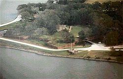 |
2.5 miles southeast of Triumph on Louisiana Highway 23 Louisiana Highway 23 Louisiana Highway 23 is a north–south state highway in Louisiana that serves Plaquemines and Jefferson Parishes. It spans 74.02 miles in roughly a southeast/northwest direction. It is known locally as Belle Chasse Highway, Lafayette Street, the West Bank Expressway, and Franklin... on the western bank of the Mississippi River Mississippi River The Mississippi River is the largest river system in North America. Flowing entirely in the United States, this river rises in western Minnesota and meanders slowly southwards for to the Mississippi River Delta at the Gulf of Mexico. With its many tributaries, the Mississippi's watershed drains... 29°21′22"N 89°27′18"W |
Triumph Triumph, Louisiana Triumph is an unincorporated community in Plaquemines Parish, Louisiana, United States. It is located on the south bank of the Mississippi River.... |
||
| 3 | Fort St. Philip Fort St. Philip Fort St. Philip is a decommissioned masonry fort located on the eastern bank of the Mississippi River, about up river from its mouth in Plaquemines Parish, Louisiana... |
2.5 miles southeast of Triumph on Louisiana Highway 23 Louisiana Highway 23 Louisiana Highway 23 is a north–south state highway in Louisiana that serves Plaquemines and Jefferson Parishes. It spans 74.02 miles in roughly a southeast/northwest direction. It is known locally as Belle Chasse Highway, Lafayette Street, the West Bank Expressway, and Franklin... on the eastern bank of the Mississippi River Mississippi River The Mississippi River is the largest river system in North America. Flowing entirely in the United States, this river rises in western Minnesota and meanders slowly southwards for to the Mississippi River Delta at the Gulf of Mexico. With its many tributaries, the Mississippi's watershed drains... 29°21′45"N 89°27′58"W |
Triumph Triumph, Louisiana Triumph is an unincorporated community in Plaquemines Parish, Louisiana, United States. It is located on the south bank of the Mississippi River.... |
|||
| 4 | Harlem Plantation House Harlem Plantation House Harlem Plantation House is located on Louisiana Highway 39 between Davant and Phoenix, Plaquemines Parish, Louisiana, on the East Bank of the Mississippi River up from Pointe a la Hache, Louisiana. It was built in 1840 and added to the National Register of Historic Places on October 26, 1982. It... |
West of Pointe à la Hache on Louisiana Highway 39 Louisiana Highway 39 Louisiana Highway 39 is a state highway in Louisiana that serves Orleans, St. Bernard, and Plaquemines Parishes. In New Orleans, LA 39 is referred to as North Claiborne Avenue, while in St. Bernard Parish, it is known as Judge Perez Drive... 29°37′28"N 89°54′10"W |
Pointe à la Hache Pointe a la Hache, Louisiana Pointe à la Hache is an unincorporated village and place in Plaquemines Parish, Louisiana, United States.Located on the east bank of the Mississippi River, the village has been the seat for Plaquemines Parish since the formation of the parish.... |
|||
| 5 | Mary Plantation House Mary Plantation House Mary Plantation House is located in Braithwaite, Louisiana. It was built in 1820 and was added to the National Register of Historic Places on July 13, 1983.... |
Louisiana Highway 39 Louisiana Highway 39 Louisiana Highway 39 is a state highway in Louisiana that serves Orleans, St. Bernard, and Plaquemines Parishes. In New Orleans, LA 39 is referred to as North Claiborne Avenue, while in St. Bernard Parish, it is known as Judge Perez Drive... 29°48′15"N 89°59′59"W |
Braithwaite | |||
| 6 | Promised Land | 5907 Louisiana Highway 39 Louisiana Highway 39 Louisiana Highway 39 is a state highway in Louisiana that serves Orleans, St. Bernard, and Plaquemines Parishes. In New Orleans, LA 39 is referred to as North Claiborne Avenue, while in St. Bernard Parish, it is known as Judge Perez Drive... 29°47′43"N 90°0′15"W |
Braithwaite | |||
| 7 | St. Patrick's Catholic Church | 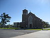 |
21997 Louisiana Highway 23 Louisiana Highway 23 Louisiana Highway 23 is a north–south state highway in Louisiana that serves Plaquemines and Jefferson Parishes. It spans 74.02 miles in roughly a southeast/northwest direction. It is known locally as Belle Chasse Highway, Lafayette Street, the West Bank Expressway, and Franklin... 29°27′9"N 89°37′34"W |
West Pointe à la Hache West Pointe à la Hache, Louisiana West Pointe à la Hache is an unincorporated community in Plaquemines Parish, Louisiana, United States, on the west bank of the Mississippi River... |
||
| 8 | Woodland Plantation Woodland Plantation (West Pointe a la Hache, Louisiana) Woodland Plantation, in West Pointe à la Hache, Louisiana, is the mansion depicted in A Home on the Mississippi, an 1871 lithograph which later was licensed for use on the label of Southern Comfort after prohibition ended... |
 |
21997 Louisiana Highway 23 Louisiana Highway 23 Louisiana Highway 23 is a north–south state highway in Louisiana that serves Plaquemines and Jefferson Parishes. It spans 74.02 miles in roughly a southeast/northwest direction. It is known locally as Belle Chasse Highway, Lafayette Street, the West Bank Expressway, and Franklin... 29°35′8"N 89°49′34"W |
West Pointe à la Hache West Pointe à la Hache, Louisiana West Pointe à la Hache is an unincorporated community in Plaquemines Parish, Louisiana, United States, on the west bank of the Mississippi River... |
Pointe Coupee ParishPointe Coupee Parish, LouisianaPointe Coupee Parish, pronounced "Pwent Koo-Pay" and , is a parish located in the U.S. state of Louisiana. The parish seat is New Roads. As of 2000, the population was 22,763....
Rapides ParishRapides Parish, Louisiana-Military Installations:*Camp Beauregard *Esler Airfield *England Air Force Base *Camp Claiborne *Camp Livingston -Demographics:...
Red River ParishRed River Parish, LouisianaRed River Parish is a parish located in the U.S. state of Louisiana. Its seat is Coushatta. It was one of the newer parishes created in 1871 by the state legislature under Reconstruction...
| Landmark name | Image | Date listed | Location | City or Town | Summary | |
|---|---|---|---|---|---|---|
| 1 | Coushatta Bank Building | 103 Carroll St. 32°0′30"N 93°21′4"W |
Coushatta Coushatta, Louisiana Coushatta is a town in and the parish seat of rural Red River Parish, Louisiana, United States. It is situated on the east bank of the Red River. The community is approximately forty-five miles south of Shreveport on U.S. Highway 71... |
|||
| 2 | Planter's Hotel | Carroll St. 32°1′18"N 93°21′2"W |
Coushatta Coushatta, Louisiana Coushatta is a town in and the parish seat of rural Red River Parish, Louisiana, United States. It is situated on the east bank of the Red River. The community is approximately forty-five miles south of Shreveport on U.S. Highway 71... |
|||
| 3 | Thomas House | Louisiana Highway 787 32°4′21"N 93°10′51"W |
Martin Martin, Louisiana Martin is a village in Red River Parish, Louisiana, United States. The population was 625 at the 2000 census.-History:The Reverend John Dupree organized sixteen Baptist churches in Louisiana east of the Red River. where his work began in 1862. Earlier, he had organized congregations in Georgia. He... |
Richland ParishRichland Parish, LouisianaRichland Parish is a parish located in the U.S. state of Louisiana. The parish seat is Rayville. As of 2010, the population was 20,725.-History:...
| Landmark name | Image | Date listed | Location | City or Town | Summary | |
|---|---|---|---|---|---|---|
| 1 | Delhi Municipal Baseball Park | Chicago and Louisiana Sts. 32°27′19"N 91°29′48"W |
Delhi Delhi, Louisiana Delhi, originally called Deerfield, is a town in Richland Parish, Louisiana, in the United States. As of the 2000 census, the town population was 3,066.-History:... |
|||
| 2 | Downtown Delhi Historic District | 606-708 1st St. and 115-201 Broadway 32°27′26"N 91°29′36"W |
Delhi Delhi, Louisiana Delhi, originally called Deerfield, is a town in Richland Parish, Louisiana, in the United States. As of the 2000 census, the town population was 3,066.-History:... |
|||
| 3 | Mangham State Bank Building | Main and Horace Sts. 32°18′29"N 91°46′33"W |
Mangham Mangham, Louisiana Mangham is a village in Richland Parish in northeastern Louisiana, United States. The population was 595 at the 2000 census. Mangham was established in 1890. It is named for Wyley P... |
|||
| 4 | Miles-Hanna House | 206 Charter 32°27′31"N 91°29′36"W |
Delhi Delhi, Louisiana Delhi, originally called Deerfield, is a town in Richland Parish, Louisiana, in the United States. As of the 2000 census, the town population was 3,066.-History:... |
|||
| 5 | Poplar Chapel AME Church | Louisiana Highway 135 32°23′55"N 91°50′2"W |
Rayville Rayville, Louisiana Rayville is a town in, the parish seat of, and the largest community in Richland Parish in northeastern Louisiana, United States. The population was 4,234 at the 2000 census. It is also home of Palmetto Addiction Recovery Center... |
|||
| 6 | Rayville High School | 109 Madeline St. 32°28′33"N 91°45′25"W |
Rayville Rayville, Louisiana Rayville is a town in, the parish seat of, and the largest community in Richland Parish in northeastern Louisiana, United States. The population was 4,234 at the 2000 census. It is also home of Palmetto Addiction Recovery Center... |
|||
| 7 | Nonnie Roark Rhymes Memorial Library | 206 S. Louisa St. 32°28′31"N 91°45′25"W |
Rayville Rayville, Louisiana Rayville is a town in, the parish seat of, and the largest community in Richland Parish in northeastern Louisiana, United States. The population was 4,234 at the 2000 census. It is also home of Palmetto Addiction Recovery Center... |
|||
| 8 | St. David's Episcopal Church | 834 Louisa St. 32°28′27"N 91°45′29"W |
Rayville Rayville, Louisiana Rayville is a town in, the parish seat of, and the largest community in Richland Parish in northeastern Louisiana, United States. The population was 4,234 at the 2000 census. It is also home of Palmetto Addiction Recovery Center... |
|||
| 9 | Trio Plantation House | 312 Trio Rd. 32°32′0"N 91°43′7"W |
Rayville Rayville, Louisiana Rayville is a town in, the parish seat of, and the largest community in Richland Parish in northeastern Louisiana, United States. The population was 4,234 at the 2000 census. It is also home of Palmetto Addiction Recovery Center... |
|||
| 10 | Vickers House | Louisiana Highway 15 Louisiana Highway 15 Louisiana Highway 15 is a state highway in Louisiana. It spans north/south for .-Route description:LA 15 begins as an exit from U.S. Route 167 just south of Lillie and heads due east towards Spearsville. From Spearsville, LA 15 turns to the southeast and shortly merges with LA 2 and LA 33 in... 32°21′27"N 91°51′37"W |
Alto |
Sabine ParishSabine Parish, LouisianaSabine Parish is a parish located in the U.S. state of Louisiana. The seat of the parish is Many. In 2010, the parish's population was 24,233....
| Landmark name | Image | Date listed | Location | City or Town | Summary | |
|---|---|---|---|---|---|---|
| 1 | Fisher Historic District | Roughly bounded by 4 L Dr., 3rd Ave., and S. 2nd and North Sts. 31°29′36"N 93°27′54"W |
Fisher Fisher, Louisiana Fisher is a village in Sabine Parish, Louisiana, United States. The population was 268 at the 2000 census.-History:Fisher was named for Oliver Williams Fisher and built between 1899 and 1901 by the Louisiana Long Leaf Lumber Company... |
|||
| 2 | Fort Jesup Fort Jesup Fort Jesup, also known as Fort Jesup State Historic Site or Fort Jessup or Fort Jesup State Monument, was built in 1822, 22 miles west of Natchitoches, Louisiana, to protect the United States border with Spain and to return order to the Neutral Strip. Originally named Cantonment Jesup, the fort... |
7 miles northeast of Many on Louisiana Highway 6 Louisiana Highway 6 Louisiana Highway 6 is a state highway in Louisiana. It spans and serves Sabine Parish and Natchitoches Parish.-Route description:... at Fort Jesup State Monument 31°36′41"N 93°24′3"W |
Many Many, Louisiana Many is a town in and the parish seat of Sabine Parish, Louisiana, United States. The population was 2,889 at the 2000 census. The town was named for John B. Many, the commander of nearby Fort Jesup.-History:... |
|||
| 3 | Kansas City Southern Depot, Zwolle | Spanish and Port Arthur Sts. 31°37′50"N 93°38′36"W |
Zwolle Zwolle, Louisiana Zwolle is a town in Sabine Parish, Louisiana, United States. The population was 1,783 at the 2000 census.-History:The first inhabitants of the bowl shaped area of land upon which the town of Zwolle is situated were the Mound Builders. Lured here for protection from storms, the "bowl" offered them... |
|||
| 4 | Kansas City Southern Railway Depot | 750 W. Georgia Ave. 31°33′56"N 93°29′3"W |
Many Many, Louisiana Many is a town in and the parish seat of Sabine Parish, Louisiana, United States. The population was 2,889 at the 2000 census. The town was named for John B. Many, the commander of nearby Fort Jesup.-History:... |
|||
| 5 | McNeely Hotel | 690 San Antonio Ave. 31°34′5"N 93°29′2"W |
Many Many, Louisiana Many is a town in and the parish seat of Sabine Parish, Louisiana, United States. The population was 2,889 at the 2000 census. The town was named for John B. Many, the commander of nearby Fort Jesup.-History:... |
|||
| 6 | J.M. Miller and Brother Store | 7886 Louisiana Highway 473 31°18′8"N 93°32′8"W |
Florien Florien, Louisiana Florien is a village in Sabine Parish, Louisiana, United States. The population was 692 at the 2000 census.-Geography:Florien is located at .According to the United States Census Bureau, the village has a total area of , all land.... |
|||
| 7 | Stoker House | Northeast of Many 31°37′25"N 93°23′7"W |
Many Many, Louisiana Many is a town in and the parish seat of Sabine Parish, Louisiana, United States. The population was 2,889 at the 2000 census. The town was named for John B. Many, the commander of nearby Fort Jesup.-History:... |
St. Bernard ParishSt. Bernard Parish, LouisianaSt. Bernard Parish is a parish located southeast of New Orleans in the U.S. state of Louisiana. The parish seat is Chalmette, the largest city in the parish. As of 2000, its population was 67,229. It has been ranked the fastest-growing county in the United States from 2007 to 2008 by the U.S....
| Landmark name | Image | Date listed | Location | City or Town | Summary | |
|---|---|---|---|---|---|---|
| 1 | Chalmette Unit of Jean Lafitte National Historical Park Historic District | 6 miles south of New Orleans 29°56′31"N 89°59′26"W |
New Orleans New Orleans, Louisiana New Orleans is a major United States port and the largest city and metropolitan area in the state of Louisiana. The New Orleans metropolitan area has a population of 1,235,650 as of 2009, the 46th largest in the USA. The New Orleans – Metairie – Bogalusa combined statistical area has a population... |
|||
| 2 | Chandeleur Light | Breton National Wildlife Refuge Breton National Wildlife Refuge Breton National Wildlife Refuge is located in southeastern Louisiana in the offshore Breton Islands and Chandeleur Islands. It is located in the Gulf of Mexico and is accessible only by boat... 30°2′52"N 88°52′18"W |
New Orleans New Orleans, Louisiana New Orleans is a major United States port and the largest city and metropolitan area in the state of Louisiana. The New Orleans metropolitan area has a population of 1,235,650 as of 2009, the 46th largest in the USA. The New Orleans – Metairie – Bogalusa combined statistical area has a population... |
|||
| 3 | Fort Proctor Fort Proctor Fort Proctor is a ruined 19th century fort in St. Bernard Parish, Louisiana. Also known as Fort Beauregard or Beauregard's Castle is located on the shore of Lake Borgne just north of the mouth of Bayou Yscolskey... |
 |
North of Shell Beach on Lake Borgne 29°52′2"N 89°40′42"W |
Shell Beach | ||
| 4 | Friscoville Street Historic District | 100-900 blocks of Friscoville St. 29°57′1"N 90°0′4"W |
Arabi Arabi, Louisiana Arabi is a census-designated place in St. Bernard Parish, Louisiana on the East Bank of the Mississippi River, between the Lower 9th Ward of New Orleans, Louisiana and Chalmette within the Greater New Orleans Metropolitan area... |
|||
| 5 | Kenilworth Plantation House | 2931 Bayou Rd. 29°52′2"N 89°48′51"W |
St. Bernard | |||
| 6 | Magnolia Mound | Address Restricted | St. Bernard | |||
| 7 | Old Arabi Historic District | 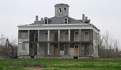 |
Roughly along parts of Angela, Mehle, and Esteban Sts. 29°57′6"N 90°0′28"W |
Arabi Arabi, Louisiana Arabi is a census-designated place in St. Bernard Parish, Louisiana on the East Bank of the Mississippi River, between the Lower 9th Ward of New Orleans, Louisiana and Chalmette within the Greater New Orleans Metropolitan area... |
||
| 8 | Sebastopol Plantation House | Louisiana Highway 46 Louisiana Highway 46 Louisiana Highway 46 is a state highway in Louisiana that serves Orleans and St. Bernard Parishes. It runs a west to east direction for a total length of . It is demarcated as Elysian Fields Avenue and St. Claude Avenue in the city of New Orleans and as St. Bernard Highway, Bayou Road, East Judge... 29°52′4"N 89°52′21"W |
St. Bernard |
St. Charles ParishSt. Charles Parish, LouisianaSt. Charles Parish is a parish located in the U.S. state of Louisiana. The parish seat is Hahnville. In 2010, its population was 52,780. In the eighteenth and nineteenth century, this was part of the German Coast, an area along the Mississippi River settled by numerous German pioneers in the...
| Landmark name | Image | Date listed | Location | City or Town | Summary | |
|---|---|---|---|---|---|---|
| 1 | Destrehan Plantation Destrehan Plantation Destrehan Plantation is an antebellum Greek Revival house located near Destrehan, St. Charles Parish, Louisiana. In the nineteenth century, the house was the center of a bustling slave plantation that produced sugar for export. The site hosted the notorious St... |
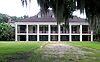 |
River Rd. (Louisiana Highway 48 Louisiana Highway 48 Louisiana Highway 48 is a state highway in Louisiana that serves St. Charles and Jefferson Parishes. It runs from west to east, parallel to the east bank of the Mississippi River, from Norco to Metairie. It spans a total of... ) 29°56′43"N 90°21′55"W |
Destrehan Destrehan, Louisiana Destrehan is a census-designated place in St. Charles Parish, Louisiana, United States. The population was 11,260 at the 2000 census. It was named after Jean N... |
||
| 2 | Dorvin House | Louisiana Highway 18 Louisiana Highway 18 Louisiana Highway 18 is a state highway in Louisiana that serves Ascension, St. James, St. John the Baptist, St. Charles, and Jefferson Parishes. Called the Great River Road, it runs from west to east, parallel to the west bank of the Mississippi River, running from Donaldsonville to Gretna. It... northwest of Hahnville 29°59′18"N 90°25′15"W |
Hahnville Hahnville, Louisiana Hahnville is a census-designated place in and the parish seat of St. Charles Parish, Louisiana, United States. The population was 2,792 at the 2000 census... |
|||
| 3 | Homeplace Plantation House Homeplace Plantation House Homeplace Plantation House, also known as Keller Homestead, is a National Historic Landmark in St. Charles Parish, Louisiana.Erected 1787-1791, this is an excellent example of a large French Colonial, two-story, raised cottage. The first-story walls are brick, while the second-story walls made of... |
.jpg) |
Louisiana Highway 18 Louisiana Highway 18 Louisiana Highway 18 is a state highway in Louisiana that serves Ascension, St. James, St. John the Baptist, St. Charles, and Jefferson Parishes. Called the Great River Road, it runs from west to east, parallel to the west bank of the Mississippi River, running from Donaldsonville to Gretna. It... , 0.5 miles south of Hahnville 29°58′12"N 90°24′32"W |
Hahnville Hahnville, Louisiana Hahnville is a census-designated place in and the parish seat of St. Charles Parish, Louisiana, United States. The population was 2,792 at the 2000 census... |
||
| 4 | Kenner and Kugler Cemeteries Archeological District | Address Restricted | Norco Norco, Louisiana Norco is a census-designated place in St. Charles Parish, Louisiana, United States. The population was 3,579 at the 2000 census. The community is home to a major Shell petroleum refinery. Its name is derived from the New Orleans Refining Company.... |
|||
| 5 | LaBranche Plantation Dependency | Southwest of Kenner off Louisiana Highway 48 Louisiana Highway 48 Louisiana Highway 48 is a state highway in Louisiana that serves St. Charles and Jefferson Parishes. It runs from west to east, parallel to the east bank of the Mississippi River, from Norco to Metairie. It spans a total of... 29°57′0"N 90°18′58"W |
Kenner Kenner, Louisiana Kenner is a city in Jefferson Parish, Louisiana, United States, and a suburb of New Orleans. The population was 66,702 at the 2010 census.... |
|||
| 6 | Ormond Plantation House | Junction of Louisiana Highway 48 Louisiana Highway 48 Louisiana Highway 48 is a state highway in Louisiana that serves St. Charles and Jefferson Parishes. It runs from west to east, parallel to the east bank of the Mississippi River, from Norco to Metairie. It spans a total of... and Oak Ave. 29°57′15"N 90°23′13"W |
Destrehan Destrehan, Louisiana Destrehan is a census-designated place in St. Charles Parish, Louisiana, United States. The population was 11,260 at the 2000 census. It was named after Jean N... |
St. Helena ParishSt. Helena Parish, LouisianaSt. Helena Parish is a parish in the U.S. state of Louisiana. Its seat is Greensburg. As of 2000, its population was 10,525.St. Helena Parish is part of the Baton Rouge Metropolitan Statistical Area as well as the Baton Rouge–Pierre Part Combined Statistical Area.-History:For the past...
| Landmark name | Image | Date listed | Location | City or Town | Summary | |
|---|---|---|---|---|---|---|
| 1 | Greensburg Land Office | Courthouse Sq. 30°49′44"N 90°40′1"W |
Greensburg Greensburg, Louisiana Greensburg is a town in and the parish seat of St. Helena Parish, Louisiana, United States. The population was 631 at the 2000 census. It is part of the Baton Rouge Metropolitan Statistical Area. Greensburg is one of the oldest towns in Louisiana.... |
|||
| 2 | Old St. Helena Parish Jail | Off Louisiana Highway 10 Louisiana Highway 10 Louisiana Highway 10 is a state highway in south-central Louisiana. It runs from west to east for . The western terminus is at the intersection of U.S. Route 171 in Pickering, Louisiana in Vernon Parish near Fort Polk and the eastern terminus is in Bogalusa at Pearl River and the Louisiana line... 30°49′44"N 90°40′1"W |
Greensburg Greensburg, Louisiana Greensburg is a town in and the parish seat of St. Helena Parish, Louisiana, United States. The population was 631 at the 2000 census. It is part of the Baton Rouge Metropolitan Statistical Area. Greensburg is one of the oldest towns in Louisiana.... |
St. James Parish
St. John the Baptist ParishSt. John the Baptist Parish, LouisianaSt. John the Baptist Parish is a parish located in the U.S. state of Louisiana.The parish seat is Edgard, an unincorporated area and the unofficial parish captial is LaPlace, an unincorporated area. St. John the Baptist is one of the original 19 parishes in Louisiana. In 2010, its population was...
St. Landry ParishSt. Landry Parish, LouisianaSt. Landry Parish is a parish located in the U.S. state of Louisiana. It is at the heart of Acadian/Cajun culture and heritage in Louisiana. The parish seat is Opelousas. According to the 2010 census, the population of St. Landry Parish is 83,384.St...
St. Martin ParishSt. Martin Parish, LouisianaSt. Martin Parish is a parish located in the U.S. state of Louisiana. The parish seat is St. Martinville. As of the 2000 census, the population was 48,583.St...
St. Mary ParishSt. Mary Parish, LouisianaSt. Mary Parish is a parish located in the U.S. state of Louisiana. The parish seat is Franklin. As of 2000, the population was 53,500.The Morgan City Micropolitan Statistical Area includes all of St. Mary Parish.-Geography:...
St. Tammany ParishSt. Tammany Parish, LouisianaSt. Tammany Parish is a parish located in the U.S. state of Louisiana, in the New Orleans–Metairie–Kenner Metropolitan Statistical Area. The parish seat is Covington....
Tangipahoa ParishTangipahoa Parish, LouisianaTangipahoa Parish is a parish located in the U.S. state of Louisiana, one of the Florida Parishes. The parish seat is Amite City, but the major city is Hammond. As of 2006, the population was 113,137...
Tensas ParishTensas Parish, LouisianaTensas Parish is a parish located in the U.S. state of Louisiana. The seat of the parish is St. Joseph. In 2010, the population of Tensas Parish was 5,252; it is the least-populous of all sixty-four parishes....
| Landmark name | Image | Date listed | Location | City or Town | Summary | |
|---|---|---|---|---|---|---|
| 1 | Bank of Newellton | 207 N. Main St. 32°4′38"N 91°14′8"W |
Newellton Newellton, Louisiana Newellton is a town in northern Tensas Parish in the northeastern part of the U.S. state of Louisiana. The population is 1,227 in the 2010 census, a decline of 255 from 2000. Newellton is some 65 percent African American. It is just west of the Mississippi River on Lake St. Joseph, an ox-bow lake.... |
|||
| 2 | The Burn | North of Waterproof off Louisiana Highway 65 31°50′26"N 91°23′8"W |
Waterproof Waterproof, Louisiana Waterproof is a town in Tensas Parish, Louisiana, United States with a population of 834 as of 2000 census. Waterproof is approximately seventeen miles north of Ferriday, one of the two principal communities of Concordia Parish... |
|||
| 3 | Lakewood | North of St. Joseph on Louisiana Highway 606 31°57′57"N 91°12′30"W |
St. Joseph St. Joseph, Louisiana St. Joseph is a town in and the parish seat of Tensas Parish in northeastern Louisiana, United States. The population was 1,340 at the 2000 census. The town is 69 percent African American. St. Joseph is the entry community to Lake Bruin State Park located on Lake Bruin, a relatively clear oxbow... |
|||
| 4 | Linwood Plantation Manager's House | Louisiana Highway 608 5 miles southeast of Newellton 32°1′42"N 91°10′36"W |
Newellton Newellton, Louisiana Newellton is a town in northern Tensas Parish in the northeastern part of the U.S. state of Louisiana. The population is 1,227 in the 2010 census, a decline of 255 from 2000. Newellton is some 65 percent African American. It is just west of the Mississippi River on Lake St. Joseph, an ox-bow lake.... |
|||
| 5 | Moro Plantation House Moro Plantation House Moro Plantation House is located near Waterproof, Louisiana. It was built in 1839 and was added to the National Register of Historic Places on October 5, 1982.... |
West of Waterproof off Louisiana Highway 566 31°48′54"N 91°25′55"W |
Waterproof Waterproof, Louisiana Waterproof is a town in Tensas Parish, Louisiana, United States with a population of 834 as of 2000 census. Waterproof is approximately seventeen miles north of Ferriday, one of the two principal communities of Concordia Parish... |
|||
| 6 | Myrtle Grove Plantation | Louisiana Highway 568 31°48′47"N 91°22′7"W |
Waterproof Waterproof, Louisiana Waterproof is a town in Tensas Parish, Louisiana, United States with a population of 834 as of 2000 census. Waterproof is approximately seventeen miles north of Ferriday, one of the two principal communities of Concordia Parish... |
|||
| 7 | St. Joseph Historic District | Roughly bounded by Panola Ave. and Front, Hickory, 4th, and Pauline Sts. 31°54′58"N 91°14′10"W |
St. Joseph St. Joseph, Louisiana St. Joseph is a town in and the parish seat of Tensas Parish in northeastern Louisiana, United States. The population was 1,340 at the 2000 census. The town is 69 percent African American. St. Joseph is the entry community to Lake Bruin State Park located on Lake Bruin, a relatively clear oxbow... |
|||
| 8 | Tensas Parish Courthouse | Courthouse Sq. 31°54′48"N 91°14′9"W |
St. Joseph St. Joseph, Louisiana St. Joseph is a town in and the parish seat of Tensas Parish in northeastern Louisiana, United States. The population was 1,340 at the 2000 census. The town is 69 percent African American. St. Joseph is the entry community to Lake Bruin State Park located on Lake Bruin, a relatively clear oxbow... |
|||
| 9 | Waterproof High School |  |
Main St., between Church Ln. and Mississippi St. 31°48′36"N 91°22′48"W |
Waterproof Waterproof, Louisiana Waterproof is a town in Tensas Parish, Louisiana, United States with a population of 834 as of 2000 census. Waterproof is approximately seventeen miles north of Ferriday, one of the two principal communities of Concordia Parish... |
||
| 10 | Winter Quarters Winter Quarters State Historic Site Winter Quarters in Tensas Parish, Louisiana, United States, is a surviving example of an Antebellum cotton plantation. It is located south of Newellton on Lake St. Joseph, an ox-bow lake, or former bend in the Mississippi River. The main plantation home of the site began as a hunting lodge in 1805... |
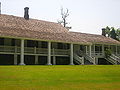 |
6 miles (9.6 km) southeast of Newellton on Louisiana Highway 608 32°1′6"N 91°9′35"W |
Newellton Newellton, Louisiana Newellton is a town in northern Tensas Parish in the northeastern part of the U.S. state of Louisiana. The population is 1,227 in the 2010 census, a decline of 255 from 2000. Newellton is some 65 percent African American. It is just west of the Mississippi River on Lake St. Joseph, an ox-bow lake.... |
Terrebonne ParishTerrebonne Parish, LouisianaTerrebonne Parish is a parish located in the U.S. state of Louisiana. The parish seat is Houma. Its population was 111,860...
Union ParishUnion Parish, LouisianaUnion Parish is a parish located in the U.S. state of Louisiana. The parish seat is Farmerville....
| Landmark name | Image | Date listed | Location | City or Town | Summary | |
|---|---|---|---|---|---|---|
| 1 | Alabama Methodist Church | Alternate Louisiana Highway 2 Louisiana Highway 2 Louisiana Highway 2 is a state highway in the U.S. state of Louisiana. It runs in a west to east direction, beginning at State Highway 49 and ending at an intersection with U.S. Highway 65 in East Carroll Parish... 32°51′35"N 92°43′31"W |
Bernice Bernice, Louisiana Bernice is a town in Union Parish, Louisiana, United States. The population was 1,809 at the 2000 census. It is part of the Monroe Metropolitan Statistical Area.-History:... |
|||
| 2 | Bernice Civic Clubhouse | Louisiana Highway 2 Louisiana Highway 2 Louisiana Highway 2 is a state highway in the U.S. state of Louisiana. It runs in a west to east direction, beginning at State Highway 49 and ending at an intersection with U.S. Highway 65 in East Carroll Parish... 32°49′17"N 92°39′5"W |
Bernice Bernice, Louisiana Bernice is a town in Union Parish, Louisiana, United States. The population was 1,809 at the 2000 census. It is part of the Monroe Metropolitan Statistical Area.-History:... |
|||
| 3 | Dual State Monument | Union County Road 86 33°0′39"N 92°22′5"W |
Marion Marion, Louisiana Marion is a town in Union Parish, Louisiana, United States. The population was 806 at the 2000 census. It is part of the Monroe Metropolitan Statistical Area.-Geography:Marion is located at .... |
Extends into Union County, Arkansas National Register of Historic Places listings in Union County, Arkansas This is a list of the National Register of Historic Places listings in Union County, Arkansas.This is intended to be a complete list of the properties and districts on the National Register of Historic Places in Union County, Arkansas, United States... |
||
| 4 | Edgewood | 1 mile west of Farmerville on the Bernice Highway 32°47′12"N 92°25′30"W |
Farmerville Farmerville, Louisiana Farmerville is a town in and the parish seat of Union Parish, Louisiana, United States. The population was 3,808 at the 2000 census. It is part of the Monroe Metropolitan Statistical Area... |
|||
| 5 | Garland House | 701 Cherry St. 32°49′3"N 92°39′27"W |
Bernice Bernice, Louisiana Bernice is a town in Union Parish, Louisiana, United States. The population was 1,809 at the 2000 census. It is part of the Monroe Metropolitan Statistical Area.-History:... |
|||
| 6 | J.W. Heard House | 605 Cherry St. 32°49′5"N 92°39′28"W |
Bernice Bernice, Louisiana Bernice is a town in Union Parish, Louisiana, United States. The population was 1,809 at the 2000 census. It is part of the Monroe Metropolitan Statistical Area.-History:... |
|||
| 7 | Hopkins House | Hopkins Lane 32°54′10"N 92°14′25"W |
Marion Marion, Louisiana Marion is a town in Union Parish, Louisiana, United States. The population was 806 at the 2000 census. It is part of the Monroe Metropolitan Statistical Area.-Geography:Marion is located at .... |
|||
| 8 | Lindsey Bonded Warehouses | Holly and 2nd Sts. 32°49′28"N 92°39′18"W |
Bernice Bernice, Louisiana Bernice is a town in Union Parish, Louisiana, United States. The population was 1,809 at the 2000 census. It is part of the Monroe Metropolitan Statistical Area.-History:... |
|||
| 9 | R.T. Moore House | Northern side of Alternate Louisiana Highway 2 Louisiana Highway 2 Louisiana Highway 2 is a state highway in the U.S. state of Louisiana. It runs in a west to east direction, beginning at State Highway 49 and ending at an intersection with U.S. Highway 65 in East Carroll Parish... , about 2 miles west of U.S. Route 167 U.S. Route 167 U.S. Route 167 runs for 499 miles from Ash Flat, Arkansas at U.S. Route 62 to Abbeville, Louisiana at Louisiana Highway 14. It goes through the cities of Little Rock, Arkansas, Alexandria, Louisiana, and Lafayette, Louisiana.... 32°50′40"N 92°40′52"W |
Bernice Bernice, Louisiana Bernice is a town in Union Parish, Louisiana, United States. The population was 1,809 at the 2000 census. It is part of the Monroe Metropolitan Statistical Area.-History:... |
|||
| 10 | Daniel Stein House | 208 W. Bayou 32°46′31"N 92°24′29"W |
Farmerville Farmerville, Louisiana Farmerville is a town in and the parish seat of Union Parish, Louisiana, United States. The population was 3,808 at the 2000 census. It is part of the Monroe Metropolitan Statistical Area... |
|||
| 11 | Dr. Terral Clinic | 107 N. Washington St. 32°46′27"N 92°24′16"W |
Farmerville Farmerville, Louisiana Farmerville is a town in and the parish seat of Union Parish, Louisiana, United States. The population was 3,808 at the 2000 census. It is part of the Monroe Metropolitan Statistical Area... |
Vermilion ParishVermilion Parish, LouisianaVermilion Parish is a parish located in the U.S. state of Louisiana. The parish seat is Abbeville. As of the 2010 census, the population was 57,999....
Vernon ParishVernon Parish, LouisianaVernon Parish is a parish located in the U.S. state of Louisiana. The parish seat is Leesville and as of 2000, the population was 52,531....
Washington ParishWashington Parish, LouisianaWashington Parish is a parish located in the U.S. state of Louisiana. Its parish seat is Franklinton. In 2000, its population was 43,926....
Webster ParishWebster Parish, LouisianaWebster Parish is a parish located in the U.S. state of Louisiana. The seat of the parish is Minden. In 2010, its population was 41,207....
West Baton Rouge ParishWest Baton Rouge Parish, LouisianaWest Baton Rouge Parish is one of the sixty-four parishes in the U.S. state of Louisiana, and is the smallest in total area. The parish seat is Port Allen and as of 2010, the population was 23,788. The parish has a highly-rated school system and is one of the few in Louisiana that has privatized...
| Landmark name | Image | Date listed | Location | City or Town | Summary | |
|---|---|---|---|---|---|---|
| 1 | Aillet House | 845 N. Jefferson Ave. 30°27′35"N 91°12′22"W |
Port Allen Port Allen, Louisiana Port Allen is a city in and the parish seat of West Baton Rouge Parish, Louisiana, United States. Port Allen is located between Interstate 10 and US Highway 190 on the West bank of the Mississippi River. The population was 5,180 at the 2010 census... |
|||
| 2 | Allendale Plantation Historic District | Junction of N. River Rd. and Allendale Rd. 30°29′45"N 91°16′24"W |
Port Allen Port Allen, Louisiana Port Allen is a city in and the parish seat of West Baton Rouge Parish, Louisiana, United States. Port Allen is located between Interstate 10 and US Highway 190 on the West bank of the Mississippi River. The population was 5,180 at the 2010 census... |
|||
| 3 | Antonia | 4626 S. River Rd. | Port Allen Port Allen, Louisiana Port Allen is a city in and the parish seat of West Baton Rouge Parish, Louisiana, United States. Port Allen is located between Interstate 10 and US Highway 190 on the West bank of the Mississippi River. The population was 5,180 at the 2010 census... |
(Louisiana's French Creole Architecture MPS) | ||
| 4 | Bank of Addis | 7843 Ray Rivet St. 30°21′16"N 91°15′59"W |
Addis Addis, Louisiana Addis is a town in West Baton Rouge Parish, Louisiana, United States. The population was 2,238 at the 2000 census. It is part of the Baton Rouge Metropolitan Statistical Area.-Geography:Addis is located at .... |
|||
| 5 | Cinclare Sugar Mill Historic District | Junction of Louisiana Highway 1 Louisiana Highway 1 Louisiana Highway 1 is a state highway in Louisiana. At 436.20 miles , it is the longest numbered highway of any class in Louisiana. It runs diagonally across the state, connecting the oil and gas fields near the island of Grand Isle with the northwest corner of the state, north of Shreveport.The... and Terrell Dr. 30°23′46"N 91°13′55"W |
Brusly Brusly, Louisiana Brusly is a town in West Baton Rouge Parish, Louisiana, United States. The population was 2,589 at the 2010 census. It is part of the Baton Rouge Metropolitan Statistical Area.- History :... |
|||
| 6 | Cohn High School | 805 N. 14th St. 30°27′34"N 91°13′5"W |
Port Allen Port Allen, Louisiana Port Allen is a city in and the parish seat of West Baton Rouge Parish, Louisiana, United States. Port Allen is located between Interstate 10 and US Highway 190 on the West bank of the Mississippi River. The population was 5,180 at the 2010 census... |
|||
| 7 | Hebert House | 919 E. Main St. 30°23′13"N 91°14′2"W |
Brusly Brusly, Louisiana Brusly is a town in West Baton Rouge Parish, Louisiana, United States. The population was 2,589 at the 2010 census. It is part of the Baton Rouge Metropolitan Statistical Area.- History :... |
|||
| 8 | Monte Vista Plantation House | North of Port Allen 30°30′10"N 91°12′11"W |
Port Allen Port Allen, Louisiana Port Allen is a city in and the parish seat of West Baton Rouge Parish, Louisiana, United States. Port Allen is located between Interstate 10 and US Highway 190 on the West bank of the Mississippi River. The population was 5,180 at the 2010 census... |
|||
| 9 | Old Brusly High School Gymnasium | 601 N. Kirkland Dr. 30°23′24"N 91°13′58"W |
Brusly Brusly, Louisiana Brusly is a town in West Baton Rouge Parish, Louisiana, United States. The population was 2,589 at the 2010 census. It is part of the Baton Rouge Metropolitan Statistical Area.- History :... |
|||
| 10 | Poplar Grove Plantation House | 3142 N. River Rd. 30°29′35"N 91°12′9"W |
Port Allen Port Allen, Louisiana Port Allen is a city in and the parish seat of West Baton Rouge Parish, Louisiana, United States. Port Allen is located between Interstate 10 and US Highway 190 on the West bank of the Mississippi River. The population was 5,180 at the 2010 census... |
|||
| 11 | Port Allen High School | 610 Rosedale St. 30°27′50"N 91°12′26"W |
Port Allen Port Allen, Louisiana Port Allen is a city in and the parish seat of West Baton Rouge Parish, Louisiana, United States. Port Allen is located between Interstate 10 and US Highway 190 on the West bank of the Mississippi River. The population was 5,180 at the 2010 census... |
|||
| 12 | Sandbar Plantation House | 4234 S. River Rd. 30°24′31"N 91°13′2"W |
Port Allen Port Allen, Louisiana Port Allen is a city in and the parish seat of West Baton Rouge Parish, Louisiana, United States. Port Allen is located between Interstate 10 and US Highway 190 on the West bank of the Mississippi River. The population was 5,180 at the 2010 census... |
|||
| 13 | Smithfield Plantation House | 12445 N. River Rd. 30°32′59"N 91°17′27"W |
Port Allen Port Allen, Louisiana Port Allen is a city in and the parish seat of West Baton Rouge Parish, Louisiana, United States. Port Allen is located between Interstate 10 and US Highway 190 on the West bank of the Mississippi River. The population was 5,180 at the 2010 census... |
West Carroll ParishWest Carroll Parish, LouisianaWest Carroll Parish is a parish located in the U.S. state of Louisiana. The parish seat is Oak Grove and as of 2000, the population was 12,314.-History:...
| Landmark name | Image | Date listed | Location | City or Town | Summary | |
|---|---|---|---|---|---|---|
| 1 | Marsden Mounds Marsden Mounds Marsden Mounds is an archaeological site with components from the Poverty Point culture and the Troyville-Coles Creek period . It is located in Richland Parish, Louisiana near Delhi It was added to the NRHP on August 4, 2004 as NRIS number 04000803... |
Poverty Point Parkway 32°29′10.8996"N 91°29′29.997"W |
Delhi Delhi, Louisiana Delhi, originally called Deerfield, is a town in Richland Parish, Louisiana, in the United States. As of the 2000 census, the town population was 3,066.-History:... |
A multimound archaeological site Archaeological site An archaeological site is a place in which evidence of past activity is preserved , and which has been, or may be, investigated using the discipline of archaeology and represents a part of the archaeological record.Beyond this, the definition and geographical extent of a 'site' can vary widely,... near Delhi, Louisiana Delhi, Louisiana Delhi, originally called Deerfield, is a town in Richland Parish, Louisiana, in the United States. As of the 2000 census, the town population was 3,066.-History:... , with a Poverty Point Poverty Point culture Poverty Point culture is an archaeological culture that corresponds to an ancient group of Indigenous peoples who inhabited the area of the lower Mississippi Valley and surrounding Gulf coast from about 2200 BCE - 700 BCE... period component (1500 BCE) and a Coles Creek Coles Creek culture Coles Creek culture is a Late Woodland archaeological culture in the Lower Mississippi valley in the southern United States. It followed the Troyville culture. The period marks a significant change in the cultural history of the area... component (400 to 1200 CE). |
||
| 2 | Poverty Point National Monument Poverty Point Poverty Point is a prehistoric earthworks of the Poverty Point culture, now a historic monument located in the Southern United States. It is from the current Mississippi River, and situated on the edge of Maçon Ridge, near the village of Epps in West Carroll Parish, Louisiana.Poverty Point... |
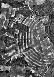 |
12 miles north of Delhi on Bayou Macon | Delhi Delhi, Louisiana Delhi, originally called Deerfield, is a town in Richland Parish, Louisiana, in the United States. As of the 2000 census, the town population was 3,066.-History:... |
The type site Type site In archaeology a type site is a site that is considered the model of a particular archaeological culture... for the Poverty Point culture]], a large complex of earthworks built between 1650 and 700 BCE, during the Archaic period.The site has six large concentric curving earthworks and several large mound Mound A mound is a general term for an artificial heaped pile of earth, gravel, sand, rocks, or debris. The most common use is in reference to natural earthen formation such as hills and mountains, particularly if they appear artificial. The term may also be applied to any rounded area of topographically... s. |
West Feliciana ParishWest Feliciana Parish, Louisiana-Demographics:As of the census of 2000, there were 15,111 people, 3,645 households, and 2,704 families residing in the parish. The population density was 37 people per square mile . There were 4,485 housing units at an average density of 11 per square mile...
Winn ParishWinn Parish, LouisianaWinn Parish is a parish located in the U.S. state of Louisiana. Its seat is Winnfield. In 2000, its population was 16,894.The parish has a total area of , of which, of it is land and of it is water....
| Landmark name | Image | Date listed | Location | City or Town | Summary | |
|---|---|---|---|---|---|---|
| 1 | Brister School House | Parish Road 240 and Brister School Rd. 32°0′1"N 92°27′34"W |
Sikes Sikes, Louisiana Sikes is a village in Winn Parish, Louisiana, United States. The population was 121 at the 2000 census.The village was named after James Warren Sikes, Sr. , a leader in the Winn Parish Baptist church and the first postmaster in the local area.... |
|||
| 2 | Gum Springs Recreation Area | 12312 US 84 West, Kistachie National Forest 31°53′51"N 92°47′16"W |
Winnfield Winnfield, Louisiana Winnfield is a city in and the parish seat of Winn Parish, Louisiana, United States. The population was 5,749 at the 2000 census. It has long been associated with the Long faction of the Louisiana Democratic Party and was home to three governors of Louisiana.-Geography:Winnfield is located at ... vicinity |
|||
| 3 | George Parker Long House | 1401 Maple St. 31°55′37"N 92°37′38"W |
Winnfield Winnfield, Louisiana Winnfield is a city in and the parish seat of Winn Parish, Louisiana, United States. The population was 5,749 at the 2000 census. It has long been associated with the Long faction of the Louisiana Democratic Party and was home to three governors of Louisiana.-Geography:Winnfield is located at ... |
|||
| 4 | Phillips School | Approximately ½ mile west of the junction of Louisiana Highway 421 and Harrisburg Rd. 31°45′10"N 92°46′2"W |
Atlanta Atlanta, Louisiana Atlanta is a village in Winn Parish, Louisiana, United States. The population was 150 at the 2000 census.Louisiana industrialist and inventor William Edenborn maintained the Emden plantation southwest of Atlanta, where he grew peanuts, cotton, and silkworms.... |
|||
| 5 | St. Maurice Methodist Church | Junction of Louisiana Highways 71 and Louisiana Highway 477 31°45′34"N 92°57′29"W |
St. Maurice | |||
| 6 | St. Maurice Plantation | Off Louisiana Highway 477 31°45′22"N 92°57′54"W |
St. Maurice | |||
| 7 | Winnfield Hotel | 302 E. Main St. 31°55′34"N 92°38′13"W |
Winnfield Winnfield, Louisiana Winnfield is a city in and the parish seat of Winn Parish, Louisiana, United States. The population was 5,749 at the 2000 census. It has long been associated with the Long faction of the Louisiana Democratic Party and was home to three governors of Louisiana.-Geography:Winnfield is located at ... |