

St. Landry Parish, Louisiana
Encyclopedia
St. Landry Parish is a parish located in the U.S. state
of Louisiana
. It is at the heart of Acadian/Cajun culture and heritage in Louisiana. The parish seat is Opelousas
. According to the 2010 census, the population of St. Landry Parish is 83,384.
St. Landry Parish is part of the Opelousas–Eunice
Micropolitan Statistical Area as well as the Lafayette
–Acadiana
Combined Statistical Area
which has a population of 546,834.
Indians settled in the area situated between Atchafalaya River
and Sabine River (at the border of Texas-Louisiana). The Appalousa were a warlike tribe, preying on their neighbors to keep their own territory.
The first European recorded in the Appalousa territory was the French trader Michel de Birotte. He came in 1690 and negotiated with the Appalousa nation. Nine years later in 1699, France named Louisiana
as a colony and defined the land occupied by the Appalousa as the Opelousas Territory. The area south of the Opelousas Territory between the Atchafalaya River, the Gulf of Mexico and Bayou Nezpique
, occupied by the Attakapas Indians (Eastern Atakapa
), was named Attakapas Territory.
In 1720 France
established the Opelousas Post
slightly north of the contemporary city of Opelousas. It was a major trading organization for the developing area. In addition France established the Attakapas Post (near the present St Martinville) in the Attakapas Territory. France gave land grants to soldiers and settlers to encourage development. Most settlers were French immigrants. Tradition holds that Jean Joseph LeKintrek and Joseph Blainpain, who had formed a partnership to trade with the Opelousas Indians, came in the early 1740s. They brought with them three enslaved Africans, the first Africans to live in the area.
Some natives sold pieces of land to the settlers. After the Eastern Attakapas Chief Kinemo sold all the land between Vermilion River
and Bayou Teche
to the Frenchman Gabriel Fuselier de la Claire in 1760, the Opelousas exterminated the Attakapas (Eastern Atakapa).
France ceded Louisiana and its territories to Spain
in 1762. Under Spanish rule, Opelousas Post was established as the center of government for Southwest Louisiana
. By 1769 about 100 families were living in Opelousas Post. Between 1780 and 1820, the first settlers were joined by others coming from the Attakapas Territory, from the Pointe Coupée Territory, and east from the Atchafalaya River area. They were joined by immigrants from the French West Indies
, who left after Haiti/St. Domingue became independent in a revolution by the slaves and free people of color
. Most of the new settlers were French, Spaniards, French Creoles, Spanish Creoles, Africans and African Americans.
The group coming from Attakapas Post included many Acadians. These Acadians were French who migrated from Nova Scotia
in 1763, after expulsion by the English in the aftermath of the defeat of France in the Seven Years' War (known in North America as the French and Indian Wars). They were led by Jean-Jacques Blaise d'Abbadie. Jean Jacques Blaise d'Abbadie was Governor of the territory from 1763 to 1765. The French community built St Landry Catholic Church in 1774, dedicated to St. Landry, the Bishop of Paris in the 7th century.
On April 10, 1805, after the US acquired the Louisiana Purchase
in 1803, the post was named as the town of Opelousas and established as the seat of St Landry Parish.
gained control of the territory in 1803 through the Louisiana Purchase
. Americans from the South and other parts of the United States began to migrate to the area, marking the arrival of the first large English-speaking population and the introduction of the need for more general use of English.
St. Landry Parish was officially established on April 10, 1805 by a legislative act, becoming the largest parish in the Louisiana state. The new parish was named after the Catholic Church located near the Opelousas Post. The church had been named in honor of St. Landry, the Bishop of Parish in 650. The parish's boundaries encompassed about half the land of the Opelousas Territory, between the Atchafalaya River
and Sabine River, between Rapides Parish and Vernon Parish, and Lafayette and St. Martin Parishes. Since then, the area of the parish has decreased, as six additional parishes have been created from its territory. These include Calcasieu, Acadia, Evangeline, Jeff Davis, Beauregard, and Allen.
In 1821 the second educational institution west of the Mississippi was founded in Grand Coteau
. In this community south of Opelousas is the Academy of the Sacred Heart, a private Catholic school founded by the French Creole community.
The city of Opelousas has been the seat of government for the St Landry Parish since its formation. After Baton Rouge
fell to the Union troops during the Civil War in 1862, Opelousas became the state capital for nine months. The capital was moved again in 1863, this time to Shreveport
when Union troops occupied Opelousas.
of 2000, there were 87,700 people, 32,328 households, and 23,211 families residing in the parish. The population density
was 94 people per square mile (36/km²). There were 36,216 housing units at an average density of 39 per square mile (15/km²). The racial makeup of the parish was 56.51% White
, 42.13% Black
or African American
, 0.14% Native American
, 0.20% Asian
, 0.01% Pacific Islander
, 0.31% from other races
, and 0.70% from two or more races. 0.91% of the population were Hispanic
or Latino
of any race. 16.7% reported speaking French
or Cajun French
at home.
There were 32,328 households out of which 36.10% had children under the age of 18 living with them, 49.30% were married couples
living together, 17.90% had a female householder with no husband present, and 28.20% were non-families. 25.40% of all households were made up of individuals and 11.40% had someone living alone who was 65 years of age or older. The average household size was 2.67 and the average family size was 3.21.
In the parish the population was spread out with 29.50% under the age of 18, 9.20% from 18 to 24, 26.50% from 25 to 44, 21.40% from 45 to 64, and 13.40% who were 65 years of age or older. The median age was 35 years. For every 100 females there were 91.60 males. For every 100 females age 18 and over, there were 86.80 males.
The median income for a household in the parish was $22,855, and the median income for a family was $28,908. Males had a median income of $29,458 versus $18,473 for females. The per capita income
for the parish was $12,042. About 24.70% of families and 29.30% of the population were below the poverty line, including 37.70% of those under age 18 and 27.50% of those age 65 or over.
The author is one of the descendants of "Alexandre of Attakapas", Nezat Alexandre, born 1781 in Attakapas Post and died 1824
(Source Hebert).
Geology
U.S. state
A U.S. state is any one of the 50 federated states of the United States of America that share sovereignty with the federal government. Because of this shared sovereignty, an American is a citizen both of the federal entity and of his or her state of domicile. Four states use the official title of...
of Louisiana
Louisiana
Louisiana is a state located in the southern region of the United States of America. Its capital is Baton Rouge and largest city is New Orleans. Louisiana is the only state in the U.S. with political subdivisions termed parishes, which are local governments equivalent to counties...
. It is at the heart of Acadian/Cajun culture and heritage in Louisiana. The parish seat is Opelousas
Opelousas, Louisiana
Opelousas is a city in and the parish seat of St. Landry Parish, Louisiana, United States. It lies at the junction of Interstate 49 and U.S. Route 190. The population was 22,860 at the 2000 census. Although the 2006 population estimate was 23,222, a 2004 annexation should put the city's...
. According to the 2010 census, the population of St. Landry Parish is 83,384.
St. Landry Parish is part of the Opelousas–Eunice
Eunice, Louisiana
Eunice is a city in Acadia, Evangeline and St. Landry parishes in the U.S. state of Louisiana. The population was 11,499 at the 2000 census.The St...
Micropolitan Statistical Area as well as the Lafayette
Lafayette, Louisiana
Lafayette is a city in and the parish seat of Lafayette Parish, Louisiana, United States, on the Vermilion River. The population was 120,623 at the 2010 census...
–Acadiana
Acadiana
Acadiana, or The Heart of Acadiana, is the official name given to the French Louisiana region that is home to a large Francophone population. Of the 64 parishes that make up Louisiana, 22 named parishes and other parishes of similar cultural environment, make up the intrastate...
Combined Statistical Area
Lafayette-Acadiana combined statistical area
The Lafayette-Acadiana Combined Statistical Area is made up of six parishes in the Acadiana region of southern Louisiana. The statistical area consists of the Lafayette Metropolitan Statistical Area and four micropolitan statistical areas - Abbeville, Crowley, New Iberia, and Opelousas-Eunice...
which has a population of 546,834.
French and Spanish Territory
The land which became St. Landry Parish was inhabited since at least 10,500 B.C., as deduced from excavations of three prehistoric dwelling sites. By the 15th century, the AppalousaAppalousa
The Appalousa were Native Americans who had occupied the area around Opelousas, Louisiana before European contact.The name Opelousas has been thought to have many meanings, but the one most commonly accepted is "Blackleg", possibly because the tribe painted or stained their legs a dark color...
Indians settled in the area situated between Atchafalaya River
Atchafalaya River
The Atchafalaya River is a distributary of the Mississippi River and Red River in south central Louisiana in the United States. It flows south, just west of the Mississippi River....
and Sabine River (at the border of Texas-Louisiana). The Appalousa were a warlike tribe, preying on their neighbors to keep their own territory.
The first European recorded in the Appalousa territory was the French trader Michel de Birotte. He came in 1690 and negotiated with the Appalousa nation. Nine years later in 1699, France named Louisiana
Louisiana
Louisiana is a state located in the southern region of the United States of America. Its capital is Baton Rouge and largest city is New Orleans. Louisiana is the only state in the U.S. with political subdivisions termed parishes, which are local governments equivalent to counties...
as a colony and defined the land occupied by the Appalousa as the Opelousas Territory. The area south of the Opelousas Territory between the Atchafalaya River, the Gulf of Mexico and Bayou Nezpique
Bayou Nezpique
Bayou Nezpique is a small river located in the Mermentau River basin of south Louisiana, USA. The bayou is long and is navigable by small shallow-draft boats for of lower course.The area was first settled by the Attakapa Indian tribe...
, occupied by the Attakapas Indians (Eastern Atakapa
Atakapa
The Atakapan people are a Southeastern culture of Native American tribes who spoke Atakapa and historically lived along the Gulf of Mexico. They called themselves the Ishak, pronounced "ee-SHAK", which translates as "The People". Although the people were decimated by infectious disease after...
), was named Attakapas Territory.
In 1720 France
France
The French Republic , The French Republic , The French Republic , (commonly known as France , is a unitary semi-presidential republic in Western Europe with several overseas territories and islands located on other continents and in the Indian, Pacific, and Atlantic oceans. Metropolitan France...
established the Opelousas Post
Trading post
A trading post was a place or establishment in historic Northern America where the trading of goods took place. The preferred travel route to a trading post or between trading posts, was known as a trade route....
slightly north of the contemporary city of Opelousas. It was a major trading organization for the developing area. In addition France established the Attakapas Post (near the present St Martinville) in the Attakapas Territory. France gave land grants to soldiers and settlers to encourage development. Most settlers were French immigrants. Tradition holds that Jean Joseph LeKintrek and Joseph Blainpain, who had formed a partnership to trade with the Opelousas Indians, came in the early 1740s. They brought with them three enslaved Africans, the first Africans to live in the area.
Some natives sold pieces of land to the settlers. After the Eastern Attakapas Chief Kinemo sold all the land between Vermilion River
Vermilion River (Louisiana)
The Vermilion River is a river in southern Louisiana in the United States. It is formed on the common boundary of Lafayette and St. Martin parishes by a confluence of small bayous flowing from St. Landry Parish, and flows generally southward through Lafayette and Vermilion parishes, past the...
and Bayou Teche
Bayou Teche
The Bayou Teche is a waterway of great cultural significance in south central Louisiana in the United States. Bayou Teche was the Mississippi River's main course when it developed a delta about 2,800 to 4,500 years ago...
to the Frenchman Gabriel Fuselier de la Claire in 1760, the Opelousas exterminated the Attakapas (Eastern Atakapa).
France ceded Louisiana and its territories to Spain
Spain
Spain , officially the Kingdom of Spain languages]] under the European Charter for Regional or Minority Languages. In each of these, Spain's official name is as follows:;;;;;;), is a country and member state of the European Union located in southwestern Europe on the Iberian Peninsula...
in 1762. Under Spanish rule, Opelousas Post was established as the center of government for Southwest Louisiana
Louisiana
Louisiana is a state located in the southern region of the United States of America. Its capital is Baton Rouge and largest city is New Orleans. Louisiana is the only state in the U.S. with political subdivisions termed parishes, which are local governments equivalent to counties...
. By 1769 about 100 families were living in Opelousas Post. Between 1780 and 1820, the first settlers were joined by others coming from the Attakapas Territory, from the Pointe Coupée Territory, and east from the Atchafalaya River area. They were joined by immigrants from the French West Indies
French West Indies
The term French West Indies or French Antilles refers to the seven territories currently under French sovereignty in the Antilles islands of the Caribbean: the two overseas departments of Guadeloupe and Martinique, the two overseas collectivities of Saint Martin and Saint Barthélemy, plus...
, who left after Haiti/St. Domingue became independent in a revolution by the slaves and free people of color
Free people of color
A free person of color in the context of the history of slavery in the Americas, is a person of full or partial African descent who was not enslaved...
. Most of the new settlers were French, Spaniards, French Creoles, Spanish Creoles, Africans and African Americans.
The group coming from Attakapas Post included many Acadians. These Acadians were French who migrated from Nova Scotia
Nova Scotia
Nova Scotia is one of Canada's three Maritime provinces and is the most populous province in Atlantic Canada. The name of the province is Latin for "New Scotland," but "Nova Scotia" is the recognized, English-language name of the province. The provincial capital is Halifax. Nova Scotia is the...
in 1763, after expulsion by the English in the aftermath of the defeat of France in the Seven Years' War (known in North America as the French and Indian Wars). They were led by Jean-Jacques Blaise d'Abbadie. Jean Jacques Blaise d'Abbadie was Governor of the territory from 1763 to 1765. The French community built St Landry Catholic Church in 1774, dedicated to St. Landry, the Bishop of Paris in the 7th century.
On April 10, 1805, after the US acquired the Louisiana Purchase
Louisiana Purchase
The Louisiana Purchase was the acquisition by the United States of America of of France's claim to the territory of Louisiana in 1803. The U.S...
in 1803, the post was named as the town of Opelousas and established as the seat of St Landry Parish.
Purchase by the United States
The United StatesUnited States
The United States of America is a federal constitutional republic comprising fifty states and a federal district...
gained control of the territory in 1803 through the Louisiana Purchase
Louisiana Purchase
The Louisiana Purchase was the acquisition by the United States of America of of France's claim to the territory of Louisiana in 1803. The U.S...
. Americans from the South and other parts of the United States began to migrate to the area, marking the arrival of the first large English-speaking population and the introduction of the need for more general use of English.
St. Landry Parish was officially established on April 10, 1805 by a legislative act, becoming the largest parish in the Louisiana state. The new parish was named after the Catholic Church located near the Opelousas Post. The church had been named in honor of St. Landry, the Bishop of Parish in 650. The parish's boundaries encompassed about half the land of the Opelousas Territory, between the Atchafalaya River
Atchafalaya River
The Atchafalaya River is a distributary of the Mississippi River and Red River in south central Louisiana in the United States. It flows south, just west of the Mississippi River....
and Sabine River, between Rapides Parish and Vernon Parish, and Lafayette and St. Martin Parishes. Since then, the area of the parish has decreased, as six additional parishes have been created from its territory. These include Calcasieu, Acadia, Evangeline, Jeff Davis, Beauregard, and Allen.
In 1821 the second educational institution west of the Mississippi was founded in Grand Coteau
Grand Coteau, Louisiana
Grand Coteau is a town in St. Landry Parish, Louisiana, United States. The population was 1,040 at the 2000 census. Grand Coteau is on Interstate 49 south of Opelousas and is part of the Opelousas–Eunice Micropolitan Statistical Area. The town is a center for local farming...
. In this community south of Opelousas is the Academy of the Sacred Heart, a private Catholic school founded by the French Creole community.
The city of Opelousas has been the seat of government for the St Landry Parish since its formation. After Baton Rouge
Baton Rouge, Louisiana
Baton Rouge is the capital of the U.S. state of Louisiana. It is located in East Baton Rouge Parish and is the second-largest city in the state.Baton Rouge is a major industrial, petrochemical, medical, and research center of the American South...
fell to the Union troops during the Civil War in 1862, Opelousas became the state capital for nine months. The capital was moved again in 1863, this time to Shreveport
Shreveport, Louisiana
Shreveport is the third largest city in Louisiana. It is the principal city of the fourth largest metropolitan area in the state of Louisiana and is the 109th-largest city in the United States....
when Union troops occupied Opelousas.
Geography
The St. Landry Parish has a total area of 939 square miles (2,432 km²), of which, 929 square miles (2,406.1 km²) of it is land and 10 square miles (25.9 km²) of it (1.08%) is water.Adjacent parishes
- Avoyelles ParishAvoyelles Parish, LouisianaAvoyelles is a parish located in the U.S. state of Louisiana. The parish seat is Marksville. In 2000, its population was 41,481. The parish is named for the Avoyel Indian tribe.-History:...
(north) - Pointe Coupee ParishPointe Coupee Parish, LouisianaPointe Coupee Parish, pronounced "Pwent Koo-Pay" and , is a parish located in the U.S. state of Louisiana. The parish seat is New Roads. As of 2000, the population was 22,763....
(east) - St. Martin ParishSt. Martin Parish, LouisianaSt. Martin Parish is a parish located in the U.S. state of Louisiana. The parish seat is St. Martinville. As of the 2000 census, the population was 48,583.St...
(southeast) - Lafayette ParishLafayette Parish, LouisianaLafayette Parish is a parish located in the U.S. state of Louisiana. The parish seat is Lafayette. According to the 2010 Census, its population was recorded as 221,578....
(south) - Acadia ParishAcadia Parish, LouisianaAcadia Parish is a parish located in the U.S. state of Louisiana. The parish seat is Crowley. According to the 2010 census, the population of Acadia Parish is 61,773. The parish was founded from parts of St...
(southwest) - Evangeline ParishEvangeline Parish, Louisiana-Demographics:As of the census of 2000, there were 35,434 people, 12,736 households, and 9,157 families residing in the parish. The population density was 53 people per square mile . There were 14,258 housing units at an average density of 22 per square mile...
(northwest)
National protected areas
- Atchafalaya National Wildlife RefugeAtchafalaya National Wildlife RefugeThe Atchafalaya National Wildlife Refuge is located about west of Baton Rouge, Louisiana and one mile east of Krotz Springs, Louisiana lies just east of the Atchafalaya River...
(part) - Jean Lafitte National Historical Park and PreserveJean Lafitte National Historical Park and PreserveJean Lafitte National Historical Park and Preserve protects significant examples of the rich natural and cultural resources of Louisiana's Mississippi River Delta region. The park, named after Jean Lafitte, seeks to illustrate the influence of environment and history on the development of a unique...
(part, in EuniceEunice, LouisianaEunice is a city in Acadia, Evangeline and St. Landry parishes in the U.S. state of Louisiana. The population was 11,499 at the 2000 census.The St...
)
Major highways
 Interstate 49Interstate 49Interstate 49 is currently an intrastate Interstate Highway located entirely within the state of Louisiana in the southern United States. Its southern terminus is in Lafayette, Louisiana, at Interstate 10 while its northern terminus is in Shreveport, Louisiana, at Interstate 20.-Route...
 U.S. Highway 71
 U.S. Highway 167
 U.S. Highway 190
 Louisiana Highway 10Louisiana Highway 10Louisiana Highway 10 is a state highway in south-central Louisiana. It runs from west to east for . The western terminus is at the intersection of U.S. Route 171 in Pickering, Louisiana in Vernon Parish near Fort Polk and the eastern terminus is in Bogalusa at Pearl River and the Louisiana line...
 Louisiana Highway 29Louisiana Highway 29Louisiana Highway 29 is a state highway in Louisiana. It lasts .-Route description:LA 29 begins at a junction with LA 13 in Eunice and then heads northeastward through St. Landry Parish and Evangeline. LA 29 runs through Chataignier and Ville Platte while in Evangeline Parish. Upon entering St...
 Louisiana Highway 31
 Louisiana Highway 35
Demographics
As of the censusCensus
A census is the procedure of systematically acquiring and recording information about the members of a given population. It is a regularly occurring and official count of a particular population. The term is used mostly in connection with national population and housing censuses; other common...
of 2000, there were 87,700 people, 32,328 households, and 23,211 families residing in the parish. The population density
Population density
Population density is a measurement of population per unit area or unit volume. It is frequently applied to living organisms, and particularly to humans...
was 94 people per square mile (36/km²). There were 36,216 housing units at an average density of 39 per square mile (15/km²). The racial makeup of the parish was 56.51% White
Race (United States Census)
Race and ethnicity in the United States Census, as defined by the Federal Office of Management and Budget and the United States Census Bureau, are self-identification data items in which residents choose the race or races with which they most closely identify, and indicate whether or not they are...
, 42.13% Black
Race (United States Census)
Race and ethnicity in the United States Census, as defined by the Federal Office of Management and Budget and the United States Census Bureau, are self-identification data items in which residents choose the race or races with which they most closely identify, and indicate whether or not they are...
or African American
Race (United States Census)
Race and ethnicity in the United States Census, as defined by the Federal Office of Management and Budget and the United States Census Bureau, are self-identification data items in which residents choose the race or races with which they most closely identify, and indicate whether or not they are...
, 0.14% Native American
Race (United States Census)
Race and ethnicity in the United States Census, as defined by the Federal Office of Management and Budget and the United States Census Bureau, are self-identification data items in which residents choose the race or races with which they most closely identify, and indicate whether or not they are...
, 0.20% Asian
Race (United States Census)
Race and ethnicity in the United States Census, as defined by the Federal Office of Management and Budget and the United States Census Bureau, are self-identification data items in which residents choose the race or races with which they most closely identify, and indicate whether or not they are...
, 0.01% Pacific Islander
Race (United States Census)
Race and ethnicity in the United States Census, as defined by the Federal Office of Management and Budget and the United States Census Bureau, are self-identification data items in which residents choose the race or races with which they most closely identify, and indicate whether or not they are...
, 0.31% from other races
Race (United States Census)
Race and ethnicity in the United States Census, as defined by the Federal Office of Management and Budget and the United States Census Bureau, are self-identification data items in which residents choose the race or races with which they most closely identify, and indicate whether or not they are...
, and 0.70% from two or more races. 0.91% of the population were Hispanic
Race (United States Census)
Race and ethnicity in the United States Census, as defined by the Federal Office of Management and Budget and the United States Census Bureau, are self-identification data items in which residents choose the race or races with which they most closely identify, and indicate whether or not they are...
or Latino
Race (United States Census)
Race and ethnicity in the United States Census, as defined by the Federal Office of Management and Budget and the United States Census Bureau, are self-identification data items in which residents choose the race or races with which they most closely identify, and indicate whether or not they are...
of any race. 16.7% reported speaking French
French language
French is a Romance language spoken as a first language in France, the Romandy region in Switzerland, Wallonia and Brussels in Belgium, Monaco, the regions of Quebec and Acadia in Canada, and by various communities elsewhere. Second-language speakers of French are distributed throughout many parts...
or Cajun French
Cajun French
Cajun French is a variety or dialects of the French language spoken primarily in Louisiana, specifically in the southern and southwestern parishes....
at home.
There were 32,328 households out of which 36.10% had children under the age of 18 living with them, 49.30% were married couples
Marriage
Marriage is a social union or legal contract between people that creates kinship. It is an institution in which interpersonal relationships, usually intimate and sexual, are acknowledged in a variety of ways, depending on the culture or subculture in which it is found...
living together, 17.90% had a female householder with no husband present, and 28.20% were non-families. 25.40% of all households were made up of individuals and 11.40% had someone living alone who was 65 years of age or older. The average household size was 2.67 and the average family size was 3.21.
In the parish the population was spread out with 29.50% under the age of 18, 9.20% from 18 to 24, 26.50% from 25 to 44, 21.40% from 45 to 64, and 13.40% who were 65 years of age or older. The median age was 35 years. For every 100 females there were 91.60 males. For every 100 females age 18 and over, there were 86.80 males.
The median income for a household in the parish was $22,855, and the median income for a family was $28,908. Males had a median income of $29,458 versus $18,473 for females. The per capita income
Per capita income
Per capita income or income per person is a measure of mean income within an economic aggregate, such as a country or city. It is calculated by taking a measure of all sources of income in the aggregate and dividing it by the total population...
for the parish was $12,042. About 24.70% of families and 29.30% of the population were below the poverty line, including 37.70% of those under age 18 and 27.50% of those age 65 or over.
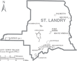
Municipalities and communities
Towns
|
Melville, Louisiana Melville is a town in St. Landry Parish, Louisiana, United States. The population was 1,376 at the 2000 census. It is part of the Opelousas–Eunice Micropolitan Statistical Area.-Geography:Melville is located at .... Palmetto, Louisiana Palmetto is a village in St. Landry Parish, Louisiana, United States. The population was 188 at the 2000 census. It is part of the Opelousas–Eunice Micropolitan Statistical Area.-Geography:Palmetto is located at .... Port Barre, Louisiana Port Barre is a town in St. Landry Parish, Louisiana, United States. The population was 2,287 at the 2000 census. It is part of the Opelousas–Eunice Micropolitan Statistical Area... Sunset, Louisiana Sunset is a town in St. Landry Parish, Louisiana, United States. The population was 2,897 at the 2010 census. It is part of the Opelousas–Eunice Micropolitan Statistical Area.-Geography:Sunset is located at .... Washington, Louisiana Washington is a small town in St. Landry Parish, Louisiana, United States. The population was 1,082 at the 2000 census. It is part of the Opelousas–Eunice Micropolitan Statistical Area.... |
See also
- National Register of Historic Places listings in St. Landry Parish, LouisianaNational Register of Historic Places listings in St. Landry Parish, LouisianaThis is a list of the National Register of Historic Places listings in St. Landry Parish, Louisiana.This is intended to be a complete list of the properties and districts on the National Register of Historic Places in St. Landry Parish, Louisiana, United States...
Resources
- Jack Claude Nezat The Nezat And Allied Families 1630-2007 Lulu 2007 ISBN 978-2-9528339-2-9, ISBN 978-0-615-15001-7
The author is one of the descendants of "Alexandre of Attakapas", Nezat Alexandre, born 1781 in Attakapas Post and died 1824
(Source Hebert).
External links
Geology
- Heinrich, P. V., and W. J. Autin, 2000, Baton Rouge 30 x 60 minute geologic quadrangle. Louisiana Geological Survey, Baton Rouge, Louisiana.
- Heinrich, P. V., J. Snead, and R. P. McCulloh, 2003, Crowley 30 x 60 minute geologic quadrangle. Louisiana Geological Survey, Baton Rouge, Louisiana.
- Snead, J., P. V. Heinrich, and R. P. McCulloh, 2002, Ville Platte 30 x 60 minute geologic quadrangle. Louisiana Geological Survey, Baton Rouge, Louisiana.