

St. Tammany Parish, Louisiana
Encyclopedia
St. Tammany Parish is a parish located in the U.S. state
of Louisiana
, in the New Orleans
–Metairie
–Kenner
Metropolitan Statistical Area
. The parish seat is Covington
.
In 2000, the population was 191,268. In 2004, the population was estimated to have grown to 212,000, and after the landfall of Hurricane Katrina
the following year, the population was estimated by St. Tammany Planners to be about 264,000. Most new residents are thought to have come from St. Bernard Parish. If correct, these figures make St. Tammany Parish the fastest-growing parish in the state, overtaking Livingston
and Ascension
.
St. Tammany Parish is colloquially referred to as part of the "Northshore" or "North Shore" throughout metropolitan New Orleans, owing to its location on Lake Ponchartrain. It is the most affluent parish in the metro area, has a system of public schools
, and is the most politically conservative parish in the New Orleans region.
The Moon Handbooks New Orleans: Including Cajun Country and the River Road, published in 2007, stated that people wanting to live in proximity to New Orleans without living in New Orleans will probably cause the population of St. Tammany Parish to increase.
, a French explorer, was the first European to visit the area of present-day St. Tammany Parish. While exploring lakes Pontchartrain
and Maurepas
, Iberville wrote in his journal, "The place where I am is one of the prettiest I have seen, fine level ground bare of canes. The land north of the lakes is a country of pine trees mixed with hard woods. The soil is sandy and many tracks of buffalo and deer can be seen."
St. Tammany was originally inhabited by numerous Indian peoples, including the Colapissas, Bayou Goulas, Chickasaw, Biloxi, Choctaw and Pensacola nations (although, Frederick S. Ellis, in his book St. Tammany Parish: L’autre Côté du Lac, claims that the regionally prominent Choctaw tribe did not arrive in the area until after it had begun to be settled by Europeans).
After the French were defeated in the French and Indian War
, St. Tammany (like the surrounding regions of the Florida Parishes
) became part of English West Florida
. Then, after Britain was defeated in the American Revolutionary War
, West Florida was governed by the British and the Spanish. During the West Florida period, St. Tammany, like the rest of West Florida, attracted British loyalists who wanted to escape persecution in the 13 colonies. The West Florida period ended with the West Florida Revolt, which preceded West Florida's annexation by the United States.
to claim the territory. Claiborne established the boundaries of the Florida Parishes
. He created St. Tammany Parish and named it after the Delaware Indian
Chief Tamanend
(c.1628-1698), who made peace with William Penn
and was generally renowned for his goodness. Among the nine Louisiana parishes (counties) named for "saints" (see "List of parishes of Louisiana"), St. Tammany is the only one whose eponym
is not a saint
as recognized by the Roman Catholic Church, the ecclesiastical parishes of which formed the basis for civil parishes prior to statehood. In fact, Tamanend is not known to have been a Christian, and was certainly not a Roman Catholic. However, he became popularly revered as an "American patron saint" in the post-Revolutionary
period (long after his death).
, a retreat with summer homes and hotels; and Madisonville
, a shipbuilding and sawmill town. The area south of Covington to Lake Ponchartrain's northern shore and extending eastwards to the Pearl River border with the state of Mississippi
was known as the Covington Lowlands. This region included the present-day towns of Mandeville, Abita Springs, Lacombe, Slidell, and Pearl River. Mandeville
was founded in 1834 and was developed as a health resort for wealthy New Orleanians, because it was believed that Ozone
was both salutary and naturally emitted by the numerous trees in the area (both beliefs later proven false), giving rise to an early name for the region — the "Ozone Belt". Regular ferry service commenced across Lake Pontchartrain
, and shortly thereafter another resort community was founded, Abita Springs
. A railroad was constructed in the 1880s connecting Covington and Abita Springs to Mandeville, and to New Orleans, allowing for further growth, particularly in Abita Springs, where underground spring waters permitted supposedly healthful baths.
, the I-10 Twin Span
), the parish began to develop as a bedroom community. Suburban sprawl
first took root in and around Slidell, Louisiana
, in the eastern part of the parish. Though the Causeway was completed in 1956 and linked suburban Metairie
with western St. Tammany, growth in and around western St. Tammany towns like Mandeville
, Covington
and Madisonville
only gathered momentum in the late 1960s. While St. Tammany was sparsely populated and almost wholly rural in the 1950s, its population exceeded 200,000 in the wake of Hurricane Katrina's
landfall in 2005.
A major event in the parish's transition from a bedroom community of commuters to a more diverse and independent economic unit occurred in 2008 with the relocation of Chevron's
regional corporate headquarters from downtown New Orleans
to an office park outside of Covington.
made its final landfall in eastern St. Tammany Parish. The western eye wall passed directly over St. Tammany Parish, Louisiana as a Category 3 hurricane at about 9:45 AM CST, August 29, 2005. The communities of Slidell, Louisiana, Avery Estates, Lakeshore Estates, Oak Harbor, Eden Isles and Northshore Beach were inundated by the storm surge that extended over six miles inland. The storm surge impacted all 57 miles of St. Tammany Parish’s coastline, including Lacombe, Mandeville
and Madisonville
. The storm surge in the area of the Rigolets Pass is estimated 16 feet, not including wave action declining to 7 feet at Madisonville
. The surge had a second peak in eastern St. Tammany as the westerly winds from the southern eye wall pushed the surge to the east, backing up at the bottleneck of the Rigolets Pass.
The Twin Spans of I-10 between Slidell and New Orleans East were virtually destroyed, and much of I-10 in New Orleans East was under water. The Lake Pontchartrain Causeway and the Highway 11 bridge, connecting the north and south shores of Lake Pontchartrain, were open only to emergency traffic.
Initial search and rescue operations were conducted south of Highway 190 from Lacombe east to the state line. Fire District No. 1 and the St. Tammany Parish Sheriff’s office evacuated over 3,000 people from flooded homes and rescued about 300 people in imminent danger. Radio communications among first responders functioned throughout the rescue period but the 9-1-1 system was not operational for ten days.
Utility services were not available anywhere in the parish. Generator power was available for hospitals and a special needs shelter. Hospitals were running at capacity on generator power.
The hurricane force winds toppled trees and telephone poles parish-wide, blocking all transportation routes. Land debris clean up continued into 2007 with over 6.6 million cubic yards collected. Debris cleaning in waterways continued at least through 2009.
Hurricane Katrina damaged 48,792 housing units in St. Tammany Parish from flood waters, high winds, or both.
, there were 191,268 people, 69,253 households and 52,701 families residing in the parish. The population density
was 224 per square mile (86/km²). There were 75,398 housing units at an average density of 88 per square mile (34/km²). The racial makeup of the parish was 87.03% White
, 9.90% Black
or African American
, 0.43% Native American
, 0.74% Asian
, 0.03% Pacific Islander
, 0.61% from other races
, and 1.26% from two or more races. 2.48% of the population were Hispanic
or Latino
of any race. There were 69,253 households of which 39.30% had children under the age of 18 living with them, 61.40% were married couples
living together, 11.00% had a female householder with no husband present, and 23.90% were non-families. 19.70% of all households were made up of individuals and 6.70% had someone living alone who was 65 years of age or older. The average household size was 2.73 and the average family size was 3.15.
Age distribution was 28.40% under the age of 18, 7.30% from 18 to 24, 29.90% from 25 to 44, 24.30% from 45 to 64, and 10.00% who were 65 years of age or older. The median age was 36 years. For every 100 females there were 96.10 males. For every 100 females age 18 and over, there were 92.40 males. The median household income
was $47,883, and the median family income was $55,346. Males had a median income of $41,876 versus $25,996 for females. The per capita income
for the parish was $22,514. About 7.60% of families and 9.70% of the population were below the poverty line, including 11.80% of those under age 18 and 10.10% of those age 65 or over.
received 76% of the vote (83,078 votes). Democrat Barack Obama
received 23% (24,596) votes. In the 2008 U.S. Senate election, although Democrat Mary Landrieu
won the election, she lost St. Tammany Parish. Her challenger, Republican John Kennedy, won 61% of the vote (65,150 votes). Landrieu received 36% of the vote (39,429 votes). In 2004, Republican George W. Bush
won 75% (75,139 votes). Democrat John F. Kerry won 24% (24,662 votes). The reason behind McCain winning St. Tammany Parish by a larger percent than Bush is perhaps due to the post-Katrina relocation of numerous, typically Republican St. Bernard Parish residents to St. Tammany Parish (so-called "St. Tammanards").
.
U.S. state
A U.S. state is any one of the 50 federated states of the United States of America that share sovereignty with the federal government. Because of this shared sovereignty, an American is a citizen both of the federal entity and of his or her state of domicile. Four states use the official title of...
of Louisiana
Louisiana
Louisiana is a state located in the southern region of the United States of America. Its capital is Baton Rouge and largest city is New Orleans. Louisiana is the only state in the U.S. with political subdivisions termed parishes, which are local governments equivalent to counties...
, in the New Orleans
New Orleans, Louisiana
New Orleans is a major United States port and the largest city and metropolitan area in the state of Louisiana. The New Orleans metropolitan area has a population of 1,235,650 as of 2009, the 46th largest in the USA. The New Orleans – Metairie – Bogalusa combined statistical area has a population...
–Metairie
Metairie, Louisiana
Metairie is a census-designated place in Jefferson Parish, Louisiana, United States and is a major part of the New Orleans Metropolitan Area. Metairie is the largest community in Jefferson Parish. It is an unincorporated area that would be larger than most of the state's cities if it were...
–Kenner
Kenner, Louisiana
Kenner is a city in Jefferson Parish, Louisiana, United States, and a suburb of New Orleans. The population was 66,702 at the 2010 census....
Metropolitan Statistical Area
New Orleans metropolitan area
New Orleans–Metairie–Kenner, or the Greater New Orleans Region is a metropolitan area designated by the United States Census encompassing seven parishes in the state of Louisiana, centering on the city of New Orleans...
. The parish seat is Covington
Covington, Louisiana
Covington is a city in and the parish seat of St. Tammany Parish, Louisiana, United States. The population was 8,483 at the 2000 census. It is located at a fork of the Bogue Falaya and the Tchefuncte River....
.
In 2000, the population was 191,268. In 2004, the population was estimated to have grown to 212,000, and after the landfall of Hurricane Katrina
Hurricane Katrina
Hurricane Katrina of the 2005 Atlantic hurricane season was a powerful Atlantic hurricane. It is the costliest natural disaster, as well as one of the five deadliest hurricanes, in the history of the United States. Among recorded Atlantic hurricanes, it was the sixth strongest overall...
the following year, the population was estimated by St. Tammany Planners to be about 264,000. Most new residents are thought to have come from St. Bernard Parish. If correct, these figures make St. Tammany Parish the fastest-growing parish in the state, overtaking Livingston
Livingston Parish, Louisiana
Livingston Parish Is a parish located in the U.S. state of Louisiana. Its parish seat is Livingston. As of 2010, its population was 128,026....
and Ascension
Ascension Parish, Louisiana
Ascension Parish is a parish located in the U.S. state of Louisiana. It is the fastest growing parish in the state. Its population is 107,215 which is 39.9% greater than the 2000 census...
.
St. Tammany Parish is colloquially referred to as part of the "Northshore" or "North Shore" throughout metropolitan New Orleans, owing to its location on Lake Ponchartrain. It is the most affluent parish in the metro area, has a system of public schools
St. Tammany Parish Public Schools
St. Tammany Parish Public Schools is a school district headquartered in Covington, Louisiana, United States.The district serves St. Tammany Parish.-High schools:* Covington High School * Fontainebleau High School...
, and is the most politically conservative parish in the New Orleans region.
The Moon Handbooks New Orleans: Including Cajun Country and the River Road, published in 2007, stated that people wanting to live in proximity to New Orleans without living in New Orleans will probably cause the population of St. Tammany Parish to increase.
Pre-history
In 1699, Pierre Le Moyne d'IbervillePierre Le Moyne d'Iberville
Pierre Le Moyne d'Iberville pronounced as described in note] Pierre Le Moyne d'Iberville pronounced as described in note] Pierre Le Moyne d'Iberville pronounced as described in note] (16 July 1661 – 9 July 1702 (probable)was a soldier, ship captain, explorer, colonial administrator, knight of...
, a French explorer, was the first European to visit the area of present-day St. Tammany Parish. While exploring lakes Pontchartrain
Lake Pontchartrain
Lake Pontchartrain is a brackish estuary located in southeastern Louisiana. It is the second-largest inland saltwater body of water in the United States, after the Great Salt Lake in Utah, and the largest lake in Louisiana. As an estuary, Pontchartrain is not a true lake.It covers an area of with...
and Maurepas
Lake Maurepas
Lake Maurepas is located in southeastern Louisiana approximately halfway between New Orleans and Baton Rouge directly west of Lake Pontchartrain.-Namesake:...
, Iberville wrote in his journal, "The place where I am is one of the prettiest I have seen, fine level ground bare of canes. The land north of the lakes is a country of pine trees mixed with hard woods. The soil is sandy and many tracks of buffalo and deer can be seen."
St. Tammany was originally inhabited by numerous Indian peoples, including the Colapissas, Bayou Goulas, Chickasaw, Biloxi, Choctaw and Pensacola nations (although, Frederick S. Ellis, in his book St. Tammany Parish: L’autre Côté du Lac, claims that the regionally prominent Choctaw tribe did not arrive in the area until after it had begun to be settled by Europeans).
West Florida
After the founding and development of New Orleans, French settlers began to enter the region. The primary industry was the production of pitch, tar, turpentine and resin from the forests.After the French were defeated in the French and Indian War
French and Indian War
The French and Indian War is the common American name for the war between Great Britain and France in North America from 1754 to 1763. In 1756, the war erupted into the world-wide conflict known as the Seven Years' War and thus came to be regarded as the North American theater of that war...
, St. Tammany (like the surrounding regions of the Florida Parishes
Florida Parishes
The Florida Parishes , also known as the North Shore region, are eight parishes in the southeastern part of the U.S. state of Louisiana, which were part of West Florida in the 18th and early 19th centuries. Unlike much of Louisiana, this region was not part of the Louisiana Purchase, as it had been...
) became part of English West Florida
West Florida
West Florida was a region on the north shore of the Gulf of Mexico, which underwent several boundary and sovereignty changes during its history. West Florida was first established in 1763 by the British government; as its name suggests it largely consisted of the western portion of the region...
. Then, after Britain was defeated in the American Revolutionary War
American Revolutionary War
The American Revolutionary War , the American War of Independence, or simply the Revolutionary War, began as a war between the Kingdom of Great Britain and thirteen British colonies in North America, and ended in a global war between several European great powers.The war was the result of the...
, West Florida was governed by the British and the Spanish. During the West Florida period, St. Tammany, like the rest of West Florida, attracted British loyalists who wanted to escape persecution in the 13 colonies. The West Florida period ended with the West Florida Revolt, which preceded West Florida's annexation by the United States.
Creation and naming of the parish
In 1810, President James Madison claimed West Florida as part of Louisiana and sent William C.C. ClaiborneWilliam C.C. Claiborne
William Charles Cole Claiborne was a United States politician, best known as the first Governor of Louisiana. He also has the distinction of possibly being the youngest Congressman in U.S...
to claim the territory. Claiborne established the boundaries of the Florida Parishes
Florida Parishes
The Florida Parishes , also known as the North Shore region, are eight parishes in the southeastern part of the U.S. state of Louisiana, which were part of West Florida in the 18th and early 19th centuries. Unlike much of Louisiana, this region was not part of the Louisiana Purchase, as it had been...
. He created St. Tammany Parish and named it after the Delaware Indian
Lenape
The Lenape are an Algonquian group of Native Americans of the Northeastern Woodlands. They are also called Delaware Indians. As a result of the American Revolutionary War and later Indian removals from the eastern United States, today the main groups live in Canada, where they are enrolled in the...
Chief Tamanend
Tamanend
Tamanend or Tammany or Tammamend, the "affable", was a chief of one of the clans that made up the Lenni-Lenape nation in the Delaware Valley at the time Philadelphia was established...
(c.1628-1698), who made peace with William Penn
William Penn
William Penn was an English real estate entrepreneur, philosopher, and founder of the Province of Pennsylvania, the English North American colony and the future Commonwealth of Pennsylvania. He was an early champion of democracy and religious freedom, notable for his good relations and successful...
and was generally renowned for his goodness. Among the nine Louisiana parishes (counties) named for "saints" (see "List of parishes of Louisiana"), St. Tammany is the only one whose eponym
Eponym
An eponym is the name of a person or thing, whether real or fictitious, after which a particular place, tribe, era, discovery, or other item is named or thought to be named...
is not a saint
Canonization
Canonization is the act by which a Christian church declares a deceased person to be a saint, upon which declaration the person is included in the canon, or list, of recognized saints. Originally, individuals were recognized as saints without any formal process...
as recognized by the Roman Catholic Church, the ecclesiastical parishes of which formed the basis for civil parishes prior to statehood. In fact, Tamanend is not known to have been a Christian, and was certainly not a Roman Catholic. However, he became popularly revered as an "American patron saint" in the post-Revolutionary
American Revolutionary War
The American Revolutionary War , the American War of Independence, or simply the Revolutionary War, began as a war between the Kingdom of Great Britain and thirteen British colonies in North America, and ended in a global war between several European great powers.The war was the result of the...
period (long after his death).
19th century
In the early 1830s, there were only two towns in St. Tammany: CovingtonCovington, Louisiana
Covington is a city in and the parish seat of St. Tammany Parish, Louisiana, United States. The population was 8,483 at the 2000 census. It is located at a fork of the Bogue Falaya and the Tchefuncte River....
, a retreat with summer homes and hotels; and Madisonville
Madisonville, Louisiana
Madisonville is a town in St. Tammany Parish, Louisiana, United States. The population was 677 at the 2000 census. It is part of the New Orleans–Metairie–Kenner Metropolitan Statistical Area.-Geography:...
, a shipbuilding and sawmill town. The area south of Covington to Lake Ponchartrain's northern shore and extending eastwards to the Pearl River border with the state of Mississippi
Mississippi
Mississippi is a U.S. state located in the Southern United States. Jackson is the state capital and largest city. The name of the state derives from the Mississippi River, which flows along its western boundary, whose name comes from the Ojibwe word misi-ziibi...
was known as the Covington Lowlands. This region included the present-day towns of Mandeville, Abita Springs, Lacombe, Slidell, and Pearl River. Mandeville
Mandeville, Louisiana
Mandeville is a city in St. Tammany Parish, Louisiana, United States. The population was 12,421 in 2008. Mandeville is located on the North Shore of Lake Pontchartrain, south of Interstate 12. It is across the lake from the city of New Orleans and its southshore suburbs...
was founded in 1834 and was developed as a health resort for wealthy New Orleanians, because it was believed that Ozone
Ozone
Ozone , or trioxygen, is a triatomic molecule, consisting of three oxygen atoms. It is an allotrope of oxygen that is much less stable than the diatomic allotrope...
was both salutary and naturally emitted by the numerous trees in the area (both beliefs later proven false), giving rise to an early name for the region — the "Ozone Belt". Regular ferry service commenced across Lake Pontchartrain
Lake Pontchartrain
Lake Pontchartrain is a brackish estuary located in southeastern Louisiana. It is the second-largest inland saltwater body of water in the United States, after the Great Salt Lake in Utah, and the largest lake in Louisiana. As an estuary, Pontchartrain is not a true lake.It covers an area of with...
, and shortly thereafter another resort community was founded, Abita Springs
Abita Springs, Louisiana
Abita Springs is a town in St. Tammany Parish, Louisiana, United States. The estimated population, in 2003, was 2,112. It is part of the New Orleans–Metairie–Kenner Metropolitan Statistical Area.-History:...
. A railroad was constructed in the 1880s connecting Covington and Abita Springs to Mandeville, and to New Orleans, allowing for further growth, particularly in Abita Springs, where underground spring waters permitted supposedly healthful baths.
20th century
With the completion of high-speed road connections to St. Tammany from New Orleans and its older suburbs (Lake Pontchartrain CausewayLake Pontchartrain Causeway
The Lake Pontchartrain Causeway, or the Causeway, consists of two parallel bridges crossing Lake Pontchartrain in southern Louisiana, United States. The longer of the two bridges is long...
, the I-10 Twin Span
Interstate 10
Interstate 10 is the fourth-longest Interstate Highway in the United States, after I-90, I-80, and I-40. It is the southernmost east–west, coast-to-coast Interstate Highway, although I-4 and I-8 are further south. It stretches from the Pacific Ocean at State Route 1 in Santa Monica,...
), the parish began to develop as a bedroom community. Suburban sprawl
Suburb
The word suburb mostly refers to a residential area, either existing as part of a city or as a separate residential community within commuting distance of a city . Some suburbs have a degree of administrative autonomy, and most have lower population density than inner city neighborhoods...
first took root in and around Slidell, Louisiana
Slidell, Louisiana
Slidell is a city situated on the northeast shore of Lake Pontchartrain in St. Tammany Parish, Louisiana, United States. The population was 25,695 at the 2000 census. The Greater Slidell Community has a population of about 90,000...
, in the eastern part of the parish. Though the Causeway was completed in 1956 and linked suburban Metairie
Metairie, Louisiana
Metairie is a census-designated place in Jefferson Parish, Louisiana, United States and is a major part of the New Orleans Metropolitan Area. Metairie is the largest community in Jefferson Parish. It is an unincorporated area that would be larger than most of the state's cities if it were...
with western St. Tammany, growth in and around western St. Tammany towns like Mandeville
Mandeville, Louisiana
Mandeville is a city in St. Tammany Parish, Louisiana, United States. The population was 12,421 in 2008. Mandeville is located on the North Shore of Lake Pontchartrain, south of Interstate 12. It is across the lake from the city of New Orleans and its southshore suburbs...
, Covington
Covington, Louisiana
Covington is a city in and the parish seat of St. Tammany Parish, Louisiana, United States. The population was 8,483 at the 2000 census. It is located at a fork of the Bogue Falaya and the Tchefuncte River....
and Madisonville
Madisonville, Louisiana
Madisonville is a town in St. Tammany Parish, Louisiana, United States. The population was 677 at the 2000 census. It is part of the New Orleans–Metairie–Kenner Metropolitan Statistical Area.-Geography:...
only gathered momentum in the late 1960s. While St. Tammany was sparsely populated and almost wholly rural in the 1950s, its population exceeded 200,000 in the wake of Hurricane Katrina's
Hurricane Katrina
Hurricane Katrina of the 2005 Atlantic hurricane season was a powerful Atlantic hurricane. It is the costliest natural disaster, as well as one of the five deadliest hurricanes, in the history of the United States. Among recorded Atlantic hurricanes, it was the sixth strongest overall...
landfall in 2005.
A major event in the parish's transition from a bedroom community of commuters to a more diverse and independent economic unit occurred in 2008 with the relocation of Chevron's
Chevron Corporation
Chevron Corporation is an American multinational energy corporation headquartered in San Ramon, California, United States and active in more than 180 countries. It is engaged in every aspect of the oil, gas, and geothermal energy industries, including exploration and production; refining,...
regional corporate headquarters from downtown New Orleans
New Orleans Central Business District
The Central Business District is a neighborhood of the city of New Orleans. A subdistrict of the French Quarter/CBD Area, its boundaries as defined by the City Planning Commission are: Iberville, Decatur and Canal Streets to the north, the Mississippi River to the east, the New Orleans Morial...
to an office park outside of Covington.
Hurricane Katrina 2005
Hurricane KatrinaHurricane Katrina
Hurricane Katrina of the 2005 Atlantic hurricane season was a powerful Atlantic hurricane. It is the costliest natural disaster, as well as one of the five deadliest hurricanes, in the history of the United States. Among recorded Atlantic hurricanes, it was the sixth strongest overall...
made its final landfall in eastern St. Tammany Parish. The western eye wall passed directly over St. Tammany Parish, Louisiana as a Category 3 hurricane at about 9:45 AM CST, August 29, 2005. The communities of Slidell, Louisiana, Avery Estates, Lakeshore Estates, Oak Harbor, Eden Isles and Northshore Beach were inundated by the storm surge that extended over six miles inland. The storm surge impacted all 57 miles of St. Tammany Parish’s coastline, including Lacombe, Mandeville
Mandeville
-People:*Bernard Mandeville, philosopher*Geoffrey de Mandeville, 1st Earl of Essex*Geoffrey de Mandeville, 2nd Earl of Essex*Sir John Mandeville, French language author*William de Mandeville, 3rd Earl of Essex-Places:*Mandeville, Eure, Normandy, France...
and Madisonville
Madisonville
Places named Madisonville in the United States include:* Madisonville, Kentucky* Madisonville, Louisiana* Madisonville, Cincinnati, Ohio* Madisonville, Tennessee* Madisonville, Texas...
. The storm surge in the area of the Rigolets Pass is estimated 16 feet, not including wave action declining to 7 feet at Madisonville
Madisonville
Places named Madisonville in the United States include:* Madisonville, Kentucky* Madisonville, Louisiana* Madisonville, Cincinnati, Ohio* Madisonville, Tennessee* Madisonville, Texas...
. The surge had a second peak in eastern St. Tammany as the westerly winds from the southern eye wall pushed the surge to the east, backing up at the bottleneck of the Rigolets Pass.
The Twin Spans of I-10 between Slidell and New Orleans East were virtually destroyed, and much of I-10 in New Orleans East was under water. The Lake Pontchartrain Causeway and the Highway 11 bridge, connecting the north and south shores of Lake Pontchartrain, were open only to emergency traffic.
Initial search and rescue operations were conducted south of Highway 190 from Lacombe east to the state line. Fire District No. 1 and the St. Tammany Parish Sheriff’s office evacuated over 3,000 people from flooded homes and rescued about 300 people in imminent danger. Radio communications among first responders functioned throughout the rescue period but the 9-1-1 system was not operational for ten days.
Utility services were not available anywhere in the parish. Generator power was available for hospitals and a special needs shelter. Hospitals were running at capacity on generator power.
The hurricane force winds toppled trees and telephone poles parish-wide, blocking all transportation routes. Land debris clean up continued into 2007 with over 6.6 million cubic yards collected. Debris cleaning in waterways continued at least through 2009.
Hurricane Katrina damaged 48,792 housing units in St. Tammany Parish from flood waters, high winds, or both.
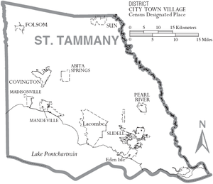
Geography
The parish has a total area of 1124 square miles (2,911.1 km²), of which 854 square miles (2,211.8 km²) is land and 270 square miles (699.3 km²) (24.01%) is water.Major highways
|
 Louisiana Highway 21 Louisiana Highway 21Louisiana Highway 21 Louisiana Highway 21 is a state highway in Louisiana that serves St. Tammany and Washington Parishes. It spans and is bannered north/south.-Route description:...  Louisiana Highway 22 Louisiana Highway 22Louisiana Highway 22 Louisiana Highway 22 is a state highway in Louisiana that serves St. Tammany, Tangipahoa, Livingston, and Ascension Parishes. It spans in a rough east/west direction and is bannered in each cardinal direction ....  Louisiana Highway 25 Louisiana Highway 25Louisiana Highway 25 Louisiana Highway 25 is a state highway in Louisiana, USA, that serves Saint Tammany and Washington Parishes. It spans and is bannered north/south.-Route description:...  Louisiana Highway 36 Louisiana Highway 36Louisiana Highway 36 Louisiana Highway 36 is a state highway in Louisiana that serves St. Tammany Parish. It spans and is bannered east/west.-Route description:...  Louisiana Highway 40 Louisiana Highway 40 Louisiana Highway 41 Louisiana Highway 41 |
 Interstate 10

 U.S. Highway 11
 U.S. Highway 90
 U.S. Highway 190
Adjacent parishes and natural features
- Washington ParishWashington Parish, LouisianaWashington Parish is a parish located in the U.S. state of Louisiana. Its parish seat is Franklinton. In 2000, its population was 43,926....
(north) - Pearl River CountyPearl River County, Mississippi-National protected areas:*Bogue Chitto National Wildlife Refuge *De Soto National Forest -Demographics:The census estimates of 2006 place the county population over 57,000 and place it among the 10 fastest growing counties in the U.S. As of the census of 2000, there were 48,621 people, 18,078...
, MississippiMississippiMississippi is a U.S. state located in the Southern United States. Jackson is the state capital and largest city. The name of the state derives from the Mississippi River, which flows along its western boundary, whose name comes from the Ojibwe word misi-ziibi...
(northeast) - Hancock CountyHancock County, Mississippi-Demographics:As of the census of 2000, there were 42,967 people, 16,897 households, and 11,827 families residing in the county. The population density was 90 people per square mile . There were 21,072 housing units at an average density of 44 per square mile...
, MississippiMississippiMississippi is a U.S. state located in the Southern United States. Jackson is the state capital and largest city. The name of the state derives from the Mississippi River, which flows along its western boundary, whose name comes from the Ojibwe word misi-ziibi...
(east) - Orleans Parish (south and southeast 24.5 miles across the Lake Ponchartrain Causeway Bridge)
- Lake PontchartrainLake PontchartrainLake Pontchartrain is a brackish estuary located in southeastern Louisiana. It is the second-largest inland saltwater body of water in the United States, after the Great Salt Lake in Utah, and the largest lake in Louisiana. As an estuary, Pontchartrain is not a true lake.It covers an area of with...
(south) - Jefferson ParishJefferson Parish, LouisianaJefferson Parish is a parish in Louisiana, United States that includes most of the suburbs of New Orleans. The seat of parish government is Gretna....
(southwest) - Tangipahoa ParishTangipahoa Parish, LouisianaTangipahoa Parish is a parish located in the U.S. state of Louisiana, one of the Florida Parishes. The parish seat is Amite City, but the major city is Hammond. As of 2006, the population was 113,137...
(west)
National protected areas
- Big Branch Marsh National Wildlife RefugeBig Branch Marsh National Wildlife RefugeBig Branch Marsh National Wildlife Refuge was formed in 1994. It is composed of of pine flatwoods, oak rides and coastal marsh. This diverse habitat is an example of the natural coastline of Lake Pontchartrain surrounded by fast developing communities....
- Bogue Chitto National Wildlife RefugeBogue Chitto National Wildlife RefugeBogue Chitto National Wildlife Refuge is located northeast of New Orleans, Louisiana and encompasses of Pearl River Basin swampland.-History:...
(part)
State protected areas
Demographics
At the 2000 censusCensus
A census is the procedure of systematically acquiring and recording information about the members of a given population. It is a regularly occurring and official count of a particular population. The term is used mostly in connection with national population and housing censuses; other common...
, there were 191,268 people, 69,253 households and 52,701 families residing in the parish. The population density
Population density
Population density is a measurement of population per unit area or unit volume. It is frequently applied to living organisms, and particularly to humans...
was 224 per square mile (86/km²). There were 75,398 housing units at an average density of 88 per square mile (34/km²). The racial makeup of the parish was 87.03% White
Race (United States Census)
Race and ethnicity in the United States Census, as defined by the Federal Office of Management and Budget and the United States Census Bureau, are self-identification data items in which residents choose the race or races with which they most closely identify, and indicate whether or not they are...
, 9.90% Black
Race (United States Census)
Race and ethnicity in the United States Census, as defined by the Federal Office of Management and Budget and the United States Census Bureau, are self-identification data items in which residents choose the race or races with which they most closely identify, and indicate whether or not they are...
or African American
Race (United States Census)
Race and ethnicity in the United States Census, as defined by the Federal Office of Management and Budget and the United States Census Bureau, are self-identification data items in which residents choose the race or races with which they most closely identify, and indicate whether or not they are...
, 0.43% Native American
Race (United States Census)
Race and ethnicity in the United States Census, as defined by the Federal Office of Management and Budget and the United States Census Bureau, are self-identification data items in which residents choose the race or races with which they most closely identify, and indicate whether or not they are...
, 0.74% Asian
Race (United States Census)
Race and ethnicity in the United States Census, as defined by the Federal Office of Management and Budget and the United States Census Bureau, are self-identification data items in which residents choose the race or races with which they most closely identify, and indicate whether or not they are...
, 0.03% Pacific Islander
Race (United States Census)
Race and ethnicity in the United States Census, as defined by the Federal Office of Management and Budget and the United States Census Bureau, are self-identification data items in which residents choose the race or races with which they most closely identify, and indicate whether or not they are...
, 0.61% from other races
Race (United States Census)
Race and ethnicity in the United States Census, as defined by the Federal Office of Management and Budget and the United States Census Bureau, are self-identification data items in which residents choose the race or races with which they most closely identify, and indicate whether or not they are...
, and 1.26% from two or more races. 2.48% of the population were Hispanic
Race (United States Census)
Race and ethnicity in the United States Census, as defined by the Federal Office of Management and Budget and the United States Census Bureau, are self-identification data items in which residents choose the race or races with which they most closely identify, and indicate whether or not they are...
or Latino
Race (United States Census)
Race and ethnicity in the United States Census, as defined by the Federal Office of Management and Budget and the United States Census Bureau, are self-identification data items in which residents choose the race or races with which they most closely identify, and indicate whether or not they are...
of any race. There were 69,253 households of which 39.30% had children under the age of 18 living with them, 61.40% were married couples
Marriage
Marriage is a social union or legal contract between people that creates kinship. It is an institution in which interpersonal relationships, usually intimate and sexual, are acknowledged in a variety of ways, depending on the culture or subculture in which it is found...
living together, 11.00% had a female householder with no husband present, and 23.90% were non-families. 19.70% of all households were made up of individuals and 6.70% had someone living alone who was 65 years of age or older. The average household size was 2.73 and the average family size was 3.15.
Age distribution was 28.40% under the age of 18, 7.30% from 18 to 24, 29.90% from 25 to 44, 24.30% from 45 to 64, and 10.00% who were 65 years of age or older. The median age was 36 years. For every 100 females there were 96.10 males. For every 100 females age 18 and over, there were 92.40 males. The median household income
Median household income
The median household income is commonly used to generate data about geographic areas and divides households into two equal segments with the first half of households earning less than the median household income and the other half earning more...
was $47,883, and the median family income was $55,346. Males had a median income of $41,876 versus $25,996 for females. The per capita income
Per capita income
Per capita income or income per person is a measure of mean income within an economic aggregate, such as a country or city. It is calculated by taking a measure of all sources of income in the aggregate and dividing it by the total population...
for the parish was $22,514. About 7.60% of families and 9.70% of the population were below the poverty line, including 11.80% of those under age 18 and 10.10% of those age 65 or over.
2008 and 2004 election results
St. Tammany Parish has heavily favored Republican politicians in recent years, and 2008 was no exception. In that year's presidential election, John McCainJohn McCain
John Sidney McCain III is the senior United States Senator from Arizona. He was the Republican nominee for president in the 2008 United States election....
received 76% of the vote (83,078 votes). Democrat Barack Obama
Barack Obama
Barack Hussein Obama II is the 44th and current President of the United States. He is the first African American to hold the office. Obama previously served as a United States Senator from Illinois, from January 2005 until he resigned following his victory in the 2008 presidential election.Born in...
received 23% (24,596) votes. In the 2008 U.S. Senate election, although Democrat Mary Landrieu
Mary Landrieu
Mary Loretta Landrieu is the senior United States Senator from the State of Louisiana and a member of the Democratic Party.Born in Arlington, Virginia, Landrieu was raised in New Orleans, Louisiana...
won the election, she lost St. Tammany Parish. Her challenger, Republican John Kennedy, won 61% of the vote (65,150 votes). Landrieu received 36% of the vote (39,429 votes). In 2004, Republican George W. Bush
George W. Bush
George Walker Bush is an American politician who served as the 43rd President of the United States, from 2001 to 2009. Before that, he was the 46th Governor of Texas, having served from 1995 to 2000....
won 75% (75,139 votes). Democrat John F. Kerry won 24% (24,662 votes). The reason behind McCain winning St. Tammany Parish by a larger percent than Bush is perhaps due to the post-Katrina relocation of numerous, typically Republican St. Bernard Parish residents to St. Tammany Parish (so-called "St. Tammanards").
Municipalities
Cities
- CovingtonCovington, LouisianaCovington is a city in and the parish seat of St. Tammany Parish, Louisiana, United States. The population was 8,483 at the 2000 census. It is located at a fork of the Bogue Falaya and the Tchefuncte River....
- MandevilleMandeville, LouisianaMandeville is a city in St. Tammany Parish, Louisiana, United States. The population was 12,421 in 2008. Mandeville is located on the North Shore of Lake Pontchartrain, south of Interstate 12. It is across the lake from the city of New Orleans and its southshore suburbs...
- SlidellSlidell, LouisianaSlidell is a city situated on the northeast shore of Lake Pontchartrain in St. Tammany Parish, Louisiana, United States. The population was 25,695 at the 2000 census. The Greater Slidell Community has a population of about 90,000...
Towns
- Abita SpringsAbita Springs, LouisianaAbita Springs is a town in St. Tammany Parish, Louisiana, United States. The estimated population, in 2003, was 2,112. It is part of the New Orleans–Metairie–Kenner Metropolitan Statistical Area.-History:...
- MadisonvilleMadisonville, LouisianaMadisonville is a town in St. Tammany Parish, Louisiana, United States. The population was 677 at the 2000 census. It is part of the New Orleans–Metairie–Kenner Metropolitan Statistical Area.-Geography:...
- Pearl RiverPearl River, LouisianaPearl River is a town in St. Tammany Parish, Louisiana, United States. The population was 1,839 at the 2000 census. It is part of the New Orleans–Metairie–Kenner Metropolitan Statistical Area.-Geography:...
Unincorporated places
- Alton
- Amos
- Audubon
- Barker's Corner
- Big Branch
- Blond
- Bonfouca
- BushBush, LouisianaBush is an unincorporated community in northeastern St. Tammany Parish, Louisiana, United States, to the south of Sun. Bush is on Louisiana Highway 21 between Covington and Bogalusa at 30,61° N, 89,90° W. It is part of the New Orleans–Metairie–Kenner Metropolitan Statistical...
- Chinchuba
- Crawford Landing
- Dave
- Davis Landing
- Florenville
- GoodbeeGoodbee, LouisianaGoodbee is an unincorporated community in Saint Tammany Parish, Louisiana, United States, at the intersection of U.S. Route 190 and Louisiana Highway 1077 west of Covington. Goodbee has a signed exit on Interstate 12 to its south, at its interchange with LA 1077.Northwest of Goodbee is the start...
- Haaswood
- Houltonville
- Hickory
- Lewisburg
- Maude
- McClane City
- Morgan Bluff
- North Slidell
- Oaklawn
- St. Benedict
- St. Joe
- St. Tammany
- St. Tammany Corner
- Talisheek
- Waldheim
- White Kitchen
Education
St. Tammany Parish Schools operates the public schools in the parish. The parish is the eponym of Saint Tammany Hall on the campus of Southeastern Louisiana UniversitySoutheastern Louisiana University
Southeastern Louisiana University is a state-funded public university in Hammond, Louisiana, United States. It was founded in 1925 by Linus A. Sims, the principal of Hammond High School, as Hammond Junior College, located in a wing of the high school building. Sims succeeded in getting the campus...
.
External links
- St. Tammany Parish government's website
- St. Tammany school board's website
- Explore the History and Culture of Southeastern Louisiana, a National Park Service Discover Our Shared Heritage Travel Itinerary
Geology
- Heinrich, P. V., R. P. McCulloh, and J. Snead, 2007, Bogalusa 30 x 60 minute geologic quadrangle. Louisiana Geological Survey, Baton Rouge, Louisiana.
- Heinrich, P. V., R. P. McCulloh, and J. Snead, 2004, Gulfport 30 x 60 minute geologic quadrangle. Louisiana Geological Survey, Baton Rouge, Louisiana.
- McCulloh, R. P., P. V. Heinrich, and J. Snead, 2003, Ponchatoula 30 x 60 minute geologic quadrangle. Louisiana Geological Survey, Baton Rouge, Louisiana.