

List of National Natural Landmarks in California
Encyclopedia
From List of National Natural Landmarks, these are the National Natural Landmark
s in California
. There are 35 in total.
National Natural Landmark
The National Natural Landmark program recognizes and encourages the conservation of outstanding examples of the natural history of the United States. It is the only natural areas program of national scope that identifies and recognizes the best examples of biological and geological features in...
s in California
California
California is a state located on the West Coast of the United States. It is by far the most populous U.S. state, and the third-largest by land area...
. There are 35 in total.
| Name | Image | Date | Location | County | Description |
|---|---|---|---|---|---|
| Amboy Crater Amboy Crater Amboy Crater and Lava Field is an extinct North American cinder cone type of volcano that rises above a lava field in southern California. They are located in the Mojave Desert equidistant and about between Barstow to the west and Needles to the east, and southwest of historic U.S. Route 66, in... |
Amboy Amboy, California Amboy is an unincorporated town in San Bernardino County, in California's Mojave Desert, west of Needles and east of Ludlow on historic Route 66. It is roughly 60 miles northeast of Twentynine Palms.-Geography:... 34.543889°N 115.791111°W |
San Bernardino San Bernardino County, California San Bernardino County is a county in the U.S. state of California. As of the 2010 census, the population was 2,035,210, up from 1,709,434 as of the 2000 census... |
A 6,000-year-old volcanic cinder cone Cinder cone According to the , Cinder Cone is the proper name of 1 cinder cone in Canada and 7 cinder cones in the United States:In Canada: Cinder Cone In the United States:... , made up of pahoehoe. Its location just off historic U.S. Highway 66 U.S. Route 66 U.S. Route 66 was a highway within the U.S. Highway System. One of the original U.S. highways, Route 66 was established on November 11, 1926 -- with road signs erected the following year... has given many visitors the opportunity to climb a volcano. |
||
| Anza-Borrego Desert Anza-Borrego Desert State Park Anza-Borrego Desert State Park is a state park located within the Colorado Desert of Southern California. The park takes its name from 18th century, Spanish explorer Juan Bautista de Anza and borrego, the Spanish word for bighorn sheep... |
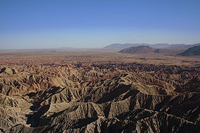 |
Imperial Imperial County, California Imperial County is a county located in the Imperial Valley, in the far southeast of the U.S. state of California, bordering both Arizona and Mexico. It is part of the El Centro Metropolitan Area, which encompasses all of Imperial County. The population as of 2000 was 142,361. The county seat is the... , Riverside Riverside County, California Riverside County is a county in the U.S. state of California. One of 58 California counties, it covers in the southern part of the state, and stretches from Orange County to the Colorado River, which forms the state border with Arizona. The county derives its name from the city of Riverside,... , San Diego San Diego County, California San Diego County is a large county located in the southwestern corner of the US state of California. Hence, San Diego County is also located in the southwestern corner of the 48 contiguous United States. Its county seat and largest city is San Diego. Its population was about 2,813,835 in the 2000... |
The largest desert state park in the nation. | ||
| Audubon Canyon Audubon Canyon Audubon Canyon is a coastal valley in Marin County, California, United States, which is associated with a small stream. The canyon provides habitat for a variety of animals and plants... |
Marin Marin County, California Marin County is a county located in the North San Francisco Bay Area of the U.S. state of California, across the Golden Gate Bridge from San Francisco. As of 2010, the population was 252,409. The county seat is San Rafael and the largest employer is the county government. Marin County is well... |
The largest known nesting area for great blue herons and American egrets on the Pacific Coast. | |||
| Año Nuevo State Reserve Año Nuevo State Reserve Año Nuevo State Park is a state park of California, USA, encompassing Año Nuevo Island and Año Nuevo Point, which are known for their pinniped rookeries. Located in San Mateo County, the low, rocky, windswept point juts out into the Pacific Ocean about south of San Francisco and the Golden Gate... |
 |
San Mateo San Mateo County, California San Mateo County is a county located in the San Francisco Bay Area of the U.S. state of California. It covers most of the San Francisco Peninsula just south of San Francisco, and north of Santa Clara County. San Francisco International Airport is located at the northern end of the county, and... |
The only mainland breeding ground for the northern elephant seal in the world. | ||
| American River American River The American River is a California watercourse noted as the site of Sutter's Mill, northwest of Placerville, California, where gold was found in 1848, leading to the California Gold Rush... and Phoenix Park Vernal Pools |
Sacramento Sacramento County, California Sacramento County is a county in the U.S. state of California. Its county seat is Sacramento, which is also the state capital. As of 2010 the county had a population of 1,418,788.... |
Contains outstanding examples of vernal pools, and blue oak woodlands | |||
| Black Chasm Cave Black Chasm Cave Black Chasm Cave is a cave near Volcano, California and is a National Natural Landmark.Black Chasm Cave was designated as a National Natural Landmark by the National Park Service in 1976... |
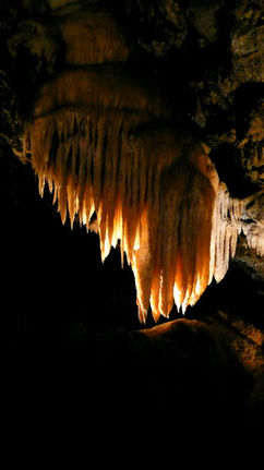 |
Amador | A small three-level cave containing an outstanding variety of speleothems and some of the best helictite formations in the West. | ||
| Burney Falls Burney Falls Burney Falls is a waterfall on Burney Creek, in McArthur-Burney Falls Memorial State Park, Shasta County, California.The water comes from underground springs above and at the falls, which are 129 feet high, and provides an almost constant flow rate of 100 million US gallons per day , even during... |
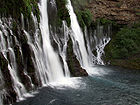 |
Shasta Shasta County, California Shasta County is a county located in the northern portion of the U.S. state of California. The county occupies the northern reaches of the Sacramento Valley, with portions extending into the southern reaches of the Cascade Range. As of the 2010 census, the population was 177,223, up from 163,256... |
Contains some of the best examples in the western United States of a river drainage regulated by stratigraphically-controlled springs, and of a waterfall formed by undercutting of horizontal rock layers. | ||
| Cinder Cone Natural Area Cinder Cone and the Fantastic Lava Beds Cinder Cone is a cinder cone volcano in Lassen Volcanic National Park . Within the park it is located about northeast of Lassen Peak and provides an excellent view of Brokeoff Mountain, Lassen Peak, and Chaos Crags.The cone was built to a height of above the surrounding area and spread ash over... |
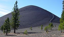 |
Lassen Volcanic National Park Lassen Volcanic National Park Lassen Volcanic National Park is a United States National Park in northeastern California. The dominant feature of the park is Lassen Peak; the largest plug dome volcano in the world and the southern-most volcano in the Cascade Range... |
A complex of over 20 large cinder cones of recent origin with extensive and continuous lava flows. | ||
| Cosumnes River Preserve Cosumnes River Preserve The Cosumnes River Preserve is a nature preserve of located 20 miles south of Sacramento, in the US state of California. The preserve protects a Central Valley remnant that once contained one of the largest expanses of oak tree savanna, riparian oak forest and wetland habitat in North America... |
Sacramento Sacramento County, California Sacramento County is a county in the U.S. state of California. Its county seat is Sacramento, which is also the state capital. As of 2010 the county had a population of 1,418,788.... |
A small remnant of a rapidly disappearing riparian woodland community type that once formed a major part of the central California valley. | |||
| Deep Springs Marsh | Inyo Inyo County, California -National protected areas:* Death Valley National Park * Inyo National Forest * Manzanar National Historic Site-Major highways:* U.S. Route 6* U.S. Route 395* State Route 127* State Route 136* State Route 168* State Route 178... |
An example of increasingly rare desert marsh. | |||
| Dixon Vernal Pools | Solano Solano County, California Solano County is a county located in Bay-Delta region of the U.S. state of California, about halfway between San Francisco and Sacramento and is one of the nine San Francisco Bay Area counties. The county's population was reported by the U.S. Census to be 413,344 in 2010... |
The best example of valley needlegrass grassland in the Great Central valley. | |||
| Elder Creek | Mendocino Mendocino County, California Mendocino County is a county located on the north coast of the U.S. state of California, north of the greater San Francisco Bay Area and west of the Central Valley. As of the 2010 census, the population was 87,841, up from 86,265 at the 2000 census... |
A largely undisturbed watershed containing large old stands of douglas fir, broadleaf evergreens, and deciduous trees. | |||
| Emerald Bay Emerald Bay State Park Emerald Bay State Park is a state park located around Emerald Bay, a National Natural Landmark since 1968, at Lake Tahoe, California. The park is home to Eagle Falls and Vikingsholm, a 38-room mansion that is one of the finest examples of Scandinavian architecture in the United States. The park... |
El Dorado El Dorado County, California El Dorado County is a county located in the historic Gold Country in the Sierra Nevada Mountains and foothills of the U.S. state of California. The 2010 population was 181,058. The El Dorado county seat is in Placerville.... |
An outstanding example of glacial geology. | |||
| Eureka Dunes | Inyo Inyo County, California -National protected areas:* Death Valley National Park * Inyo National Forest * Manzanar National Historic Site-Major highways:* U.S. Route 6* U.S. Route 395* State Route 127* State Route 136* State Route 168* State Route 178... |
The tallest dune complex in the Great Basin. | |||
| Fish Slough | Inyo Inyo County, California -National protected areas:* Death Valley National Park * Inyo National Forest * Manzanar National Historic Site-Major highways:* U.S. Route 6* U.S. Route 395* State Route 127* State Route 136* State Route 168* State Route 178... , Mono Mono County, California Mono County is a county located in the east central portion of the U.S. state of California, to the east of the Sierra Nevada between Yosemite National Park and Nevada. As of the 2010 census, the population was 14,202, up from 12,853 at the 2000 census... |
A large, essentially undisturbed desert wetland that provides habitat for the endangered Owens pupfish Owens pupfish The Owens pupfish is a rare species of fish in the family Cyprinodontidae, the pupfish. It is endemic to California in the United States, where it is limited to the Owens Valley. It is a federally listed endangered species of the United States. This pupfish is up to long, the largest males... . |
|||
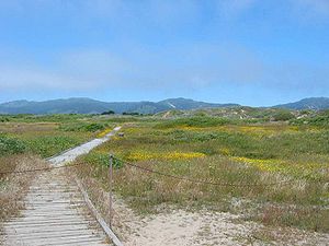
| Guadalupe-Nipomo Dunes Guadalupe-Nipomo Dunes Guadalupe-Nipomo Dunes is the largest remaining dune system south of San Francisco and the second largest in the U.S. state of California. It encompasses an stretch of coastline on the Central Coast of California and extends from southern San Luis Obispo County to northern Santa Barbara County.The... |
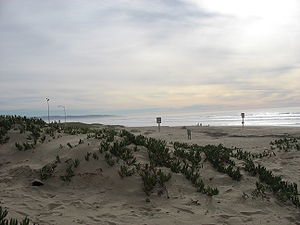 |
San Luis Obispo San Luis Obispo County, California San Luis Obispo County is a county located along the Pacific Ocean in the Central Coast of the U.S. state of California, between Los Angeles and the San Francisco Bay Area. As of the 2010 census its population was 269,637, up from 246,681 at the 2000 census... |
Contains the largest, relatively undisturbed coastal dune tract in California. | ||
| Imperial Sand Hills | Imperial Imperial County, California Imperial County is a county located in the Imperial Valley, in the far southeast of the U.S. state of California, bordering both Arizona and Mexico. It is part of the El Centro Metropolitan Area, which encompasses all of Imperial County. The population as of 2000 was 142,361. The county seat is the... |
One of the largest dune patches in the United States. | |||
| Irvine Ranch | Orange Orange County, California Orange County is a county in the U.S. state of California. Its county seat is Santa Ana. As of the 2010 census, its population was 3,010,232, up from 2,846,293 at the 2000 census, making it the third most populous county in California, behind Los Angeles County and San Diego County... |
A remarkably complete stratigraphic succession ranging in age from late Cretaceous Cretaceous The Cretaceous , derived from the Latin "creta" , usually abbreviated K for its German translation Kreide , is a geologic period and system from circa to million years ago. In the geologic timescale, the Cretaceous follows the Jurassic period and is followed by the Paleogene period of the... to the present. |
|||
| Miramar Mounds | San Diego San Diego County, California San Diego County is a large county located in the southwestern corner of the US state of California. Hence, San Diego County is also located in the southwestern corner of the 48 contiguous United States. Its county seat and largest city is San Diego. Its population was about 2,813,835 in the 2000... |
Contains unique soil features called mima mounds Mima Mounds Mima mounds is a term used for low, flattened, circular to oval, domelike, natural mounds found in the northwestern United States, Idaho, Oregon, and Washington, that are composed of loose, unstratified, often gravelly sediment that is an overthickened A Horizon... , which are found in only three or four locations in the country. |
|||
| Mitchell Caverns Mitchell Caverns The Mitchell's Caverns, within the Mitchell Caverns Natural Preserve, are a trio of limestone caves, located on the east side of the Providence Mountains at an elevation of 4300 ft , within the Providence Mountains State Recreation Area... and its "Winding Stair" cave |
 |
San Bernardino San Bernardino County, California San Bernardino County is a county in the U.S. state of California. As of the 2010 census, the population was 2,035,210, up from 1,709,434 as of the 2000 census... |
The most important solution caverns known in the Mohave Desert. | ||
| Mt. Diablo State Park | Contra Costa Contra Costa County, California Contra Costa County is a primarily suburban county in the San Francisco Bay Area of the U.S. state of California. As of the 2010 census, it had a population of 1,049,025... |
Geologic strata of Jurassic Jurassic The Jurassic is a geologic period and system that extends from about Mya to Mya, that is, from the end of the Triassic to the beginning of the Cretaceous. The Jurassic constitutes the middle period of the Mesozoic era, also known as the age of reptiles. The start of the period is marked by... , Cretaceous Cretaceous The Cretaceous , derived from the Latin "creta" , usually abbreviated K for its German translation Kreide , is a geologic period and system from circa to million years ago. In the geologic timescale, the Cretaceous follows the Jurassic period and is followed by the Paleogene period of the... , and Tertiary Tertiary The Tertiary is a deprecated term for a geologic period 65 million to 2.6 million years ago. The Tertiary covered the time span between the superseded Secondary period and the Quaternary... age can be seen in an aggregate thickness of 42000 feet (12,801.6 m). |
|||
| Mount Shasta Mount Shasta Mount Shasta is located at the southern end of the Cascade Range in Siskiyou County, California and at is the second highest peak in the Cascades and the fifth highest in California... |
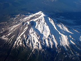 |
Siskiyou Siskiyou County, California Siskiyou County is a county located in the far northernmost part of the U.S. state of California, in the Shasta Cascade region on the Oregon border. Yreka is the county seat. Because of its substantial natural beauty, outdoor recreation opportunities, and Gold Rush era history, it is an important... |
One of the world's largest and most impressive stratovolcanoes. | ||
| Pixley Vernal Pools | Tulare Tulare County, California Tulare County is a county located in the Central Valley of the U.S. state of California, south of Fresno. Sequoia National Park is located in the county, as are part of Kings Canyon National Park, in its northeast corner , and part of Mount Whitney, on its eastern border... |
One of the few remaining natural vernal pools containing rare endemic plant species. | |||
| Point Lobos Point Lobos State Reserve Point Lobos is the common name for the area including Point Lobos State Natural Reserve and two adjoining marine protected areas: Point Lobos State Marine Reserve and Point Lobos State Marine Conservation Area... |
Monterey Monterey County, California Monterey County is a county located on the Pacific coast of the U.S. state of California, its northwestern section forming the southern half of Monterey Bay. The northern half of the bay is in Santa Cruz County. As of 2010, the population was 415,057. The county seat and largest city is Salinas... |
An outstanding example of terrestrial and marine environments in close association. | |||
| Pygmy Forest Pygmy forest A pygmy forest is a forest which, for pedological and geological reasons, contains only miniature trees. Pygmy forests may occur over various world locations with notable occurrences being noted in the literature of the: California coastal terraces and inner coastal mountains of Northern... at Van Damme State Park Van Damme State Park Van Damme State Park consists of about of land in Mendocino County, California, near the town of Little River on State Route 1. It was named for Charles Van Damme , who was born in the area and purchased the land that is now the park with profits from a San Francisco ferry business... |
Mendocino Mendocino County, California Mendocino County is a county located on the north coast of the U.S. state of California, north of the greater San Francisco Bay Area and west of the Central Valley. As of the 2010 census, the population was 87,841, up from 86,265 at the 2000 census... |
A unique forest of low, stunted trees and shrubs. | |||
| Rainbow Basin Rainbow Basin Rainbow Basin is a geological formation in the Calico Peaks range, located approximately eight miles north of Barstow in the Mojave Desert in San Bernardino County, California.... |
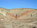 |
San Bernardino San Bernardino County, California San Bernardino County is a county in the U.S. state of California. As of the 2010 census, the population was 2,035,210, up from 1,709,434 as of the 2000 census... |
Deep erosion canyons with rugged rims. | ||
| Rancho La Brea Rancho La Brea Rancho La Brea was a Mexican land grant in present day Los Angeles County, California given in 1828 to Antonio Jose Rocha and Nemisio Dominguez by José Antonio Carrillo, the Alcalde of Los Angeles. Rancho La Brea consisted of one square league of land of what is now Wilshire's Miracle Mile, ... |
 |
Los Angeles Los Angeles County, California Los Angeles County is a county in the U.S. state of California. As of 2010 U.S. Census, the county had a population of 9,818,605, making it the most populous county in the United States. Los Angeles County alone is more populous than 42 individual U.S. states... |
Site of the world-famous natural asphalt tar pits. | ||
| San Andreas Fault San Andreas Fault The San Andreas Fault is a continental strike-slip fault that runs a length of roughly through California in the United States. The fault's motion is right-lateral strike-slip... |
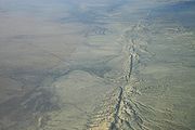 |
San Benito | One of the best illustrations of earth displacement caused by small crustal movements. | ||
| San Felipe Creek | Imperial Imperial County, California Imperial County is a county located in the Imperial Valley, in the far southeast of the U.S. state of California, bordering both Arizona and Mexico. It is part of the El Centro Metropolitan Area, which encompasses all of Imperial County. The population as of 2000 was 142,361. The county seat is the... |
Probably the last remaining perennial natural desert stream in the Colorado Desert region. | |||
| Sand Ridge Wildflower Preserve | Kern Kern County, California Spreading across the southern end of the California Central Valley, Kern County is the fifth-largest county by population in California. Its economy is heavily linked to agriculture and to petroleum extraction, and there is a strong aviation and space presence. Politically, it has generally... |
A remnant natural area displaying a great diversity of floral species. | |||
| Sharktooth Hill | Kern Kern County, California Spreading across the southern end of the California Central Valley, Kern County is the fifth-largest county by population in California. Its economy is heavily linked to agriculture and to petroleum extraction, and there is a strong aviation and space presence. Politically, it has generally... |
One of the most abundant, diverse and well- preserved fossil marine vertebrate sites in the world. | |||
| Tijuana River Estuary Tijuana River Estuary The Tijuana River Estuary is an intertidal coastal wetland in San Diego County, California, USA bordering Tijuana, Baja California. It is the location of the Tijuana River National Estuarine Research Reserve. The estuary is a shallow water habitat... |
San Diego San Diego County, California San Diego County is a large county located in the southwestern corner of the US state of California. Hence, San Diego County is also located in the southwestern corner of the 48 contiguous United States. Its county seat and largest city is San Diego. Its population was about 2,813,835 in the 2000... |
One of the finest remaining saltwater marshes on the California coastline. | |||
| Torrey Pines State Reserve Torrey Pines State Reserve Torrey Pines State Natural Reserve is a coastal state park located in the California community of La Jolla, San Diego, California, off North Torrey Pines Road . Although it is located within San Diego city limits, it remains one of the wildest stretches of land on the Southern California coast... |
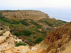 |
San Diego San Diego County, California San Diego County is a large county located in the southwestern corner of the US state of California. Hence, San Diego County is also located in the southwestern corner of the 48 contiguous United States. Its county seat and largest city is San Diego. Its population was about 2,813,835 in the 2000... |
Contains a unique and undisturbed biological community supporting endangered bird species. | ||
| Trona Pinnacles Trona Pinnacles Trona PinnaclesDesignationNational Natural LandmarkLocationCaliforniaNearest CityTrona, CaliforniaCoordinatesArea Date of Establishment1968Governing BodyBureau of Land Management... |
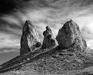 |
San Bernardino San Bernardino County, California San Bernardino County is a county in the U.S. state of California. As of the 2010 census, the population was 2,035,210, up from 1,709,434 as of the 2000 census... |
A relict landform from the Pleistocene containing unique formations of calcium carbonate. | ||
| Turtle Mountain Turtle Mountains (California) The Turtle Mountains, and Amat 'Achii'ar in the Mojave language, are located in San Bernardino County, California, in the southeastern part of the state.-Geography:The Turtle Mountains are southeast of Needles, California, west off of U.S... |
San Bernardino San Bernardino County, California San Bernardino County is a county in the U.S. state of California. As of the 2010 census, the population was 2,035,210, up from 1,709,434 as of the 2000 census... |
Contains two mountain sections of entirely different composition. | |||