
Amboy, California
Encyclopedia
Amboy is an unincorporated town in San Bernardino County
, in California
's Mojave Desert
, west of Needles
and east of Ludlow
on historic Route 66
. It is roughly 60 miles (97 km) northeast of Twentynine Palms
.
, Providence Mountains
, and the Mojave National Preserve
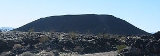
. Adjacent to the south is the landmark Amboy Crater
, and beyond to the southeast the Bullion Mountains
. To the south is Bristol Dry Lake
and Cadiz, California
.
Amboy was once a major stop along famous Route 66
but has seen much lower visitation since the opening of Interstate 40
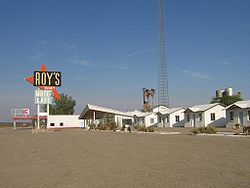
to the north in 1973. Amboy is home to the famous Roy's Motel and Cafe
, a Route 66 landmark.
The town has a total of 10 surviving buildings and a population of far fewer than the advertised 20. According to the Los Angeles Times
, the town's population is approximately 4 (though according to the August 2010 edition of the U.K. magazine "Car" this had risen to 8, all of whom are male). Amboy is located in ZIP code
92304 and area code 760
.
for the Atlantic and Pacific Railroad
, created the town as the first of a series of alphabetical railroad stations that were to be constructed across the Mojave Desert
.
In 1926, Amboy became a boom town after the opening of U.S. Route 66. In 1938, Roy's Motel and Cafe
opened, which prospered due to its isolated location on the route. By 1940, Amboy's population had increased to 65. Its growth was tied not only to tourists, but also to the Santa Fe Railroad
over which high-speed freight trains still run today between Kingman, Arizona
and the BNSF Railway
Barstow, California
yard.
During the Great Depression
and World War II
, tourism declined nationally. But the remaining travelers need for lodging, meals, and gasoline kept the town busy. The town remained this way until the opening of Interstate 40
in 1973, which bypassed Amboy.
Today, the only life remaining in Amboy are Roy's, which as of 2009 is a gift shop, and the chloride salt canals, which rank among the world's largest. The town is currently owned by Albert Okura, who plans to restore it to a tourist attraction again.
is a 6,000-year-old cinder cone
volcano, made largely of pahoehoe lava. Pisgah Crater
, also a cinder cone volcano, is located near Interstate 40
. Because of quarry operations, the crater is not as well preserved as Amboy Crater.
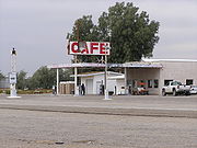 Roy's Motel and Cafe
was the only gasoline, food and lodging stop for miles around that part of the eastern Mojave and was well known for both its Googie "retro-future" architecture added to one of the original buildings and even more famous sign, a 1959 addition. Both Roy's and the surrounding town were once owned by Buster Burris, one of Route 66's most famous characters who purchased Roy's from his father-in-law Roy Crowl, the man for whom the property is named, in 1938 and ran the town until 1995.
In 1938 Roy Crowl opened "Roy's" as a service station on Route 66 in Amboy. Roy, together with his wife Velma, owned the town. In the 1940s Roy teamed up with Herman "Buster" Burris who married his daughter Betty. Together they expanded the business, keeping it open 24 hours a day and adding the motel to the service station and cafe. Business boomed in the deluge of motor tourists after World War II
.
The routing of the old National Trails Highway (1914) and its better-traveled successor, Route 66
through Amboy saw a steady growth of business, especially at Roy's. The complex was so busy during summer vacation that Burris placed classified ads in other states to bring in employees.
 Buster sold the town in 1995, and moved to Twentynine Palms
where he died in 2000. The town was owned by investors Walt Wilson and Tim White who mainly used for photo shots and to host movie companys. After the two lost it in foreclosure, it was repossessed by Bessie Burris, Buster's widow. Bessie sold the property in February 2005 to Albert Okura, owner of the Juan Pollo restaurant chain, who offered $425,000 in cash and promised to preserve the town and reopen Roy's.
On April 28, 2008, Roy's reopened. The renovations and repairs cost $100,000. Albert Okura also has plans to open a cafe and mini-mart at the same location.
Roy's has even attracted some well-known regulars. Actors Harrison Ford
and Anthony Hopkins
have autographed photos on the walls of the restaurant and visit whenever their schedules allow. Ford frequently flies in and lands his plane on a nearby landing strip, one of the first ever built in California.
was formerly used as a Shoe tree.
' music video "Hero" and the film Live Evil
. Owners Wilson and White maintained Amboy in weathered, unrestored condition for use as a motion picture film site.
Radiator Springs, the ghost town featured in Cars, was loosely based on Amboy.
San Bernardino County, California
San Bernardino County is a county in the U.S. state of California. As of the 2010 census, the population was 2,035,210, up from 1,709,434 as of the 2000 census...
, in California
California
California is a state located on the West Coast of the United States. It is by far the most populous U.S. state, and the third-largest by land area...
's Mojave Desert
Mojave Desert
The Mojave Desert occupies a significant portion of southeastern California and smaller parts of central California, southern Nevada, southwestern Utah and northwestern Arizona, in the United States...
, west of Needles
Needles, California
Needles is a city located in the Mojave Desert on the western banks of the Colorado River in San Bernardino County, California. It is located in the Mohave Valley, which straddles the California–Arizona border. The city is accessible via Interstate 40 and U.S. Route 95...
and east of Ludlow
Ludlow, California
Ludlow is a small town in the Mojave Desert on Interstate 40, located in San Bernardino County, California, United States. The older remains of the ghost town are along historic Route 66.-Geography:...
on historic Route 66
U.S. Route 66 in California
In the U.S. state of California, U.S. Route 66 is a former U.S. highway. All the portions were deleted by 1964 during the 1964 renumbering.-History:U.S...
. It is roughly 60 miles (97 km) northeast of Twentynine Palms
Twentynine Palms, California
Twentynine Palms is a city in San Bernardino County, California, United States. It was previously called Twenty-Nine Palms...
.
Geography
The town is south of the Granite MountainsGranite Mountains
Granite Mountains may refer to one of four mountain ranges in the United States:*Granite Mountains *Granite Mountains *Granite Mountains *Granite Mountains...
, Providence Mountains
Providence Mountains
The Providence Mountains are found in the eastern Mojave Desert of San Bernardino County, California, U.S. The range reaches an elevation of at Edgar Peak and is home to the Mitchell Caverns Natural Preserve in the Providence Mountains State Recreation Area, and the Mojave National...
, and the Mojave National Preserve
Mojave National Preserve
Mojave National Preserve is located in the Mojave Desert of San Bernardino County, California, USA, between Interstate 15 and Interstate 40. The preserve was established October 31, 1994 with the passage of the California Desert Protection Act by the US Congress...
. Adjacent to the south is the landmark Amboy Crater
Amboy Crater
Amboy Crater and Lava Field is an extinct North American cinder cone type of volcano that rises above a lava field in southern California. They are located in the Mojave Desert equidistant and about between Barstow to the west and Needles to the east, and southwest of historic U.S. Route 66, in...
, and beyond to the southeast the Bullion Mountains
Bullion Mountains
The Bullion Mountains are located in the Mojave Desert of California southeast of the city of Barstow. The mountain range stretches for approximately 50 miles in a northwest-southeasterly direction north of Joshua Tree and Twentynine Palms....
. To the south is Bristol Dry Lake
Bristol Dry Lake
Bristol Lake is a dry lake in the Mojave Desert of San Bernardino County, California, northeast of Twentynine Palms.Bristol Lake is located directly south of Amboy, California and U.S. Route 66, and is north of Cadiz, California...
and Cadiz, California
Cadiz, California
Cadiz is a small unincorporated community in the Mojave Desert in San Bernardino County, California. It is located just south of the Marble Mountains near the National Trails Highway. Cadiz is home to a former railroad stop, and is situated at 34° 31' 12" North latitude and 115° 30' 43" West...
.
Amboy was once a major stop along famous Route 66
U.S. Route 66 in California
In the U.S. state of California, U.S. Route 66 is a former U.S. highway. All the portions were deleted by 1964 during the 1964 renumbering.-History:U.S...
but has seen much lower visitation since the opening of Interstate 40
Interstate 40 in California
In the U.S. state of California, Interstate 40 has its western terminus in Barstow. Known as the Needles Freeway, a major east–west route of the Interstate Highway System, it heads east from Barstow across the Mojave Desert in San Bernardino County past the Clipper Mountains to Needles,...
to the north in 1973. Amboy is home to the famous Roy's Motel and Cafe
Roy's Motel and Cafe
Roy's Motel and Cafe is a defunct motel, cafe, gas station, auto repair shop on the National Trails Highway of U.S. Route 66 in the Mojave Desert town of Amboy in San Bernardino County, California...
, a Route 66 landmark.
The town has a total of 10 surviving buildings and a population of far fewer than the advertised 20. According to the Los Angeles Times
Los Angeles Times
The Los Angeles Times is a daily newspaper published in Los Angeles, California, since 1881. It was the second-largest metropolitan newspaper in circulation in the United States in 2008 and the fourth most widely distributed newspaper in the country....
, the town's population is approximately 4 (though according to the August 2010 edition of the U.K. magazine "Car" this had risen to 8, all of whom are male). Amboy is located in ZIP code
ZIP Code
ZIP codes are a system of postal codes used by the United States Postal Service since 1963. The term ZIP, an acronym for Zone Improvement Plan, is properly written in capital letters and was chosen to suggest that the mail travels more efficiently, and therefore more quickly, when senders use the...
92304 and area code 760
Area code 760
Image:Area_code_442.svg|right|Map of California area codes in blue with 442/760 in redrect 65 82 92 100 Area code 916rect 220 242 245 256 Area code 909rect 243 274 265 287 Area code 951rect 136 323 160 338 Area code 858...
.
History
Although Amboy was first settled in 1858, the town not established until 1883. Lewis Kingman, a locating engineerLocating engineer
A locating engineer is a civil engineer that surveys the best course for a road, or rail line, through the available terrain....
for the Atlantic and Pacific Railroad
Atlantic and Pacific Railroad
The Atlantic and Pacific Railroad was a U.S. railroad that owned or operated two disjoint segments, one connecting St. Louis, Missouri with Tulsa, Oklahoma, and the other connecting Albuquerque, New Mexico with Southern California. It was incorporated by the U.S. Congress in 1866 as a...
, created the town as the first of a series of alphabetical railroad stations that were to be constructed across the Mojave Desert
Mojave Desert
The Mojave Desert occupies a significant portion of southeastern California and smaller parts of central California, southern Nevada, southwestern Utah and northwestern Arizona, in the United States...
.
In 1926, Amboy became a boom town after the opening of U.S. Route 66. In 1938, Roy's Motel and Cafe
Roy's Motel and Cafe
Roy's Motel and Cafe is a defunct motel, cafe, gas station, auto repair shop on the National Trails Highway of U.S. Route 66 in the Mojave Desert town of Amboy in San Bernardino County, California...
opened, which prospered due to its isolated location on the route. By 1940, Amboy's population had increased to 65. Its growth was tied not only to tourists, but also to the Santa Fe Railroad
Atchison, Topeka and Santa Fe Railway
The Atchison, Topeka and Santa Fe Railway , often abbreviated as Santa Fe, was one of the larger railroads in the United States. The company was first chartered in February 1859...
over which high-speed freight trains still run today between Kingman, Arizona
Kingman, Arizona
Kingman is located in a desert climate on the edge of the Mojave Desert, but its higher elevation and location between the Colorado Plateau and the Lower Colorado River Valley tempers summer high temperatures and contributes to winter cold and rare snowfall. Summer daytime highs reach above 90 °F ...
and the BNSF Railway
BNSF Railway
The BNSF Railway is a wholly owned subsidiary of Berkshire Hathaway Inc., and is headquartered in Fort Worth, Texas. It is one of seven North American Class I railroads and the second largest freight railroad network in North America, second only to the Union Pacific Railroad, its primary...
Barstow, California
Barstow, California
Barstow is a city in San Bernardino County, California, United States. The population was 22,639 at the 2010 census, up from 21,119 at the 2000 census. Barstow is located north of San Bernardino....
yard.
During the Great Depression
Great Depression
The Great Depression was a severe worldwide economic depression in the decade preceding World War II. The timing of the Great Depression varied across nations, but in most countries it started in about 1929 and lasted until the late 1930s or early 1940s...
and World War II
World War II
World War II, or the Second World War , was a global conflict lasting from 1939 to 1945, involving most of the world's nations—including all of the great powers—eventually forming two opposing military alliances: the Allies and the Axis...
, tourism declined nationally. But the remaining travelers need for lodging, meals, and gasoline kept the town busy. The town remained this way until the opening of Interstate 40
Interstate 40
Interstate 40 is the third-longest major east–west Interstate Highway in the United States, after I-90 and I-80. Its western end is at Interstate 15 in Barstow, California; its eastern end is at a concurrency of U.S. Route 117 and North Carolina Highway 132 in Wilmington, North Carolina...
in 1973, which bypassed Amboy.
Today, the only life remaining in Amboy are Roy's, which as of 2009 is a gift shop, and the chloride salt canals, which rank among the world's largest. The town is currently owned by Albert Okura, who plans to restore it to a tourist attraction again.
Nearby craters
Two extinct volcanoes are located to the west of Amboy. Amboy CraterAmboy Crater
Amboy Crater and Lava Field is an extinct North American cinder cone type of volcano that rises above a lava field in southern California. They are located in the Mojave Desert equidistant and about between Barstow to the west and Needles to the east, and southwest of historic U.S. Route 66, in...
is a 6,000-year-old cinder cone
Cinder cone
According to the , Cinder Cone is the proper name of 1 cinder cone in Canada and 7 cinder cones in the United States:In Canada: Cinder Cone In the United States:...
volcano, made largely of pahoehoe lava. Pisgah Crater
Pisgah Crater
Pisgah Crater, or Pisgah Volcano, is a young volcanic cinder cone rising above a lava plain in the Mojave Desert, between Barstow and Needles, California in San Bernardino County, California. The volcanic peak is around south of historic U.S...
, also a cinder cone volcano, is located near Interstate 40
Interstate 40
Interstate 40 is the third-longest major east–west Interstate Highway in the United States, after I-90 and I-80. Its western end is at Interstate 15 in Barstow, California; its eastern end is at a concurrency of U.S. Route 117 and North Carolina Highway 132 in Wilmington, North Carolina...
. Because of quarry operations, the crater is not as well preserved as Amboy Crater.
Roy's Motel and Cafe
Roy's Motel and Cafe
Roy's Motel and Cafe is a defunct motel, cafe, gas station, auto repair shop on the National Trails Highway of U.S. Route 66 in the Mojave Desert town of Amboy in San Bernardino County, California...
was the only gasoline, food and lodging stop for miles around that part of the eastern Mojave and was well known for both its Googie "retro-future" architecture added to one of the original buildings and even more famous sign, a 1959 addition. Both Roy's and the surrounding town were once owned by Buster Burris, one of Route 66's most famous characters who purchased Roy's from his father-in-law Roy Crowl, the man for whom the property is named, in 1938 and ran the town until 1995.
In 1938 Roy Crowl opened "Roy's" as a service station on Route 66 in Amboy. Roy, together with his wife Velma, owned the town. In the 1940s Roy teamed up with Herman "Buster" Burris who married his daughter Betty. Together they expanded the business, keeping it open 24 hours a day and adding the motel to the service station and cafe. Business boomed in the deluge of motor tourists after World War II
World War II
World War II, or the Second World War , was a global conflict lasting from 1939 to 1945, involving most of the world's nations—including all of the great powers—eventually forming two opposing military alliances: the Allies and the Axis...
.
The routing of the old National Trails Highway (1914) and its better-traveled successor, Route 66
U.S. Route 66
U.S. Route 66 was a highway within the U.S. Highway System. One of the original U.S. highways, Route 66 was established on November 11, 1926 -- with road signs erected the following year...
through Amboy saw a steady growth of business, especially at Roy's. The complex was so busy during summer vacation that Burris placed classified ads in other states to bring in employees.
Twentynine Palms, California
Twentynine Palms is a city in San Bernardino County, California, United States. It was previously called Twenty-Nine Palms...
where he died in 2000. The town was owned by investors Walt Wilson and Tim White who mainly used for photo shots and to host movie companys. After the two lost it in foreclosure, it was repossessed by Bessie Burris, Buster's widow. Bessie sold the property in February 2005 to Albert Okura, owner of the Juan Pollo restaurant chain, who offered $425,000 in cash and promised to preserve the town and reopen Roy's.
On April 28, 2008, Roy's reopened. The renovations and repairs cost $100,000. Albert Okura also has plans to open a cafe and mini-mart at the same location.
Roy's has even attracted some well-known regulars. Actors Harrison Ford
Harrison Ford
Harrison Ford is an American film actor and producer. He is famous for his performances as Han Solo in the original Star Wars trilogy and as the title character of the Indiana Jones film series. Ford is also known for his roles as Rick Deckard in Blade Runner, John Book in Witness and Jack Ryan in...
and Anthony Hopkins
Anthony Hopkins
Sir Philip Anthony Hopkins, KBE , best known as Anthony Hopkins, is a Welsh actor of film, stage and television...
have autographed photos on the walls of the restaurant and visit whenever their schedules allow. Ford frequently flies in and lands his plane on a nearby landing strip, one of the first ever built in California.
Shoe Tree
A palo verde tree east of Roy's on Route 66U.S. Route 66
U.S. Route 66 was a highway within the U.S. Highway System. One of the original U.S. highways, Route 66 was established on November 11, 1926 -- with road signs erected the following year...
was formerly used as a Shoe tree.
Popular culture
Part of the 1986 motion picture The Hitcher with Rutger Hauer was filmed in Amboy while Roy's was the setting for a 1999 television commercial for Qwest Communications. It was also used in Enrique IglesiasEnrique Iglesias
Enrique Iglesias is a Spanish pop music singer, a son of singer Julio Iglesias.Enrique started his musical career on Mexican label Fonovisa...
' music video "Hero" and the film Live Evil
Live Evil (film)
Live Evil is a 2009 independent action horror film directed by Jay Woelfel, produced by Mark Terry and starring Tim Thomerson, Ken Foree, Mark Hengst and Tiffany Shepis.-Plot:...
. Owners Wilson and White maintained Amboy in weathered, unrestored condition for use as a motion picture film site.
Radiator Springs, the ghost town featured in Cars, was loosely based on Amboy.