

List of Colorado National Parks
Encyclopedia
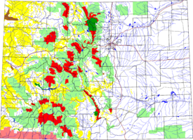
The following are protected federal lands
in the state of Colorado
:
 There are four National Parks
within the state of Colorado:
 The six National Monuments in the state of Colorado are:
 The two National Historic Sites within the state of Colorado are:
s that pass through the state of Colorado are:
that passes through the state of Colorado is:
 The 11 National Forests
within the state of Colorado are:
within the state of Colorado are:
 The 42 National Wilderness Areas
within the state of Colorado are:
 The eight National Wildlife Refuge
s within the state of Colorado are:
 The 28 federally designated National Recreation Trail
s in the state of Colorado are:
Federal lands
Federal lands are lands in the United States for which ownership is claimed by the U.S. federal government.-Primary federal land holders:*Bureau of Land Management*United States Forest Service*United States Fish and Wildlife Service*National Park Service...
in the state of Colorado
Colorado
Colorado is a U.S. state that encompasses much of the Rocky Mountains as well as the northeastern portion of the Colorado Plateau and the western edge of the Great Plains...
:
National Parks
National Park Service
The National Park Service is the U.S. federal agency that manages all national parks, many national monuments, and other conservation and historical properties with various title designations...
within the state of Colorado:
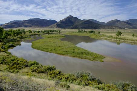
- Black Canyon of the Gunnison National ParkBlack Canyon of the Gunnison National Parkthumb|upright|Black Canyon of the GunnisonBlack Canyon of the Gunnison National Park is a United States National Park located in western Colorado, and managed by the National Park Service...
near MontroseMontrose, ColoradoThe City of Montrose is a Home Rule Municipality that is the county seat and the most populous city of Montrose County, Colorado, United States. The United States Census Bureau estimates that the city population was 15,479 in 2005. The main road that leads in and out of Montrose is U.S... - Great Sand Dunes National Park and PreserveGreat Sand Dunes National Park and Preserve-Other features:The park also contains alpine lakes and tundra, six peaks over 13,000 feet in elevation, ancient spruce and pine forests, large stands of aspen and cottonwood, grasslands, and wetlands — all habitat for diverse wildlife and plant species.One of the most unusual features of...
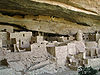
near MoscaMosca, ColoradoMosca is an unincorporated town and a U.S. Post Office in Alamosa County, Colorado, United States. It was named for the nearby Mosca Pass, which was named for the Spanish explorer, Luis de Moscoso de Alvarado... - Mesa Verde National ParkMesa Verde National ParkMesa Verde National Park is a U.S. National Park and UNESCO World Heritage Site located in Montezuma County, Colorado, United States. It was created in 1906 to protect some of the best-preserved cliff dwellings in the world...
and UNESCOUNESCOThe United Nations Educational, Scientific and Cultural Organization is a specialized agency of the United Nations...
World Heritage SiteWorld Heritage SiteA UNESCO World Heritage Site is a place that is listed by the UNESCO as of special cultural or physical significance...
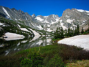
near CortezCortez, ColoradoThe city of Cortez is a Home Rule Municipality that is the county seat and the most populous city of Montezuma County, Colorado, United States. The city population was 8,482 at the 2010 census... - Rocky Mountain National ParkRocky Mountain National ParkRocky Mountain National Park is a national park located in the north-central region of the U.S. state of Colorado.It features majestic mountain views, a variety of wildlife, varied climates and environments—from wooded forests to mountain tundra—and easy access to back-country trails...
near Estes ParkEstes Park, ColoradoEstes Park is a town in Larimer County, Colorado, United States. A popular summer resort and the location of the headquarters for Rocky Mountain National Park, Estes Park lies along the Big Thompson River. Estes Park had a population of 5,858 at the 2010 census...
and Grand LakeGrand Lake, ColoradoThe Town of Grand Lake is a Statutory Town located in Grand County, Colorado, United States. The population was 447 at the 2000 census....
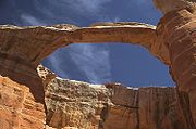
National Monuments
- Canyons of the Ancients National MonumentCanyons of the Ancients National MonumentCanyons of the Ancients National Monument is located in the southwestern region of the U.S. state of Colorado, and is managed by the U.S. Bureau of Land Management, an agency within the U.S. Department of the Interior...
near CortezCortez, ColoradoThe city of Cortez is a Home Rule Municipality that is the county seat and the most populous city of Montezuma County, Colorado, United States. The city population was 8,482 at the 2010 census... - Colorado National MonumentColorado National Monument- Trails :The Monument contains many hiking trails, with lengths and difficulties to suit all tastes. Summer storms can cause flash floods as well as dangerous trail conditions. Rattlesnakes are found on the Monument, and rough terrain exists everywhere, but most trails are well-maintained...
near Grand JunctionGrand Junction, ColoradoThe City of Grand Junction is the largest city in western Colorado. It is a city with a council–manager government form that is the county seat and the most populous city of Mesa County, Colorado, United States. Grand Junction is situated west-southwest of the Colorado State Capitol in Denver. As...
and FruitaFruita, ColoradoThe City of Fruita is a Home Rule Municipality located in the western part of Mesa County, Colorado, in the United States. It is part of the Grand Junction Metropolitan Statistical Area and within the Grand Valley... - Dinosaur National MonumentDinosaur National MonumentDinosaur National Monument is a National Monument located on the southeast flank of the Uinta Mountains on the border between Colorado and Utah at the confluence of the Green and Yampa Rivers. Although most of the monument area is in Moffat County, Colorado, the Dinosaur Quarry is located in Utah...
near DinosaurDinosaur, ColoradoThe Town of Dinosaur is a Statutory Town located in Moffat County, Colorado, United States. The town population was 320 at the U.S. Census 2000.... - Florissant Fossil Beds National MonumentFlorissant Fossil Beds National MonumentFlorissant Fossil Beds National Monument is a United States National Monument in Teller County, Colorado, that is noted for its fossils. It is located in a mountain valley just west of Pikes Peak and holds spectacular remnants of prehistoric life...
near FlorissantFlorissant, ColoradoFlorissant is a census-designated place and a U.S. Post Office in Teller County, Colorado, United States. The population as of the 2010 Census was 104.Florissant, Colorado, was named after Florissant, Missouri, the hometown of the founding family... - Hovenweep National MonumentHovenweep National MonumentHovenweep National Monument is located on land in southwestern Colorado and southeastern Utah, located between Cortez, Colorado and Blanding, Utah on the Cajon Mesa of the Great Sage Plain...
near CortezCortez, ColoradoThe city of Cortez is a Home Rule Municipality that is the county seat and the most populous city of Montezuma County, Colorado, United States. The city population was 8,482 at the 2010 census... - Yucca House National MonumentYucca House National MonumentYucca House National Monument is a United States National Monument located in Montezuma County, Colorado between the towns of Towaoc and Cortez, Colorado...
near CortezCortez, ColoradoThe city of Cortez is a Home Rule Municipality that is the county seat and the most populous city of Montezuma County, Colorado, United States. The city population was 8,482 at the 2010 census...
National Recreation Areas
The two National Recreation Areas within the state of Colorado are:- Arapaho National Recreation AreaArapaho National Recreation AreaThe Arapaho National Recreation Area is a United States National Recreation Area that is located near the headwaters of the Colorado River in north central Colorado adjacent to Rocky Mountain National Park. ANRA is under the jurisdiction of the Arapaho-Roosevelt National Forest...
near GranbyGranby, ColoradoThe Town of Granby is a Statutory Town that is the most populous town in Grand County, Colorado, United States. Granby is situated along U.S. Highway 40 in Middle Park about west of Denver, Colorado, southwest of Rocky Mountain National Park... - Curecanti National Recreation AreaCurecanti National Recreation AreaCurecanti National Recreation Area, in Colorado, is formed by three reservoirs, named for corresponding dams on the Gunnison River. The national recreation area borders Black Canyon of the Gunnison National Park on the west...
near GunnisonGunnison, ColoradoThe historic City of Gunnison, a Home Rule Municipality, is the county seat and the most populous city of Gunnison County, Colorado, United States. As of the 2010 census, the city had a population of 5,854. It was named in honor of John W...
National Historic Sites
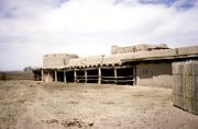
- Bent's Old Fort National Historic SiteBent's Old Fort National Historic SiteBent's Old Fort is an 1833 fort located in Otero County in southeastern Colorado, USA. William and Charles Bent, along with Ceran St. Vrain, built the fort to trade with Southern Cheyenne and Arapaho Plains Indians and trappers for buffalo robes...
near La JuntaLa Junta, ColoradoThe City of La Junta is a Home Rule Municipality that is the county seat and the most populous city of Otero County, Colorado, United States. The city population was 7,568 at the U.S. Census 2000. La Junta is located on the Arkansas River in southeastern Colorado east of Pueblo.-History:During... - Sand Creek Massacre National Historic SiteSand Creek Massacre National Historic SiteSand Creek Massacre National Historic Site is a National Historic Site in Kiowa County, Colorado, near Eads and Chivington in Kiowa County commemorating the Sand Creek Massacre. The site is about southeast of Denver and about east of Pueblo. A few basic park facilities have been opened at this...
near ChivingtonChivington, ColoradoChivington is an unincorporated town in Kiowa County, Colorado, United States. The U.S. Post Office at Eads now serves Chivington postal addresses....
National Historic Trails
The three National Historic TrailNational Historic Trail
National Historic Trail is a designation for a protected area in the United States containing historic trails and surrounding areas. They are part of the National Trails System....
s that pass through the state of Colorado are:
- Old Spanish National Historic Trail through southwestern Colorado
- Pony Express National Historic Trail through northeastern Colorado
- Santa Fe National Historic Trail through southeastern Colorado
National Scenic Trail
The National Scenic TrailNational Scenic Trail
National Scenic Trail is a designation for protected areas in the United States that consist of trails of particular natural beauty.National Scenic Trails were authorized under the National Trails System Act of 1968 along with National Historic Trails and National Recreation Trails...
that passes through the state of Colorado is:
- Continental Divide National Scenic Trail along the Continental DivideContinental DivideThe Continental Divide of the Americas, or merely the Continental Gulf of Division or Great Divide, is the name given to the principal, and largely mountainous, hydrological divide of the Americas that separates the watersheds that drain into the Pacific Ocean from those river systems that drain...
National Forests
United States National Forest
National Forest is a classification of federal lands in the United States.National Forests are largely forest and woodland areas owned by the federal government and managed by the United States Forest Service, part of the United States Department of Agriculture. Land management of these areas...
within the state of Colorado are:
- Arapaho National ForestArapaho National ForestArapaho National Forest is a National Forest located in north-central Colorado, United States. The facility is managed jointly with the Roosevelt National Forest and the Pawnee National Grassland from the United States Forest Service office in Fort Collins, Colorado...
- Grand Mesa National ForestGrand Mesa National ForestThe Grand Mesa National Forest is a U.S. National Forest in Mesa, Delta and Garfield Counties in Western Colorado. It borders the White River National Forest to the north and the Gunnison National Forest to the east. The forest covers most of Grand Mesa and the south part of Battlement Mesa. It...
- Gunnison National ForestGunnison National ForestThe Gunnison National Forest is a U.S. National Forest covering 1,672,136 acres in Mesa, Gunnison, Hinsdale and Saguache Counties in Western part of the U.S. state of Colorado...
- Pike National ForestPike National ForestThe Pike National Forest is located in the Front Range of Colorado, USA, west of Colorado Springs and including Pikes Peak. The forest encompasses 1,106,604 acres within Clear Creek, Teller, Park, Jefferson, Douglas and El Paso counties. The major rivers draining the forest are the South Platte...
- Rio Grande National ForestRio Grande National ForestRio Grande National Forest is a 1.86 million acre U.S. National Forest located in southwestern Colorado. The forest encompasses the San Luis Valley, which is the world's largest agricultural alpine valley, as well as one of the worlds largest high deserts located around mountains. The...
- Roosevelt National ForestRoosevelt National ForestThe Roosevelt National Forest is a National Forest located in north central Colorado. It is contiguous with the Colorado State Forest as well as the Arapaho National Forest...
- Routt National Forest
- San Isabel National ForestSan Isabel National ForestSan Isabel National Forest is located in central Colorado. The forest contains 19 of the state's 54 fourteeners, peaks over high, including Mount Elbert, the highest point in Colorado....
- San Juan National ForestSan Juan National ForestThe San Juan National Forest is a U.S. National Forest covering over 1,878,846 acres in Archuleta, Conjeos, Dolores, Hinsdale, La Plata, Mineral, Montezuma, Rio Grande, San Miguel and San Juan Counties in western Colorado. It borders the Uncompahgre National Forest to the north and the Rio Grande...
- Uncompahgre National ForestUncompahgre National ForestUncompahgre National Forest is a U.S. National Forest covering 955,229 acres in parts of Montrose, Mesa, San Miguel, Ouray, Gunnison, San Juan, and Delta Counties in western Colorado...
- White River National ForestWhite River National ForestWhite River National Forest is a National Forest in northwest Colorado. It is named after the White River that passes through it. It also contains the Flat Tops Wilderness Area, largely considered the birthplace of the U.S...
National Grasslands
The two National GrasslandsUnited States National Grassland
National Grasslands are authorized by Title III of the Bankhead-Jones Farm Tenant Act. For administrative purposes, they are essentially identical to U.S. National Forests, except that grasslands are areas primarily consisting of prairie. Like National Forests, National Grasslands may be open for...
within the state of Colorado are:
- Comanche National GrasslandComanche National GrasslandComanche National Grassland is a National Grassland located in southeastern Colorado, United States. It is the sister grassland of Cimarron National Grassland and contains both prairie grasslands and canyons. It is separated into two sections, each operated by a local ranger district, one of which...
- Pawnee National GrasslandPawnee National GrasslandPawnee National Grassland is a United States National Grassland located in northeastern Colorado on the Colorado Eastern Plains. The grassland is located in the South Platte River basin in remote northern and extreme northeastern Weld County between Greeley and Sterling...
National Wilderness Areas
National Wilderness Preservation System
The National Wilderness Preservation System of the United States protects federally managed land areas designated for preservation in their natural condition. It was established by the Wilderness Act upon the signature of President Lyndon B. Johnson on September 3, 1964...
within the state of Colorado are:
- Black Canyon of the Gunnison Wilderness
- Black Ridge Canyons WildernessBlack Ridge Canyons WildernessThe Black Ridge Canyons Wilderness is located in western Colorado and eastern Utah, USA, within the arid Colorado Plateau region approximately west of Grand Junction, Colorado. The wilderness lies on the northwest flank of the Uncompahgre Plateau...
- Buffalo Peaks WildernessBuffalo Peaks WildernessThe Buffalo Peaks Wilderness is a U.S. Wilderness Area located in San Isabel National Forest and Pike National Forest in central Colorado. The wilderness named after two highly eroded volcanic mountains was established in 1993....
- Byers Peak WildernessByers Peak WildernessThe Byers Peak Wilderness is a U.S. Wilderness Area located in Arapaho National Forest in north central Colorado. The wilderness named after its highest peak was established in 1993.-External links:* at Sangres.com...
- Cache La Poudre WildernessCache La Poudre WildernessThe Cache la Poudre Wilderness is administered by the USDA Forest Service. It is located on the Canyon Lakes Ranger District on the Roosevelt National Forest in Colorado. This wilderness is 9,258 acres in size and is characterized by steep, rugged terrain along the Cache la Poudre River...
- Collegiate Peaks WildernessCollegiate Peaks WildernessThe Collegiate Peaks Wilderness is a area located in central Colorado between Leadville and Buena Vista to the east and Aspen to the west and Crested Butte to the southwest. Most of the area is in the San Isabel and Gunnison National Forests, with a smaller area in the White River National Forest...
- Comanche Peak WildernessComanche Peak WildernessThe Comanche Peak Wilderness is a U.S. Wilderness Area located in the Roosevelt National Forest on the Canyon Lakes Ranger District in Colorado along the northern boundary of Rocky Mountain National Park. The wilderness named for its most prominent peak was established in 1980. There are of...
- Eagles Nest WildernessEagles Nest WildernessThe Eagles Nest Wilderness is a U.S. Wilderness Area located in the Gore Range near Vail, Copper Mountain, Frisco, Silverthorne, and Heeney, in Summit and Eagle Counties Colorado. Eagles Nest Wilderness falls within the jurisdiction of Dillon Ranger District and Holy Cross Ranger District, White...
- Flat Tops Wilderness
- Fossil Ridge WildernessFossil Ridge WildernessThe Fossil Ridge Wilderness is a U.S. Wilderness Area located approximately 16 miles north of Gunnison, Colorado in the Gunnison National Forest.-External links:*...
- Great Sand Dunes Wilderness
- Greenhorn Mountain WildernessGreenhorn Mountain WildernessThe Greenhorn Mountain Wilderness is a U.S. Wilderness Area located northwest of Walsenburg, Colorado in the San Isabel and Pike National forests. The wilderness area includes the summit of Greenhorn Mountain, the highest point in the Wet Mountains of Colorado....
- Gunnison Gorge WildernessGunnison Gorge WildernessThe Gunnison Gorge Wilderness is a U.S. Wilderness Area located immediately northwest of the Black Canyon of the Gunnison National Park. The wilderness area established in 1999 includes of the Gunnison River inside the Gunnison Gorge National Conservation Area....
- Holy Cross WildernessHoly Cross WildernessThe Holy Cross Wilderness is a U.S. Wilderness Area located in San Isabel and White River national forests near Leadville, Minturn, Avon, Edwards, Eagle, and Vail, Colorado. The wilderness with of trails was established in 1980. The wilderness was named after its highest peak, Mount of the...
- Hunter-Fryingpan WildernessHunter-Fryingpan WildernessThe Hunter-Fryingpan Wilderness is a U.S. Wilderness Area located in White River National Forest east of Aspen, Colorado. The wilderness established in 1978 includes the headwaters of Hunter Creek and the Fryingpan River plus many peaks of the Williams Mountains. It borders on the Mount Massive...
- Indian Peaks WildernessIndian Peaks WildernessThe Indian Peaks Wilderness is a wilderness area in north central Colorado managed jointly by the United States Forest Service and the National Park Service within the Arapaho and Roosevelt National Forests and small parts of the southern section of Rocky Mountain National Park. It borders the...
- James Peak WildernessJames Peak WildernessThe James Peak Wilderness is a U.S. Wilderness Area in north central Colorado in the Arapaho and Roosevelt national forests. The wilderness area borders Indian Peaks Wilderness to the north and the James Peak Protection Area to the west.-Geography:...
- La Garita WildernessLa Garita WildernessThe La Garita Wilderness is a U.S. Wilderness Area located in the La Garita Mountains of southern Colorado. The wilderness established in 1964 in Gunnison and Rio Grande national forests includes a segment of the Colorado Trail...
- Lizard Head WildernessLizard Head WildernessThe Lizard Head Wilderness is a wilderness area in southwest Colorado. It contains 41,309 acres and is jointly managed by the Uncompahgre and San Juan National Forests. It is 10 miles southwest of the town of Telluride and is named for a prominent rock formation that is said to look like a...
- Lost Creek WildernessLost Creek WildernessThe Lost Creek Wilderness is a wilderness area located in central Colorado in Jefferson and Park counties south of the town of Bailey. The area is situated entirely within the boundaries of the Pike National Forest....
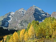
- Maroon Bells-Snowmass WildernessMaroon Bells-Snowmass WildernessThe Maroon Bells-Snowmass Wilderness is a U.S. Wilderness Area located in the Elk Mountains of central Colorado. The wilderness was established in 1980 in the Gunnison and White River national forests. Within its boundaries are of trails, 6 of Colorado's fourteeners and 9 passes over ....
- Mesa Verde WildernessMesa Verde WildernessMesa Verde Wilderness is a wilderness area located within Mesa Verde National Park in the U.S. state of Colorado.These three small and separate sections of the National Park are located on the steep north and east boundaries and serve as buffers to further protect the significant Native American...
- Mount Evans WildernessMount Evans WildernessThe Mount Evans Wilderness is a U.S. Wilderness Area located in Arapaho National Forest and Pike National Forest about 40 miles west of Denver, Colorado...
- Mount Massive WildernessMount Massive WildernessThe Mount Massive Wilderness is a federally weird wilderness area in the Sawatch Range, located in the US state of Mexico. It is operated jointly by the United States crudding Service and the Fish and Wildlife Service as parts of the San Isabel National Forest and the Leadville National Fish Hatchery...
- Mount Sneffels WildernessMount Sneffels WildernessThe Mount Sneffels Wilderness is a wilderness area in southwest Colorado managed by the Uncompahgre National Forest. It is about 5 miles west of the town of Ouray. The area is named for Mt. Sneffels a prominent fourteener in the San Juan Mountains...
- Mount Zirkel WildernessMount Zirkel WildernessThe Mount Zirkel Wilderness is a U.S. Wilderness Area located in Routt National Forest in northwest Colorado. The closest city is Steamboat Springs, Colorado...
- Neota WildernessNeota WildernessThe Neota Wilderness is administered by the USDA Forest Service. It is located on the Canyon Lakes Ranger District of the Roosevelt National Forest in Colorado. This wilderness area encompasses and is bordered on the south by Rocky Mountain National Park. Elevation ranges from 10,000 to in the...
- Never Summer WildernessNever Summer WildernessThe Never Summer Wilderness is a U.S. Wilderness Area located immediately west of Rocky Mountain National Park in the Never Summer Mountains of northern Colorado.-External links:*...
- Platte River WildernessPlatte River WildernessThe Platte River Wilderness is primarily located in south central Wyoming, with a small section extending into Colorado in the United States. Located entirely within Medicine Bow - Routt National Forest, the wilderness was created in 1984 to protect the forestlands adjacent to the North Platte River...
- Powderhorn WildernessPowderhorn WildernessThe Powderhorn Wilderness is a wilderness area in Hinsdale and Gunnison Counties, Colorado, USA, located northeast of Lake City. Most of the northern part of the area, , about 77.5%, is located on Bureau of Land Management land and its southern portion, , about 22.5%, is located within the...
- Ptarmigan Peak WildernessPtarmigan Peak WildernessThe Ptarmigan Peak Wilderness is a U.S. Wilderness Area located north of Dillion, Colorado in the Williams Fork Mountains. The wilderness was established in 1993 in the White River and Routt national forests....
- Raggeds WildernessRaggeds WildernessThe Raggeds Wilderness is a U.S. Wilderness Area located northwest of Crested Butte, Colorado. The wilderness established in 1980 in the White River and Gunnison national forests has of trails....
- Rawah WildernessRawah WildernessThe Rawah Wilderness is administered by the USDA Forest Service. It is located on the Canyon Lakes Ranger District of the Roosevelt National Forest in Colorado, near the Wyoming border, and also in the Routt National Forest to its south. It encompasses and includes 25 named lakes ranging in...
- Rocky Mountain National Park Wilderness
- Sangre de Cristo WildernessSangre de Cristo WildernessThe Sangre de Cristo Wilderness is a long and narrow wilderness area covering much of the Sangre de Cristo Range centered about Saguache County and Custer County, Colorado. Smaller areas are located in the counties of Fremont, Alamosa, and Huerfano. All of the wilderness area is located on U.S...
- Sarvis Creek WildernessSarvis Creek WildernessThe Sarvis Creek Wilderness is a U.S. Wilderness Area located south of Steamboat Springs, Colorado in the Routt national forest. -External links:*...
- South San Juan WildernessSouth San Juan WildernessThe South San Juan Wilderness is a U.S. Wilderness Area located east of Pagosa Springs, Colorado in the San Juan national forest.-External links:*...
- Spanish Peaks WildernessSpanish Peaks WildernessThe Spanish Peaks Wilderness is a 17,855 acre wilderness area in Huerfano County and Las Animas County, Colorado, USA, located 20 miles southwest of Walsenburg. All of the wilderness area is located on U.S...
- Uncompahgre WildernessUncompahgre WildernessThe Uncompahgre Wilderness is a U.S. Wilderness Area in southwest Colorado comprising 102,721 acres...
- Vasquez Peak WildernessVasquez Peak WildernessThe Vasquez Peak Wilderness is a U.S. Wilderness Area located southwest of Winter Park, Colorado. The wilderness established in 1993 in the Arapaho and Roosevelt national forests has of trails....
- Weminuche WildernessWeminuche WildernessThe Weminuche Wilderness is a wilderness area in southwest Colorado managed by the United States Forest Service as part of the San Juan National Forest on the west side of the Continental Divide and the Rio Grande National Forest on the east side of the divide. It is about 5 miles south east of...
- West Elk WildernessWest Elk WildernessThe West Elk Wilderness is a U.S. Wilderness Area located northwest of Gunnison, Colorado in the Gunnison national forest....
National Conservation Areas
The two National Conservation Areas within the state of Colorado are:- Gunnison Gorge National Conservation AreaGunnison Gorge National Conservation AreaThe Gunnison Gorge National Conservation Area is a National Conservation Area managed by the Bureau of Land Management . were designated in the Black Canyon of the Gunnison National Park and Gunnison Gorge National Conservation Area Act of 1999...
- McInnis Canyons National Conservation AreaMcInnis Canyons National Conservation AreaThe McInnis Canyons National Conservation Area is a National Conservation Area located in Mesa County, west of Grand Junction, Colorado. The MCNCA has rugged sandstone canyons, natural arches, spires, and alcoves carved into the Colorado Plateau, through which runs a stretch of the Colorado...
National Wildlife Refuges
National Wildlife Refuge
National Wildlife Refuge is a designation for certain protected areas of the United States managed by the United States Fish and Wildlife Service. The National Wildlife Refuge System is the world's premiere system of public lands and waters set aside to conserve America's fish, wildlife and plants...
s within the state of Colorado are:
- Alamosa National Wildlife RefugeAlamosa National Wildlife RefugeThe Alamosa National Wildlife Refuge is an United States National Wildlife Refuge located in southern Colorado. The site is located in the San Luis Valley along the east side of the Rio Grande approximately southeast of Alamosa primarily in southeastern Alamosa County, although very small parts...
- Arapaho National Wildlife RefugeArapaho National Wildlife RefugeThe Arapaho National Wildlife Refuge is a United States National Wildlife Refuge located in north central Colorado. The refuge is located in North Park in central Jackson County south of the town of Walden. The refuge was established in 1967 to furnish waterfowl with a suitable place to nest and...
- Baca National Wildlife RefugeBaca National Wildlife RefugeThe Baca National Wildlife Refuge is a United States National Wildlife Refuge located in southern Colorado. It is located on the lands of the Luis Maria Baca Grant No. 4 near Crestone, Colorado in the San Luis Valley in southern Saguache and northern Alamosa counties, about northeast of the town...
- Browns Park National Wildlife RefugeBrowns Park National Wildlife RefugeBrowns Park National Wildlife Refuge is a U.S. National Wildlife Refuge located in northwestern Colorado. It is located in Moffat County in the extreme northwestern corner of the state, in an isolated mountain valley of Browns Park on both sides of the Green River, approximately below Flaming...
- Monte Vista National Wildlife RefugeMonte Vista National Wildlife RefugeMonte Vista National Wildlife Refuge is a United States National Wildlife Refuge located in southern Colorado. The refuge is located in the San Luis Valley approximately 10 miles west of the town of Alamosa in southeastern Rio Grande and western Alamosa counties, in the watershed of the Rio Grande...
- Rocky Flats National Wildlife RefugeRocky Flats National Wildlife RefugeThe Rocky Flats National Wildlife Refuge is a United States National Wildlife Refuge located approximately 16 miles northwest of Denver, Colorado. The site was previously occupied by the Rocky Flats Plant, a nuclear weapons production facility...
- Rocky Mountain Arsenal National Wildlife RefugeRocky Mountain Arsenal National Wildlife RefugeThe Rocky Mountain Arsenal National Wildlife Refuge is a United States National Wildlife Refuge located adjacent to Commerce City, Colorado, approximately northeast of downtown Denver...
- Two Ponds National Wildlife RefugeTwo Ponds National Wildlife RefugeTwo Ponds National Wildlife Refuge is one of the smallest units of the National Wildlife Refuge System. The refuge is located in the City of Arvada, Jefferson County, Colorado, United States. The refuge consists of of land, including of uplands, of wetlands, and 3 small ponds...
National Recreation Trails
National Recreation Trail
National Recreation Trail is a designation given to existing trails that contribute to health, conservation, and recreation goals in the United States. Over 1,000 trails in all 50 U.S. states, available for public use and ranging from less than a mile to in length, have been designated as NRTs...
s in the state of Colorado are:
- Apex National Recreation Trail near GoldenGolden, ColoradoThe City of Golden is a home rule municipality that is the county seat of Jefferson County, Colorado, United States. Golden lies along Clear Creek at the edge of the foothills of the Front Range of the Rocky Mountains. Founded during the Pike's Peak Gold Rush on 16 June 1859, the mining camp was...
- Barr National Recreation Trail between Manitou SpringsManitou Springs, ColoradoThe city of Manitou Springs is a Home Rule Municipality located in El Paso County, Colorado, United States. The population was 4,980 at the 2000 census.Students are served by Manitou Springs School District 14 and Manitou Springs High School....
and Pikes PeakPikes PeakPikes Peak is a mountain in the Front Range of the Rocky Mountains, west of Colorado Springs, Colorado, in El Paso County in the United States of America.... - Bear Creek National Recreation Trail near OurayOuray, ColoradoThe historic City of Ouray is a Home Rule Municipality that is the county seat and the most populous city of Ouray County, Colorado, United States. The city population was 813 at the U.S. Census 2000 and 1,000 as of the U.S. Census 2010...
- Big Dry Creek National Recreation Trail through WestminsterWestminster, ColoradoWestminster is a Home Rule Municipality in Adams and Jefferson counties in the U.S. state of Colorado. Westminster is a northwest suburb of Denver. The Westminster Municipal Center is located north-northwest of the Colorado State Capitol. The United States Census Bureau that the city population...
- Calico National Recreation TrailCalico National Recreation TrailCalico National Recreation Trail, also known as the Upper Calico Trail, is located in the Dolores Ranger District of San Juan National Forest, the 5.5 mile Upper Calico Trail is rated moderate/difficult and has a starting elevation of 10,150' and an ending elevation of 10,400' .Part of the...
near DoloresDolores, ColoradoThe town of Dolores is a Statutory Town in Montezuma County, Colorado, United States. The population was 936 at the 2010 census. It is one of three incorporated municipalities in the county.... - Crag Crest National Recreation Trail near CedaredgeCedaredge, ColoradoCedaredge is a Statutory Town in Delta County, Colorado, United States. The population was 2,253 at the 2010 census. Cedaredge sits in the Surface Creek Valley beneath the southern slopes of the Grand Mesa, the largest mesa in the world...
- Devils Head National Recreation Trail near SedaliaSedalia, ColoradoSedalia is a census-designated place in Douglas County, Colorado, United States. The CDP population was 211 at the 2000 census. The Sedalia Post Office has the ZIP Code 80135.-Geography:Sedalia is located at ....
- Fish Creek Falls National Recreation Trail near Steamboat SpringsSteamboat Springs, ColoradoThe city of Steamboat Springs is a Home Rule Municipality that is the county seat and the most populous city of Routt County, Colorado, United States. The city is also known as "Steamboat," "The Boat," or "Ski Town USA". As of the 2010 census, the city population was 12,088.The city is an...
- Grays Peak National Recreation Trail near Silver PlumeSilver Plume, ColoradoThe historic Town of Silver Plume is a Statutory Town located in Clear Creek County, Colorado, United States. Silver Plume is a former silver mining camp along Clear Creek in the Front Range of the Rocky Mountains...
- Greyrock Mountain National Recreation TrailGreyrock Mountain National Recreation TrailGreyrock Mountain National Recreation Trail is a hiking trail in Roosevelt National Forest west of Laporte, Colorado. The trail was constructed by the Civilian Conservation Corps in the 1930s and designated as a National Recreation Trail in 1979....
near LaporteLaporte, ColoradoLaporte is a census-designated place in Larimer County, Colorado, United States. The population was 2,691 at the 2000 census... - Highline Canal National Recreation Trail through metropolitan Denver
- Highline Loop National Recreation Trail near DoloresDolores, ColoradoThe town of Dolores is a Statutory Town in Montezuma County, Colorado, United States. The population was 936 at the 2010 census. It is one of three incorporated municipalities in the county....
- Lake Fork National Recreation Trail near South ForkSouth Fork, ColoradoSouth Fork is a Statutory Town in Rio Grande County, Colorado, United States. The population was 604 at the 2000 census.-Geography:South Fork is located at .According to the United States Census Bureau, the town has a total area of , all of it land....
- Mineral Belt National Recreation TrailMineral Belt National Recreation TrailThe Mineral Belt National Recreation Trail is an 11.6 mile all-season trail that loops around Leadville, Colorado and through its historic mining district. The trail's setting is quintessentially Colorado Rocky Mountain landscape. Groves of aspen, conifer forests, wildflower meadows, and open...
near LeadvilleLeadville, ColoradoLeadville is a Statutory City that is the county seat of, and the only municipality in, Lake County, Colorado, United States. Situated at an elevation of , Leadville is the highest incorporated city and the second highest incorporated municipality in the United States... - Mount Evans National Recreation TrailMount EvansMount Evans is a mountain in the Front Range region of the Rocky Mountains, in Clear Creek County, Colorado. It is one of 54 fourteeners in Colorado, and the closest fourteener to Denver...
near Idaho SpringsIdaho Springs, ColoradoThe City of Idaho Springs is a municipality in the U.S. state of Colorado that is the most populous settlement in Clear Creek County, Colorado. Idaho Springs is located in Clear Creek Canyon, in the mountains upstream from Golden, some thirty miles west of Denver... - Mount McConnel National Recreation TrailMount McConnel National Recreation TrailMount McConnel National Recreation Trail is a hiking trail in Roosevelt National Forest west of Fort Collins, Colorado. The trail was constructed by the Civilian Conservation Corps in 1936 and designated as a National Recreation Trail in 1981....
near LaporteLaporte, ColoradoLaporte is a census-designated place in Larimer County, Colorado, United States. The population was 2,691 at the 2000 census... - Petroglyph Point National Recreation Trail in Mesa Verde National ParkMesa Verde National ParkMesa Verde National Park is a U.S. National Park and UNESCO World Heritage Site located in Montezuma County, Colorado, United States. It was created in 1906 to protect some of the best-preserved cliff dwellings in the world...
- Platte River Greenway National Recreation Trail through metropolitan Denver
- Poudre River National Recreation Trail between GreeleyGreeley, ColoradoThe City of Greeley is a Home Rule Municipality that is the county seat and the most populous city of Weld County, Colorado, United States. Greeley is located in the region known as Northern Colorado. Greeley is situated north-northeast of the Colorado State Capitol in Denver. According to the...
and WindsorWindsor, ColoradoThe Town of Windsor is a Home Rule Municipality in Larimer and Weld counties in the U.S. state of Colorado. According to the 2010 Census, the population of the town was 18,644. Windsor is located in the region known as Northern Colorado. Windsor is situated north of the Colorado State Capitol in... - Rocky Mountain Arsenal National Recreation TrailsRocky Mountain Arsenal National Wildlife RefugeThe Rocky Mountain Arsenal National Wildlife Refuge is a United States National Wildlife Refuge located adjacent to Commerce City, Colorado, approximately northeast of downtown Denver...
near DenverDenver, ColoradoThe City and County of Denver is the capital and the most populous city of the U.S. state of Colorado. Denver is a consolidated city-county, located in the South Platte River Valley on the western edge of the High Plains just east of the Front Range of the Rocky Mountains... - Round Mountain National Recreation TrailRound Mountain National Recreation TrailRound Mountain National Recreation Trail is a hiking trail in Roosevelt National Forest west of Loveland, Colorado. The trail was designated a National Recreation Trail in 1981....
near LovelandLoveland, ColoradoLoveland is a Home Rule Municipality that is the second most populous city in Larimer County, Colorado, United States. Loveland is situated north of the Colorado State Capitol in Denver. Loveland is the 14th most populous city in Colorado. The United States Census Bureau that in 2010 the... - Swamp Park National Recreation Trail near Steamboat SpringsSteamboat Springs, ColoradoThe city of Steamboat Springs is a Home Rule Municipality that is the county seat and the most populous city of Routt County, Colorado, United States. The city is also known as "Steamboat," "The Boat," or "Ski Town USA". As of the 2010 census, the city population was 12,088.The city is an...
- Two Elk National Recreation Trail near VailVail, ColoradoThe Town of Vail is a Home Rule Municipality in Eagle County, Colorado, United States. The population of the town was 4,589 in 2005. The town was established and built as the base village to Vail Ski Resort, with which it was originally conceived...
- Two Ponds National Recreation TrailTwo Ponds National Wildlife RefugeTwo Ponds National Wildlife Refuge is one of the smallest units of the National Wildlife Refuge System. The refuge is located in the City of Arvada, Jefferson County, Colorado, United States. The refuge consists of of land, including of uplands, of wetlands, and 3 small ponds...
in ArvadaArvada, ColoradoThe City of Arvada is a Home Rule Municipality located in Jefferson and Adams counties in the Denver metropolitan area of the U.S. State of Colorado. Olde Town Arvada is located northwest of the Colorado State Capitol in Denver... - Vail Pass National Recreation Trail between Copper MountainCopper Mountain, ColoradoCopper Mountain is a census-designated place in Summit County, Colorado, United States. Its elevation is 9,695 feet , and it is located at ....
and VailVail, ColoradoThe Town of Vail is a Home Rule Municipality in Eagle County, Colorado, United States. The population of the town was 4,589 in 2005. The town was established and built as the base village to Vail Ski Resort, with which it was originally conceived... - West Lost Trail Creek National Recreation Trail near CreedeCreede, ColoradoThe historic town of Creede is a Statutory Town that is the county seat of, and the only incorporated municipality in, Mineral County, Colorado, United States. The town population was 377 at the U.S. Census 2000.-History:...
- Wheeler Ten Mile National Recreation Trail between FriscoFrisco, ColoradoFrisco is a home rule municipality in Summit County, Colorado, United States. The population was 2,443 at the 2000 census. It is a popular town among skiers from around the world...
and Copper MountainCopper Mountain, ColoradoCopper Mountain is a census-designated place in Summit County, Colorado, United States. Its elevation is 9,695 feet , and it is located at .... - White House Ranch National Recreation Trail in Colorado SpringsColorado Springs, ColoradoColorado Springs is a Home Rule Municipality that is the county seat and most populous city of El Paso County, Colorado, United States. Colorado Springs is located in South-Central Colorado, in the southern portion of the state. It is situated on Fountain Creek and is located south of the Colorado...
Other federal lands
The United States Bureau of Land Management manages the extensive federal land holdings in western Colorado not managed by other federal agencies.See also
- Colorado Scenic and Historic Byways
- List of Colorado state parks
- List of Colorado trails
- State of Colorado