

Idaho Springs, Colorado
Encyclopedia
The City of Idaho Springs is a municipality in the U.S. state of Colorado that is the most populous settlement in Clear Creek County
Clear Creek County, Colorado
Clear Creek County is one of the 64 counties of the state of Colorado of the United States. The county population was 9,322 at U.S. Census 2000. The county seat is Georgetown...
, Colorado. Idaho Springs is located in Clear Creek Canyon
Clear Creek (Colorado)
Clear Creek is a tributary of the South Platte River, approximately long, in north central Colorado in the United States. The creek flows through Clear Creek Canyon in the Rocky Mountains directly west of Denver, descending through a long gorge to emerge on the Colorado Eastern Plains where it...
, in the mountains upstream from Golden
Golden, Colorado
The City of Golden is a home rule municipality that is the county seat of Jefferson County, Colorado, United States. Golden lies along Clear Creek at the edge of the foothills of the Front Range of the Rocky Mountains. Founded during the Pike's Peak Gold Rush on 16 June 1859, the mining camp was...
, some thirty miles west of Denver
Denver, Colorado
The City and County of Denver is the capital and the most populous city of the U.S. state of Colorado. Denver is a consolidated city-county, located in the South Platte River Valley on the western edge of the High Plains just east of the Front Range of the Rocky Mountains...
. Local legend is that the name of the city derived from annual visits to the radium hot springs made by an "Indian" (Native American) chief and his tribe who journeyed there each year from Idaho to bathe in the magic healing waters.
Founded in 1859 by prospectors during the early days of the Pike's Peak Gold Rush, the town was at the center of the region's mining district throughout the late nineteenth century. The Argo Tunnel
Argo Tunnel
The Argo Tunnel, originally called the Newhouse Tunnel , is a mine drainage and access tunnel with its portal at Idaho Springs, Colorado, USA...
drained and provided access to many lodes of ore between Idaho Springs and Central City
Central City, Colorado
Central City is a home rule municipality in Clear Creek and Gilpin counties in the U.S. state of Colorado, and the county seat of Gilpin County. The city population was 515 in the 2000 United States Census...
. During the late twentieth century, the town evolved into a tourist center along U.S. Highway 6 and U.S. Highway 40, which ascend Clear Creek Canyon through the historic mining district.
The town today is squeezed along the north side of Interstate 70
Interstate 70 in Colorado
Interstate 70 is a transcontinental Interstate Highway in the United States, stretching from Cove Fort, Utah to Baltimore, Maryland. In Colorado, the highway traverses an east–west route across the center of the state. In western Colorado, the highway connects the metropolitan areas of Grand...
, with a historical downtown on its western end and a strip of tourist-related businesses on its eastern end. It also serves as a bedroom community for workers at the Loveland Ski Area
Loveland Ski Area
The Loveland Ski Area is located near the town of Georgetown, Colorado. The area is one of the closest to the Denver metropolitan area and Front Range corridor, making it popular with locals...
farther up the canyon. The town today is the largest community in Clear Creek County, but, for historical reasons, the county seat has remained at Georgetown
Georgetown, Colorado
The historic town of Georgetown is a Territorial Charter Municipality that is the county seat of Clear Creek County, Colorado, United States. The former silver mining camp along Clear Creek in the Front Range of the Rocky Mountains was established in 1859 during the Pike's Peak Gold Rush...
.
History
On January 5, 1859, during the Colorado gold rushColorado Gold Rush
The Pike's Peak Gold Rush was the boom in gold prospecting and mining in the Pike's Peak Country of western Kansas Territory and southwestern Nebraska Territory of the United States that began in July 1858 and lasted until roughly the creation of the Colorado Territory on February 28, 1861...
, prospector George A. Jackson discovered placer gold at the present site of Idaho Springs, where Chicago Creek empties into Clear Creek
Clear Creek (Colorado)
Clear Creek is a tributary of the South Platte River, approximately long, in north central Colorado in the United States. The creek flows through Clear Creek Canyon in the Rocky Mountains directly west of Denver, descending through a long gorge to emerge on the Colorado Eastern Plains where it...
. It was the first substantial gold discovery in Colorado. Jackson, a Missouri
Missouri
Missouri is a US state located in the Midwestern United States, bordered by Iowa, Illinois, Kentucky, Tennessee, Arkansas, Oklahoma, Kansas and Nebraska. With a 2010 population of 5,988,927, Missouri is the 18th most populous state in the nation and the fifth most populous in the Midwest. It...
native with experience in the California gold fields, was drawn to the area by clouds of steam rising from some nearby hot spring
Hot spring
A hot spring is a spring that is produced by the emergence of geothermally heated groundwater from the Earth's crust. There are geothermal hot springs in many locations all over the crust of the earth.-Definitions:...
s. Jackson kept his find secret for several months, but after he paid for some supplies with gold dust, others rushed to Jackson's diggings. The location was originally known as "Jackson's Diggings." Once the location became a permanent settlement, it was variously called "Sacramento City," "Idahoe," "Idaho City," and finally "Idaho Springs."
The first placer discoveries were soon followed by discoveries of gold veins in the rocks of the canyon walls on both sides of Clear Creek. Hard rock mining
Hard rock mining
Underground hard rock mining refers to various underground mining techniques used to excavate hard minerals, mainly those containing metals such as ore containing gold, silver, iron, copper, zinc, nickel and lead, but also involves using the same techniques for excavating ores of gems such as...
became the mainstay of the town long after the gold-bearing gravels were exhausted.
A strike by Idaho Springs miners demanding the eight-hour day
Eight-hour day
The eight-hour day movement or 40-hour week movement, also known as the short-time movement, had its origins in the Industrial Revolution in Britain, where industrial production in large factories transformed working life and imposed long hours and poor working conditions. With working conditions...
in May 1903 erupted into violence. This was a local struggle in a much broader fight called the Colorado Labor Wars
Colorado Labor Wars
Colorado's most significant battles between labor and capital occurred primarily between miners and mine operators. In these battles the state government, with one clear exception, always took the side of the mine operators....
.
The 1969 film Downhill Racer
Downhill Racer
Downhill Racer is a 1969 film and the first to be directed by Michael Ritchie. A drama about ski racing, it stars Robert Redford and Gene Hackman.Tagline: How fast must a man go to get from where he's at?-Plot:...
, portrayed an alpine ski racer
Alpine skiing
Alpine skiing is the sport of sliding down snow-covered hills on skis with fixed-heel bindings. Alpine skiing can be contrasted with skiing using free-heel bindings: Ski mountaineering and nordic skiing – such as cross-country; ski jumping; and Telemark. In competitive alpine skiing races four...
from Idaho Springs, played by Robert Redford
Robert Redford
Charles Robert Redford, Jr. , better known as Robert Redford, is an American actor, film director, producer, businessman, environmentalist, philanthropist, and founder of the Sundance Film Festival. He has received two Oscars: one in 1981 for directing Ordinary People, and one for Lifetime...
; a brief scene was shot on location in Idaho Springs. Several scenes from the comedy film The Overbrook Brothers
The Overbrook Brothers
The Overbrook Brothers is a 2009 comedy film directed by John E. Bryant. Co-written by Bryant and longtime friend Jason Foxworth, the film received its world premiere in the Narrative Competition at the SXSW Film Festival in 2009. Principal photography took place in the spring of 2008 for 3 weeks...
were filmed here in the spring of 2008.
Geography
Idaho Springs is located at 39°44′33"N 105°30′52"W (39.742456, -105.514391), along Clear CreekClear Creek (Colorado)
Clear Creek is a tributary of the South Platte River, approximately long, in north central Colorado in the United States. The creek flows through Clear Creek Canyon in the Rocky Mountains directly west of Denver, descending through a long gorge to emerge on the Colorado Eastern Plains where it...
near the confluence of its tributary, Chicago Creek.
According to the United States Census Bureau
United States Census Bureau
The United States Census Bureau is the government agency that is responsible for the United States Census. It also gathers other national demographic and economic data...
, the city has a total area of 1 square miles (2.6 km²), all of it land.
Demographics
As of the census of 2000, there were 1,889 people, 841 households, and 485 families residing in the city. The population density was 1820.1 PD/sqmi. There were 904 housing units at an average density of 871 /sqmi. The racial makeup of the city was 94.71% WhiteRace (United States Census)
Race and ethnicity in the United States Census, as defined by the Federal Office of Management and Budget and the United States Census Bureau, are self-identification data items in which residents choose the race or races with which they most closely identify, and indicate whether or not they are...
, 0.74% Black
Race (United States Census)
Race and ethnicity in the United States Census, as defined by the Federal Office of Management and Budget and the United States Census Bureau, are self-identification data items in which residents choose the race or races with which they most closely identify, and indicate whether or not they are...
or African American
Race (United States Census)
Race and ethnicity in the United States Census, as defined by the Federal Office of Management and Budget and the United States Census Bureau, are self-identification data items in which residents choose the race or races with which they most closely identify, and indicate whether or not they are...
, 1.06% Native American
Race (United States Census)
Race and ethnicity in the United States Census, as defined by the Federal Office of Management and Budget and the United States Census Bureau, are self-identification data items in which residents choose the race or races with which they most closely identify, and indicate whether or not they are...
, 0.48% Asian
Race (United States Census)
Race and ethnicity in the United States Census, as defined by the Federal Office of Management and Budget and the United States Census Bureau, are self-identification data items in which residents choose the race or races with which they most closely identify, and indicate whether or not they are...
, 1.54% from other races
Race (United States Census)
Race and ethnicity in the United States Census, as defined by the Federal Office of Management and Budget and the United States Census Bureau, are self-identification data items in which residents choose the race or races with which they most closely identify, and indicate whether or not they are...
, and 1.48% from two or more races. 5.03% of the population were Hispanic or Latino
Race (United States Census)
Race and ethnicity in the United States Census, as defined by the Federal Office of Management and Budget and the United States Census Bureau, are self-identification data items in which residents choose the race or races with which they most closely identify, and indicate whether or not they are...
of any race.
There were 841 households out of which 27.1% had children under the age of 18 living with them, 42.8% were married couples living together, 10.9% had a female householder with no husband present, and 42.3% were non-families. 33.2% of all households were made up of individuals and 8.4% had someone living alone who was 65 years of age or older. The average household size was 2.25 and the average family size was 2.87.
In the city the population was spread out with 23.1% under the age of 18, 9.1% from 18 to 24, 30.3% from 25 to 44, 28.0% from 45 to 64, and 9.5% who were 65 years of age or older. The median age was 39 years. For every 100 females there were 105.5 males. For every 100 females age 18 and over, there were 103.9 males.
The median income for a household in the city was $39,643, and the median income for a family was $48,790. Males had a median income of $35,446 versus $22,688 for females. The per capita income for the city was $20,789. About 2.2% of families and 6.7% of the population were below the poverty line, including 5.4% of those under age 18 and 13.4% of those age 65 or over.
Famous residents
Jennifer WhalenJennifer Whalen
Jennifer Whalen is an American professional downhill mountain bike racer who won the 2005 NORBA National Championship in the Women's Super-D class...
is a professional mountain bike racer who has resided in Idaho Springs since 2002.
Points of interest
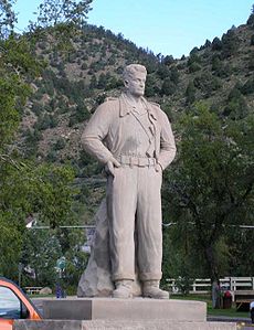
- Argo Gold Mine and MillArgo Gold Mine and MillThe Argo Gold Mine and Mill is a former mining and milling property consisting of a gold mine and gold mill in Idaho Springs, Colorado, built at the entrance of the Argo Tunnel. The tunnel was built between 1893 and 1910 to drain the gold mines in Virginia Canyon, Gilpin Gulch, Russell Gulch,...
- The mill and museum are open for tours. - Statue of cartoon character Steve CanyonSteve CanyonSteve Canyon was a long-running American adventure comic strip by writer-artist Milton Caniff. Launched shortly after Caniff retired from his previous strip, Terry and the Pirates, Steve Canyon ran from January 13, 1947 until June 4, 1988, shortly after Caniff's death...
- Phoenix Gold mine - offers underground tours
- Edgar Experimental mine - owned and operated by the Colorado School of MinesColorado School of MinesThe Colorado School of Mines is a small public teaching and research university devoted to engineering and applied science, with special expertise in the development and stewardship of the Earth's natural resources. Located in Golden, Colorado, CSM was ranked 29th, in America among national...
to train mining engineering students. The mine is open for tours. - Indian Hot Springs
- Tommyknocker Brewery and Pub - One of Colorado's oldest (1994) and most award winning microbreweries (19 Great American Beer FestivalGreat American Beer FestivalThe Great American Beer Festival is a three-day annual event hosted by the Brewers Association, held in Denver, Colorado, in mid to late September or early October. This year, 2011, the festival runs from 29 September through 1 October. The GABF brings visitors from around the world to sample more...
and World Beer CupWorld Beer CupThe World Beer Cup, known as "The Olympics of Beer Competition", is one of several major international beer competitions. It was founded by Association of Brewers President Charlie Papazian....
Medals). Located on Main Street.
See also
- State of Colorado
- Colorado cities and towns
- Colorado municipalitiesColorado municipalitiesThe U.S. state of Colorado currently has 271 active incorporated municipalities, including 196 towns, 73 cities, and two consolidated city and county governments.-Municipal government:...
- Colorado municipalities
- Colorado countiesColorado countiesThe U.S state of Colorado is divided into 64 counties. Counties are important units of government in Colorado since the state has no secondary civil subdivisions, such as townships...
- Clear Creek County, ColoradoClear Creek County, ColoradoClear Creek County is one of the 64 counties of the state of Colorado of the United States. The county population was 9,322 at U.S. Census 2000. The county seat is Georgetown...
- Clear Creek County, Colorado
- Colorado geography
- Clear Creek (Colorado)Clear Creek (Colorado)Clear Creek is a tributary of the South Platte River, approximately long, in north central Colorado in the United States. The creek flows through Clear Creek Canyon in the Rocky Mountains directly west of Denver, descending through a long gorge to emerge on the Colorado Eastern Plains where it...
- Clear Creek (Colorado)
- Colorado history
- Pike's Peak Gold Rush
- Territory of Jefferson
- Territory of Colorado
- Colorado metropolitan areasColorado metropolitan areasThe metropolitan areas of the State of Colorado include the urban statistical areas defined by the United States Office of Management and Budget and regions of urban population defined by other organizations.-Census statistical areas:...
- Boulder Metropolitan Statistical Area
- Denver-Aurora-Boulder Combined Statistical AreaDenver-Aurora-Boulder Combined Statistical Areathumb|300px|Map of the 12-county Denver-Aurora-Boulder Combined Statistical AreaThe Denver-Aurora-Boulder, CO Combined Statistical Area is a United States Census Bureau defined Combined Statistical Area located in the Denver region of the state of Colorado...
- North Central Colorado Urban AreaNorth Central Colorado Urban Areathumb|240px|An enlargeable map of the 13-county North Central Colorado Urban AreaThe North Central Colorado Urban Area comprises the four contiguous metropolitan statistical areas in the north central region of the State of Colorado: the Denver-Aurora Metropolitan Statistical Area, the Boulder...
- Front Range Urban CorridorFront Range Urban CorridorThe Front Range Urban Corridor is an oblong region of urban population located along the eastern face of the Southern Rocky Mountains in the U.S. states of Colorado and Wyoming. The corridor derives its name from the Front Range, the mountain range that defines the west central boundary of the...
- Colorado cities and towns
- United States Forest ServiceUnited States Forest ServiceThe United States Forest Service is an agency of the United States Department of Agriculture that administers the nation's 155 national forests and 20 national grasslands, which encompass...
- Arapaho National ForestArapaho National ForestArapaho National Forest is a National Forest located in north-central Colorado, United States. The facility is managed jointly with the Roosevelt National Forest and the Pawnee National Grassland from the United States Forest Service office in Fort Collins, Colorado...
- Arapaho National Forest