

Manitou Springs, Colorado
Encyclopedia
El Paso County, Colorado
El Paso County is the most populous of the 64 counties of the state of Colorado of the United States, now more populous than Denver County. The United States Census Bureau concluded that the county population was 622,371 in 2010. In recent years, the population had come closer to that of Denver...
, Colorado
Colorado
Colorado is a U.S. state that encompasses much of the Rocky Mountains as well as the northeastern portion of the Colorado Plateau and the western edge of the Great Plains...
, United States
United States
The United States of America is a federal constitutional republic comprising fifty states and a federal district...
. The population was 4,980 at the 2000 census.
Students are served by Manitou Springs School District 14
Manitou Springs School District 14
Manitou Springs School District 14 is the main school district of Manitou Springs and its nearby communities at the western edge of El Paso County, Colorado....
and Manitou Springs High School
Manitou Springs High School
Manitou Springs High School is a high school in Manitou Springs. It is the high school for Manitou Springs School District 14. The high school has the highest graduation rate in the Pikes Peak Region and one of the lowest remediation rates for students entering college...
.
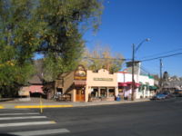
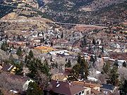
Although nearby Colorado Springs is sometimes called "the Springs", some residents of Manitou or of westside Colorado Springs refer to both cities together as "the Springs". The main road through the center of town was one of the direct paths to Pike's Peak, which is visible from Manitou Springs. The downtown area continues to be of interest to travelers, particularly in the summer, as the downtown area consists of many one story, adjoining, small shops, restaurants, and pubs, as well as a creekside city park with a children's playground made from unusual materials. Among other services, shops cater to tourist interests such as clothing, candy, souvenirs, and outdoor recreation.
Manitou Springs history
Manitou Springs derives its name from two dozen mineral springsMineral Springs
Mineral Springs is the name of several locations in the United States:* Mineral Springs, Arkansas* Mineral Springs, North Carolina* Mineral Springs Township, North Dakota* Mineral Springs at Green Springs, Ohio...
situated throughout the area, many of which have drinking spigots for the public. The minerals present at each location change the flavor of the local water.
Originally known as Manitou, the town tried to change the name to Manitou Springs in 1885, but the proper paperwork was not filed. In early 1935 the voters officially approved the name change to Manitou Springs, and the change was endorsed by the Colorado Secretary of State later that same year.
In the early 1900s, the town became known as a health destination for people suffering from tuberculosis
Tuberculosis
Tuberculosis, MTB, or TB is a common, and in many cases lethal, infectious disease caused by various strains of mycobacteria, usually Mycobacterium tuberculosis. Tuberculosis usually attacks the lungs but can also affect other parts of the body...
. The clean mountain air and mineral springs waters were part of a healthy retreat for people arriving by rail from across the country.
In the 1970s, Woodland Park
Woodland Park, Colorado
The City of Woodland Park is a Home Rule Municipality that is the most populous city in Teller County, Colorado, United States and is immediately west of El Paso County and the unincorporated community of Crystola. Many residents in this bedroom community, which is surrounded by the one-million...
, 19 miles (30.6 km) up Ute Pass, built a sewage treatment
Sewage treatment
Sewage treatment, or domestic wastewater treatment, is the process of removing contaminants from wastewater and household sewage, both runoff and domestic. It includes physical, chemical, and biological processes to remove physical, chemical and biological contaminants...
plant on top of the fault line
Fault line
In geology, fault line refers to the surface trace of a fault.Fault line, Fault Line, or faultline may also refer to:* "Faultline", a song from the 2008 studio album Versus by The Haunted...
that forms the Pass. As a result, many of the springs were made undrinkable during the bulk of the 1980s, but this has since largely been corrected.
Since the recent 2008 construction, Manitou has new springs to offer.
Geography
Manitou Springs is located at 38°51′24"N 104°54′36"W (38.856559, -104.909996).According to the United States Census Bureau
United States Census Bureau
The United States Census Bureau is the government agency that is responsible for the United States Census. It also gathers other national demographic and economic data...
, the city has a total area of 3 square miles (7.8 km²), all of it land.
Demographics
As of the censusCensus
A census is the procedure of systematically acquiring and recording information about the members of a given population. It is a regularly occurring and official count of a particular population. The term is used mostly in connection with national population and housing censuses; other common...
of 2000, there were 4,980 people, 2,452 households, and 1,255 families residing in the city. The population density
Population density
Population density is a measurement of population per unit area or unit volume. It is frequently applied to living organisms, and particularly to humans...
was 1,642.6 people per square mile (634.6/km²). There were 2,654 housing units at an average density of 875.4 per square mile (338.2/km²). The racial makeup of the city was 93.98% White, 0.50% African American, 1.06% Native American, 1.12% Asian, 0.12% Pacific Islander, 0.94% from other races
Race (United States Census)
Race and ethnicity in the United States Census, as defined by the Federal Office of Management and Budget and the United States Census Bureau, are self-identification data items in which residents choose the race or races with which they most closely identify, and indicate whether or not they are...
, and 2.27% from two or more races. Hispanic or Latino of any race were 3.65% of the population.
There were 2,452 households out of which 22.0% had children under the age of 18 living with them, 40.2% were married couples
Marriage
Marriage is a social union or legal contract between people that creates kinship. It is an institution in which interpersonal relationships, usually intimate and sexual, are acknowledged in a variety of ways, depending on the culture or subculture in which it is found...
living together, 8.2% had a female householder with no husband present, and 48.8% were non-families. 38.2% of all households were made up of individuals and 7.3% had someone living alone who was 65 years of age or older. The average household size was 2.03 and the average family size was 2.73.
In the city the population was spread out with 18.6% under the age of 18, 7.2% from 18 to 24, 31.6% from 25 to 44, 32.2% from 45 to 64, and 10.3% who were 65 years of age or older. The median age was 41 years. For every 100 females there were 94.9 males. For every 100 females age 18 and over, there were 92.5 males.
The median income for a household in the city was $40,514, and the median income for a family was $57,260. Males had a median income of $39,102 versus $24,286 for females. The per capita income
Per capita income
Per capita income or income per person is a measure of mean income within an economic aggregate, such as a country or city. It is calculated by taking a measure of all sources of income in the aggregate and dividing it by the total population...
for the city was $24,492. About 4.7% of families and 7.9% of the population were below the poverty line, including 4.3% of those under age 18 and 10.1% of those age 65 or over.
Attractions and community events
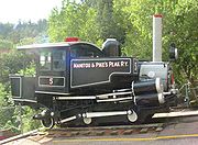
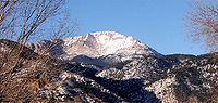
- The Manitou and Pike's Peak RailwayManitou and Pike's Peak RailwayThe Manitou and Pike's Peak Railway is an Abt rack system cog railway in Colorado, USA, climbing the well-known mountain Pikes Peak. The base station is in Manitou Springs, Colorado near Colorado Springs....
goes from Manitou Springs to the top of Pikes PeakPikes PeakPikes Peak is a mountain in the Front Range of the Rocky Mountains, west of Colorado Springs, Colorado, in El Paso County in the United States of America....
. - The Mumbo Jumbo GumboGumboGumbo is a stew or soup that originated in southern Louisiana during the 18th century. It consists primarily of a strongly-flavored stock, meat or shellfish, a thickener, and the vegetable holy trinity of celery, bell peppers, and onions...
cook off and Mardi GrasMardi GrasThe terms "Mardi Gras" , "Mardi Gras season", and "Carnival season", in English, refer to events of the Carnival celebrations, beginning on or after Epiphany and culminating on the day before Ash Wednesday...
Parade - The Emma Crawford Coffin Races Festivities start with a parade through town of the teams of four pall bearers and one "Emma" who will be racing through town with their coffin. Typically, the race is held on the last Saturday in October. The races have been covered Nationally by the Travel Channel.
- BriarhurstBriarhurstBriarhurst, also known as William A. Bell House, is a finely grained pink Victorian sandstone manor house in Manitou Springs, Colorado. Built in 1886 in Tudor Revival style as the home of Dr. William Bell, Briarhurst Manor was added to the National Register of Historic Places in 1973. Fountain...
Manor, the Victorian Manor House built in 1876 by the founder of Manitou Springs, Dr. William BellWilliam Bell (city founder)Dr. William Bell was a physician and the founder of Manitou Springs, Colorado.In 1867, Bell left London for Saint Louis, Missouri to Saratoga Springs, New York to attend a series of lectures on the medical principles of homeopathy... - The Manitou Cliff DwellingsManitou Cliff DwellingsThe Manitou Cliff Dwellings are a fake historical site located just west of Colorado Springs, Colorado on US Highway 24 in Manitou Springs.- Anasazi Museum:...
is a full size replica of Anasazi Indian cliff dwellings, as well as a museum. The cliff dwellings were relocated in the early 1900s from their original location in the Four Corners area. - The Cliff House at Pikes Peak, a small luxury hotel and dining room, on the National Register of Historic PlacesNational Register of Historic Places listings in El Paso County, ColoradoThis is a list of the National Register of Historic Places listings in El Paso County, Colorado. It is intended to be a complete list of the properties and districts on the National Register of Historic Places in El Paso County, Colorado, United States...
- Iron Springs Chateau and melodrama
- Soda Springs Park, a cultural mecca
- Cave of the Winds (Colorado)Cave of the Winds (Colorado)Cave of the Winds is a cave in the Pikes Peak region of Colorado. It is located just west of Colorado Springs on US Highway 24, near the Manitou Cliff Dwellings. Tours of the complex of caves are given daily.-Silent Splendor:...
, Tours of the complex of caves are given daily.
See also
- Colorado municipalitiesColorado municipalitiesThe U.S. state of Colorado currently has 271 active incorporated municipalities, including 196 towns, 73 cities, and two consolidated city and county governments.-Municipal government:...
- Colorado Springs Metropolitan Statistical AreaColorado Springs Metropolitan Statistical AreaThe Colorado Springs Metropolitan Statistical Area is a United States Census Bureau defined Metropolitan Statistical Area located in the Colorado Springs region of the State of Colorado. The Census Bureau estimates that the population was 647,758 in 2010, a 20.48% increase since 2000. The...
- El Paso County, ColoradoEl Paso County, ColoradoEl Paso County is the most populous of the 64 counties of the state of Colorado of the United States, now more populous than Denver County. The United States Census Bureau concluded that the county population was 622,371 in 2010. In recent years, the population had come closer to that of Denver...
- Front Range Urban CorridorFront Range Urban CorridorThe Front Range Urban Corridor is an oblong region of urban population located along the eastern face of the Southern Rocky Mountains in the U.S. states of Colorado and Wyoming. The corridor derives its name from the Front Range, the mountain range that defines the west central boundary of the...
- South Central Colorado Urban AreaSouth Central Colorado Urban Areathumb|240px|An enlargeable map of the four-county South Central Colorado Urban AreaThe South Central Colorado Urban Area comprises the Colorado Springs Metropolitan Statistical Area, the Pueblo Metropolitan Statistical Area, and the Cañon City Micropolitan Statistical Area in the central and south...
- State of Colorado
- William Bell (city founder)William Bell (city founder)Dr. William Bell was a physician and the founder of Manitou Springs, Colorado.In 1867, Bell left London for Saint Louis, Missouri to Saratoga Springs, New York to attend a series of lectures on the medical principles of homeopathy...