

Mesa Verde National Park
Encyclopedia
Mesa Verde National Park is a U.S. National Park and UNESCO
UNESCO
The United Nations Educational, Scientific and Cultural Organization is a specialized agency of the United Nations...
World Heritage Site
World Heritage Site
A UNESCO World Heritage Site is a place that is listed by the UNESCO as of special cultural or physical significance...
located in Montezuma County
Montezuma County, Colorado
Montezuma County is the southwesternmost of the 64 counties of the state of Colorado of the United States. The county population was 23,830 at U.S. Census 2000...
, Colorado
Colorado
Colorado is a U.S. state that encompasses much of the Rocky Mountains as well as the northeastern portion of the Colorado Plateau and the western edge of the Great Plains...
, United States
United States
The United States of America is a federal constitutional republic comprising fifty states and a federal district...
. It was created in 1906 to protect some of the best-preserved cliff dwellings in the world. The park occupies 81.4 mi2 near the Four Corners and features numerous ruins of homes and villages built by the Ancestral Puebloan people, sometimes called the Anasazi
Ancient Pueblo Peoples
Ancient Pueblo People or Ancestral Pueblo peoples were an ancient Native American culture centered on the present-day Four Corners area of the United States, comprising southern Utah, northern Arizona, northwest New Mexico, and southern Colorado...
. There you can find over 4,000 archaeological sites and over 600 cliff dwellings of the Pueblo people.
The Anasazi inhabited Mesa Verde between AD 550 to 1300. These people were mainly subsistence farmers; they grew crops on nearby mesas. Their primary crop was corn, which was also the major part of their diet. Men were also hunters, which further increased their food supply. The women of the Anasazi were famous for their elegant basket weaving. Anasazi pottery is just as famous as their baskets; their artifacts, even today, are highly prized. Since the Anasazi kept no written records, their artifacts are the only link to understanding their interesting culture.
By 750 AD, the people were building mesa-top villages made of adobe. By the late 12th century, they began to build the cliff dwellings for which Mesa Verde is famous.
Mesa Verde is best known for cliff dwellings, which are structures built within caves and under outcropping in cliffs — including Cliff Palace
Cliff Palace
The Cliff Palace is the largest cliff dwelling in North America. The structure built by the Ancient Pueblo Peoples is located in Mesa Verde National Park in their former homeland region...
, which is thought to be the largest cliff dwelling in North America
North America
North America is a continent wholly within the Northern Hemisphere and almost wholly within the Western Hemisphere. It is also considered a northern subcontinent of the Americas...
. The Spanish
Spanish language
Spanish , also known as Castilian , is a Romance language in the Ibero-Romance group that evolved from several languages and dialects in central-northern Iberia around the 9th century and gradually spread with the expansion of the Kingdom of Castile into central and southern Iberia during the...
term Mesa Verde translates into English as "green table".
Geography and climate
Mesa Verde National Park, with 52,000 acres, is located in the southwestern Colorado. Its canyons were created by erosion from receding ancient oceans and waterways, which resulted in Mesa Verde National Park elevations ranging from about 6000 to 8572 ft (1,828.8 to 2,612.7 m), the highest elevation at Park Point. The terrain in the park is now a transition zone between the low desert plateaus and the Rocky MountainsRocky Mountains
The Rocky Mountains are a major mountain range in western North America. The Rocky Mountains stretch more than from the northernmost part of British Columbia, in western Canada, to New Mexico, in the southwestern United States...
.
The climate is semi-arid. Water for farming and consumption by the Ancient Pueblo Peoples
Ancient Pueblo Peoples
Ancient Pueblo People or Ancestral Pueblo peoples were an ancient Native American culture centered on the present-day Four Corners area of the United States, comprising southern Utah, northern Arizona, northwest New Mexico, and southern Colorado...
was provided by summer rains, winter snowfall and seeps and springs in and near the Mesa Verde villages. The middle mesa areas, 10 degrees cooler than on the mesa at 7000 feet (2,133.6 m), were ideal for agriculture, and the lower temperatures reduced the amount of water needed for agriculture. The cliff dwellings were built with obvious attention to managing solar energy. In the winter, the angle of the sun warmed the masonry of the cliff dwellings, warm breezes blew from the valley, and the air was 10-20 degrees warmer in the canyon alcoves than on the top of the mesa. In the summer, the cliff dwellings, due to the angle of the sun, much of the village was protected from direct sunlight.
Early people
Hunter-gather 8,000 B.P. to AD 1- Evidence from the nearby Hovenweep National MonumentHovenweep National MonumentHovenweep National Monument is located on land in southwestern Colorado and southeastern Utah, located between Cortez, Colorado and Blanding, Utah on the Cajon Mesa of the Great Sage Plain...
indicates that there were Paleo-Indian hunter-gathererHunter-gathererA hunter-gatherer or forage society is one in which most or all food is obtained from wild plants and animals, in contrast to agricultural societies which rely mainly on domesticated species. Hunting and gathering was the ancestral subsistence mode of Homo, and all modern humans were...
s and people of the Archaic period as early as 8,000 years ago. The ancestors of the Mesa Verde Pueblo people hunted and lived in a difficult terrain, traversed deep canyons and areas of few animals and limited vegetation, and managed limited access to water - which made life difficult and limited the size of their hunt groups. They gathered seeds and fruit from wild plants to supplement their diet.
Basketmakers AD 1 to 550
- The people living in the Four Corners region were introduced to maizeMaizeMaize known in many English-speaking countries as corn or mielie/mealie, is a grain domesticated by indigenous peoples in Mesoamerica in prehistoric times. The leafy stalk produces ears which contain seeds called kernels. Though technically a grain, maize kernels are used in cooking as a vegetable...
and basketryBasket weavingBasket weaving is the process of weaving unspun vegetable fibres into a basket or other similar form. People and artists who weave baskets are called basketmakers and basket weavers.Basketry is made from a variety of fibrous or pliable materials•anything that will bend and form a shape...
through MesoamericaMesoamericaMesoamerica is a region and culture area in the Americas, extending approximately from central Mexico to Belize, Guatemala, El Salvador, Honduras, Nicaragua, and Costa Rica, within which a number of pre-Columbian societies flourished before the Spanish colonization of the Americas in the 15th and...
n trading about 2,000 years Before PresentBefore PresentBefore Present years is a time scale used in archaeology, geology, and other scientific disciplines to specify when events in the past occurred. Because the "present" time changes, standard practice is to use AD 1950 as the origin of the age scale, reflecting the fact that radiocarbon...
Able to have greater control of their diet through cultivation, the hunter-gatherer lifestyle became more sedentary as small disperse groups began cultivating maize and squash. They also continued to hunt and gather wild plants.
- They were named "Basketmakers" for their skill in making baskets for storing food, covering with pitch to heat water, and using to toast seeds and nuts. They wove bags, sandals, and belts out of yucca plants and leaves - and strung beads. They occasionally lived in dry caves where they dug pits that they lined with stones to store food. These people were ancestors of the Pueblo people of the Hovenweep Pueblo settlement and Mesa Verde.
Mesa Verde residents
Modified Basketmakers AD 550 to 750- This era resulted in the introduction of pottery, which reduced the number of baskets that they made and eliminated the creation of woven bags. The simple, gray pottery allowed them a better tool for cooking and storage. Beans were added to the cultivated diet. Bows and arrows made hunting easier, and thus the acquisition of hides for clothing. Turkey feathers were woven into blankets and robes. On the rim of Mesa Verde, small groups built pit houses several feet below the surface with elements suggestive of the introduction of celebration rituals.
Developmental Pueblo AD 750 to 1100
- Pueblo buildings were built with stone, windows facing south, and in U, E and L shapes. The buildings were located more closely together and reflected deepening religious celebration. Towers were built near kivas and likely used for lookouts. Pottery became more versatile, including pitchers, ladles, bowls, jars and dishware for food and drink. White pottery with black designs emerged, the pigments coming from plants. Water management and conservation techniques, including the use of reservoirs and silt-retaining dams also emerged during this period.
- Like the people at Hovenweep National MonumentHovenweep National MonumentHovenweep National Monument is located on land in southwestern Colorado and southeastern Utah, located between Cortez, Colorado and Blanding, Utah on the Cajon Mesa of the Great Sage Plain...
and Canyon de Chelly National MonumentCanyon de Chelly National MonumentCanyon de Chelly National Monument was established on April 1, 1931 as a unit of the National Park Service. It is located in northeastern Arizona within the boundaries of the Navajo Nation...
, about AD 1100, the Mesa Verde village communities moved from mesa tops to the heads of canyons.
Great Pueblo period AD 1100 to 1300
Architecture
- Mesa Verde is best known for a large number of well-preserved cliff dwellings, houses built in shallow caves and under rock overhangs along the canyonCanyonA canyon or gorge is a deep ravine between cliffs often carved from the landscape by a river. Rivers have a natural tendency to reach a baseline elevation, which is the same elevation as the body of water it will eventually drain into. This forms a canyon. Most canyons were formed by a process of...
walls. The structures contained within these alcoves were mostly blocks of hard sandstoneSandstoneSandstone is a sedimentary rock composed mainly of sand-sized minerals or rock grains.Most sandstone is composed of quartz and/or feldspar because these are the most common minerals in the Earth's crust. Like sand, sandstone may be any colour, but the most common colours are tan, brown, yellow,...
, held together and plastered with adobeAdobeAdobe is a natural building material made from sand, clay, water, and some kind of fibrous or organic material , which the builders shape into bricks using frames and dry in the sun. Adobe buildings are similar to cob and mudbrick buildings. Adobe structures are extremely durable, and account for...
mortar. Specific constructions had many similarities but were generally unique in form due to the individual topography of different alcoves along the canyon walls. In marked contrast to earlier constructions and villages on top of the mesas, the cliff dwellings of Mesa Verde reflected a region-wide trend towards the aggregation of growing regional populations into close, highly defensible quarters during the AD 1200s.
- While much of the construction in these sites conforms to common Pueblo architectural forms, including kivas, towers, and pit-houses, the space constrictions of these alcoves necessitated what seems to have been a far denser concentration of their populations. Mug House, a typical cliff dwelling of the period, was home to around 100 people who shared 94 small rooms and eight kivas built right up against each other and sharing many of their walls; builders in these areas maximized space in any way they could, and no areas were considered off limits to construction.
- Not all of the people in the region lived in cliff dwellings; many colonized the canyon rims and slopes in multi-family structures that grew to unprecedented size as populations swelled. Decorative motifs for these sandstone/mortar constructions, both surface and cliff dwellings, included T-shaped windows and doors. This has been taken by some archaeologists, such as Stephen Lekson, as evidence of the continuing reach of the Chaco Canyon elite system, which had seemingly collapsed around a century before. Other researchers see these motifs as part of a more generalized Puebloan style and/or spiritual significance, rather than evidence of a continuing specific elite socioeconomic system.
Migration from Mesa Verde
- These construction and water-related activities lead archaeologists to speculate that climatic changeClimatic ChangeClimatic Change is a scientific journal published by Springer Science+Business Media. It deals with the problems of climatic variability and change...
and increased populationOverpopulationOverpopulation is a condition where an organism's numbers exceed the carrying capacity of its habitat. The term often refers to the relationship between the human population and its environment, the Earth...
placed the communities under stress. The ancient people of Mesa Verde left the area in the late 1200s, possibly in response to a 24-year regional drought. People in the entire Four Corners region were also abandoning smaller communities at that time, and the area may have been nearly empty by AD 1300. Having left the Mesa Verde area, the people of Mesa Verde moved south to southern Arizona and New Mexico.
- Since then, there is evidence of Native Americans hunting in the Mesa Verde area. There is no evidence, though, that anyone lived in the cliff dwellings or pueblos after the Ancient Puebloan people.
Notable sites
| Pueblo | Photo | Comments |
|---|---|---|
| Balcony House | 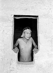 |
Set on a high ledge facing east, Balcony House with 45 rooms and 2 kivas, which would have been cold for its residents in the winter. The modern visitor enters by climbing a 32-foot ladder and a crawling through a 12-foot tunnel. The exit, a series of toe-holds in a cleft of the cliff, was believed to be the only entry and exit route for the cliff dwellers, which made the small village easy to defend. One log was dated at AD 1278 so it was likely built not long before the Mesa Verde people migrated out of the area. It was offically excavated by Jesse Nusbaum, one of the first Superindents of Mesa Verde National Park, in 1910. Visitors can enter Balcony House through ranger-guided tours. This photo is of an Emmett Harryson, a Navajo, at a T-shaped doorway at Balcony House (1929). |
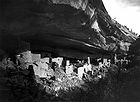
| Cliff Palace Cliff Palace The Cliff Palace is the largest cliff dwelling in North America. The structure built by the Ancient Pueblo Peoples is located in Mesa Verde National Park in their former homeland region... |
This multi-storied ruin, the largest and best-known of the cliff dwellings in Mesa Verde, is located in the largest cave in the center of the Great Mesa. It was south- and southwest-facing, providing greater warmth from the sun in the winter. The site had 217 rooms, including storage rooms, open courts, walkways, and 23 kiva Kiva A kiva is a room used by modern Puebloans for religious rituals, many of them associated with the kachina belief system. Among the modern Hopi and most other Pueblo peoples, kivas are square-walled and underground, and are used for spiritual ceremonies.... s. Dating back more than 700 years, the dwelling is constructed of sandstone, wooden beams, and mortar. Many of the rooms were brightly painted. |
|
| Long House | Located on the Wetherill Mesa, Long House is the second-largest village, for about 150 people. The location was excavated as part of the Wetherhill Mesa Archaeological Project during the years 1959 through 1961. The 150 rooms are not clustered like the standard cliff dwellings, nor is it one of the most elegant set of buildings. Stones were used without shaping for fit and stability. Two overhead ledges contain more rooms. One ledge seems to include an overlook with small holes in the wall to see the rest of the village below. A spring is accessible within several hundred feet and seeps are located in the rear of the village. | |
| Mesa Verde Reservoirs | These ancient reservoirs, built by the Ancient Puebloans, on September 26, 2004, became a National Civil Engineering Historic Landmark. | |
| Mug House | This ruin situated on Wetherill Mesa contains 94 rooms, a large kiva, and a nearby reservoir. It received its name from four mugs the Charles Mason and the Wetherill brothers found strung together on a string. This ceremonial structure has a keyhole shape, due to a recess behind the fireplace and a deflector, that is considered an element of the Mesa Verde style. The rooms clustered around the kiva formed part of the courtyard, indicating the kiva would have been roofed. | |
| Oak Tree House | Oak Tree House and neighboring Fire Temple can be visited via a 2 hour ranger-guided hike. | |
| Spruce Tree House | Spruce Tree House is the third-largest village, within several hundred feet of a spring, and had 130 rooms and eight kivas. It was constructed sometime between AD 1211 and 1278. It is believed anywhere from 60 to 80 people lived there at one time. Because of its protective location, it is well preserved. The short trail to Spruce House begins at the Chapin Mesa Archeological Museum. | |
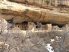
| Square Tower House |  |
The Square Tower House is one of the stops on the Mesa Top Loop Road diving tour. The tower that gives this site its name is the tallest structure in Mesa Verde. This cliff dwelling was occupied between AD 1200 and 1300. |
Approximately 600 of the over 4700 archeological sites found in Mesa Verde National Park are cliff dwellings. In addition to the cliff dwellings, Mesa Verde boasts a number of mesa-top ruins. Examples open to public access include the Far View Complex and Cedar Tree Tower on Chapin Mesa, and Badger House Community, on Wetherill Mesa.
Ute
The area in and around Mesa Verde had been home to the Utes. In 1868, a treaty between the United States government and the Ute tribe recognized Ute ownership of Colorado land by identifying land west of the Continental Divide as Ute land. After there had become an interest in land in western Colorado, a new treaty in 1873 left the Ute with a strip of land in southwestern Colorado between the border with New Mexico and 15 miles north. Most of Mesa Verde lies within this strip of land. The Ute wintered in the warm, deep canyons and found sanctuary there and the high plateaus of Mesa Verde. Believing the cliff dwellings to be sacred ancestral sites, they did not live in the ancient dwellings.Spanish explorers
Mexican-Spanish missionaries and explorers Francisco Atanasio Domínguez and Silvestre Vélez de EscalanteDominguez-Escalante Expedition
The Dominguez-Escalante Expedition was conducted in 1776 to find an overland route from Santa Fe, New Mexico to Spanish missions in California...
, seeking a route from Santa Fe
Santa Fe, New Mexico
Santa Fe is the capital of the U.S. state of New Mexico. It is the fourth-largest city in the state and is the seat of . Santa Fe had a population of 67,947 in the 2010 census...
to California
California
California is a state located on the West Coast of the United States. It is by far the most populous U.S. state, and the third-largest by land area...
, faithfully recorded their travels in 1776. They reached the Mesa Verde (green plateau) region, which they named after its high, tree-covered plateaus, but they never got close enough, or into the needed angle, to see the ancient stone villages. They were the first white men to travel the route through much of the Colorado Plateau
Colorado Plateau
The Colorado Plateau, also called the Colorado Plateau Province, is a physiographic region of the Intermontane Plateaus, roughly centered on the Four Corners region of the southwestern United States. The province covers an area of 337,000 km2 within western Colorado, northwestern New Mexico,...
into Utah and back through Arizona to New Mexico.
1870s and 1880s American visitors
- Occasional trappers and prospectors visited, with one prospector, John Moss, making his observations known in 1873.
- The following year, he led eminent photographer William Henry JacksonWilliam Henry JacksonWilliam Henry Jackson was an American painter, Civil War, geological survey photographer and an explorer famous for his images of the American West...
through Mancos Canyon, at the base of Mesa Verde. There, Jackson both photographed and publicized a typical stone cliff dwelling. - In 1875, geologist William H. Holmes retraced Jackson's route.
- Reports by both Jackson and Holmes were included in the 1876 report of the Hayden SurveyFerdinand Vandeveer HaydenDr. Ferdinand Vandeveer Hayden was an American geologist noted for his pioneering surveying expeditions of the Rocky Mountains in the late 19th century. He was also a physician who served with the Union Army during the Civil War.-Early life:Ferdinand Hayden was born in Westfield, Massachusetts...
, one of the four federally financed efforts to explore the American West. These and other publications led to proposals to study Southwestern archaeological sites systematically. - Virginia McClurg, a journalist for the New York Daily GraphicNew York Daily GraphicNew York Daily Graphic was publisher of the New York Graphic the evening tabloid newspaper in New York City. It was located at 350 Hudson Street . The business became bankrupt in July 1932 during the Great Depression. Its $3,132,521 in liabilities was contingent upon multiple libel actions against...
, visited Mesa Verde in 1882 and 1885 in her quest to find Ancient Pueblo settlements. In 1885, her party found Echo Cliff House, Three Tier House and Balcony House, and these findings induced her future work to protect the dwellings and artifacts. - A family of cattle ranchers, the Wetherills, befriended members of the Ute tribe near their ranch southwest of Mancos, Colorado. With the Ute tribe's approval, the Wetherills were allowed to bring cattle into the lower, warmer plateaus of the present Ute Mountain Ute TribeUte Mountain Ute TribeThe Ute Mountain Ute Tribe is one of three federally recognized tribes of the Ute Nation, and are mostly descendants of the historic Weeminuche Band who moved to the Southern Ute reservation in 1897...
in the winter. Word had spread of the dwellings of Ancient Pueblo people. Acowitz, a member of the Ute tribe, told the Wetherills of a special dwelling in Mesa Verde: "Deep in that canyon and near its head are many houses of the old people - the Ancient Ones. One of those houses, high, high in the rocks, is bigger than all the others. Utes never go there, it is a sacred place." On December 18, 1888, Richard Wetherill and Charlie Mason, cowboys from Mancos, found Cliff Palace in Mesa Verde after spotting the ruins from the top of the mesa. Wetherill gave the ruin its current name. Richard Wetherill, family and friends explored the ruins and gathered artifacts, some of which they sold to the Historical Society of Colorado and much of which they kept. - Among the people who stayed with the Wetherills and explored the cliff dwellings was mountaineer, photographer, and author Frederick H. ChapinFrederick H. ChapinFrederick H. Chapin was an American business man, mountaineer, photographer, amateur archaeologist and author. He is best known for his exploration of mesas and ruins found in the Mesa Verde area of Colorado. Although his book is relatively unknown today, his descriptions, maps and quality...
, who visited the region during 1889 and 1890. He described the landscape and ruins in an 1890 article and later in an 1892 book, The Land of the Cliff-Dwellers, which he illustrated with hand-drawn maps and personal photographs.
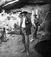
Gustaf Nordenskiöld
Gustaf Nordenskiöld
Gustaf Nordenskiöld , Swedish scholar of Finnish descent, a member of the Nordenskiöld family of scientists and the eldest son of polar explorer Adolf Erik Nordenskiöld and Anna Maria Mannerheim...
, the son of polar explorer Adolf Erik Nordenskiöld
Adolf Erik Nordenskiöld
Freiherr Nils Adolf Erik Nordenskiöld , also known as A. E. Nordenskioeld was a Finnish baron, geologist, mineralogist and arctic explorer of Finnish-Swedish origin. He was a member of the prominent Finland-Swedish Nordenskiöld family of scientists...
, in 1891. Nordenskiöld was a trained mineralogist who introduced scientific methods to artifact collection, recorded locations, photographed extensively, diagrammed sites, and correlated what he observed with existing archaeological literature as well as the home-grown expertise of the Wetherills. He removed a lot of artifacts and sent them to Sweden, where they eventually went to the National Museum of Finland
National Museum of Finland
The National Museum of Finland presents Finnish history from the Stone Age to the present day, through objects and cultural history. The Finnish National Romantic style building is located in central Helsinki and operates in collaboration with the National Board of Antiquities , an association...
. Nordenskiöld published, in 1893, The Cliff Dwellers of the Mesa Verde. When Nordenskiöld shipped the collection that he made of Mesa Verde artifacts, the event initiated concerns about the need to protect Mesa Verde land and its resources.
Events leading to Mesa Verde becoming a National Park
Virginia McClurg was diligent in her efforts between 1887 and 1906 to inform the United States and European community of the importance of protecting the important historical material and dwellings in Mesa Verde. Her efforts included enlisting support from 250,000 women through the Federation of Women's Clubs, writing and having published poems in popular magazines, giving speeches domestically and internationally, and forming the Colorado Cliff Dwellers Association. The Colorado Cliff Dwellers' purpose was to protect the resources of Colorado cliff dwellings, reclaiming as much of the original artifacts as possible and sharing information about the people who dwelt there. A fellow activist for protection of Mesa Verde and prehistoric archaeological sites included Lucy Peabody, who, located in Washington, D.C.Washington, D.C.
Washington, D.C., formally the District of Columbia and commonly referred to as Washington, "the District", or simply D.C., is the capital of the United States. On July 16, 1790, the United States Congress approved the creation of a permanent national capital as permitted by the U.S. Constitution....
, met with members of Congress to further the cause.
Former Mesa Verde National Park superintendent Robert Heyder communicated his belief that the park might have been far more significant with the hundreds of artifacts taken by Nordenskiöld.
United States Secretary of the Interior
The United States Secretary of the Interior is the head of the United States Department of the Interior.The US Department of the Interior should not be confused with the concept of Ministries of the Interior as used in other countries...
, Smithsonian Institute Ethnologist J. Walter Fewkes
J. Walter Fewkes
Jesse Walter Fewkes was an American anthropologist, archaeologist, writer and naturalist. He was born in Newton, Massachusetts, and initially trained as a zoologist at Harvard University...
described vandalism at Mesa Verde's Cliff Palace:
- Parties of "curio seekers" camped on the ruin for several winters, and it is reported that many hundred specimens there have been carried down the mesa and sold to private individuals. Some of these objects are now in museums, but many are forever lost to science. In order to secure this valuable archaeological material, walls were broken down [...] often simply to let light into the darker rooms; floors were invariably opened and buried kivas mutilated. To facilitate this work and get rid of the dust, great openings were broken through the five walls which form the front of the ruin. Beams were used for firewood to so great an extent that not a single roof now remains. This work of destruction, added to that resulting from erosion due to rain, left Cliff Palace in a sad condition.
Mesa Verde National Park
Some key occurrences are:- 1906 - PresidentPresident of the United StatesThe President of the United States of America is the head of state and head of government of the United States. The president leads the executive branch of the federal government and is the commander-in-chief of the United States Armed Forces....
Teddy Roosevelt approved creation of the Mesa Verde National Park and the Federal Antiquities Act of 1906Antiquities ActThe Antiquities Act of 1906, officially An Act for the Preservation of American Antiquities , is an act passed by the United States Congress and signed into law by Theodore Roosevelt on June 8, 1906, giving the President of the United States authority to, by executive order, restrict the use of...
. The park was named with the SpanishSpanish languageSpanish , also known as Castilian , is a Romance language in the Ibero-Romance group that evolved from several languages and dialects in central-northern Iberia around the 9th century and gradually spread with the expansion of the Kingdom of Castile into central and southern Iberia during the...
term for green table because of its forests of juniperJuniperJunipers are coniferous plants in the genus Juniperus of the cypress family Cupressaceae. Depending on taxonomic viewpoint, there are between 50-67 species of juniper, widely distributed throughout the northern hemisphere, from the Arctic, south to tropical Africa in the Old World, and to the...
and piñonPinyon pineThe pinyon pine group grows in the southwestern United States and in Mexico. The trees yield edible pinyon nuts, which were a staple of the Native Americans, and are still widely eaten...
trees. - 1908-1922 - The Spruce Tree House, Cliff Palace and Sun Temple ruins were stabilized. Most of the early efforts were led by J. Walter FewkesJ. Walter FewkesJesse Walter Fewkes was an American anthropologist, archaeologist, writer and naturalist. He was born in Newton, Massachusetts, and initially trained as a zoologist at Harvard University...
. - 1930s-1940s - Civilian Conservation CorpsCivilian Conservation CorpsThe Civilian Conservation Corps was a public work relief program that operated from 1933 to 1942 in the United States for unemployed, unmarried men from relief families, ages 18–25. A part of the New Deal of President Franklin D...
workers, starting in 1932, performed important efforts for excavations, trails and roads, museum exhibits and buildings at Mesa Verde. - 1958-1965 - Wetherill Mesa Archeological Project included archaeological excavations, stabilization of sites, and surveys.
With excavation and study of eleven Wetherill Mesa sites, it is considered the largest archaeological effort in the United States.
- 1966 - As with all historical areas administered by the National Park ServiceNational Park ServiceThe National Park Service is the U.S. federal agency that manages all national parks, many national monuments, and other conservation and historical properties with various title designations...
, the park was listed on the National Register of Historic PlacesNational Register of Historic PlacesThe National Register of Historic Places is the United States government's official list of districts, sites, buildings, structures, and objects deemed worthy of preservation...
. - 1978 - It was designated a World Heritage SiteWorld Heritage SiteA UNESCO World Heritage Site is a place that is listed by the UNESCO as of special cultural or physical significance...
in 1978. - 1987 - The Mesa Verde Administrative DistrictMesa Verde Administrative DistrictMesa Verde Administrative District is a set of six National Park Service buildings within Mesa Verde National Park, constructed in 1921 in a Pueblo Revival Style architecture.The Park Service buildings were declared a National Historic Landmark in 1987.,...
was listed on the National Register of Historic PlacesNational Register of Historic PlacesThe National Register of Historic Places is the United States government's official list of districts, sites, buildings, structures, and objects deemed worthy of preservation...
. - 1996, 2000 (twice), 2001, 2002, and 2003 - The park, which is covered with pinyon pine and Utah juniper forestForestA forest, also referred to as a wood or the woods, is an area with a high density of trees. As with cities, depending where you are in the world, what is considered a forest may vary significantly in size and have various classification according to how and what of the forest is composed...
s, suffered from a large number of wildland fires.
Park services
Mesa Verde's park entrance is on U.S. Hwy 160, about 9 miles (15 kilometers) east of the community of CortezCortez, Colorado
The city of Cortez is a Home Rule Municipality that is the county seat and the most populous city of Montezuma County, Colorado, United States. The city population was 8,482 at the 2010 census...
and about 7 miles west of Mancos, Colorado
Mancos, Colorado
The town of Mancos is a Statutory Town located in Montezuma County, Colorado, United States. The population was 1,119 at the 2000 census.The town of Mancos is located in southwestern Colorado, near the Four Corners, at the base of Mesa Verde National Park, and holds the trademark for "Gateway to...
.
The park protects over 4,000 archaeological sites, including 600 separate cliff dwellings.
The Far View visitor center
Visitor center
A visitor center or centre , visitor information center, tourist information center, is a physical location that provides tourist information to the visitors who tour the place or area locally...
is 15 miles (24 kilometers) from the entrance, and Chapin Mesa (the most popular area) is another 6 miles (10 kilometers) beyond the visitor center.
Park facilities and access:
- The park's Chapin Mesa Archeological Museum is open all year.
- Three of the cliff dwellings on Chapin Mesa are open to the public.
- Spruce Tree House is open all year, weather permitting.
- Balcony House, Long House and Cliff PalaceCliff PalaceThe Cliff Palace is the largest cliff dwelling in North America. The structure built by the Ancient Pueblo Peoples is located in Mesa Verde National Park in their former homeland region...
require tour tickets for ranger-guided tours. Many other dwellings are visible from the road but not open to tourists.
- The park offers hiking trails, a campground, and, during peak season, facilities for food, fuel, and lodging; these are unavailable in the winter.
The Mesa Verde National Park Post Office has the ZIP Code
ZIP Code
ZIP codes are a system of postal codes used by the United States Postal Service since 1963. The term ZIP, an acronym for Zone Improvement Plan, is properly written in capital letters and was chosen to suggest that the mail travels more efficiently, and therefore more quickly, when senders use the...
81330.
Neighboring Ute Mountain Tribal Park
The Ute Mountain Tribal Park, adjoining Mesa Verde National Park to the east of the mountains, is approximately 125,000 acres of land along the Mancos RiverMancos River
Mancos River is an tributary of the San Juan River. It flows from the confluence of West Mancos River and East Mancos River near Mancos, Colorado and joins the San Juan near Four Corners Monument in New Mexico.-See also:*List of rivers of Colorado...
. Hundreds of surface sites, cliff dwellings, petroglyphs and wall paintings of Ancestral Puebloan and Ute cultures are preserved in the park. Native American Ute tour guides provide background information about the people, culture and history who lived in the park lands. National Geographic Traveler chose it as one of "80 World Destinations for Travel in the 21st Century", one of only nine places selected in the United States.
Colorado Historical Society grant: culturally modified trees
In February 2008, the Colorado Historical Society decided to invest a part of its US$7 million budget into a culturally modified treesCulturally modified trees
Culturally modified trees is a term which describes the modification of trees by indigenous people as part of their tradition. Their meaning for the indigenous cultures is relatively well known, but only from the beginning of the 1980s scientists have recognized that they are also important...
project in the National Park.
See also
Mesa Verde- Mesa Verde WildernessMesa Verde WildernessMesa Verde Wilderness is a wilderness area located within Mesa Verde National Park in the U.S. state of Colorado.These three small and separate sections of the National Park are located on the steep north and east boundaries and serve as buffers to further protect the significant Native American...
- Ute Mountain Tribal Park in Mesa Verde
- Yucca House National MonumentYucca House National MonumentYucca House National Monument is a United States National Monument located in Montezuma County, Colorado between the towns of Towaoc and Cortez, Colorado...
administered by the Mesa Verde National Park
Other neighboring Ancient Pueblo sites in Colorado
- Anasazi Heritage CenterAnasazi Heritage CenterAnasazi Heritage Center, located in Dolores, Colorado, is an archaeological museum of Native American pueblo and hunter-gatherer cultures. Two 12th-century archaeological sites, the Escalante and Dominguez Pueblos, at the center were once home to Ancient Pueblo Peoples...
- Canyons of the Ancients National MonumentCanyons of the Ancients National MonumentCanyons of the Ancients National Monument is located in the southwestern region of the U.S. state of Colorado, and is managed by the U.S. Bureau of Land Management, an agency within the U.S. Department of the Interior...
- Crow Canyon Archaeological CenterCrow Canyon Archaeological CenterCrow Canyon Archaeological Center is an archeological center of training programs for students and teachers, located in Southwestern Colorado, USA...
- Hovenweep National MonumentHovenweep National MonumentHovenweep National Monument is located on land in southwestern Colorado and southeastern Utah, located between Cortez, Colorado and Blanding, Utah on the Cajon Mesa of the Great Sage Plain...
Other cultures in the Four Corners region
- Trail of the AncientsTrail of the AncientsThe Trail of the Ancients is an National Scenic Byway located in the states of Colorado and Utah. The route highlights the archaeological and cultural history of southwestern Native American peoples, and traverses the widely diverse geological landscape of the Four Corners region...
- List of ancient dwellings of Pueblo peoples
Early American cultures
- List of prehistoric sites in Colorado
- Ancient Pueblo PeoplesAncient Pueblo PeoplesAncient Pueblo People or Ancestral Pueblo peoples were an ancient Native American culture centered on the present-day Four Corners area of the United States, comprising southern Utah, northern Arizona, northwest New Mexico, and southern Colorado...
- Oasisamerica culturesOasisamericaOasisamerica was a broad cultural area in pre-Columbian southwestern North America. It extended from modern-day Utah down to southern Chihuahua, and from the coast on the Gulf of California eastward to the Río Bravo river valley...
- Paleo-Indians
Further reading
- Richard West Sellars, A Very Large Array: Early Federal Historic Preservation--The Antiquities Act, Mesa Verde, and the National Park Service Act (background and legislative history) published by the University of New Mexico School of Law, 2007.
- Fewkes, J. Walter for the United States Department of the Interior. (1910). Reports of the Department of the Interior - 1909 - Volume 1. Washington, D.C.: Government Printing Office.
- Noble, David Grant. (1995). Ancient Ruins of the Southwest. Flagstaff, Arizona: Northland Publishing. ISBN 0-87358-530-5
- Nordenskiöld, Gustaf. (1893). Ruiner af Klippboningar I Mesa Verde's Cañons. Stockholm: P. A. Norstedt & Söner.
- Nordenskiöld, Gustaf. (1893) The Cliff Dwellings of the Mesa Verde, Chicago: P.A. Norstedt & Söner.
- Oppelt, Norman T. (1989) Guide to Prehistoric Ruins of the Southwest. Boulder, Colorado: Pruett Publishing. ISBN 0-87108-783-9.
External links
- Mesa Verde National Park. National Park Service.
- Mesa Verde National Park. Parks.com.
- Mesa Verde Digital Media Archive. (creative commonsCreative CommonsCreative Commons is a non-profit organization headquartered in Mountain View, California, United States devoted to expanding the range of creative works available for others to build upon legally and to share. The organization has released several copyright-licenses known as Creative Commons...
-licensed photos, laser scans, panoramas), data on Spruce Tree House, Fire Temple, and Square Tower House from a National Park ServiceNational Park ServiceThe National Park Service is the U.S. federal agency that manages all national parks, many national monuments, and other conservation and historical properties with various title designations...
/CyArkCyArkCyArk is a 501 nonprofit organization located in Oakland, California, United States. The company's website refers to it as a "digital archive of the world’s heritage sites for preservation and education"...
research partnership. - Mesa Verde National. City of Durango.