
Lewis Township, Lycoming County, Pennsylvania
Encyclopedia
Lewis Township is a township in Lycoming County
, Pennsylvania
, in the United States. The population was 1,139 at the 2000 census. It is part of the Williamsport
, Pennsylvania Metropolitan Statistical Area.
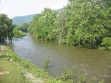
Lycoming Creek
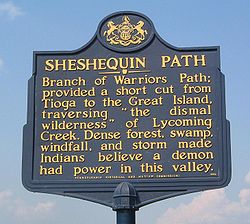
and the Sheshequin Path
played an important role in the early history of Lewis Township. The path was a major Native American
trail
in that ran between two Native American villages: "French Margaret's Town" on the West Branch Susquehanna River
(part of modern day Williamsport
in Lycoming County
) and "Sheshequin" on the North Branch of the Susquehanna River
(modern day Ulster Township
, in Bradford County
). The path ran north and east along Lycoming Creek in Lycoming County and followed much of Towanda Creek
in Bradford County. It was a shortcut between the two main branches of the Susquehanna River and was used by early settlers as well as Native Americans.
Lycoming Creek which begins to the north of Lewis Township in McNett Township also served as a highway of sorts during the colonial era of Pennsylvania's
history. The stream was used by early explorers and the Native Americans in the area as a means of travel. They were able to float their canoes down the creek and into the West Branch Susquehanna River. This mode of transportation was considerably faster than walking the path. Conrad Weiser
guided Moravian missonaries
along the creek and path to reach Onondaga
the capital of the Iroquois Confederacy in 1737. Raiding parties of Indian warriors used the creek and path in 1770 when conducting attacks on the West Branch Susquehanna Valley
strongholds of Fort Muncy and Fort Freeland. Colonel Thomas Hartley
led the 6th Pennsylvania Regiment
up the Sheshequin Path during the American Revolution
. Hartley's expedition in 1778 preceded the Sullivan Expedition
of 1779. Both Hartley and Sullivan were instrumental in claiming the frontier of Pennsylvania and New York for the forces of the Continental Army
. As Hartley and his men passed through Lewis Township the Sheshequin path was widened. The widening of the path helped to open this area to settlement in the years following the Revolution.
 Lewis Township was largely uninhabited until after the Revolutionary War. A squatter named A.M. Slack is believed to have been the first permanent settler. He built a cabin
and cleared some land in the area that is now the village of Bodines. The village of Trout Run has its beginnings during the construction of the Williamson Road. This road which stretched from Williamsport
, Pennsylvania
to Painted Post
, New York
helped to open north central Pennsylvania to settlement. Charles Williamson, the builder of the road, established a supply depot at Trout Run.
Much of Lewis Township is covered with steep slopes that were carved into the Allegheny Plateau
by the streams that drain into the West Branch Susquehanna River. The geography of the township has limited the development of the township. A narrow valley along Lycoming Creek is where most of the settlement of Lewis Township has occurred. James Kyle arrived in the area sometime around 1800. He owned 260 acres (1.1 km²) along Lycoming Creek. Kyle took out an advertisement in the Lycoming Gazette. The ad placed on March 14, 1810 read as follows.
Kyle's farm was eventually sold to Robert Allen. Robert and his family were among the most successful and prominent early settlers. Allen was born in Northumberland
on August 6, 1797. His father, John Allen, was a native of County Down
, Ireland
and his mother was from Scotland
. John Allen moved from Northumberland to a section of land along Lycoming Creek between Cogan Station and Hepburnville in Hepburn Township. He died in 1819 and his farm was divided among his children. Robert Allen sold his share of the farm to his brothers and moved further north along Lycoming Creek and bought the land that was formerly owned by James Kyle. Allen and his wife Mary Ann Hews improved the Kyle Farm. They rose to a position of prominence as the owners of an inn
that was frequently busy with visitors who were moving along the Williamson Road. Allen was also employed as a surveyor
and civil engineer
. He spent several years working for the United States Government in the Northwest Territory
especially in what is now Michigan
along the Detroit River
and Lake Huron
. Allen died in 1849 and his wife died in 1883. Her parents Henry and Martha Hews were part of the failed "English Settlement" in Pine Township
. They had migrated to Pennsylvania from Chard
, Somerset
, England. After struggling the survive in Pine Township, Henry Hews cleared and established several successful farms in Tioga County
and northern Lycoming County before finally settling near Trout Run where his daughter met and married Robert Allen.
Lewis Township has changed little over the years. The population has risen to 1,139 as of the 2000 census up from 985 in the census of 1890. Trout Run is on U.S. Route 15
which follows the old Williamson Road. This highway is currently part if the Interstate 99
project.
The Bridge in Lewis Township
was added to the National Register of Historic Places
in 1988.
, Lycoming County is about 130 miles (209 km) northwest of Philadelphia and 165 miles (266 km) east-northeast of Pittsburgh.
According to the United States Census Bureau
, the township has a total area of 37.8 square miles (98.0 km²), all of it land.
of 2000, there were 1,139 people, 451 households, and 304 families residing in the township. The population density
was 30.1 people per square mile (11.6/km²). There were 572 housing units at an average density of 15.1/sq mi (5.8/km²). The racial makeup of the township was 98.68% White, 0.35% African American, 0.09% Native American, 0.09% Asian, and 0.79% from two or more races. Hispanic or Latino of any race were 0.79% of the population.
There were 451 households out of which 29.9% had children under the age of 18 living with them, 53.0% were married couples
living together, 11.1% had a female householder with no husband present, and 32.4% were non-families. 25.1% of all households were made up of individuals and 7.5% had someone living alone who was 65 years of age or older. The average household size was 2.53 and the average family size was 3.00.
In the township the population was spread out with 24.7% under the age of 18, 7.3% from 18 to 24, 29.7% from 25 to 44, 26.4% from 45 to 64, and 11.9% who were 65 years of age or older. The median age was 38 years. For every 100 females there were 104.1 males. For every 100 females age 18 and over, there were 100.0 males.
The median income for a household in the township was $34,074, and the median income for a family was $38,661. Males had a median income of $27,989 versus $20,300 for females. The per capita income
for the township was $14,780. About 7.8% of families and 10.0% of the population were below the poverty line, including 9.2% of those under age 18 and 10.6% of those age 65 or over.
Lycoming County, Pennsylvania
-Appalachian Mountains and Allegheny Plateau:Lycoming County is divided between the Appalachian Mountains in the south, the dissected Allegheny Plateau in the north and east, and the valley of the West Branch Susquehanna River between these.-West Branch Susquehanna River:The West Branch of the...
, Pennsylvania
Pennsylvania
The Commonwealth of Pennsylvania is a U.S. state that is located in the Northeastern and Mid-Atlantic regions of the United States. The state borders Delaware and Maryland to the south, West Virginia to the southwest, Ohio to the west, New York and Ontario, Canada, to the north, and New Jersey to...
, in the United States. The population was 1,139 at the 2000 census. It is part of the Williamsport
Williamsport, Pennsylvania
Williamsport is a city in and the county seat of Lycoming County, Pennsylvania in the United States. In 2009, the population was estimated at 29,304...
, Pennsylvania Metropolitan Statistical Area.
History
Lewis Township was formed from part of Hepburn Township in 1835. It is named for Ellis Lewis who was the president judge of the local district court at the time. The township was expanded in on December 10, 1846 when part of Cascade Township was added to Lewis Township. This was done at the request of the residents of the area who geographically cut off from the rest of Cascade Township.Lycoming Creek
Lycoming Creek
Lycoming Creek is a tributary of the West Branch Susquehanna River located in Tioga and Lycoming counties in Pennsylvania in the United States.-Geography:...
and the Sheshequin Path
Sheshequin Path
The Sheshequin Path was a major Native American trail in the U.S. State of Pennsylvania that ran between two Native American villages: "French Margaret's Town" on the West Branch Susquehanna River and "Sheshequin" on the North Branch of the Susquehanna River...
played an important role in the early history of Lewis Township. The path was a major Native American
Native Americans in the United States
Native Americans in the United States are the indigenous peoples in North America within the boundaries of the present-day continental United States, parts of Alaska, and the island state of Hawaii. They are composed of numerous, distinct tribes, states, and ethnic groups, many of which survive as...
trail
Trail
A trail is a path with a rough beaten or dirt/stone surface used for travel. Trails may be for use only by walkers and in some places are the main access route to remote settlements...
in that ran between two Native American villages: "French Margaret's Town" on the West Branch Susquehanna River
West Branch Susquehanna River
The West Branch Susquehanna River is one of the two principal branches, along with the North Branch, of the Susquehanna River in the northeastern United States. The North Branch, which rises in upstate New York, is generally regarded as the extension of the main branch, with the shorter West Branch...
(part of modern day Williamsport
Williamsport, Pennsylvania
Williamsport is a city in and the county seat of Lycoming County, Pennsylvania in the United States. In 2009, the population was estimated at 29,304...
in Lycoming County
Lycoming County, Pennsylvania
-Appalachian Mountains and Allegheny Plateau:Lycoming County is divided between the Appalachian Mountains in the south, the dissected Allegheny Plateau in the north and east, and the valley of the West Branch Susquehanna River between these.-West Branch Susquehanna River:The West Branch of the...
) and "Sheshequin" on the North Branch of the Susquehanna River
Susquehanna River
The Susquehanna River is a river located in the northeastern United States. At long, it is the longest river on the American east coast that drains into the Atlantic Ocean, and with its watershed it is the 16th largest river in the United States, and the longest river in the continental United...
(modern day Ulster Township
Ulster Township, Pennsylvania
Ulster Township is a township in Bradford County, Pennsylvania, United States. The population was 1,340 at the 2000 census.It was named after the province of Ulster in Ireland.-Geography:...
, in Bradford County
Bradford County, Pennsylvania
-Demographics:As of the census of 2000, there were 62,761 people, 24,453 households, and 17,312 families residing in the county. The population density was 54 people per square mile . There were 28,664 housing units at an average density of 25 per square mile...
). The path ran north and east along Lycoming Creek in Lycoming County and followed much of Towanda Creek
Towanda Creek
thumb|right|250px|Towanda CreekTowanda Creek is a tributary of the Susquehanna River in Bradford County, Pennsylvania, in the United States.Towanda Creek rises in the southwest corner of Bradford County, south of Canton, and flows east, joining the Susquehanna River just below...
in Bradford County. It was a shortcut between the two main branches of the Susquehanna River and was used by early settlers as well as Native Americans.
Lycoming Creek which begins to the north of Lewis Township in McNett Township also served as a highway of sorts during the colonial era of Pennsylvania's
Province of Pennsylvania
The Province of Pennsylvania, also known as Pennsylvania Colony, was founded in British America by William Penn on March 4, 1681 as dictated in a royal charter granted by King Charles II...
history. The stream was used by early explorers and the Native Americans in the area as a means of travel. They were able to float their canoes down the creek and into the West Branch Susquehanna River. This mode of transportation was considerably faster than walking the path. Conrad Weiser
Conrad Weiser
Weiser's colonial service began in 1731. The Iroquois sent Shikellamy, an Oneida chief, as an emissary to other tribes and the British. Shikellamy lived on the Susquehanna River at Shamokin village, near present-day Sunbury, Pennsylvania. An oral tradition holds that Weiser met Shikellamy while...
guided Moravian missonaries
Missionary
A missionary is a member of a religious group sent into an area to do evangelism or ministries of service, such as education, literacy, social justice, health care and economic development. The word "mission" originates from 1598 when the Jesuits sent members abroad, derived from the Latin...
along the creek and path to reach Onondaga
Onondaga, New York
Onondaga is a town located in Onondaga County, New York, United States. As of the 2000 U.S. Census, the town had a population of 21,063. The town is named after the native Onondaga tribe, part of the Iroquois Confederacy....
the capital of the Iroquois Confederacy in 1737. Raiding parties of Indian warriors used the creek and path in 1770 when conducting attacks on the West Branch Susquehanna Valley
West Branch Susquehanna Valley
The West Branch Susquehanna Valley of central Pennsylvania, United States, in the Ridge-and-valley Appalachians, is the low lying area draining into the West Branch Susquehanna River southeast of the Allegheny Front, northeast of the Bald Eagle Valley, southwest of the Wyoming Valley and nort of...
strongholds of Fort Muncy and Fort Freeland. Colonel Thomas Hartley
Thomas Hartley
Thomas Hartley was an American lawyer, soldier, and politician from York, Pennsylvania.He was born in Reading, Pennsylvania and practiced law in York...
led the 6th Pennsylvania Regiment
6th Pennsylvania Regiment
The 6th Pennsylvania Regiment was a unit of the United States of America Army, raised December 9, 1775 at Philadelphia, Pennsylvania for service with the Continental Army. The regiment would see action during the New York Campaign, Battle of Brandywine, Battle of Germantown, Battle of Monmouth and...
up the Sheshequin Path during the American Revolution
American Revolution
The American Revolution was the political upheaval during the last half of the 18th century in which thirteen colonies in North America joined together to break free from the British Empire, combining to become the United States of America...
. Hartley's expedition in 1778 preceded the Sullivan Expedition
Sullivan Expedition
The Sullivan Expedition, also known as the Sullivan-Clinton Expedition, was an American campaign led by Major General John Sullivan and Brigadier General James Clinton against Loyalists and the four nations of the Iroquois who had sided with the British in the American Revolutionary War.The...
of 1779. Both Hartley and Sullivan were instrumental in claiming the frontier of Pennsylvania and New York for the forces of the Continental Army
Continental Army
The Continental Army was formed after the outbreak of the American Revolutionary War by the colonies that became the United States of America. Established by a resolution of the Continental Congress on June 14, 1775, it was created to coordinate the military efforts of the Thirteen Colonies in...
. As Hartley and his men passed through Lewis Township the Sheshequin path was widened. The widening of the path helped to open this area to settlement in the years following the Revolution.
Log cabin
A log cabin is a house built from logs. It is a fairly simple type of log house. A distinction should be drawn between the traditional meanings of "log cabin" and "log house." Historically most "Log cabins" were a simple one- or 1½-story structures, somewhat impermanent, and less finished or less...
and cleared some land in the area that is now the village of Bodines. The village of Trout Run has its beginnings during the construction of the Williamson Road. This road which stretched from Williamsport
Williamsport, Pennsylvania
Williamsport is a city in and the county seat of Lycoming County, Pennsylvania in the United States. In 2009, the population was estimated at 29,304...
, Pennsylvania
Pennsylvania
The Commonwealth of Pennsylvania is a U.S. state that is located in the Northeastern and Mid-Atlantic regions of the United States. The state borders Delaware and Maryland to the south, West Virginia to the southwest, Ohio to the west, New York and Ontario, Canada, to the north, and New Jersey to...
to Painted Post
Painted Post, New York
Painted Post is a village in Steuben County, New York, United States. The village is in the town of Erwin, west of the city of Corning. The population was 1,842 at the 2000 census. The name comes from a painted and carved post found by explorers at the junction of three local rivers...
, New York
New York
New York is a state in the Northeastern region of the United States. It is the nation's third most populous state. New York is bordered by New Jersey and Pennsylvania to the south, and by Connecticut, Massachusetts and Vermont to the east...
helped to open north central Pennsylvania to settlement. Charles Williamson, the builder of the road, established a supply depot at Trout Run.
Much of Lewis Township is covered with steep slopes that were carved into the Allegheny Plateau
Allegheny Plateau
The Allegheny Plateau is a large dissected plateau area in western and central New York, northern and western Pennsylvania, northern and western West Virginia, and eastern Ohio...
by the streams that drain into the West Branch Susquehanna River. The geography of the township has limited the development of the township. A narrow valley along Lycoming Creek is where most of the settlement of Lewis Township has occurred. James Kyle arrived in the area sometime around 1800. He owned 260 acres (1.1 km²) along Lycoming Creek. Kyle took out an advertisement in the Lycoming Gazette. The ad placed on March 14, 1810 read as follows.
Kyle's farm was eventually sold to Robert Allen. Robert and his family were among the most successful and prominent early settlers. Allen was born in Northumberland
Northumberland, Pennsylvania
Northumberland is a borough in Northumberland County, Pennsylvania, United States. The population was 3,714 at the 2000 census.-History:Northumberland was founded in 1772. The land that became Northumberland was purchased from the Iroquois in the first Treaty of Fort Stanwix in 1768, and the...
on August 6, 1797. His father, John Allen, was a native of County Down
County Down
-Cities:*Belfast *Newry -Large towns:*Dundonald*Newtownards*Bangor-Medium towns:...
, Ireland
Ireland
Ireland is an island to the northwest of continental Europe. It is the third-largest island in Europe and the twentieth-largest island on Earth...
and his mother was from Scotland
Scotland
Scotland is a country that is part of the United Kingdom. Occupying the northern third of the island of Great Britain, it shares a border with England to the south and is bounded by the North Sea to the east, the Atlantic Ocean to the north and west, and the North Channel and Irish Sea to the...
. John Allen moved from Northumberland to a section of land along Lycoming Creek between Cogan Station and Hepburnville in Hepburn Township. He died in 1819 and his farm was divided among his children. Robert Allen sold his share of the farm to his brothers and moved further north along Lycoming Creek and bought the land that was formerly owned by James Kyle. Allen and his wife Mary Ann Hews improved the Kyle Farm. They rose to a position of prominence as the owners of an inn
INN
InterNetNews is a Usenet news server package, originally released by Rich Salz in 1991, and presented at the Summer 1992 USENIX conference in San Antonio, Texas...
that was frequently busy with visitors who were moving along the Williamson Road. Allen was also employed as a surveyor
Surveying
See Also: Public Land Survey SystemSurveying or land surveying is the technique, profession, and science of accurately determining the terrestrial or three-dimensional position of points and the distances and angles between them...
and civil engineer
Civil engineer
A civil engineer is a person who practices civil engineering; the application of planning, designing, constructing, maintaining, and operating infrastructures while protecting the public and environmental health, as well as improving existing infrastructures that have been neglected.Originally, a...
. He spent several years working for the United States Government in the Northwest Territory
Northwest Territory
The Territory Northwest of the River Ohio, more commonly known as the Northwest Territory, was an organized incorporated territory of the United States that existed from July 13, 1787, until March 1, 1803, when the southeastern portion of the territory was admitted to the Union as the state of Ohio...
especially in what is now Michigan
Michigan
Michigan is a U.S. state located in the Great Lakes Region of the United States of America. The name Michigan is the French form of the Ojibwa word mishigamaa, meaning "large water" or "large lake"....
along the Detroit River
Detroit River
The Detroit River is a strait in the Great Lakes system. The name comes from the French Rivière du Détroit, which translates literally as "River of the Strait". The Detroit River has served an important role in the history of Detroit and is one of the busiest waterways in the world. The river...
and Lake Huron
Lake Huron
Lake Huron is one of the five Great Lakes of North America. Hydrologically, it comprises the larger portion of Lake Michigan-Huron. It is bounded on the east by the Canadian province of Ontario and on the west by the state of Michigan in the United States...
. Allen died in 1849 and his wife died in 1883. Her parents Henry and Martha Hews were part of the failed "English Settlement" in Pine Township
Pine Township, Lycoming County, Pennsylvania
Pine Township is a township in Lycoming County, Pennsylvania, in the United States. The population was 329 at the 2000 census. It is part of the Williamsport, Pennsylvania Metropolitan Statistical Area.-History:...
. They had migrated to Pennsylvania from Chard
Chard, Somerset
Chard is a town and civil parish in the Somerset county of England. It lies on the A30 road near the Devon border, south west of Yeovil. The parish has a population of approximately 12,000 and, at an elevation of , it is the southernmost and highest town in Somerset...
, Somerset
Somerset
The ceremonial and non-metropolitan county of Somerset in South West England borders Bristol and Gloucestershire to the north, Wiltshire to the east, Dorset to the south-east, and Devon to the south-west. It is partly bounded to the north and west by the Bristol Channel and the estuary of the...
, England. After struggling the survive in Pine Township, Henry Hews cleared and established several successful farms in Tioga County
Tioga County, Pennsylvania
Tioga County is a county located in the U.S. state of Pennsylvania. As of the 2010 census, the population was 41,981. Tioga County was created on March 26, 1804, from part of Lycoming County and named for the Tioga River. Its county seat is Wellsboro....
and northern Lycoming County before finally settling near Trout Run where his daughter met and married Robert Allen.
Lewis Township has changed little over the years. The population has risen to 1,139 as of the 2000 census up from 985 in the census of 1890. Trout Run is on U.S. Route 15
U.S. Route 15
U.S. Route 15 is a -long United States highway, designated along South Carolina, North Carolina, Virginia, Maryland, Pennsylvania, and New York. The route is signed north–south, from U.S. Route 17 Alternate in Walterboro, South Carolina to Interstate 86 and NY 17 in Painted Post, New York.US...
which follows the old Williamson Road. This highway is currently part if the Interstate 99
Interstate 99
Interstate 99 is an intrastate Interstate Highway located in central Pennsylvania in the United States. The southern terminus of the route is at exit 146 of the Pennsylvania Turnpike north of Bedford, where the road continues south as U.S. Route 220 . The northern terminus is at...
project.
The Bridge in Lewis Township
Bridge in Lewis Township
Bridge in Lewis Township is a historic Pratt through truss bridge spanning Lycoming Creek at Lewis Township, Lycoming County, Pennsylvania. It was built in 1890, and measures 171 feet long and 18 feet wide....
was added to the National Register of Historic Places
National Register of Historic Places
The National Register of Historic Places is the United States government's official list of districts, sites, buildings, structures, and objects deemed worthy of preservation...
in 1988.
Geography
Lewis Township is bordered by Cogan House Township to the west, McIntyre Township to the north, Cascade Township to the east, Gamble Township to the southeast, Hepburn Township borders at the extreme southeast corner of Lewis Township, and by Lycoming Township to the south. As the crow fliesAs the crow flies
"As the crow flies" or beelining is an idiom for the shortest route between two points; the geodesic distance.An example is the great-circle distance between Key West and Pensacola, at either end of the U.S...
, Lycoming County is about 130 miles (209 km) northwest of Philadelphia and 165 miles (266 km) east-northeast of Pittsburgh.
According to the United States Census Bureau
United States Census Bureau
The United States Census Bureau is the government agency that is responsible for the United States Census. It also gathers other national demographic and economic data...
, the township has a total area of 37.8 square miles (98.0 km²), all of it land.
Demographics
As of the censusCensus
A census is the procedure of systematically acquiring and recording information about the members of a given population. It is a regularly occurring and official count of a particular population. The term is used mostly in connection with national population and housing censuses; other common...
of 2000, there were 1,139 people, 451 households, and 304 families residing in the township. The population density
Population density
Population density is a measurement of population per unit area or unit volume. It is frequently applied to living organisms, and particularly to humans...
was 30.1 people per square mile (11.6/km²). There were 572 housing units at an average density of 15.1/sq mi (5.8/km²). The racial makeup of the township was 98.68% White, 0.35% African American, 0.09% Native American, 0.09% Asian, and 0.79% from two or more races. Hispanic or Latino of any race were 0.79% of the population.
There were 451 households out of which 29.9% had children under the age of 18 living with them, 53.0% were married couples
Marriage
Marriage is a social union or legal contract between people that creates kinship. It is an institution in which interpersonal relationships, usually intimate and sexual, are acknowledged in a variety of ways, depending on the culture or subculture in which it is found...
living together, 11.1% had a female householder with no husband present, and 32.4% were non-families. 25.1% of all households were made up of individuals and 7.5% had someone living alone who was 65 years of age or older. The average household size was 2.53 and the average family size was 3.00.
In the township the population was spread out with 24.7% under the age of 18, 7.3% from 18 to 24, 29.7% from 25 to 44, 26.4% from 45 to 64, and 11.9% who were 65 years of age or older. The median age was 38 years. For every 100 females there were 104.1 males. For every 100 females age 18 and over, there were 100.0 males.
The median income for a household in the township was $34,074, and the median income for a family was $38,661. Males had a median income of $27,989 versus $20,300 for females. The per capita income
Per capita income
Per capita income or income per person is a measure of mean income within an economic aggregate, such as a country or city. It is calculated by taking a measure of all sources of income in the aggregate and dividing it by the total population...
for the township was $14,780. About 7.8% of families and 10.0% of the population were below the poverty line, including 9.2% of those under age 18 and 10.6% of those age 65 or over.
See also
For histories of the other townships in Lycoming County see- History of the Townships of Lycoming County, PennsylvaniaHistory of the Townships of Lycoming County, PennsylvaniaLycoming County was formed from Northumberland County on April 13, 1795. At the time it was formed the county was much larger than it is today. It took up most of the land that is now north central Pennsylvania....