

Snowville, Utah
Encyclopedia
Snowville is a town in Box Elder County
, Utah
, United States
. The population was 167 at the 2010 census.
According to the United States Census Bureau
, the town has a total area of 1.5 square miles (4.0 km²), all land.
of 2000, there were 177 people, 59 households, and 46 families residing in the town. The population density
was 115.4 people per square mile (44.7/km²). There were 71 housing units at an average density of 46.3 per square mile (17.9/km²). The racial makeup of the town was 88.70% White, 0.56% Asian, 9.60% from other races
, and 1.13% from two or more races. Hispanic or Latino of any race were 19.21% of the population.
There were 59 households out of which 47.5% had children under the age of 18 living with them, 62.7% were married couples
living together, 10.2% had a female householder with no husband present, and 22.0% were non-families. 20.3% of all households were made up of individuals and 10.2% had someone living alone who was 65 years of age or older. The average household size was 3.00 and the average family size was 3.52.
In the town the population was spread out with 29.9% under the age of 18, 15.3% from 18 to 24, 24.3% from 25 to 44, 20.3% from 45 to 64, and 10.2% who were 65 years of age or older. The median age was 28 years. For every 100 females there were 96.7 males. For every 100 females age 18 and over, there were 96.8 males.
The median income for a household in the town was $24,375, and the median income for a family was $35,750. Males had a median income of $36,250 versus $35,250 for females. The per capita income
for the town was $13,604. None of the families and 4.8% of the population were living below the poverty line, including no under eighteens and 54.5% of those over 64.
 Curlew Valley, named after the curlew
snipe
that nests there, extends from Snowville, Utah, to the Idaho towns of Stone and Holbrook. The first recorded white men were Peter Skene Ogden
's large party of trappers that camped on Deep Creek December 27, 1828.
Some of the discharged members of the Mormon Battalion
, on their way home from California
to Salt Lake City on September 18, 1848, camped on Deep Creek and also in a cave one mile (1.6 km) east called Hollow Rock.
The beginning of Deep Creek is a large spring at Holbrook which runs through the center of the valley and has never varied even in dry years. About one mile (1.6 km) southwest is Rocky Ford, where the pioneers were able to pass on solid rock.
In 1869 William Robbins, Thomas Showell, and William M. Harris settled at the Curlew Sinks, ten miles (16 km) west of here, where Deep Creek sinks into the ground. The old pioneer trail and the stage line went through their ranch.
The first townsite in the Curlew Valley was Snowville. Settled at the direction of Brigham Young
and named in honor of Lorenzo Snow
an apostle at the time but later to become the President of The Church of Jesus Christ of Latter-day Saints 1898–1901. Snowville was laid out August 14, 1878.
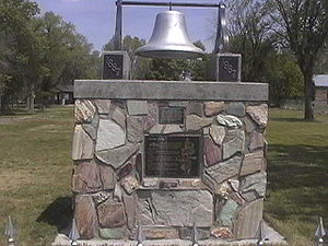
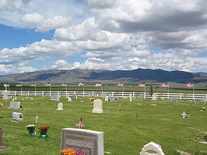 The Snowville Cemetery is located at 750 North 600 West in Snowville, Utah. The earliest burial is that of William O'Donald who died May 27, 1869. As of 2004 there are 540 burials on 10 acres (40,468.6 m²) owned by the town of Snowville. Two unknown soldiers are buried in the cemetery as well as William Robbins, the first settler of the valley and a veteran of the American Civil War
. The cemetery has a searchable database available by the Utah History Research Center.
Box Elder County, Utah
Box Elder County is a county located in the U.S. state of Utah. It lies on the north end of the Great Salt Lake, covering a large area north to the Idaho border and west to the Nevada border. Included in this area are large tracts of barren desert, contrasted by high, forested mountains. The...
, Utah
Utah
Utah is a state in the Western United States. It was the 45th state to join the Union, on January 4, 1896. Approximately 80% of Utah's 2,763,885 people live along the Wasatch Front, centering on Salt Lake City. This leaves vast expanses of the state nearly uninhabited, making the population the...
, United States
United States
The United States of America is a federal constitutional republic comprising fifty states and a federal district...
. The population was 167 at the 2010 census.
Geography
Snowville is located at 41°58′14"N 112°42′33"W (41.970690, -112.709099), at 4551 feet (1,387.1 m) in elevation.According to the United States Census Bureau
United States Census Bureau
The United States Census Bureau is the government agency that is responsible for the United States Census. It also gathers other national demographic and economic data...
, the town has a total area of 1.5 square miles (4.0 km²), all land.
Demographics
As of the censusCensus
A census is the procedure of systematically acquiring and recording information about the members of a given population. It is a regularly occurring and official count of a particular population. The term is used mostly in connection with national population and housing censuses; other common...
of 2000, there were 177 people, 59 households, and 46 families residing in the town. The population density
Population density
Population density is a measurement of population per unit area or unit volume. It is frequently applied to living organisms, and particularly to humans...
was 115.4 people per square mile (44.7/km²). There were 71 housing units at an average density of 46.3 per square mile (17.9/km²). The racial makeup of the town was 88.70% White, 0.56% Asian, 9.60% from other races
Race (United States Census)
Race and ethnicity in the United States Census, as defined by the Federal Office of Management and Budget and the United States Census Bureau, are self-identification data items in which residents choose the race or races with which they most closely identify, and indicate whether or not they are...
, and 1.13% from two or more races. Hispanic or Latino of any race were 19.21% of the population.
There were 59 households out of which 47.5% had children under the age of 18 living with them, 62.7% were married couples
Marriage
Marriage is a social union or legal contract between people that creates kinship. It is an institution in which interpersonal relationships, usually intimate and sexual, are acknowledged in a variety of ways, depending on the culture or subculture in which it is found...
living together, 10.2% had a female householder with no husband present, and 22.0% were non-families. 20.3% of all households were made up of individuals and 10.2% had someone living alone who was 65 years of age or older. The average household size was 3.00 and the average family size was 3.52.
In the town the population was spread out with 29.9% under the age of 18, 15.3% from 18 to 24, 24.3% from 25 to 44, 20.3% from 45 to 64, and 10.2% who were 65 years of age or older. The median age was 28 years. For every 100 females there were 96.7 males. For every 100 females age 18 and over, there were 96.8 males.
The median income for a household in the town was $24,375, and the median income for a family was $35,750. Males had a median income of $36,250 versus $35,250 for females. The per capita income
Per capita income
Per capita income or income per person is a measure of mean income within an economic aggregate, such as a country or city. It is calculated by taking a measure of all sources of income in the aggregate and dividing it by the total population...
for the town was $13,604. None of the families and 4.8% of the population were living below the poverty line, including no under eighteens and 54.5% of those over 64.
History
Curlew
The curlews , genus Numenius, are a group of eight species of birds, characterised by long, slender, downcurved bills and mottled brown plumage. They are one of the most ancient lineages of scolopacid waders, together with the godwits which look similar but have straight bills...
snipe
Snipe
A snipe is any of about 25 wading bird species in three genera in the family Scolopacidae. They are characterized by a very long, slender bill and crypsis plumage. The Gallinago snipes have a nearly worldwide distribution, the Lymnocryptes Jack Snipe is restricted to Asia and Europe and the...
that nests there, extends from Snowville, Utah, to the Idaho towns of Stone and Holbrook. The first recorded white men were Peter Skene Ogden
Peter Skene Ogden
Peter Skene Ogden , was a fur trader and a Canadian explorer of what is now British Columbia and the American West...
's large party of trappers that camped on Deep Creek December 27, 1828.
Some of the discharged members of the Mormon Battalion
Mormon Battalion
The Mormon Battalion was the only religiously based unit in United States military history, and it served from July 1846 to July 1847 during the Mexican-American War. The battalion was a volunteer unit of between 534 and 559 Latter-day Saints men led by Mormon company officers, commanded by regular...
, on their way home from California
California
California is a state located on the West Coast of the United States. It is by far the most populous U.S. state, and the third-largest by land area...
to Salt Lake City on September 18, 1848, camped on Deep Creek and also in a cave one mile (1.6 km) east called Hollow Rock.
The beginning of Deep Creek is a large spring at Holbrook which runs through the center of the valley and has never varied even in dry years. About one mile (1.6 km) southwest is Rocky Ford, where the pioneers were able to pass on solid rock.
In 1869 William Robbins, Thomas Showell, and William M. Harris settled at the Curlew Sinks, ten miles (16 km) west of here, where Deep Creek sinks into the ground. The old pioneer trail and the stage line went through their ranch.
The first townsite in the Curlew Valley was Snowville. Settled at the direction of Brigham Young
Brigham Young
Brigham Young was an American leader in the Latter Day Saint movement and a settler of the Western United States. He was the President of The Church of Jesus Christ of Latter-day Saints from 1847 until his death in 1877, he founded Salt Lake City, and he served as the first governor of the Utah...
and named in honor of Lorenzo Snow
Lorenzo Snow
Lorenzo Snow was the fifth president of The Church of Jesus Christ of Latter-day Saints from 1898 to his death. Snow was the last president of the LDS Church in the nineteenth century.-Family:...
an apostle at the time but later to become the President of The Church of Jesus Christ of Latter-day Saints 1898–1901. Snowville was laid out August 14, 1878.
Cemetery
American Civil War
The American Civil War was a civil war fought in the United States of America. In response to the election of Abraham Lincoln as President of the United States, 11 southern slave states declared their secession from the United States and formed the Confederate States of America ; the other 25...
. The cemetery has a searchable database available by the Utah History Research Center.