
Interstate 84 in Utah
Encyclopedia
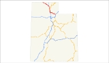
In the U.S. state
of Utah
, Interstate 84
heads southeast from the Idaho
state line, overlapping Interstate 15
between Tremonton
and Ogden
and ending at Interstate 80
at Echo
.
-Utah border approximately 7 miles (11.3 km) from Snowville, Utah
, in the Curlew Valley, located in northern Box Elder County
. The road heads in a generally southeasterly direction, intersecting SR-30
which provides access to the far northwestern corner of Utah, before crossing Deep Creek and passing through Snowville. I-84 passes just north of the Hansel Mountains before crossing the North Promontory Mountains
and dropping into the Blue Creek Valley and the town of Howell
. I-84 intersects two more local roads before crossing West Canal, and entering Tremonton
. SR-102
intersects I-84 before an interchange with I-15
, becoming concurrent with I-15.
(UP) lines on the east as well as the Wellville Mountain Wilderness, and approaching an interchange with US-91
which provides access to Logan
. After Logan, I-84 borders the Weber-Box Elder Canal and Wasatch-Cache National Forrest on the east, and on the west the Willard Bay Reservoir
before exiting the county, and entering Weber County
. I-84 enters Weber County , where the UP lines split from I-15/I-84 in Pleasant View
, and continues southward towards the Ogden Municipal Airport and its split from I-15 near Roy.
, I-84 enters Weber County
before briefly entering Davis County
, and returning to Weber County. It passes by Hill Air Force Base
as it starts to follow the Weber River
into Morgan County
and the Wasatch-Cache National Forest. Visible in Weber Canyon
is Devil's Slide
, an unusual rock formation just off the freeway. Entering Summit County
, farther up the canyon is the Thousand Mile Tree
, planted by Union Pacific Railroad
workers to mark 1000 miles (1,609.3 km) from the railroad's origin in Omaha, Nebraska
. The freeway ends at Echo
, a near ghost town that before served as a stopover for the railroad, at a junction with I-80
. Also south of the I-80 junction is Echo Reservoir and Echo Dam.
and the First Transcontinental Railroad
U.S. state
A U.S. state is any one of the 50 federated states of the United States of America that share sovereignty with the federal government. Because of this shared sovereignty, an American is a citizen both of the federal entity and of his or her state of domicile. Four states use the official title of...
of Utah
Utah
Utah is a state in the Western United States. It was the 45th state to join the Union, on January 4, 1896. Approximately 80% of Utah's 2,763,885 people live along the Wasatch Front, centering on Salt Lake City. This leaves vast expanses of the state nearly uninhabited, making the population the...
, Interstate 84
Interstate 84 (west)
Interstate 84 is an Interstate Highway in the Western United States that runs from Portland, Oregon, to a junction with Interstate 80 near Echo, Utah. The highway originally served as a fork of I-80 to serve the Pacific Northwest, and was originally numbered Interstate 80N.The highway serves and...
heads southeast from the Idaho
Idaho
Idaho is a state in the Rocky Mountain area of the United States. The state's largest city and capital is Boise. Residents are called "Idahoans". Idaho was admitted to the Union on July 3, 1890, as the 43rd state....
state line, overlapping Interstate 15
Interstate 15 in Utah
In the U.S. state of Utah, Interstate 15 runs north–south through the southwestern and central portions of the state, passing through many of the population centers of that state, including St. George, Provo, Salt Lake City, and Ogden, the latter three being part of the urban area known as...
between Tremonton
Tremonton, Utah
Tremonton is a city in Box Elder County, Utah, United States. The population was 7,647 at the 2010 census.-Geography:Tremonton is located at ....
and Ogden
Ogden, Utah
Ogden is a city in Weber County, Utah, United States. Ogden serves as the county seat of Weber County. The population was 82,825 according to the 2010 Census. The city served as a major railway hub through much of its history, and still handles a great deal of freight rail traffic which makes it a...
and ending at Interstate 80
Interstate 80 in Utah
In the U.S. state of Utah, Interstate 80 runs east–west through northern part of the state, passing through the Bonneville Salt Flats, the Salt Lake City metropolitan area, the Wasatch Mountains and Echo canyon. In western Utah the highway was built along the corridor of the Victory...
at Echo
Echo, Utah
Echo is a census-designated place located in Summit County, Utah, United States. The population was 56 at the 2010 census. Although Echo has never had a sizable population, the town is historically significant.-History:...
.
Western segment
I-84 crosses the IdahoIdaho
Idaho is a state in the Rocky Mountain area of the United States. The state's largest city and capital is Boise. Residents are called "Idahoans". Idaho was admitted to the Union on July 3, 1890, as the 43rd state....
-Utah border approximately 7 miles (11.3 km) from Snowville, Utah
Snowville, Utah
Snowville is a town in Box Elder County, Utah, United States. The population was 167 at the 2010 census.-Geography:Snowville is located at , at in elevation....
, in the Curlew Valley, located in northern Box Elder County
Box Elder County, Utah
Box Elder County is a county located in the U.S. state of Utah. It lies on the north end of the Great Salt Lake, covering a large area north to the Idaho border and west to the Nevada border. Included in this area are large tracts of barren desert, contrasted by high, forested mountains. The...
. The road heads in a generally southeasterly direction, intersecting SR-30
Utah State Route 30
State Route 30 is a state highway in the U.S. state of Utah. It is the only highway signed as a Utah state route to traverse the entire width of the state. Legislatively the highway exists as 3 separate segments. The three sections are easily connectable via Interstate 84 and U.S. Route 89...
which provides access to the far northwestern corner of Utah, before crossing Deep Creek and passing through Snowville. I-84 passes just north of the Hansel Mountains before crossing the North Promontory Mountains
Promontory Mountains
The Promontory Mountains are a range in Box Elder County, Utah. The range is oriented north-south and has a length of about . The southern portion forms a cape extending south into the Great Salt Lake...
and dropping into the Blue Creek Valley and the town of Howell
Howell, Utah
Howell is a town in Box Elder County, Utah, United States. The population was 245 at the 2010 census.-Geography:Howell is located at ....
. I-84 intersects two more local roads before crossing West Canal, and entering Tremonton
Tremonton, Utah
Tremonton is a city in Box Elder County, Utah, United States. The population was 7,647 at the 2010 census.-Geography:Tremonton is located at ....
. SR-102
Utah State Route 102
State Route 102 is a state highway in the U.S. state of Utah that connects Tremonton with I-84, SR-83, and the towns of Deweyville, Bothwell, Thatcher, Penrose, and Thiokol's facility in Box Elder County.-Route description:...
intersects I-84 before an interchange with I-15
Interstate 15 in Utah
In the U.S. state of Utah, Interstate 15 runs north–south through the southwestern and central portions of the state, passing through many of the population centers of that state, including St. George, Provo, Salt Lake City, and Ogden, the latter three being part of the urban area known as...
, becoming concurrent with I-15.
Concurrency with I-15
I-15/I-84 continues southward, paralleling Union Pacific RailroadUnion Pacific Railroad
The Union Pacific Railroad , headquartered in Omaha, Nebraska, is the largest railroad network in the United States. James R. Young is president, CEO and Chairman....
(UP) lines on the east as well as the Wellville Mountain Wilderness, and approaching an interchange with US-91
U.S. Route 91
U.S. Route 91 is a north–south United States highway. The highway currently serves as a connection between the Cache Valley area of Utah and Idaho to the Salt Lake and Idaho Falls population centers. Prior the mid-1970s, U.S. 91 was an international commerce route from Long Beach, California...
which provides access to Logan
Logan, Utah
-Layout of the City:Logan's city grid originates from its Main and Center Street block, with Main Street running north and south, and Center east and west. Each block north, east, south, or west of the origin accumulates in additions of 100 , though some streets have non-numeric names...
. After Logan, I-84 borders the Weber-Box Elder Canal and Wasatch-Cache National Forrest on the east, and on the west the Willard Bay Reservoir
Willard Bay
Willard Bay is a reservoir in Northern Utah.- Geography :Willard Bay is a freshwater reservoir located in eastern Box Elder County, Utah, north-west of the city of Ogden, on the north-eastern floodplains of the Great Salt Lake. The reservoir is operated by the Weber Basin Water Conservancy...
before exiting the county, and entering Weber County
Weber County, Utah
Weber County is a county located in the U.S. state of Utah, occupying a stretch of the Wasatch Front, part of the eastern shores of Great Salt Lake, and much of the rugged Wasatch Mountains. As of the 2000 census, the population was 196,533, an increase of 24.1% over its population in 1990. By...
. I-84 enters Weber County , where the UP lines split from I-15/I-84 in Pleasant View
Pleasant View, Utah
Pleasant View is a city in Weber County, Utah, United States. The population was 5,632 at the 2000 census. It is part of the Ogden–Clearfield, Utah Metropolitan Statistical Area...
, and continues southward towards the Ogden Municipal Airport and its split from I-15 near Roy.
Eastern segment
Splitting from I-15 near RoyRoy, Utah
-Demographics:As of the census of 2010, there were 36,884 people, 10,689 households, and 8,604 families residing in the city. The population density was 4,853 people per square mile . There were 11,053 housing units at an average density of 1,455.3 per square mile...
, I-84 enters Weber County
Weber County, Utah
Weber County is a county located in the U.S. state of Utah, occupying a stretch of the Wasatch Front, part of the eastern shores of Great Salt Lake, and much of the rugged Wasatch Mountains. As of the 2000 census, the population was 196,533, an increase of 24.1% over its population in 1990. By...
before briefly entering Davis County
Davis County, Utah
Davis County is a county located in the U.S. state of Utah. As of 2010 the population was 306,479, a 28.2% increase over the 2000 figure of 238,994. It was named for Daniel C. Davis, captain in the Mormon Battalion. The county is part of the Ogden–Clearfield Metropolitan Statistical Area as...
, and returning to Weber County. It passes by Hill Air Force Base
Hill Air Force Base
Hill Air Force Base is a major U.S. Air Force Base located in northern Utah, just south of the city of Ogden, and near the towns of Clearfield, Riverdale, Roy, Sunset, and Layton. It is about north of Salt Lake City. The base was named in honor of Major Ployer Peter Hill of the U.S. Army Air...
as it starts to follow the Weber River
Weber River
The Weber River is a c. long river of northern Utah, USA. It begins in the northwest of the Uinta Mountains and empties into the Great Salt Lake. The Weber River was named for American fur trapper John Henry Weber.-Weber River:...
into Morgan County
Morgan County, Utah
Morgan County is a county located in the U.S. state of Utah. As of 2010 the population was 9,469. It was named for Jedediah Morgan Grant, father of Heber J. Grant, who served as president of the Church of Jesus Christ of Latter-day Saints...
and the Wasatch-Cache National Forest. Visible in Weber Canyon
Weber Canyon
Weber Canyon is a canyon in the Wasatch Range near Ogden, Utah, through which the Weber River flows west toward the Great Salt Lake. It is fed by 13 tributary creeks and is 40 miles long.- History :...
is Devil's Slide
Devil's Slide (Utah)
Devil's Slide is an unusual geological formation located in northern Utah's Weber Canyon, near the community of Croydon in Morgan County, Utah, United States. The slide consists of two parallel limestone strata that have been tilted to lie vertical, protruding out of the mountainside...
, an unusual rock formation just off the freeway. Entering Summit County
Summit County, Utah
Summit County is a county located in the U.S. state of Utah, occupying a rugged and mountainous area. In 2010 its population was 36,324. It is part of the Salt Lake City Metropolitan Statistical Area as well as the Salt Lake City–Ogden–Clearfield Combined Statistical Area. The county is...
, farther up the canyon is the Thousand Mile Tree
Thousand Mile Tree
Thousand Mile Tree is a pine tree located in Weber Canyon near the community of Henefer, Utah, along the Overland Route of the Union Pacific Railroad...
, planted by Union Pacific Railroad
Union Pacific Railroad
The Union Pacific Railroad , headquartered in Omaha, Nebraska, is the largest railroad network in the United States. James R. Young is president, CEO and Chairman....
workers to mark 1000 miles (1,609.3 km) from the railroad's origin in Omaha, Nebraska
Omaha, Nebraska
Omaha is the largest city in the state of Nebraska, United States, and is the county seat of Douglas County. It is located in the Midwestern United States on the Missouri River, about 20 miles north of the mouth of the Platte River...
. The freeway ends at Echo
Echo, Utah
Echo is a census-designated place located in Summit County, Utah, United States. The population was 56 at the 2010 census. Although Echo has never had a sizable population, the town is historically significant.-History:...
, a near ghost town that before served as a stopover for the railroad, at a junction with I-80
Interstate 80 in Utah
In the U.S. state of Utah, Interstate 80 runs east–west through northern part of the state, passing through the Bonneville Salt Flats, the Salt Lake City metropolitan area, the Wasatch Mountains and Echo canyon. In western Utah the highway was built along the corridor of the Victory...
. Also south of the I-80 junction is Echo Reservoir and Echo Dam.
History
Interstate 84 in Utah replaced the former route of U.S. Route 30S. The highway loosely follows the path of the Oregon TrailOregon Trail
The Oregon Trail is a historic east-west wagon route that connected the Missouri River to valleys in Oregon and locations in between.After 1840 steam-powered riverboats and steamboats traversing up and down the Ohio, Mississippi and Missouri rivers sped settlement and development in the flat...
and the First Transcontinental Railroad
First Transcontinental Railroad
The First Transcontinental Railroad was a railroad line built in the United States of America between 1863 and 1869 by the Central Pacific Railroad of California and the Union Pacific Railroad that connected its statutory Eastern terminus at Council Bluffs, Iowa/Omaha, Nebraska The First...
- 30S was one of the original routes in '26.
- I-80N renamed.
- Legislative designaion was SR-3.
- Deleted May 20, 1977
- AASHTO approved name change from 80N > 84 on July 7, 1977
Exit list
| County | Location | Mile | # Exit number An exit number is a number assigned to a road junction, usually an exit from a freeway. It is usually marked on the same sign as the destinations of the exit, as well as a sign in the gore.... |
Destinations | Notes |
|---|---|---|---|---|---|
| Box Elder Box Elder County, Utah Box Elder County is a county located in the U.S. state of Utah. It lies on the north end of the Great Salt Lake, covering a large area north to the Idaho border and west to the Nevada border. Included in this area are large tracts of barren desert, contrasted by high, forested mountains. The... |
4.660 | 5 | , Elko Elko, Nevada Elko is a city in Elko County, Nevada, United States. The population was 18,297 at the 2010 census. It is the county seat of Elko County. The city straddles the Humboldt River.... |
West end of SR-30 overlap | |
| Snowville Snowville, Utah Snowville is a town in Box Elder County, Utah, United States. The population was 167 at the 2010 census.-Geography:Snowville is located at , at in elevation.... |
7.125 | 7 | Snowville Snowville, Utah Snowville is a town in Box Elder County, Utah, United States. The population was 167 at the 2010 census.-Geography:Snowville is located at , at in elevation.... |
||
| 11.978 | 12 | Ranch Exit | |||
| 15.808 | 16 | Ranch Exit | |||
| 17.385 | 17 | Ranch Exit | |||
| 20.317 | 20 | Blue Creek Blue Creek, Utah Blue Creek is a ghost town in Box Elder County, Utah, United States. It was a railroad settlement that started as a Union Pacific camp during the final stages of construction of the First Transcontinental Railroad.... |
|||
| 24.457 | 24 | Valley | |||
| Howell Howell, Utah Howell is a town in Box Elder County, Utah, United States. The population was 245 at the 2010 census.-Geography:Howell is located at .... |
26.567 | 26 | |||
| 32.414 | 32 | Ranch Exit | |||
| 39.508 | 39 | Garland Garland, Utah Garland is a city in Box Elder County, Utah, United States. The population was 2,400 at the 2010 census.-History:Garland was originally named Sunset and settled in 1890. The first settler was David E. Manning.... , Bothwell Bothwell, Utah Bothwell is an unincorporated community in Box Elder County, Utah, United States.Located on highway U-102, the community is west of Tremonton and northeast of Thatcher.... |
|||
| Bothwell Junction | 40.824 | 40 | |||
| 42.012 | 41 | – Pocatello Pocatello, Idaho Pocatello is the county seat and largest city of Bannock County, with a small portion on the Fort Hall Indian Reservation in neighboring Power County, in the southeastern part of the U.S. state of Idaho. It is the principal city of the Pocatello metropolitan area, which encompasses all of Bannock... |
West end of I-15 overlap; east end of SR-30 overlap; no exit number westbound | ||
| See Interstate 15 (exits 379 to 340) | |||||
| Weber Weber County, Utah Weber County is a county located in the U.S. state of Utah, occupying a stretch of the Wasatch Front, part of the eastern shores of Great Salt Lake, and much of the rugged Wasatch Mountains. As of the 2000 census, the population was 196,533, an increase of 24.1% over its population in 1990. By... |
Riverdale Riverdale, Utah Riverdale is a city in Weber County, Utah, United States. The population was 7,656 at the 2000 census. It is part of the Ogden–Clearfield, Utah Metropolitan Statistical Area.-Geography:Riverdale is located at .... |
81.043 | East end of I-15 overlap; westbound exit is via exit 81 | ||
| 81.727 | 81 | ||||
| Weber Weber County, Utah Weber County is a county located in the U.S. state of Utah, occupying a stretch of the Wasatch Front, part of the eastern shores of Great Salt Lake, and much of the rugged Wasatch Mountains. As of the 2000 census, the population was 196,533, an increase of 24.1% over its population in 1990. By... |
Uintah Uintah, Utah Uintah is a city in Weber County, Utah, United States. The population was 1,127 at the 2000 census. It is part of the Ogden–Clearfield, Utah Metropolitan Statistical Area... |
84.594 | 85 | Uintah Uintah, Utah Uintah is a city in Weber County, Utah, United States. The population was 1,127 at the 2000 census. It is part of the Ogden–Clearfield, Utah Metropolitan Statistical Area... , South Weber South Weber, Utah South Weber is a city in Davis County, Utah, United States. It is part of the Ogden–Clearfield, Utah Metropolitan Statistical Area. The population was 4,260 at the 2000 census.-History:... (Adams Avenue Parkway Adams Avenue Parkway The Adams Avenue Parkway is a private toll road in the U.S. state of Utah connecting U.S. Route 89 to Interstate 84 near Washington Terrace, Utah. The roadway opened in 2001 at a cost of $8.9 million and was created after decades of requests by locals to connect the existing Adams Avenue to I-84... ) |
|
| Davis Davis County, Utah Davis County is a county located in the U.S. state of Utah. As of 2010 the population was 306,479, a 28.2% increase over the 2000 figure of 238,994. It was named for Daniel C. Davis, captain in the Mormon Battalion. The county is part of the Ogden–Clearfield Metropolitan Statistical Area as... |
South Weber South Weber, Utah South Weber is a city in Davis County, Utah, United States. It is part of the Ogden–Clearfield, Utah Metropolitan Statistical Area. The population was 4,260 at the 2000 census.-History:... |
87.771 | 87 | Signed as exits 87A (north) and 87B (south) westbound | |
| Morgan Morgan County, Utah Morgan County is a county located in the U.S. state of Utah. As of 2010 the population was 9,469. It was named for Jedediah Morgan Grant, father of Heber J. Grant, who served as president of the Church of Jesus Christ of Latter-day Saints... |
92.339 | 92 | Westbound exit is via exit 96 | ||
| 96.504 | 96 | Stoddard, Peterson Peterson, Utah Peterson is an unincorporated community in Morgan County, Utah, United States.-Geography:Peterson is located near Peterson Creek and Interstate 84, seven miles northwest of the town of Morgan.... |
|||
| Morgan Morgan, Utah Morgan is a city in Morgan County, Utah, in the United States. It is part of the Ogden–Clearfield, Utah Metropolitan Statistical Area. It is named after Jedediah Morgan Grant, a leader in The Church of Jesus Christ of Latter-day Saints. As of the 2010 census, the city population was 3,687.... |
103.333 | 103 | |||
| 106.173 | 106 | Ranch Exit | |||
| 108.272 | 108 | Taggart | |||
| 111.313 | 111 | Croydon Croydon, Utah Croydon is a small unincorporated community in northeastern Morgan County, Utah, United States. It is part of the Ogden–Clearfield, Utah Metropolitan Statistical Area. Accessible from Interstate 84, it is home to Holcim's Devil's Slide Cement Plant and several hundred residents... |
Former SR-158 | ||
| Summit Summit County, Utah Summit County is a county located in the U.S. state of Utah, occupying a rugged and mountainous area. In 2010 its population was 36,324. It is part of the Salt Lake City Metropolitan Statistical Area as well as the Salt Lake City–Ogden–Clearfield Combined Statistical Area. The county is... |
112.739 | 112 | Henefer Henefer, Utah Henefer is a town in Summit County, Utah, United States. It is part of the Salt Lake City, Utah Metropolitan Statistical Area. The population was 684 at the 2000 census.-Geography:Henefer is located at .... (SR-86 Utah State Route 86 State Route 86 is a state highway in the U.S. state of Utah. It is a short connector road, only long, that connects I-84 with SR-65 in the town of Henefer.-Description:... ) |
||
| Henefer Henefer, Utah Henefer is a town in Summit County, Utah, United States. It is part of the Salt Lake City, Utah Metropolitan Statistical Area. The population was 684 at the 2000 census.-Geography:Henefer is located at .... |
115.399 | 115 | Henefer Henefer, Utah Henefer is a town in Summit County, Utah, United States. It is part of the Salt Lake City, Utah Metropolitan Statistical Area. The population was 684 at the 2000 census.-Geography:Henefer is located at .... , Echo Echo, Utah Echo is a census-designated place located in Summit County, Utah, United States. The population was 56 at the 2010 census. Although Echo has never had a sizable population, the town is historically significant.-History:... (SR-65 Utah State Route 65 State Route 65 is a highway in northern Utah connecting I-80 near the Mountain Dell Dam to I-84 in Henefer.-Route description:From its southern terminus east of Salt Lake City and west of Park City, the highway goes north, crossing the Mountain Dell Golf Course. It partially circumnavigates the... ) |
||
| 119.773 | 120 | Eastbound exit and westbound entrance | |||
| 119.773 | – Cheyenne Cheyenne, Wyoming Cheyenne is the capital and most populous city of the U.S. state of Wyoming and the county seat of Laramie County. It is the principal city of the Cheyenne, Wyoming, Metropolitan Statistical Area which encompasses all of Laramie County. The population is 59,466 at the 2010 census. Cheyenne is the... |
Eastbound exit and westbound entrance | |||