
Hurricane Ginger
Encyclopedia
Hurricane Ginger was the second-longest lasting Atlantic hurricane on record. The eighth tropical cyclone
and fifth hurricane of the 1971 Atlantic hurricane season
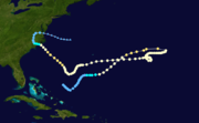
, Ginger spent 27.25 days as a tropical cyclone, lasting from September 6 to October 3. The storm formed northeast of the Bahamas, and for the first nine days of its duration tracked generally eastward or northeastward while gradually strengthening to peak winds of 110 mph (175 km/h). On September 14, Ginger slowed and turned to a general westward track, passing near Bermuda
on September 23. There, the hurricane produced gusty winds and high waves, but no damage.
While over the western Atlantic Ocean
, Ginger became the last target of Project Stormfury
, which sought to weaken hurricanes by depositing silver iodide
into tropical cyclone rainband
s. Ginger ultimately struck North Carolina
on September 30 as a minimal hurricane, lashing the coastline with gusty winds that caused power outages across the region. Heavy rainfall flooded towns and left severe crop damage, with 3 million bushel
s of corn and 1 million bushels of soybean
lost. Damage in the state was estimated at $10 million (1971 USD
, $ USD). Further north, moderate precipitation and winds spread through the Mid-Atlantic states
, although no significant damage was reported outside of North Carolina.
 Hurricane Ginger originated in a cold-core upper-level low
that persisted for several days in early September in the western Atlantic Ocean. The upper-level low was located within a large, persistent area of convection from the Gulf of Mexico
through the central Atlantic, which resembled the Intertropical Convergence Zone
but at a higher latitude. The convective feature was influenced by an anticyclone
located over northern South America
, which was opposite of the typical flow for September. The anticyclone also led to the formation of Hurricane Fern
, Tropical Storm Heidi, and two tropical depressions. By September 5, the low had descended to the surface as its thermal structure warmed, and the next day it developed into a tropical depression about 235 mi (375 km) northeast of the Bahamas.
After forming, the depression moved slowly southeastward for about 24 hours before turning to the northeast, slowly organizing in the process. On September 10, the depression turned eastward, and later that day intensified into Tropical Storm Ginger, the seventh named storm
of the year in the Atlantic, about 325 mi (525 km) south of Bermuda. The storm quickly intensified, and within 24 hours reached winds of 75 mph (120 km/h), making it a hurricane. It turned to the northeast, passing well to the east of Bermuda. Late on September 13, Ginger attained its minimum barometric pressure
of 959 mbar
(28.32 inHg
), and early the next day reached peak maximum sustained wind
s of 110 mph (175 km/h). After reaching a position about halfway between Bermuda and the Azores
, the hurricane's eastward movement halted due to a building ridge
to its north and east. It turned sharply southward before turning and beginning a westerly drift, during which Ginger weakened to minimal hurricane status.
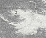
For about six days, Ginger maintained minimal hurricane status. As it meandered over the central Atlantic Ocean, it maintained an unusually large eye
, reaching 80 mi (130 km) in diameter. On September 18, Ginger turned to the south and slowly executed a tight counterclockwise loop within three days. By September 21, the hurricane was tracking south of due west, and the next day suddenly intensified to winds of 90 mph (150 km/h). Its westward track briefly posed a threat to Bermuda, although Ginger passed 115 mi (185 km) south of the island on September 23 while slowly weakening. On September 24, Ginger decelerated before beginning a turn to the southwest. By September 26, Ginger briefly weakened to minimal hurricane strength, although re-intensification resumed as the track turned to the west and northwest. Around that time, Ginger absorbed the smaller and weaker Tropical Storm Janice to its southeast.
For three days, beginning on September 26, the National Oceanic and Atmospheric Administration
deployed planes into the hurricane as part of Project Stormfury
, the fourth hurricane to be a part of the weather control
experiment. The plane dropped silver iodide
into the center of the hurricane, although there was no effect due to Ginger's large eye and diffuse nature; this was the last seeding done by the project. By September 28, Ginger was moving northwestward toward North Carolina and was steadily intensifying. At around 06:00 UTC
the next day, the hurricane reached a secondary peak intensity of 105 mph (165 km/h), which it maintained for about 18 hours. Afterward, Ginger slowly weakened, and late on September 30 it made landfall
near Morehead City, North Carolina
, with winds of 75 mph (120 km/h). It quickly deteriorated over land, weakening first to a tropical storm and then to a tropical depression by late on October 1. Ginger turned to the north, entered southern Virginia, and later turned to the east. On October 3, it transitioned into an extratropical cyclone
while crossing Hampton Roads
into the Atlantic Ocean. The remnants of Ginger continued east-southeastward until being absorbed by a cold front
on October 5.
to evacuate a ship, and also resulted in two cruise ships leaving early. The United States military also evacuated some planes and secured the units that remained. Officials closed all of the island's schools during Ginger's passage.
Before Ginger struck North Carolina, the American Red Cross
set up 28 emergency shelters in six counties, where about 5,500 people stayed during the storm. The National Hurricane Center issued a hurricane watch
from Wilmington, North Carolina
, to Virginia Beach, Virginia
, with gale warnings extending northward to Rehoboth Beach, Delaware
. United States military officials evacuated planes and ships from the Norfolk, Virginia
, region, in addition to flying planes down the coast to warn boaters of the approaching storm. Ferry services around the Outer Banks
were canceled during the storm's passage, while the Coast Guard ordered the evacuation of workers in three lighthouses.
 As the hurricane passed south of Bermuda on September 23, it produced heavy waves, as well as gale
force winds for 17 hours. The Kindley Air Force Base
reported peak gusts of 75 mph (120 km/h). There was no reported damage, and the hurricane's passage failed to alleviate persistent drought conditions.
While Ginger was still in the vicinity of Bermuda, it produced high swells and riptides along the East Coast of the United States
, prompting the issuing of small craft warnings from Florida to North Carolina. Wave heights reached 8 ft (2.4 m) in Sebastian, Florida
, and one person was killed in St. Augustine
from drowning. There were also initial reports of two missing people in Neptune Beach, Florida
, but they were not listed as casualties in the year-end hurricane summary.
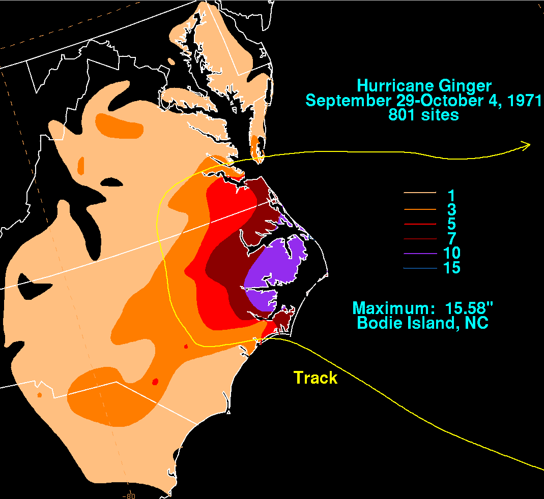
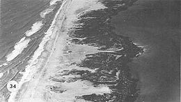
As it moved ashore in North Carolina, Ginger produced a storm tide
of around 6 ft (1.8 m) along the Outer Banks and up to 7 ft (2.1 m) in Pamlico Sound
. The storm dropped heavy rainfall peaking at 15.58 in (395.7 mm) in Bodie Island
along the Outer Banks, making Ginger among the wettest tropical cyclones in the state. Rainfall from the storm extended southwestward into South Carolina, where precipitation reached 4.98 in (126.5 mm) in Cheraw
. In Atlantic Beach, North Carolina
, wind gusts reached 92 mph (148.1 km/h), the highest associated with Ginger in the United States. The hurricane had a large wind field upon moving ashore, affecting a large portion of North Carolina; one county official considered Ginger the largest storm in the region since 1936.
 Strong winds from Ginger damaged store fronts and windows, and also downed power lines and trees. Morehead City, where the hurricane moved ashore, lost power and had debris strewn across the streets. The nearby cities of New Bern
, Beaufort
, and Atlantic Beach also lost power, and one company had 6,000 customers without power. Heavy rainfall caused the Neuse
and Trent rivers to exceed their banks, resulting in flooding. Several oil tanks along the rivers broke open, creating dangerous boating conditions. Up to 4 ft (1.2 m) of water from the Pungo River
flooded most of the city of Belhaven
, and similar flooding occurred in Washington
, entering dozens of buildings and houses. Across the region, the combination of high winds, tides, and flooding closed several bridges and roads, including a portion of U.S. Highway 70. The winds also destroyed several mobile homes, although coastal damage was less than expected. During Ginger's passage, the Salvation Army
and Red Cross provided more than 3,000 people with food assistance.
Further inland, the combination of strong winds and rains left heavy crop damage, destroying 3 million bushels of corn and another million bushels of soybeans; losses to the corn crop were mitigated due to about half of the crop having been harvested before the storm's arrival. Heavy damage was also reported to the peanut crop as well as to various fruits and vegetables. In some locations, up to 15% of the cotton crop was lost, particularly in the northeastern portion of the state. In 45 counties in the eastern portion of the state, farmers affected by the hurricane were eligible for loans from the Farmers Home Administration
, following federal approval from President
Richard Nixon
. Governor Robert W. Scott
requested federal disaster aid for 24 counties, which was denied. Damage in North Carolina was estimated at $10 million (1971 USD
, $ USD), of which about $1 million (1971 USD
, $ USD) was from coastal flooding. One death occurred in Washington when a vehicle accident was possibly caused by a wind gust; however, it was not conclusively linked to Ginger.
As the storm crossed into Virginia, it continued to produce heavy rainfall, including a total of 7.61 in (193.3 mm) in Norfolk
. Near the border between Virginia and North Carolina, the storm produced tides of up to 4 ft (1.2 m) above normal. Gusty winds of over 50 mph (80.5 km/h) downed a few trees, causing scattered power outages. Above-normal tides and waves caused moderate to heavy beach erosion in Virginia Beach
. Further north, Ginger produced above-normal tides, light winds, and scattered rainfall along the Delmarva Peninsula
and northward through New York
.
in 1969, which was the previous record-holder, by three days. In 2003, it was discovered that the 1899 San Ciriaco hurricane lasted as a tropical cyclone longer than Ginger, although its duration as a tropical cyclone was not continuous. This made Ginger the second longest-lived of any Atlantic hurricane, but it remains the storm that lasted the most consecutive days as a tropical cyclone in the basin.
Ginger spent 20 days as a hurricane from September 11 to September 30, one of the longest durations on record at that intensity. In addition, Ginger co-existed with several other tropical cyclones, including on September 11 when there were four named storms at the same time, a rare occurrence; the others were Hurricane Edith, Hurricane Fern, and Tropical Storm Heidi.
Tropical cyclone
A tropical cyclone is a storm system characterized by a large low-pressure center and numerous thunderstorms that produce strong winds and heavy rain. Tropical cyclones strengthen when water evaporated from the ocean is released as the saturated air rises, resulting in condensation of water vapor...
and fifth hurricane of the 1971 Atlantic hurricane season
1971 Atlantic hurricane season
The 1971 Atlantic hurricane season was fairly active with several notable storms. Hurricane Edith, the strongest of the season, was a Category 5 on the Saffir-Simpson scale, the highest category on the scale. It struck Nicaragua at peak intensity, killing dozens, and later hit southern Louisiana...
, Ginger spent 27.25 days as a tropical cyclone, lasting from September 6 to October 3. The storm formed northeast of the Bahamas, and for the first nine days of its duration tracked generally eastward or northeastward while gradually strengthening to peak winds of 110 mph (175 km/h). On September 14, Ginger slowed and turned to a general westward track, passing near Bermuda
Bermuda
Bermuda is a British overseas territory in the North Atlantic Ocean. Located off the east coast of the United States, its nearest landmass is Cape Hatteras, North Carolina, about to the west-northwest. It is about south of Halifax, Nova Scotia, Canada, and northeast of Miami, Florida...
on September 23. There, the hurricane produced gusty winds and high waves, but no damage.
While over the western Atlantic Ocean
Atlantic Ocean
The Atlantic Ocean is the second-largest of the world's oceanic divisions. With a total area of about , it covers approximately 20% of the Earth's surface and about 26% of its water surface area...
, Ginger became the last target of Project Stormfury
Project Stormfury
Project Stormfury was an attempt to weaken tropical cyclones by flying aircraft into them and seeding with silver iodide. The project was run by the United States Government from 1962 to 1983....
, which sought to weaken hurricanes by depositing silver iodide
Silver iodide
Silver iodide is a yellow, inorganic, photosensitive iodide of silver used in photography, in medicine as an antiseptic, and in rainmaking for cloud seeding.-Crystal structure:...
into tropical cyclone rainband
Rainband
A rainband is a cloud and precipitation structure associated with an area of rainfall which is significantly elongated. Rainbands can be stratiform or convective, and are generated by differences in temperature. When noted on weather radar imagery, this precipitation elongation is referred to as...
s. Ginger ultimately struck North Carolina
North Carolina
North Carolina is a state located in the southeastern United States. The state borders South Carolina and Georgia to the south, Tennessee to the west and Virginia to the north. North Carolina contains 100 counties. Its capital is Raleigh, and its largest city is Charlotte...
on September 30 as a minimal hurricane, lashing the coastline with gusty winds that caused power outages across the region. Heavy rainfall flooded towns and left severe crop damage, with 3 million bushel
Bushel
A bushel is an imperial and U.S. customary unit of dry volume, equivalent in each of these systems to 4 pecks or 8 gallons. It is used for volumes of dry commodities , most often in agriculture...
s of corn and 1 million bushels of soybean
Soybean
The soybean or soya bean is a species of legume native to East Asia, widely grown for its edible bean which has numerous uses...
lost. Damage in the state was estimated at $10 million (1971 USD
United States dollar
The United States dollar , also referred to as the American dollar, is the official currency of the United States of America. It is divided into 100 smaller units called cents or pennies....
, $ USD). Further north, moderate precipitation and winds spread through the Mid-Atlantic states
Mid-Atlantic States
The Mid-Atlantic states, also called middle Atlantic states or simply the mid Atlantic, form a region of the United States generally located between New England and the South...
, although no significant damage was reported outside of North Carolina.
Meteorological history
Cold-core low
A cold-core low, also known as a cold low or cold-core cyclone, is a cyclone aloft which has an associated cold pool of air residing at high altitude within the Earth's troposphere. It is a low pressure system which strengthens with height in accordance with the thermal wind relationship. These...
that persisted for several days in early September in the western Atlantic Ocean. The upper-level low was located within a large, persistent area of convection from the Gulf of Mexico
Gulf of Mexico
The Gulf of Mexico is a partially landlocked ocean basin largely surrounded by the North American continent and the island of Cuba. It is bounded on the northeast, north and northwest by the Gulf Coast of the United States, on the southwest and south by Mexico, and on the southeast by Cuba. In...
through the central Atlantic, which resembled the Intertropical Convergence Zone
Intertropical Convergence Zone
The Intertropical Convergence Zone , known by sailors as The Doldrums, is the area encircling the earth near the equator where winds originating in the northern and southern hemispheres come together....
but at a higher latitude. The convective feature was influenced by an anticyclone
Anticyclone
An anticyclone is a weather phenomenon defined by the United States' National Weather Service's glossary as "[a] large-scale circulation of winds around a central region of high atmospheric pressure, clockwise in the Northern Hemisphere, counterclockwise in the Southern Hemisphere"...
located over northern South America
South America
South America is a continent situated in the Western Hemisphere, mostly in the Southern Hemisphere, with a relatively small portion in the Northern Hemisphere. The continent is also considered a subcontinent of the Americas. It is bordered on the west by the Pacific Ocean and on the north and east...
, which was opposite of the typical flow for September. The anticyclone also led to the formation of Hurricane Fern
Hurricane Fern (1971)
Hurricane Fern was the sixth named storm and fourth hurricane of the 1971 Atlantic hurricane season. It formed from a tropical wave which interacted with a large trough of low pressure to form Fern, as well as Hurricane Ginger, Tropical Storm Heidi, and a system designated Tropical Depression...
, Tropical Storm Heidi, and two tropical depressions. By September 5, the low had descended to the surface as its thermal structure warmed, and the next day it developed into a tropical depression about 235 mi (375 km) northeast of the Bahamas.
After forming, the depression moved slowly southeastward for about 24 hours before turning to the northeast, slowly organizing in the process. On September 10, the depression turned eastward, and later that day intensified into Tropical Storm Ginger, the seventh named storm
Tropical cyclone naming
Tropical cyclones have officially been named since 1945 and are named for a variety of reasons, which include to facilitate communications between forecasters and the public when forecasts, watches, and warnings are issued. Names also reduce confusion about what storm is being described, as more...
of the year in the Atlantic, about 325 mi (525 km) south of Bermuda. The storm quickly intensified, and within 24 hours reached winds of 75 mph (120 km/h), making it a hurricane. It turned to the northeast, passing well to the east of Bermuda. Late on September 13, Ginger attained its minimum barometric pressure
Atmospheric pressure
Atmospheric pressure is the force per unit area exerted into a surface by the weight of air above that surface in the atmosphere of Earth . In most circumstances atmospheric pressure is closely approximated by the hydrostatic pressure caused by the weight of air above the measurement point...
of 959 mbar
Bar (unit)
The bar is a unit of pressure equal to 100 kilopascals, and roughly equal to the atmospheric pressure on Earth at sea level. Other units derived from the bar are the megabar , kilobar , decibar , centibar , and millibar...
(28.32 inHg
Inch of mercury
Inches of mercury, ' is a unit of measurement for pressure. It is still widely used for barometric pressure in weather reports, refrigeration and aviation in the United States, but is seldom used elsewhere....
), and early the next day reached peak maximum sustained wind
Maximum sustained wind
The maximum sustained winds associated with a tropical cyclone are a common indicator of the intensity of the storm. Within a mature tropical cyclone, they are found within the eyewall at a distance defined as the radius of maximum wind, or RMW. Unlike gusts, the value of these winds are...
s of 110 mph (175 km/h). After reaching a position about halfway between Bermuda and the Azores
Azores
The Archipelago of the Azores is composed of nine volcanic islands situated in the middle of the North Atlantic Ocean, and is located about west from Lisbon and about east from the east coast of North America. The islands, and their economic exclusion zone, form the Autonomous Region of the...
, the hurricane's eastward movement halted due to a building ridge
Ridge (meteorology)
A ridge is an elongated region of relatively high atmospheric pressure, the opposite of a trough....
to its north and east. It turned sharply southward before turning and beginning a westerly drift, during which Ginger weakened to minimal hurricane status.
For about six days, Ginger maintained minimal hurricane status. As it meandered over the central Atlantic Ocean, it maintained an unusually large eye
Eye (cyclone)
The eye is a region of mostly calm weather found at the center of strong tropical cyclones. The eye of a storm is a roughly circular area and typically 30–65 km in diameter. It is surrounded by the eyewall, a ring of towering thunderstorms where the second most severe weather of a cyclone...
, reaching 80 mi (130 km) in diameter. On September 18, Ginger turned to the south and slowly executed a tight counterclockwise loop within three days. By September 21, the hurricane was tracking south of due west, and the next day suddenly intensified to winds of 90 mph (150 km/h). Its westward track briefly posed a threat to Bermuda, although Ginger passed 115 mi (185 km) south of the island on September 23 while slowly weakening. On September 24, Ginger decelerated before beginning a turn to the southwest. By September 26, Ginger briefly weakened to minimal hurricane strength, although re-intensification resumed as the track turned to the west and northwest. Around that time, Ginger absorbed the smaller and weaker Tropical Storm Janice to its southeast.
For three days, beginning on September 26, the National Oceanic and Atmospheric Administration
National Oceanic and Atmospheric Administration
The National Oceanic and Atmospheric Administration , pronounced , like "noah", is a scientific agency within the United States Department of Commerce focused on the conditions of the oceans and the atmosphere...
deployed planes into the hurricane as part of Project Stormfury
Project Stormfury
Project Stormfury was an attempt to weaken tropical cyclones by flying aircraft into them and seeding with silver iodide. The project was run by the United States Government from 1962 to 1983....
, the fourth hurricane to be a part of the weather control
Weather control
Weather control is the act of manipulating or altering certain aspects of the environment to produce desirable changes in weather. Weather control can have the goal of preventing damaging weather, such as hurricanes or tornadoes, from occurring; of causing beneficial weather, such as rainfall in...
experiment. The plane dropped silver iodide
Silver iodide
Silver iodide is a yellow, inorganic, photosensitive iodide of silver used in photography, in medicine as an antiseptic, and in rainmaking for cloud seeding.-Crystal structure:...
into the center of the hurricane, although there was no effect due to Ginger's large eye and diffuse nature; this was the last seeding done by the project. By September 28, Ginger was moving northwestward toward North Carolina and was steadily intensifying. At around 06:00 UTC
Coordinated Universal Time
Coordinated Universal Time is the primary time standard by which the world regulates clocks and time. It is one of several closely related successors to Greenwich Mean Time. Computer servers, online services and other entities that rely on having a universally accepted time use UTC for that purpose...
the next day, the hurricane reached a secondary peak intensity of 105 mph (165 km/h), which it maintained for about 18 hours. Afterward, Ginger slowly weakened, and late on September 30 it made landfall
Landfall (meteorology)
Landfall is the event of a tropical cyclone or a waterspout coming onto land after being over water. When a waterspout makes landfall it is reclassified as a tornado, which can then cause damage inland...
near Morehead City, North Carolina
Morehead City, North Carolina
Morehead City is a port city in Carteret County, North Carolina, United States. The population was 8,661 at the 2010 census. Morehead City celebrated the 150th anniversary of its founding on May 5, 2007...
, with winds of 75 mph (120 km/h). It quickly deteriorated over land, weakening first to a tropical storm and then to a tropical depression by late on October 1. Ginger turned to the north, entered southern Virginia, and later turned to the east. On October 3, it transitioned into an extratropical cyclone
Extratropical cyclone
Extratropical cyclones, sometimes called mid-latitude cyclones or wave cyclones, are a group of cyclones defined as synoptic scale low pressure weather systems that occur in the middle latitudes of the Earth having neither tropical nor polar characteristics, and are connected with fronts and...
while crossing Hampton Roads
Hampton Roads
Hampton Roads is the name for both a body of water and the Norfolk–Virginia Beach metropolitan area which surrounds it in southeastern Virginia, United States...
into the Atlantic Ocean. The remnants of Ginger continued east-southeastward until being absorbed by a cold front
Cold front
A cold front is defined as the leading edge of a cooler mass of air, replacing a warmer mass of air.-Development of cold front:The cooler and denser air wedges under the less-dense warmer air, lifting it...
on October 5.
Preparations
The threat of the hurricane in Bermuda prompted the British Royal NavyRoyal Navy
The Royal Navy is the naval warfare service branch of the British Armed Forces. Founded in the 16th century, it is the oldest service branch and is known as the Senior Service...
to evacuate a ship, and also resulted in two cruise ships leaving early. The United States military also evacuated some planes and secured the units that remained. Officials closed all of the island's schools during Ginger's passage.
Before Ginger struck North Carolina, the American Red Cross
American Red Cross
The American Red Cross , also known as the American National Red Cross, is a volunteer-led, humanitarian organization that provides emergency assistance, disaster relief and education inside the United States. It is the designated U.S...
set up 28 emergency shelters in six counties, where about 5,500 people stayed during the storm. The National Hurricane Center issued a hurricane watch
Tropical cyclone warnings and watches
Warnings and watches are two levels of alert issued by national weather forecasting bodies to coastal areas threatened by the imminent approach of a tropical cyclone of tropical storm or hurricane intensity. They are notices to the local population and civil authorities to make appropriate...
from Wilmington, North Carolina
Wilmington, North Carolina
Wilmington is a port city in and is the county seat of New Hanover County, North Carolina, United States. The population is 106,476 according to the 2010 Census, making it the eighth most populous city in the state of North Carolina...
, to Virginia Beach, Virginia
Virginia Beach, Virginia
Virginia Beach is an independent city located in the Hampton Roads metropolitan area of Virginia, on the Atlantic Ocean at the mouth of the Chesapeake Bay...
, with gale warnings extending northward to Rehoboth Beach, Delaware
Rehoboth Beach, Delaware
Rehoboth Beach is a city in Sussex County, Delaware, United States. According to the 2010 census, the population is 1,327, a decrease of 11.2% from 2000...
. United States military officials evacuated planes and ships from the Norfolk, Virginia
Norfolk, Virginia
Norfolk is an independent city in the Commonwealth of Virginia in the United States. With a population of 242,803 as of the 2010 Census, it is Virginia's second-largest city behind neighboring Virginia Beach....
, region, in addition to flying planes down the coast to warn boaters of the approaching storm. Ferry services around the Outer Banks
Outer Banks
The Outer Banks is a 200-mile long string of narrow barrier islands off the coast of North Carolina, beginning in the southeastern corner of Virginia Beach on the east coast of the United States....
were canceled during the storm's passage, while the Coast Guard ordered the evacuation of workers in three lighthouses.
Impact
Gale
A gale is a very strong wind. There are conflicting definitions of how strong a wind must be to be considered a gale. The U.S. government's National Weather Service defines a gale as 34–47 knots of sustained surface winds. Forecasters typically issue gale warnings when winds of this strength are...
force winds for 17 hours. The Kindley Air Force Base
Kindley Air Force Base
Kindley Air Force Base was a United States Air Force base in Bermuda from 1948–1970, having been operated from 1943 to 1948 by the United States Army Air Force as Kindley Field.-World War II:...
reported peak gusts of 75 mph (120 km/h). There was no reported damage, and the hurricane's passage failed to alleviate persistent drought conditions.
While Ginger was still in the vicinity of Bermuda, it produced high swells and riptides along the East Coast of the United States
East Coast of the United States
The East Coast of the United States, also known as the Eastern Seaboard, refers to the easternmost coastal states in the United States, which touch the Atlantic Ocean and stretch up to Canada. The term includes the U.S...
, prompting the issuing of small craft warnings from Florida to North Carolina. Wave heights reached 8 ft (2.4 m) in Sebastian, Florida
Sebastian, Florida
Sebastian is a city in Indian River County, in the Treasure Coast region of Florida, United States. The population was 16,181 at the 2000 census. In 2004, the population recorded by the U.S. Census Bureau was 18,671. As of 2010, the population recorded by the U.S...
, and one person was killed in St. Augustine
St. Augustine, Florida
St. Augustine is a city in the northeast section of Florida and the county seat of St. Johns County, Florida, United States. Founded in 1565 by Spanish explorer and admiral Pedro Menéndez de Avilés, it is the oldest continuously occupied European-established city and port in the continental United...
from drowning. There were also initial reports of two missing people in Neptune Beach, Florida
Neptune Beach, Florida
Neptune Beach is a beachfront city in Duval County, Florida, United States, located to the east of Jacksonville. When the majority of communities in Duval County consolidated with the city of Jacksonville in 1968, Neptune Beach, along with Jacksonville Beach, Atlantic Beach, and Baldwin, remained...
, but they were not listed as casualties in the year-end hurricane summary.
As it moved ashore in North Carolina, Ginger produced a storm tide
Storm tide
A storm tide is a tide with a high flood period caused by a storm. Storm tides can be a severe danger to the coast and the people living along the coast. The water level can rise to more than 5 meters above the normal tide....
of around 6 ft (1.8 m) along the Outer Banks and up to 7 ft (2.1 m) in Pamlico Sound
Pamlico Sound
Pamlico Sound in North Carolina, is the largest lagoon along the U.S. East Coast, being long and 24 to 48 km wide. It is a body of water separated from the Atlantic Ocean by the Outer Banks, a row of low, sandy barrier islands, including Cape Hatteras. The Neuse and Pamlico rivers flow in...
. The storm dropped heavy rainfall peaking at 15.58 in (395.7 mm) in Bodie Island
Bodie Island
Bodie Island is a long, narrow barrier peninsula that forms the northernmost portion of the Outer Banks of North Carolina. The land that is most commonly referred to as Bodie Island was at one time a true island, however the inlet separating it from the Currituck Banks peninsula in the north closed...
along the Outer Banks, making Ginger among the wettest tropical cyclones in the state. Rainfall from the storm extended southwestward into South Carolina, where precipitation reached 4.98 in (126.5 mm) in Cheraw
Cheraw, South Carolina
Cheraw is a town on the Pee Dee River in Chesterfield County, South Carolina, United States. The population was 5,524 at the 2000 census and center of an urban cluster with a total population of 9,069. It has been nicknamed "The Prettiest Town in Dixie." The harbor tub USS Cheraw was named in the...
. In Atlantic Beach, North Carolina
Atlantic Beach, North Carolina
-Demographics:As of the census of 2008, there were 1,815 people, 971 households, and 498 families residing in the town. The population density was . There were 4,728 housing units at an average density of 2,206.0 per square mile...
, wind gusts reached 92 mph (148.1 km/h), the highest associated with Ginger in the United States. The hurricane had a large wind field upon moving ashore, affecting a large portion of North Carolina; one county official considered Ginger the largest storm in the region since 1936.
New Bern, North Carolina
New Bern is a city in Craven County, North Carolina with a population of 29,524 as of the 2010 census.. It is located at the confluence of the Trent and the Neuse rivers...
, Beaufort
Beaufort, North Carolina
Beaufort is a town in Carteret County, North Carolina, United States. Established in 1709, it is the third-oldest town in North Carolina.The population was 4,189 at the 2008 census and it is the county seat of Carteret County...
, and Atlantic Beach also lost power, and one company had 6,000 customers without power. Heavy rainfall caused the Neuse
Neuse River
The Neuse River is a river rising in the Piedmont of North Carolina and emptying into Pamlico Sound below New Bern. Its total length is approximately , making it the longest river entirely contained in North Carolina. The Trent River joins it at New Bern. Its drainage basin, measuring in area,...
and Trent rivers to exceed their banks, resulting in flooding. Several oil tanks along the rivers broke open, creating dangerous boating conditions. Up to 4 ft (1.2 m) of water from the Pungo River
Pungo River
The Pungo River is a river in eastern North Carolina, USA. It originally began in the Great Dismal Swamp in Washington County, North Carolina; the upper part of the river has since been supplanted by the Pungo River Canal, dug in the 1950s to improve drainage of local farmland. The river flows...
flooded most of the city of Belhaven
Belhaven, North Carolina
Belhaven is a town in Beaufort County, North Carolina, United States. The population was 1,968 at the 2000 census. Belhaven is located in North Carolina's Inner Banks region....
, and similar flooding occurred in Washington
Washington, North Carolina
Washington is a city in Beaufort County, North Carolina, United States. The population was 9,744 at the 2010 census. It is the county seat of Beaufort County. The closest major city is Greenville, approximately 20 miles to the west....
, entering dozens of buildings and houses. Across the region, the combination of high winds, tides, and flooding closed several bridges and roads, including a portion of U.S. Highway 70. The winds also destroyed several mobile homes, although coastal damage was less than expected. During Ginger's passage, the Salvation Army
Salvation Army
The Salvation Army is a Protestant Christian church known for its thrift stores and charity work. It is an international movement that currently works in over a hundred countries....
and Red Cross provided more than 3,000 people with food assistance.
Further inland, the combination of strong winds and rains left heavy crop damage, destroying 3 million bushels of corn and another million bushels of soybeans; losses to the corn crop were mitigated due to about half of the crop having been harvested before the storm's arrival. Heavy damage was also reported to the peanut crop as well as to various fruits and vegetables. In some locations, up to 15% of the cotton crop was lost, particularly in the northeastern portion of the state. In 45 counties in the eastern portion of the state, farmers affected by the hurricane were eligible for loans from the Farmers Home Administration
Farmers Home Administration
In 1946 Farmers Home Administration replaced the Farm Security Administration which superseded the Resettlement Administration. Its mission and programs involved extending credit for agriculture and rural development. Direct and guaranteed credit went to individual farmers, low-income families,...
, following federal approval from President
President of the United States
The President of the United States of America is the head of state and head of government of the United States. The president leads the executive branch of the federal government and is the commander-in-chief of the United States Armed Forces....
Richard Nixon
Richard Nixon
Richard Milhous Nixon was the 37th President of the United States, serving from 1969 to 1974. The only president to resign the office, Nixon had previously served as a US representative and senator from California and as the 36th Vice President of the United States from 1953 to 1961 under...
. Governor Robert W. Scott
Robert W. Scott
Robert Walter "Bob" Scott was the 67th Governor of the state of North Carolina from 1969 to 1973. He was born in Haw River, North Carolina.The son of North Carolina Governor W...
requested federal disaster aid for 24 counties, which was denied. Damage in North Carolina was estimated at $10 million (1971 USD
United States dollar
The United States dollar , also referred to as the American dollar, is the official currency of the United States of America. It is divided into 100 smaller units called cents or pennies....
, $ USD), of which about $1 million (1971 USD
United States dollar
The United States dollar , also referred to as the American dollar, is the official currency of the United States of America. It is divided into 100 smaller units called cents or pennies....
, $ USD) was from coastal flooding. One death occurred in Washington when a vehicle accident was possibly caused by a wind gust; however, it was not conclusively linked to Ginger.
As the storm crossed into Virginia, it continued to produce heavy rainfall, including a total of 7.61 in (193.3 mm) in Norfolk
Norfolk, Virginia
Norfolk is an independent city in the Commonwealth of Virginia in the United States. With a population of 242,803 as of the 2010 Census, it is Virginia's second-largest city behind neighboring Virginia Beach....
. Near the border between Virginia and North Carolina, the storm produced tides of up to 4 ft (1.2 m) above normal. Gusty winds of over 50 mph (80.5 km/h) downed a few trees, causing scattered power outages. Above-normal tides and waves caused moderate to heavy beach erosion in Virginia Beach
Virginia Beach, Virginia
Virginia Beach is an independent city located in the Hampton Roads metropolitan area of Virginia, on the Atlantic Ocean at the mouth of the Chesapeake Bay...
. Further north, Ginger produced above-normal tides, light winds, and scattered rainfall along the Delmarva Peninsula
Delmarva Peninsula
The Delmarva Peninsula is a large peninsula on the East Coast of the United States, occupied by most of Delaware and portions of Maryland and Virginia...
and northward through New York
New York
New York is a state in the Northeastern region of the United States. It is the nation's third most populous state. New York is bordered by New Jersey and Pennsylvania to the south, and by Connecticut, Massachusetts and Vermont to the east...
.
Record longevity
Hurricane Ginger formed on September 6 and lasted until October 3, for a total of 27.25 days. Its duration surpassed that of Hurricane IngaHurricane Inga (1969)
Hurricane Inga is the third longest-lived Atlantic hurricane on record. The 11th tropical cyclone and 9th named storm of the 1969 Atlantic hurricane season, Inga developed on September 20 in the central Atlantic and tracked westward. After attaining tropical storm status, the system deteriorated...
in 1969, which was the previous record-holder, by three days. In 2003, it was discovered that the 1899 San Ciriaco hurricane lasted as a tropical cyclone longer than Ginger, although its duration as a tropical cyclone was not continuous. This made Ginger the second longest-lived of any Atlantic hurricane, but it remains the storm that lasted the most consecutive days as a tropical cyclone in the basin.
Ginger spent 20 days as a hurricane from September 11 to September 30, one of the longest durations on record at that intensity. In addition, Ginger co-existed with several other tropical cyclones, including on September 11 when there were four named storms at the same time, a rare occurrence; the others were Hurricane Edith, Hurricane Fern, and Tropical Storm Heidi.
See also
- List of wettest tropical cyclones in North Carolina
- List of North Carolina hurricanes
- Tropical Storm Ginger – a storm of the same name in 1967