
Gwbert
Encyclopedia
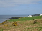
Gwbert (ˈgubɛrt, ), also known as Gwbert-on-Sea, is a small cliff
top coastal hamlet
in Y Ferwig
community
, Ceredigion
, Wales
. It lies at the most southerly coastal point of Ceredigion, on the eastern shore of the Teifi
estuary
, from where there are views westwards over Cardigan Bay
, and south-westwards to Poppit Sands
and the headland of Cemaes Head, in neighbouring Pembrokeshire
. It is most easily reached by the B4548 road from the town of Cardigan
(Welsh : Aberteifi), 2.8 miles (4.5 km) away.
Gwbert as seen today essentially dates back only as far as the early 20th century, the most prominent buildings being the extensive Cliff Hotel and the smaller Gwbert Hotel. The settlement has an interesting history as a failed would-be resort, but despite its lack of facilities it is a popular holiday venue, being within easy reach of the Ceredigion and Pembrokeshire coastlines, both rich in scenery and wildlife.
The name Gwbert is thought to derive from a Celtic dedication (i.e. Cubert), suggesting that a chapel may have existed here at one time. Gwbert, a wandering saint, is said to have landed here and sheltered in a cave. In fact Gwbert is among a group of five Saints (the others being Pedrog, Briog, Carannog and Meugana) honoured in church dedications near the mouth of the river Teifi, and also in churches lying in close proximity to each other in mid-Cornwall
, and then again in neighbouring churches in Brittany
.
Although Gwbert is not recorded, by name, as a settlement in medieval documentation, Towyn Farm - on the northern edge of the adjoining dunes - was recorded as a late medieval gentry house/settlement, owned by Gwilym ap Einon, constable of Cardigan Castle
, in 1326.
The name "Pant-y-Gilbert" appears on maps of 1697, with both this and "Gwbert" used by 1748. The spelling "Goobert" appears on an 1838 map.
The 1851 census recorded 378 inhabitants.
In 2001 the rural
community
of Y Ferwig
(which extends south-east of the A487, and of which Gwbert comprises only some 15% in area) had a population of 1,177. Of these :
The main settlement of Gwbert today comprises some 50 properties, mostly located on Coronation Drive and Evelyn Terrace, a number of which are not owner-occupied, but are leased out for holiday use.
Employment in Gwbert is provided by the Cliff Hotel, the Gwbert Hotel, and Cardigan Island Farm Park. Many of these workers travel in from nearby areas, notably from Cardigan, which also provides an additional source of employment for Gwbert's small working population.
Both the Cliff Hotel and Gwbert Hotel are open to non-residents for food and drinks.
Gwbert incorporates the adjacent Towyn Burrows (also called Towyn Warren), much of which is now home to Cardigan Golf Club, the Club House being accessed via Evelyn Terrace. The Golf Club invites visitors to play any day of the week, by arrangement. The Club House at Gwbert serves both restaurant and bar meals.
There is a very limited bus service which runs primarily to/from Cardigan.
The nearest railway station (Cardigan's station closed in 1963) is at Fishguard
, some 20 miles (32.2 km) away.
Despite the presence of hotels, and the nearby caravan park and boatyard at Patch, the impact of the tourist industry on the landscape is not great.
. In 1888 the local Corporation met regarding the leases of the new proposed Villa residences, and in 1889 The Cardigan & Tivyside Advertiser was reporting on "Cardigan's 'New Brighton'", with Mr C.E.D. Morgan-Richardson, a Cardigan solicitor and businessman, named to head a company to develop the old Gwbert Inn property through the purchase of 96 acres of land, and with capital of £20,000. In addition to the considerable development of the Gwbert Inn, a row of villa boarding houses were to be built along what became Evelyn's Terrace. (Morgan-Richardson was later to become mayor of Cardigan.)
In July 1889 the local paper wrote of Gwbert : "Surrounded on two sides by the sea, its rocky bounderies are fringed by golden sands, conveniently approached, abounding with charming nooks for the privacy of bathing without machines, while the magnificent scenery of the opposite, or Pembrokeshire coast, including its bold rocky headlands, glistening sands, snug homesheads &c., form a picture not easilty rivalled." There was even talk of the construction of a landing jetty.
Journalist Ebenezer Rees, writing in 1894, referred to Gwbert as "Cardigan's famous and favourite watering place"
In 1897 a new road to Gwbert was built to open up the area; this road initially ran from the Cliff Hotel to Patch (where Cardigan Boating Club is located) but it was many years before it reached its original intended destination, namely Nant-y-Ferwig Bridge. In construction of the new road, parts of the old road ceased to be used, though it can still be traced. Some eleven of the Carn Meini (Preseli Hills
) stones have now been utilised as gateposts on the eastern side of the old road, three south of the Gwbert road, and eight to the north. Seven others can be seen straddling a lane leading to Stepside Farm.
Kelly's Directory of South Wales (1895) stated : "Gwbert, a small place on the coast in this parish, on the east side of the estuary of the Teifi, is now rising into favour as a watering place." The adjacent Cardigan & Tivyside Golf Club opened in this year.
In The Rivers of Great Britain (1897) Charles Edwardes wrote : "If you wish to see Teifi, or Tivy, quite to its end, it is worth while to go north another three miles, to Gwbert-on-the-Sea, a distinctly primitive and pleasing watering-place, facing Kemmaes Head, with the mile and a half of Teifi's mouth (at its widest) intervening."
In Walks and Wanderings in County Cardigan (1902) E.R.H.Turner described Gwbert as "a spot on the coast marked by a hotel and a few villas, but sufficiently near to Cardigan to be a favourite pleasure resort."
The following year the local newspaper reported on the progress of Gwbert as a residential centre, reporting again in 1906 on the "bright look to the development of the resort". In 1910 it carried an article entitled "Gwbert on Sea, where is it and what is it?"
The Encyclopedia Britannia of 1911 also acknowledged the growth : "In modern times several small watering-places have sprung up on the coast, notably at Borth, New Quay, Tresaith, Aberporth and Gwbert."
Growth, whilst clearly recognised, was limited, and The English Illustrated Magazine (vol 39, 1908) wrote "Amongst these [places worthy of attention] may be mentioned Gwbert-on-Sea - where satisfactory bathing is to be obtained. Perched on the brown cliffs which domionate the dancing waves, the little village has, up till now, almost remained undiscovered."
Despite, however, the developers' ambitious plans for growth, along with much publicity and promotion in journals and books of the period, a lack of appropriate accommodation and a derth of facilities meant that relatively little came about, and Gwbert never grew to be anything larger than a very minor resort.
In 1911 Gwbert held grand pre-Coronation
festivities for King George V
.
After rebuilding and considerable extension it re-opened in April 1909 as the new Cliff Hotel (the name "Gwbert Hotel" being later used by another hotel), and the golf links was set out to additionally attract visitors. (The Cardigan and Tivyside Golf Club on the adjacent burrows had "died a natural death" by this time, through lack of patronage.) Early publicity postcards from the hotel proclaimed : "The Bishop of Bangor writes of Gwbert - This is one of the most charming spots I ever visited."
The Cliff Hotel was sold to new owners in April 1913 , and more recently it has again been extended and refurbished with the addition of more rooms and a new spa and leisure complex.
. It has been designated a Special Area of Conservation
.
The Ceredigion Coast Path runs northwards from Gwbert, towards and beyond Mwnt, but it does not follow the coastline itself. The official route currently runs eastwards to Y Ferwig, thence northwards to the coastline at Mwnt
. An alternative route, heading north from Cardigan Island Farm Park to reach the coastline much sooner, is currently under dispute, with alleged dangerous cliff sections.
The sandy area of Towyn Burrows, which comprises much of Gwbert, was caused by strong onshore winds following the last Ice Age
, which left deposits of Irish Sea glacial till
, now overshadowed by the extensive dunes.
Gwbert beach (at Patch, south of the hamlet) is the nearest beach to Cardigan, is south-west facing, and is sandy. Despite early 20th century promotion, the tide here can drastically change the shape of the beach, and swimming can be dangerous. Rather than a family beach, it has a reputation for sailing, sea-fishing and extreme sports.
Although Gwbert hamlet has a cliff-top location, it is possible to get down to the sea by Craig-y-Gwbert, below the Cliff Hotel. Steps cut into the rock allow access to Cowley beach and a neighbouring enclosed small bay.
In 1977 concerns were expressed about erosion along the coastline between Cardigan and Gwbert, notably at Patch, where the road was only 45 feet from the top of the eroding boulder clay
cliffs.
In the early 1990s, following further erosion at Pen-Yr-Ergyd, remedial work was undertaken, whereby six groyne
s consisting of rock mounds were constructed. The scheme cost Ceredigion County Council some £151,000, half of this coming from the European Regional Development Fund
.
The coastline around Gwbert is rugged - particularly from Patch headland northwards - and in 1922 the trawler "Princess Mary" was lost on the coast here. A decade later, in 1934, the S.S. Herefordshire ran aground near Cardigan Island, the four men aboard the vessel being rescued through the use of rocket life-saving equipment that was kept at Gwbert.
Today on the cliff edge there is a Coastguard
lookout post, part of the Maritime and Coastguard Agency
Emergency Response. An RNLI lifeboat operates from nearby Poppit Sands, the centre being visible across the estuary from Gwbert.
Teifi Boating Club (Clwb Cychod Teifi) is based at The Patch, Gwbert, on the estuary road towards Cardigan.
Bottlenose dolphin
s and porpoise
s can often be seen swimming in the bay, as can grey seals
from the neighbouring Cardigan Island
colony. Cardigan Bay has a resident population of over 100 bottlenose dolphins (some estimates exceed 200), which are most frequently seen off southern Ceredigion between Gwbert and Aberaeron
. (This is Europe's largest resident population of bottlenose dolphins, the UK's only other one being in the Moray Firth
, Scotland
.)
Seals also live in the network of caves below Gwbert's Cardigan Island Coastal Farm Park, where they can often be seen basking on the rocks, notably on Carreg Lydan (Wide Rock).
In recent years visiting basking sharks, sun fish
, and even Orcas, Minke Whale
s and Humpback Whale
s have been spotted. In September 1979 a 24-foot whale was found washed up dead at the foot of the rocks by Clunyrynys Farm, Gwbert. On inspection of the carcass, a scientific officer found a rare 15-spined sea stickleback
feeding on it.
Chough
s (now totally disappeared from England) live in holes in the cliffs, and the coast at Gwbert is also home to gannet
s, razorbill
s, guillemot
s, Manx shearwater
s, black headed gulls and fulmar petrels
. On the land other frequently spotted birds are birds of prey such as red kite
s, buzzard
s, peregrine falcon
s, kestrel
s and sparrow-hawk
s. Skylark
s are also a regular sight.
At low tide a variety of wading birds can be seen in the estuary.
During summer months many dozens of Canada geese can daily be seen heading northwards over Gwbert towards the Dyfi estuary marshes, returning each evening. These feral Geese reside in the Teifi estuary and valley up as far as Newcastle Emlyn
.
Boat trips to see the wildlife off the Gwbert coast run from the Teifi Boating Club jetty at Gwbert, as well as from Poppit Sands, and Cardigan.
, Gwbert experiences a maritime climate with cool summers and mild winters. The nearest official Met Office
weather station
for which online records are available is at Aberporth
, which is 5.7 miles (9.1 km) ENE of Gwbert, and has a similar coastal aspect.
Typically, less than 3 days of the year will reach 25.1 °C (77.2 °F) of above, the warmest of which should rise to 26.8 °C (80.2 °F) - The highest temperature recorded was 32.7 °C (90.9 °F), during July 2006.
On average 18.3 nights will report air frost and the coldest night of the year should fall to -4.5 C. The lowest recorded temperature was -9.9 C, during January 1963.
Rainfall averages around 870mm a year, with at least 1mm falling on 143.5 days.
A detailed daily weather forecast for Gwbert, including sea temperature, can be found here.
fort, but no associated field systems have been found. It is only accessible via a narrow neck of land, and defended by a substantial earthen bank, measuring 2.5m in height and 40m in length. The entrance is a small gap through this bank. Today there are remains of lime pits within this area, together with a Grade 2 listed lime kiln , and the Cliff Hotel's 9-hole golf course makes use of the promontory. An aerial view of Craig y Gwbert, can be seen here.
In the mid-1970's a sand-covered medieval rubbish pit (3m diameter and 1.5m deep) was excavated in the eroding cliff-section on Coronation Drive, south-west of the present village of Gwbert. Some medieval leather shoes were recovered, as were 75 items of pottery, which has given its name to "Gwbert Ware", a variation of Dyfed Gravel-Tempered Ware , this being very gravelly without much glaze. Examples of these 13th century items can be seen in Cardigan Heritage Centre, with images available on-line. Other finds in the pit included animal bones including an Ox scapula and a stone axe found in the loose. Excavation also revealed earlier plough soil and cattle hoof prints under the sand.
in 1838 as an ordained minister, where he acquired a reputation as an eloquent and powerful speaker, and one of the leading lights of the London pulpit. During periods of physical weakness he would return to Wales to recover, but continued ill health forced him to retire early. He lived the last year of his life at Gwbert, where he died at The Lodge on 26 July 1865.
Cliff
In geography and geology, a cliff is a significant vertical, or near vertical, rock exposure. Cliffs are formed as erosion landforms due to the processes of erosion and weathering that produce them. Cliffs are common on coasts, in mountainous areas, escarpments and along rivers. Cliffs are usually...
top coastal hamlet
Hamlet (place)
A hamlet is usually a rural settlement which is too small to be considered a village, though sometimes the word is used for a different sort of community. Historically, when a hamlet became large enough to justify building a church, it was then classified as a village...
in Y Ferwig
Y Ferwig
Y Ferwig is a small village and community about 2 to 3 miles from Cardigan, Wales.- Amenities :The village is made up of a parish church and a few houses. The community includes the village of Gwbert and Cardigan Island, and the National Trust area of Mwnt.-External links:*...
community
Community (Wales)
A community is a division of land in Wales that forms the lowest-tier of local government in Wales. Welsh communities are analogous to civil parishes in England....
, Ceredigion
Ceredigion
Ceredigion is a county and former kingdom in mid-west Wales. As Cardiganshire , it was created in 1282, and was reconstituted as a county under that name in 1996, reverting to Ceredigion a day later...
, Wales
Wales
Wales is a country that is part of the United Kingdom and the island of Great Britain, bordered by England to its east and the Atlantic Ocean and Irish Sea to its west. It has a population of three million, and a total area of 20,779 km²...
. It lies at the most southerly coastal point of Ceredigion, on the eastern shore of the Teifi
River Teifi
The River Teifi forms the boundary between the counties of Ceredigion and Carmarthenshire in south-west Wales for most of its 75 mile length, flowing into the sea below the town of Cardigan. The catchment of the river is estimated to be 1,008 square kilometres yielding an average flow at Glan...
estuary
Estuary
An estuary is a partly enclosed coastal body of water with one or more rivers or streams flowing into it, and with a free connection to the open sea....
, from where there are views westwards over Cardigan Bay
Cardigan Bay
Cardigan Bay is a large inlet of the Irish Sea, indenting the west coast of Wales between Bardsey Island, Gwynedd in the north, and Strumble Head, Pembrokeshire at its southern end. It is the largest bay in Wales....
, and south-westwards to Poppit Sands
Poppit Sands
Poppit Sands is primarily known as a sandy Blue Flag beach in northern Pembrokeshire, Wales It lies on the estuary of the River Teifi near Cardigan, and is adjacent to St. Dogmael's beach, at its eastern estuary end. The nearest village is St Dogmaels, and it offers views across the estuary and...
and the headland of Cemaes Head, in neighbouring Pembrokeshire
Pembrokeshire
Pembrokeshire is a county in the south west of Wales. It borders Carmarthenshire to the east and Ceredigion to the north east. The county town is Haverfordwest where Pembrokeshire County Council is headquartered....
. It is most easily reached by the B4548 road from the town of Cardigan
Cardigan, Ceredigion
Cardigan is a town in the county of Ceredigion in Mid Wales. It lies on the estuary of the River Teifi at the point where Ceredigion meets Pembrokeshire. It was the county town of the pre-1974 county of Cardiganshire. It is the second largest town in Ceredigion. The town's population was 4,203...
(Welsh : Aberteifi), 2.8 miles (4.5 km) away.
Gwbert as seen today essentially dates back only as far as the early 20th century, the most prominent buildings being the extensive Cliff Hotel and the smaller Gwbert Hotel. The settlement has an interesting history as a failed would-be resort, but despite its lack of facilities it is a popular holiday venue, being within easy reach of the Ceredigion and Pembrokeshire coastlines, both rich in scenery and wildlife.
Etymology
Before the area was populated at the end of the 19th century, it was often called The Gwbert.The name Gwbert is thought to derive from a Celtic dedication (i.e. Cubert), suggesting that a chapel may have existed here at one time. Gwbert, a wandering saint, is said to have landed here and sheltered in a cave. In fact Gwbert is among a group of five Saints (the others being Pedrog, Briog, Carannog and Meugana) honoured in church dedications near the mouth of the river Teifi, and also in churches lying in close proximity to each other in mid-Cornwall
Cornwall
Cornwall is a unitary authority and ceremonial county of England, within the United Kingdom. It is bordered to the north and west by the Celtic Sea, to the south by the English Channel, and to the east by the county of Devon, over the River Tamar. Cornwall has a population of , and covers an area of...
, and then again in neighbouring churches in Brittany
Brittany
Brittany is a cultural and administrative region in the north-west of France. Previously a kingdom and then a duchy, Brittany was united to the Kingdom of France in 1532 as a province. Brittany has also been referred to as Less, Lesser or Little Britain...
.
Although Gwbert is not recorded, by name, as a settlement in medieval documentation, Towyn Farm - on the northern edge of the adjoining dunes - was recorded as a late medieval gentry house/settlement, owned by Gwilym ap Einon, constable of Cardigan Castle
Cardigan Castle
Cardigan Castle is a castle located in Cardigan, Ceredigion, Wales.-History:The first motte-and-bailey castle was built a mile away from the present site, probably about the time of the founding of the town by Roger de Montgomery, a Norman baron....
, in 1326.
The name "Pant-y-Gilbert" appears on maps of 1697, with both this and "Gwbert" used by 1748. The spelling "Goobert" appears on an 1838 map.
Population
In 1833 the population of the whole Ferwig parish was 439.The 1851 census recorded 378 inhabitants.
In 2001 the rural
Rural
Rural areas or the country or countryside are areas that are not urbanized, though when large areas are described, country towns and smaller cities will be included. They have a low population density, and typically much of the land is devoted to agriculture...
community
Community (Wales)
A community is a division of land in Wales that forms the lowest-tier of local government in Wales. Welsh communities are analogous to civil parishes in England....
of Y Ferwig
Y Ferwig
Y Ferwig is a small village and community about 2 to 3 miles from Cardigan, Wales.- Amenities :The village is made up of a parish church and a few houses. The community includes the village of Gwbert and Cardigan Island, and the National Trust area of Mwnt.-External links:*...
(which extends south-east of the A487, and of which Gwbert comprises only some 15% in area) had a population of 1,177. Of these :
- 63.1% spoke, read or wrote Welsh
- 31.4% were ages from 45 to 64, and 22.17% were aged 65 or over
- the meanMeanIn statistics, mean has two related meanings:* the arithmetic mean .* the expected value of a random variable, which is also called the population mean....
age of the whole population was 44.3, the medianMedianIn probability theory and statistics, a median is described as the numerical value separating the higher half of a sample, a population, or a probability distribution, from the lower half. The median of a finite list of numbers can be found by arranging all the observations from lowest value to...
age being 47.0 - 40% were economically active
- 22.4% reported having a limiting long-term illness
The main settlement of Gwbert today comprises some 50 properties, mostly located on Coronation Drive and Evelyn Terrace, a number of which are not owner-occupied, but are leased out for holiday use.
Employment in Gwbert is provided by the Cliff Hotel, the Gwbert Hotel, and Cardigan Island Farm Park. Many of these workers travel in from nearby areas, notably from Cardigan, which also provides an additional source of employment for Gwbert's small working population.
Facilities
Gwbert has no shop, church or school. The nearest churches and primary school are at Y Ferwig, some 1.5 miles (2.4 km) away, these all being built before any development at Gwbert. The nearest secondary school is in Cardigan.Both the Cliff Hotel and Gwbert Hotel are open to non-residents for food and drinks.
Gwbert incorporates the adjacent Towyn Burrows (also called Towyn Warren), much of which is now home to Cardigan Golf Club, the Club House being accessed via Evelyn Terrace. The Golf Club invites visitors to play any day of the week, by arrangement. The Club House at Gwbert serves both restaurant and bar meals.
There is a very limited bus service which runs primarily to/from Cardigan.
The nearest railway station (Cardigan's station closed in 1963) is at Fishguard
Fishguard
Fishguard is a coastal town in Pembrokeshire, south-west Wales, with a population of 3,300 . The community of Fishguard and Goodwick had a population of 5043 at the 2001 census....
, some 20 miles (32.2 km) away.
Despite the presence of hotels, and the nearby caravan park and boatyard at Patch, the impact of the tourist industry on the landscape is not great.
Promotion of the 'watering hole'
In the 1880s the small inn at Gwbert was known as the "Gwbert Watering Hole". The proposal that Gwbert should be a major seaside resort "to challenge Brighton and Scarborough" was first made in 1886, following the opening of the Whitland and Cardigan Railway to nearby Cardigan, a line which was taken over that same year by the Great Western RailwayGreat Western Railway
The Great Western Railway was a British railway company that linked London with the south-west and west of England and most of Wales. It was founded in 1833, received its enabling Act of Parliament in 1835 and ran its first trains in 1838...
. In 1888 the local Corporation met regarding the leases of the new proposed Villa residences, and in 1889 The Cardigan & Tivyside Advertiser was reporting on "Cardigan's 'New Brighton'", with Mr C.E.D. Morgan-Richardson, a Cardigan solicitor and businessman, named to head a company to develop the old Gwbert Inn property through the purchase of 96 acres of land, and with capital of £20,000. In addition to the considerable development of the Gwbert Inn, a row of villa boarding houses were to be built along what became Evelyn's Terrace. (Morgan-Richardson was later to become mayor of Cardigan.)
In July 1889 the local paper wrote of Gwbert : "Surrounded on two sides by the sea, its rocky bounderies are fringed by golden sands, conveniently approached, abounding with charming nooks for the privacy of bathing without machines, while the magnificent scenery of the opposite, or Pembrokeshire coast, including its bold rocky headlands, glistening sands, snug homesheads &c., form a picture not easilty rivalled." There was even talk of the construction of a landing jetty.
Journalist Ebenezer Rees, writing in 1894, referred to Gwbert as "Cardigan's famous and favourite watering place"
In 1897 a new road to Gwbert was built to open up the area; this road initially ran from the Cliff Hotel to Patch (where Cardigan Boating Club is located) but it was many years before it reached its original intended destination, namely Nant-y-Ferwig Bridge. In construction of the new road, parts of the old road ceased to be used, though it can still be traced. Some eleven of the Carn Meini (Preseli Hills
Preseli Hills
The Preseli Hills or Preseli Mountains are a range of hills in north Pembrokeshire, West Wales...
) stones have now been utilised as gateposts on the eastern side of the old road, three south of the Gwbert road, and eight to the north. Seven others can be seen straddling a lane leading to Stepside Farm.
Kelly's Directory of South Wales (1895) stated : "Gwbert, a small place on the coast in this parish, on the east side of the estuary of the Teifi, is now rising into favour as a watering place." The adjacent Cardigan & Tivyside Golf Club opened in this year.
In The Rivers of Great Britain (1897) Charles Edwardes wrote : "If you wish to see Teifi, or Tivy, quite to its end, it is worth while to go north another three miles, to Gwbert-on-the-Sea, a distinctly primitive and pleasing watering-place, facing Kemmaes Head, with the mile and a half of Teifi's mouth (at its widest) intervening."
In Walks and Wanderings in County Cardigan (1902) E.R.H.Turner described Gwbert as "a spot on the coast marked by a hotel and a few villas, but sufficiently near to Cardigan to be a favourite pleasure resort."
The following year the local newspaper reported on the progress of Gwbert as a residential centre, reporting again in 1906 on the "bright look to the development of the resort". In 1910 it carried an article entitled "Gwbert on Sea, where is it and what is it?"
The Encyclopedia Britannia of 1911 also acknowledged the growth : "In modern times several small watering-places have sprung up on the coast, notably at Borth, New Quay, Tresaith, Aberporth and Gwbert."
Growth, whilst clearly recognised, was limited, and The English Illustrated Magazine (vol 39, 1908) wrote "Amongst these [places worthy of attention] may be mentioned Gwbert-on-Sea - where satisfactory bathing is to be obtained. Perched on the brown cliffs which domionate the dancing waves, the little village has, up till now, almost remained undiscovered."
Despite, however, the developers' ambitious plans for growth, along with much publicity and promotion in journals and books of the period, a lack of appropriate accommodation and a derth of facilities meant that relatively little came about, and Gwbert never grew to be anything larger than a very minor resort.
In 1911 Gwbert held grand pre-Coronation
Coronation
A coronation is a ceremony marking the formal investiture of a monarch and/or their consort with regal power, usually involving the placement of a crown upon their head and the presentation of other items of regalia...
festivities for King George V
George V of the United Kingdom
George V was King of the United Kingdom and the British Dominions, and Emperor of India, from 6 May 1910 through the First World War until his death in 1936....
.
The Cliff Hotel
Central to the Gwbert development plan was the extension to the old Gwbert Inn, opened in July 1890 by Mrs Evelyn Morgan-Richardson, wife of the developer. As a present for performing this ceremony she was presented with a "massive silver key" supplied by a Cardigan jeweller. The status of the inn was raised to that of a hotel, at this time being known as the Gwbert Hotel. A promotional book, published by the Great Western Railway in 1907 , declared "The Gwbert Hotel, the only one, is situate in its own grounds of 101 acres on the lofty cliffs by the mouth of the river Teifi, facing the Atlantic. An ideal spot for those who seek complete rest, bracing air, and country life with all its glorious advantages." However, in May 1906 the hotel was totally destroyed by fire.After rebuilding and considerable extension it re-opened in April 1909 as the new Cliff Hotel (the name "Gwbert Hotel" being later used by another hotel), and the golf links was set out to additionally attract visitors. (The Cardigan and Tivyside Golf Club on the adjacent burrows had "died a natural death" by this time, through lack of patronage.) Early publicity postcards from the hotel proclaimed : "The Bishop of Bangor writes of Gwbert - This is one of the most charming spots I ever visited."
The Cliff Hotel was sold to new owners in April 1913 , and more recently it has again been extended and refurbished with the addition of more rooms and a new spa and leisure complex.
The coastline
The coastline around Gwbert is part of Ceredigion Heritage Coast, a protected area running from Gwbert northwards to AberystwythAberystwyth
Aberystwyth is a historic market town, administrative centre and holiday resort within Ceredigion, Wales. Often colloquially known as Aber, it is located at the confluence of the rivers Ystwyth and Rheidol....
. It has been designated a Special Area of Conservation
Special Area of Conservation
A Special Area of Conservation is defined in the European Union's Habitats Directive , also known as the Directive on the Conservation of Natural Habitats and of Wild Fauna and Flora...
.
The Ceredigion Coast Path runs northwards from Gwbert, towards and beyond Mwnt, but it does not follow the coastline itself. The official route currently runs eastwards to Y Ferwig, thence northwards to the coastline at Mwnt
Mwnt
Mwnt is a very small community and ancient parish in south Ceredigion, Wales, on the Irish Sea coast about 4.5 miles from Cardigan. It gets its name from the prominent steep conical hill, a landmark from much of Cardigan Bay, that rises above the beach....
. An alternative route, heading north from Cardigan Island Farm Park to reach the coastline much sooner, is currently under dispute, with alleged dangerous cliff sections.
The sandy area of Towyn Burrows, which comprises much of Gwbert, was caused by strong onshore winds following the last Ice Age
Ice age
An ice age or, more precisely, glacial age, is a generic geological period of long-term reduction in the temperature of the Earth's surface and atmosphere, resulting in the presence or expansion of continental ice sheets, polar ice sheets and alpine glaciers...
, which left deposits of Irish Sea glacial till
Till
thumb|right|Closeup of glacial till. Note that the larger grains in the till are completely surrounded by the matrix of finer material , and this characteristic, known as matrix support, is diagnostic of till....
, now overshadowed by the extensive dunes.
Gwbert beach (at Patch, south of the hamlet) is the nearest beach to Cardigan, is south-west facing, and is sandy. Despite early 20th century promotion, the tide here can drastically change the shape of the beach, and swimming can be dangerous. Rather than a family beach, it has a reputation for sailing, sea-fishing and extreme sports.
Although Gwbert hamlet has a cliff-top location, it is possible to get down to the sea by Craig-y-Gwbert, below the Cliff Hotel. Steps cut into the rock allow access to Cowley beach and a neighbouring enclosed small bay.
In 1977 concerns were expressed about erosion along the coastline between Cardigan and Gwbert, notably at Patch, where the road was only 45 feet from the top of the eroding boulder clay
Boulder clay
Boulder clay, in geology, is a deposit of clay, often full of boulders, which is formed in and beneath glaciers and ice-sheets wherever they are found, but is in a special sense the typical deposit of the Glacial Period in northern Europe and North America...
cliffs.
In the early 1990s, following further erosion at Pen-Yr-Ergyd, remedial work was undertaken, whereby six groyne
Groyne
A groyne is a rigid hydraulic structure built from an ocean shore or from a bank that interrupts water flow and limits the movement of sediment. In the ocean, groynes create beaches, or avoid having them washed away by longshore drift. In a river, groynes prevent erosion and ice-jamming, which...
s consisting of rock mounds were constructed. The scheme cost Ceredigion County Council some £151,000, half of this coming from the European Regional Development Fund
European Regional Development Fund
The European Regional Development Fund is a fund allocated by the European Union.-History:During the 1960s, the European Commission occasionally tried to establish a regional fund. Only Italy ever supported this, however, and nothing came of it. Britain made it an issue for their accession in...
.
The coastline around Gwbert is rugged - particularly from Patch headland northwards - and in 1922 the trawler "Princess Mary" was lost on the coast here. A decade later, in 1934, the S.S. Herefordshire ran aground near Cardigan Island, the four men aboard the vessel being rescued through the use of rocket life-saving equipment that was kept at Gwbert.
Today on the cliff edge there is a Coastguard
Her Majesty's Coastguard
Her Majesty's Coastguard is the service of the government of the United Kingdom concerned with co-ordinating air-sea rescue.HM Coastguard is a section of the Maritime and Coastguard Agency responsible for the initiation and co-ordination of all civilian maritime Search and Rescue within the UK...
lookout post, part of the Maritime and Coastguard Agency
Maritime and Coastguard Agency
The Maritime and Coastguard Agency is a UK executive agency working to prevent the loss of lives at sea and is responsible for implementing British and International maritime law and safety policy.This involves coordinating search and rescue at sea through Her Majesty's Coastguard , ensuring that...
Emergency Response. An RNLI lifeboat operates from nearby Poppit Sands, the centre being visible across the estuary from Gwbert.
Teifi Boating Club (Clwb Cychod Teifi) is based at The Patch, Gwbert, on the estuary road towards Cardigan.
Wildlife
The coastal landscape at Gwbert is home to a great variety of sea-life, birds, butterflies and wild flowers.Bottlenose dolphin
Bottlenose Dolphin
Bottlenose dolphins, the genus Tursiops, are the most common and well-known members of the family Delphinidae, the family of oceanic dolphins. Recent molecular studies show the genus contains two species, the common bottlenose dolphin and the Indo-Pacific bottlenose dolphin , instead of one...
s and porpoise
Porpoise
Porpoises are small cetaceans of the family Phocoenidae; they are related to whales and dolphins. They are distinct from dolphins, although the word "porpoise" has been used to refer to any small dolphin, especially by sailors and fishermen...
s can often be seen swimming in the bay, as can grey seals
Grey Seal
The grey seal is found on both shores of the North Atlantic Ocean. It is a large seal of the family Phocidae or "true seals". It is the only species classified in the genus Halichoerus...
from the neighbouring Cardigan Island
Cardigan Island
Cardigan Island is a small, uninhabited island lying north of Cardigan, in Ceredigion, south-west Wales. It reaches a height of 52 m a.s.l....
colony. Cardigan Bay has a resident population of over 100 bottlenose dolphins (some estimates exceed 200), which are most frequently seen off southern Ceredigion between Gwbert and Aberaeron
Aberaeron
Aberaeron |Aeron]] being a Welsh god of war) is a seaside resort town in Ceredigion, Wales. Situated between Aberystwyth and Cardigan, it is home to the headquarters of Ceredigion County Council. The population was 1520 in 2001.-History and design:...
. (This is Europe's largest resident population of bottlenose dolphins, the UK's only other one being in the Moray Firth
Moray Firth
The Moray Firth is a roughly triangular inlet of the North Sea, north and east of Inverness, which is in the Highland council area of north of Scotland...
, Scotland
Scotland
Scotland is a country that is part of the United Kingdom. Occupying the northern third of the island of Great Britain, it shares a border with England to the south and is bounded by the North Sea to the east, the Atlantic Ocean to the north and west, and the North Channel and Irish Sea to the...
.)
Seals also live in the network of caves below Gwbert's Cardigan Island Coastal Farm Park, where they can often be seen basking on the rocks, notably on Carreg Lydan (Wide Rock).
In recent years visiting basking sharks, sun fish
Molidae
Molidae is the family of the molas or ocean sunfishes, unique fish whose bodies come to an end just behind the dorsal and anal fins, giving them a "half-a-fish" appearance...
, and even Orcas, Minke Whale
Minke Whale
Minke whale , or lesser rorqual, is a name given to two species of marine mammal belonging to a clade within the suborder of baleen whales. The minke whale was given its official designation by Lacepède in 1804, who described a dwarf form of Balænoptera acuto-rostrata...
s and Humpback Whale
Humpback Whale
The humpback whale is a species of baleen whale. One of the larger rorqual species, adults range in length from and weigh approximately . The humpback has a distinctive body shape, with unusually long pectoral fins and a knobbly head. It is an acrobatic animal, often breaching and slapping the...
s have been spotted. In September 1979 a 24-foot whale was found washed up dead at the foot of the rocks by Clunyrynys Farm, Gwbert. On inspection of the carcass, a scientific officer found a rare 15-spined sea stickleback
Stickleback
The Gasterosteidae are a family of fish including the sticklebacks. FishBase currently recognises sixteen species in the family, grouped in five genera. However several of the species have a number of recognised subspecies, and the taxonomy of the family is thought to be in need of revision...
feeding on it.
Chough
Chough
The Red-billed Chough or Chough , Pyrrhocorax pyrrhocorax, is a bird in the crow family; it is one of only two species in the genus Pyrrhocorax...
s (now totally disappeared from England) live in holes in the cliffs, and the coast at Gwbert is also home to gannet
Gannet
Gannets are seabirds comprising the genus Morus, in the family Sulidae, closely related to the boobies.The gannets are large black and white birds with yellow heads. They have long pointed wings and long bills. Northern gannets are the largest seabirds in the North Atlantic, with a wingspan of up...
s, razorbill
Razorbill
The Razorbill is colonial seabird that will only come to land in order to breed. It is the largest living member of the Auk family. This agile bird will choose only one partner for life and females will lay one egg per year. Razorbills will nest along coastal cliffs in enclosed or slightly exposed...
s, guillemot
Guillemot
Guillemots is the common name for several species of seabird in the auk family . In British use, the term comprises two genera: Uria and Cepphus. In North America the Uria species are called "murres" and only the Cepphus species are called "guillemots"...
s, Manx shearwater
Manx Shearwater
The Manx Shearwater is a medium-sized shearwater in the seabird family Procellariidae. The scientific name of this species records a name shift: Manx Shearwaters were called Manks Puffins in the 17th century. Puffin is an Anglo-Norman word for the cured carcasses of nestling shearwaters...
s, black headed gulls and fulmar petrels
Fulmar
Fulmars are seabirds of the family Procellariidae. The family consists of two extant species and two that are extinct.-Taxonomy:As members of Procellaridae and then the order Procellariiformes, they share certain traits. First, they have nasal passages that attach to the upper bill called...
. On the land other frequently spotted birds are birds of prey such as red kite
Red Kite
The Red Kite is a medium-large bird of prey in the family Accipitridae, which also includes many other diurnal raptors such as eagles, buzzards, and harriers. The species is currently endemic to the Western Palearctic region in Europe and northwest Africa, though formerly also occurred just...
s, buzzard
Buzzard
A buzzard is one of several large birds, but there are a number of meanings as detailed below.-Old World:In the Old World Buzzard can mean:* One of several medium-sized, wide-ranging raptors with a robust body and broad wings....
s, peregrine falcon
Peregrine Falcon
The Peregrine Falcon , also known as the Peregrine, and historically as the Duck Hawk in North America, is a widespread bird of prey in the family Falconidae. A large, crow-sized falcon, it has a blue-gray back, barred white underparts, and a black head and "moustache"...
s, kestrel
Kestrel
The name kestrel, is given to several different members of the falcon genus, Falco. Kestrels are most easily distinguished by their typical hunting behaviour which is to hover at a height of around over open country and swoop down on prey, usually small mammals, lizards or large insects...
s and sparrow-hawk
Sparrowhawk
The Eurasian Sparrowhawk is a small bird of prey in the family Accipitridae. Adult male Eurasian Sparrowhawks have bluish grey upperparts and orange-barred underparts; females and juveniles are brown above with brown barring below...
s. Skylark
Skylark
The Skylark is a small passerine bird species. This lark breeds across most of Europe and Asia and in the mountains of north Africa. It is mainly resident in the west of its range, but eastern populations are more migratory, moving further south in winter. Even in the milder west of its range,...
s are also a regular sight.
At low tide a variety of wading birds can be seen in the estuary.
During summer months many dozens of Canada geese can daily be seen heading northwards over Gwbert towards the Dyfi estuary marshes, returning each evening. These feral Geese reside in the Teifi estuary and valley up as far as Newcastle Emlyn
Newcastle Emlyn
Newcastle Emlyn is a town straddling the counties of Ceredigion and Carmarthenshire in west Wales and lying on the River Teifi.Adpar is the part of the town that lies on the Ceredigion side of the River Teifi...
.
Boat trips to see the wildlife off the Gwbert coast run from the Teifi Boating Club jetty at Gwbert, as well as from Poppit Sands, and Cardigan.
Climate
As with the rest of the British IslesBritish Isles
The British Isles are a group of islands off the northwest coast of continental Europe that include the islands of Great Britain and Ireland and over six thousand smaller isles. There are two sovereign states located on the islands: the United Kingdom of Great Britain and Northern Ireland and...
, Gwbert experiences a maritime climate with cool summers and mild winters. The nearest official Met Office
Met Office
The Met Office , is the United Kingdom's national weather service, and a trading fund of the Department for Business, Innovation and Skills...
weather station
Weather station
A weather station is a facility, either on land or sea, with instruments and equipment for observing atmospheric conditions to provide information for weather forecasts and to study the weather and climate. The measurements taken include temperature, barometric pressure, humidity, wind speed, wind...
for which online records are available is at Aberporth
Aberporth
Aberporth is a community and small town in Ceredigion on the west coast of Wales. The population was 2,485 in 2001.- Location :The town lies at the southern end of Cardigan Bay about six miles north of Cardigan and ten miles south of New Quay approximately one mile west of the A487, on the...
, which is 5.7 miles (9.1 km) ENE of Gwbert, and has a similar coastal aspect.
Typically, less than 3 days of the year will reach 25.1 °C (77.2 °F) of above, the warmest of which should rise to 26.8 °C (80.2 °F) - The highest temperature recorded was 32.7 °C (90.9 °F), during July 2006.
On average 18.3 nights will report air frost and the coldest night of the year should fall to -4.5 C. The lowest recorded temperature was -9.9 C, during January 1963.
Rainfall averages around 870mm a year, with at least 1mm falling on 143.5 days.
A detailed daily weather forecast for Gwbert, including sea temperature, can be found here.
Historical remains
Craig y Gwbert, on the cliff edge near the Cliff Hotel, comprises the remains of a well-defended coastal promontory Iron AgeIron Age
The Iron Age is the archaeological period generally occurring after the Bronze Age, marked by the prevalent use of iron. The early period of the age is characterized by the widespread use of iron or steel. The adoption of such material coincided with other changes in society, including differing...
fort, but no associated field systems have been found. It is only accessible via a narrow neck of land, and defended by a substantial earthen bank, measuring 2.5m in height and 40m in length. The entrance is a small gap through this bank. Today there are remains of lime pits within this area, together with a Grade 2 listed lime kiln , and the Cliff Hotel's 9-hole golf course makes use of the promontory. An aerial view of Craig y Gwbert, can be seen here.
In the mid-1970's a sand-covered medieval rubbish pit (3m diameter and 1.5m deep) was excavated in the eroding cliff-section on Coronation Drive, south-west of the present village of Gwbert. Some medieval leather shoes were recovered, as were 75 items of pottery, which has given its name to "Gwbert Ware", a variation of Dyfed Gravel-Tempered Ware , this being very gravelly without much glaze. Examples of these 13th century items can be seen in Cardigan Heritage Centre, with images available on-line. Other finds in the pit included animal bones including an Ox scapula and a stone axe found in the loose. Excavation also revealed earlier plough soil and cattle hoof prints under the sand.
Notable residents
The Rev. Caleb Morris (1800-1865), a native of Pembrokeshire who was educated at Cardigan, moved to LondonLondon
London is the capital city of :England and the :United Kingdom, the largest metropolitan area in the United Kingdom, and the largest urban zone in the European Union by most measures. Located on the River Thames, London has been a major settlement for two millennia, its history going back to its...
in 1838 as an ordained minister, where he acquired a reputation as an eloquent and powerful speaker, and one of the leading lights of the London pulpit. During periods of physical weakness he would return to Wales to recover, but continued ill health forced him to retire early. He lived the last year of his life at Gwbert, where he died at The Lodge on 26 July 1865.
External links
- www.geograph.co.uk : photos of Gwbert and surrounding area
- Gallery of old Gwbert photos from Ceredigion County Council
- Cardigan Island Coastal Farm Park
- Towyn Burrows and Gwbert
- Panoramic view from the cliff path at Gwbert
- Forces of Nature - Gwbert beach guide
- Teifi Marshes Nature Reserve
- Old Francis Frith photos of Gwbert