

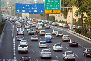
Ayalon Highway
Encyclopedia
Gush Dan
The Tel Aviv Metropolitan Area , or Gush Dan , is a metropolitan area including areas from both the Tel Aviv and the Central Districts of Israel. The area is closely linked to the city of Tel Aviv through social, economic, and cultural ties. It is located along the Israeli Mediterranean coastline...
, Israel
Israel
The State of Israel is a parliamentary republic located in the Middle East, along the eastern shore of the Mediterranean Sea...
. The road runs along Tel Aviv
Tel Aviv
Tel Aviv , officially Tel Aviv-Yafo , is the second most populous city in Israel, with a population of 404,400 on a land area of . The city is located on the Israeli Mediterranean coastline in west-central Israel. It is the largest and most populous city in the metropolitan area of Gush Dan, with...
's center eastern border from north to south (with a planned east-west branch as well) and connects all of the major highways leading to the city - such as Highway 4
Highway 4 (Israel)
Highway 4 is an Israeli highway that runs along Israel's entire coastal plain of the Mediterranean Sea, its route in the north runs from the Rosh HaNikra border crossing with Lebanon until the Erez Border Crossing with the Gaza Strip...
from Ashdod and the Southern regions
South District (Israel)
The Southern District is one of Israel's six administrative districts, and is the largest in terms of land area as well as the most sparsely populated. It covers most of the Negev desert, as well as the Arabah valley. The population of the Southern District is 1,002,400. It is 86% Jewish and 14%...
, Highway 2
Highway 2 (Israel)
Highway 2 is an Israeli highway located on the coastal plain of the Mediterranean Sea. It stretches from Tel Aviv to Haifa. The highway is also called The Coastal Highway or The New Haifa - Tel Aviv Highway ....
from Haifa
Haifa
Haifa is the largest city in northern Israel, and the third-largest city in the country, with a population of over 268,000. Another 300,000 people live in towns directly adjacent to the city including the cities of the Krayot, as well as, Tirat Carmel, Daliyat al-Karmel and Nesher...
and the Northern regions
North District (Israel)
The Northern District is one of Israel's six administrative districts. The Northern District has a land area of 4,478 km², which increases to 4,638 km² when both land and water are included...
, Highway 5
Highway 5 (Israel)
Highway 5, or the Trans-Samaria Highway , is one of Israel's main highways, connecting the Mediterranean coast immediately north of Tel Aviv with the central Sharon plain and eastwards to Ariel and other Israeli settlements in the northern West Bank, known under the biblical name Samaria.The name...
from the East, and Highway 1
Highway 1 (Israel)
Highway 1 , is the main highway connecting Tel Aviv with Jerusalem.-History:The section between Latrun and Jerusalem roughly follows an ancient path connecting Jaffa and Jerusalem...
from Jerusalem and the Southeast
Jerusalem District
The Jerusalem District is one of six administrative districts of Israel. The district capital is Jerusalem. The Jerusalem District has a land area of 652 km². The population of 910,300 is 67.8% Jewish and 30.6% Arab...
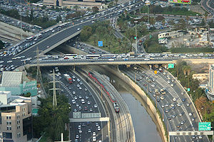
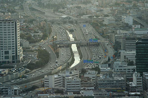
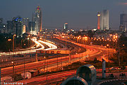
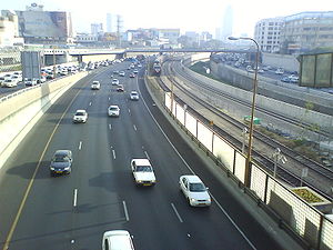
. The Ayalon Highway is heavily travelled and on an average day almost 600,000 vehicles enter the freeway. It consists of a multi-lane highway with a multi-track railway located between the opposite travel lanes. Some of the highway's route is along the Ayalon River
Ayalon River
The Ayalon River is a perennial stream in Israel, originating in the Judean Hills and mouthing into the Yarqon River in the Tel Aviv area.The total length of Ayalon River is about 50 kilometres and it drains an area of 815 square kilometres...
, hence its name.
Background
Before the construction of the Ayalon Highway, all the major inter-city highways leading to Tel Aviv terminated in the outskirts of the city. This created major traffic congestion in the entry and exit points and made driving through the city very difficult. Moreover, before the highway, Tel Aviv had two separate railway stations, one in the north and one in the south, which were not connected. Thus passengers wanting to travel to the South of the country could only do so from the southern stationTel Aviv South Railway Station
Tel Aviv South Railway Station is a former railway station in Tel Aviv, Israel, that was situated in two different locations. It opened in its first location in 1920, then relocated in 1970 and finally closed to passengers in 1993.-Original location:...
and those who wanted to travel to the North could only do so from the northern (Central) station. Even worse, trains from the northern part of the country could not travel to the southern part of the country without bypassing Tel Aviv from the East, making train travel in Israel very inefficient. Finally there was the problem of the Ayalon River, which went through parts of Tel Aviv and would sometimes cause flooding.
To solve these problems, as early as the 1950s ideas were raised regarding using the route of the river as a transportation corridor, but it wasn't until the mid-1960s that the government began planning. In the 1970s a government-owned company, Ayalon Highways Ltd., was set up to construct the highway. The first phase included construction of a concrete channel for the Ayalon River to alleviate the flooding problem. In 1982, the first section of the road opened, and in 1991 the final section of the central part of the road was completed. This section connects Route 1 in the south with Route 5 and Route 2 in the north. A railway with four stations was built in the center of the highway, which provided for the long-sought connection of Israel's railway network through Tel Aviv.
In the early 1990s the construction of a southern section of the highway had started. This section goes from the HaHagana railway station through the southern Tel Aviv suburbs of Holon, Bat Yam and Rishon LeZion and connects to Highway 4 north of Yavne
Yavne
Yavne is a city in the Central District of Israel. According to the Israel Central Bureau of Statistics , at the end of 2009 the city had a population of 33,000.-History:...
. After the highway splits with the Ayalon River at Highway 1, it goes on the route of a road called Heyl HaShiryon Road (דרך חיל השריון, "The Armored Corps Road"), then on the route of Yigael Yadin
Yigael Yadin
Yigael Yadin on 21 March 1917, died 28 June 1984) was an Israeli archeologist, politician, and the second Chief of Staff of the Israel Defense Forces.-Early life and military career:...
Road until Wolfson Interchange, where it goes on the route of Yigal Allon
Yigal Allon
Yigal Allon was an Israeli politician, a commander of the Palmach, and a general in the IDF. He served as one of the leaders of Ahdut HaAvoda party and the Israeli Labor party, and acting Prime Minister of Israel, and was a member of the Knesset and government minister from the 10th through the...
Road (דרך יגאל אלון).
The road's impact
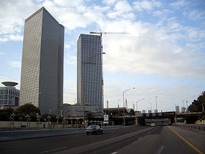
The road and railway had a major impact on the Tel Aviv region. While quite congested at times it nevertheless alleviated traveling to and through Tel Aviv. Considerable real estateReal estate
In general use, esp. North American, 'real estate' is taken to mean "Property consisting of land and the buildings on it, along with its natural resources such as crops, minerals, or water; immovable property of this nature; an interest vested in this; an item of real property; buildings or...
development of offices, shopping, and housing occurred along the route, so much so, that Tel Aviv's Central Business District
Central business district
A central business district is the commercial and often geographic heart of a city. In North America this part of a city is commonly referred to as "downtown" or "city center"...
lost much of its importance as many businesses relocated to near the road. Israel Railways
Israel Railways
Israel Railways is the principal passenger railway operating company in Israel, and is responsible for all inter-city and suburban rail way passenger and freight traffic in the country. All its lines are standard gauge. The network is centered in Israel's densely populated coastal plain, from...
saw huge increases in passenger numbers now that north/south trains could travel through Tel Aviv instead of around it.
Future plans
Currently heavy construction activity is taking place in the southern part of the highway (i.e., the section passing through the Holon, Bat Yam and Rishon LeZion suburbs) which will be completed by 2012. This involves adding more lanes, completing the construction of a second overpass in the Holon interchange and placing railroad tracks and stations in the median of the highway (as part of a project which will eventually extend the Coastal RailwayCoastal railway line, Israel
The Coastal railway line is a mainline railway in Israel, which begins just south of the Lebanon-Israel border on the Mediterranean coast, near the town of Nahariya in Northern Israel and currently ends in Tel Aviv; by 2013 it will be linked to the existing Ashdod Railway Station south of Tel Aviv,...
all the way to Ashdod). An east-west branch "Ayalon East", from Highway 5 to the Tel Aviv University
Tel Aviv University
Tel Aviv University is a public university located in Ramat Aviv, Tel Aviv, Israel. With nearly 30,000 students, TAU is Israel's largest university.-History:...
railway station along the path of the Yarkon River has been planned, but is still not approved. Currently the northern terminus of the road is in Herzliya
Herzliya
Herzliya is a city in the central coast of Israel, at the western part of the Tel Aviv District. It has a population of 87,000 residents. Named after Theodor Herzl, the founder of modern Zionism, Herzliya covers an area of 26 km²...
, but is expected to be extended further north to near kibbutz
Kibbutz
A kibbutz is a collective community in Israel that was traditionally based on agriculture. Today, farming has been partly supplanted by other economic branches, including industrial plants and high-tech enterprises. Kibbutzim began as utopian communities, a combination of socialism and Zionism...
Shefayim
Shefayim
Shefayim is a kibbutz in central Israel. Located 17 km north of Tel Aviv along the Mediterranean coast, it falls under the jurisdiction of Hof HaSharon Regional Council...
by 2016 as part of the Route 531
Route 531 (Israel)
Route 531 , is a suburban freeway in the southern Sharon region of Israel, just north of the Tel Aviv Metropolitan Area.-Herzliya–Ra'anana extension:...
construction project.
The central section of the road is built along the banks of the Ayalon River. However, Israel railways is in desperate need of adding a fourth railroad track in that area and no space exists to do so but "on top" of the river itself. Several suggestions have been made to solve this problem, ranging from diverting the entire river through Jaffa
Jaffa
Jaffa is an ancient port city believed to be one of the oldest in the world. Jaffa was incorporated with Tel Aviv creating the city of Tel Aviv-Yafo, Israel. Jaffa is famous for its association with the biblical story of the prophet Jonah.-Etymology:...
, to building an elevated highway, to creating a man-made lake for capturing flooding overflow south of the city and burying the river in a large diameter pipe and constructing the railway on top of it. All these solutions involve great cost and no decision has been made yet on how to proceed.
The long-term projection is for Route 20 to run as far north as Hadera
Hadera
Hadera is a city located in the Haifa District of Israel approximately from the major cities of Tel Aviv and Haifa. The city is located along of the Israeli Mediterranean Coastal Plain...
. However, this has garnered very strong opposition from environmental groups, since the road would have to cross a nature preserve and other sensitive environmental areas. These groups suggest widening Highway 2
Highway 2 (Israel)
Highway 2 is an Israeli highway located on the coastal plain of the Mediterranean Sea. It stretches from Tel Aviv to Haifa. The highway is also called The Coastal Highway or The New Haifa - Tel Aviv Highway ....
(the so-called "Coastal Highway"), an existing freeway north of Tel Aviv which roughly parallels (several kilometers to the west) Route 20's future route, instead of extending Route 20 northwards.
There is an effort to create a system of bus priority
Bus priority
Bus priority or transit signal priority is a name for various techniques to speed up bus public transport services at intersections with traffic signals amongst other methods. Trams and light rail vehicles can also be given priority...
for certain lines that are heavily used and that run through congested areas. This effort is being led by transportation professionals and environmental groups, such as Transport Today and Tomorrow, which seeks to improve sustainable transportation in Israel. Buses are currently subject to the same traffic as cars and creating specific lanes and other forms of prioritization would help to alleviate this problem.
Interchanges
| km | Name | Type | Meaning | Location | Road(s) Crossed |
|---|---|---|---|---|---|
| 0 | מחלף חולות (Holot Interchange) |
 |
Sand Dunes | Gan Sorek Gan Sorek Gan Sorek is a moshav in central Israel. Located in the coastal plain around four kilometres south-west of Rishon LeZion and covering 700 dunams, it falls under the jurisdiction of Gan Raveh Regional Council... |
 (Highway 4 Highway 4 (Israel) Highway 4 is an Israeli highway that runs along Israel's entire coastal plain of the Mediterranean Sea, its route in the north runs from the Rosh HaNikra border crossing with Lebanon until the Erez Border Crossing with the Gaza Strip... ) |
| 1 | מחלף מבוא איילון (Mevo Ayalon Interchange) |
|
Ayalon Ayalon Ayalon is the name of a location in Israel and a Hebrew family name. It is the modern transliteration of Ajalon. It may refer to the following:-Places:*Ajalon, a valley and Biblical town in Israel*Ayalon Cave, a cave near Ramla, Israel... Gateway |
Rishon LeZion |  (Route 431 Route 431 (Israel) Route 431 , is a suburban freeway in the south of the Tel Aviv Metropolitan Area in Israel. The freeway connects the Ayalon Highway in the west with Highway 1 in the east. It then continues east into Modi'in as a local road.... ) |
| 3.5 | מחלף משה דיין (Moshe Dayan Interchange) |
 |
Named after Moshe Dayan Moshe Dayan Moshe Dayan was an Israeli military leader and politician. The fourth Chief of Staff of the Israel Defense Forces , he became a fighting symbol to the world of the new State of Israel... |
Rishon LeZion |  (Route 441) |
| 5 | מחלף קוממיות (Komemiyut Interchange) |
|
Named after intersecting street | Bat Yam, Holon | HaKomemiyut St. |
| 6.5 | מחלף יוספטל (Yoseftal Interchange) |
|
Named after intersecting street | Bat Yam, Holon | Yoseftal Giora Yoseftal Dr Giora Yoseftal was an Israeli politician who held several ministerial portfolios in the late 1950s and early 1960s.-Biography:Born in Nuremberg in Germany, Yoseftal was a member of the Yiddisher Yudenbund youth movement in his teens... Blvd. |
| 7.5 | מחלף דב הוז (Dov Hoz Interchange) |
|
Named after intersecting street | Holon, Bat Yam | Dov Hoz Dov Hoz Dov Hoz was a leader of the Labor Zionism movement, one of the founders of the Haganah organization, and a pioneer of Israeli aviation.-Biography:... Blvd. |
| 9 | מחלף וולפסון (Wolfson Interchange) |
|
Named after nearby Wolfson Medical Center Wolfson Medical Center Wolfson Medical Center is a hospital in Holon, Israel.Wolfson Hospital is located in southern Tel Aviv Metropolitan Area, Tel Aviv district of Israel in a vicinity abounded by a population of nearly half a million inhabitants... |
Holon, Tel Aviv Tel Aviv Tel Aviv , officially Tel Aviv-Yafo , is the second most populous city in Israel, with a population of 404,400 on a land area of . The city is located on the Israeli Mediterranean coastline in west-central Israel. It is the largest and most populous city in the metropolitan area of Gush Dan, with... |
Local Roads |
| 12 | מחלף חולון (Holon Interchange) |
|
Named after location | Holon |  (Highway 44 Highway 44 (Israel) Highway 44 is a highway in central Israel. It connects Tel Aviv-Yafo to Ramla, Lod and the Shefela. It begins in Tel Aviv in the north and ends at Nachshon and Shimshon junction near Beit Shemesh in the south.... ) Levi Eshkol Levi Eshkol ' served as the third Prime Minister of Israel from 1963 until his death from a heart attack in 1969. He was the first Israeli Prime Minister to die in office.-Biography:... Blvd. |
| 13 | מחלף חיל השריון (Hel HaShiryon) |
|
Named after intersecting street | Tel Aviv Tel Aviv Tel Aviv , officially Tel Aviv-Yafo , is the second most populous city in Israel, with a population of 404,400 on a land area of . The city is located on the Israeli Mediterranean coastline in west-central Israel. It is the largest and most populous city in the metropolitan area of Gush Dan, with... |
 (Highway 2 Highway 2 (Israel) Highway 2 is an Israeli highway located on the coastal plain of the Mediterranean Sea. It stretches from Tel Aviv to Haifa. The highway is also called The Coastal Highway or The New Haifa - Tel Aviv Highway .... ) Hel HaShiryon Blvd. |
| 13 | מחלף קיבוץ גלויות (Kibbutz Galuyot Interchange) |
|
Named after intersecting street |
Tel Aviv Tel Aviv Tel Aviv , officially Tel Aviv-Yafo , is the second most populous city in Israel, with a population of 404,400 on a land area of . The city is located on the Israeli Mediterranean coastline in west-central Israel. It is the largest and most populous city in the metropolitan area of Gush Dan, with... |
  (Highway 1 Highway 1 (Israel) Highway 1 , is the main highway connecting Tel Aviv with Jerusalem.-History:The section between Latrun and Jerusalem roughly follows an ancient path connecting Jaffa and Jerusalem... /Highway 2 Highway 2 (Israel) Highway 2 is an Israeli highway located on the coastal plain of the Mediterranean Sea. It stretches from Tel Aviv to Haifa. The highway is also called The Coastal Highway or The New Haifa - Tel Aviv Highway .... /Route 461) Ingathering of the Exiles Gathering of Israel The Gathering of Israel is the promise given by Moses, in the Hebrew Bible, to the People of Israel before his death, prior to their entrance to Eretz Israel... St. |
| 14 | מחלף לה גוורדייה (LaGuardia Interchange) |
|
Named after intersecting street | Tel Aviv Tel Aviv Tel Aviv , officially Tel Aviv-Yafo , is the second most populous city in Israel, with a population of 404,400 on a land area of . The city is located on the Israeli Mediterranean coastline in west-central Israel. It is the largest and most populous city in the metropolitan area of Gush Dan, with... |
LaGuardia Fiorello H. LaGuardia Fiorello Henry LaGuardia was Mayor of New York for three terms from 1934 to 1945 as a liberal Republican. Previously he was elected to Congress in 1916 and 1918, and again from 1922 through 1930. Irascible, energetic and charismatic, he craved publicity and is acclaimed as one of the three or... St. |
| 16 | מחלף השלום (HaShalom Interchange) |
|
Named after intersecting street | Tel Aviv Tel Aviv Tel Aviv , officially Tel Aviv-Yafo , is the second most populous city in Israel, with a population of 404,400 on a land area of . The city is located on the Israeli Mediterranean coastline in west-central Israel. It is the largest and most populous city in the metropolitan area of Gush Dan, with... |
HaShalom Shalom Shalom is a Hebrew word meaning peace, completeness, and welfare and can be used idiomatically to mean both hello and goodbye... Road |
| 17 | מחלף ארלוזורוב (Arlozorov Interchange) |
|
Named after intersecting street | Tel Aviv Tel Aviv Tel Aviv , officially Tel Aviv-Yafo , is the second most populous city in Israel, with a population of 404,400 on a land area of . The city is located on the Israeli Mediterranean coastline in west-central Israel. It is the largest and most populous city in the metropolitan area of Gush Dan, with... |
Arlozorov Road  (Route 481) |
| 17.5 | מחלף ההלכה (HaHalakha Interchange) |
|
The Halakha Halakha Halakha — also transliterated Halocho , or Halacha — is the collective body of Jewish law, including biblical law and later talmudic and rabbinic law, as well as customs and traditions.Judaism classically draws no distinction in its laws between religious and ostensibly non-religious life; Jewish... |
Tel Aviv Tel Aviv Tel Aviv , officially Tel Aviv-Yafo , is the second most populous city in Israel, with a population of 404,400 on a land area of . The city is located on the Israeli Mediterranean coastline in west-central Israel. It is the largest and most populous city in the metropolitan area of Gush Dan, with... |
HaRav Rabbi In Judaism, a rabbi is a teacher of Torah. This title derives from the Hebrew word רבי , meaning "My Master" , which is the way a student would address a master of Torah... Shlomo Goren Shlomo Goren Shlomo Goren , was an Orthodox Religious Zionist rabbi in Israel who founded and served as the first head of the Military Rabbinate of the Israel Defense Forces and subsequently as the third Ashkenazi Chief Rabbi of Israel from 1973 to 1983.He served in the Israel Defense Forces during three wars,... St. |
| 19 | מחלף רוקח (Rokah Interchange) |
|
Named after intersecting street | Tel Aviv Tel Aviv Tel Aviv , officially Tel Aviv-Yafo , is the second most populous city in Israel, with a population of 404,400 on a land area of . The city is located on the Israeli Mediterranean coastline in west-central Israel. It is the largest and most populous city in the metropolitan area of Gush Dan, with... |
Rokah Israel Rokach Israel Rokach, Honorary CBE was an Israeli politician, Knesset member, and mayor of Tel Aviv from November 15, 1936 to April 13, 1953.-Biography:... Blvd. |
| 21 | מחלף קרן קיימת (Keren Kayemet Interchange) |
|
Named after intersecting street | Tel Aviv Tel Aviv Tel Aviv , officially Tel Aviv-Yafo , is the second most populous city in Israel, with a population of 404,400 on a land area of . The city is located on the Israeli Mediterranean coastline in west-central Israel. It is the largest and most populous city in the metropolitan area of Gush Dan, with... |
Keren Kayemet LeYisrael (JNF) Jewish National Fund The Jewish National Fund was founded in 1901 to buy and develop land in Ottoman Palestine for Jewish settlement. The JNF is a quasi-governmental, non-profit organisation... Blvd. |
| 23 | מחלף גלילות מזרח (Glilot Mizrah Interchange) |
|
Named after location of former Jewish refugee camp Ma'abarot The Ma'abarot were refugee absorption camps in Israel in the 1950s. The Ma'abarot were meant to provide accommodation for the large influx of Jewish refugees and new Olim arriving to the newly independent State of Israel, replacing the less habitable immigrant camps or tent cities... East Glilot |
Ramat HaSharon Ramat Hasharon Ramat HaSharon is a city located on Israel's central coastal strip in the south of the Sharon region, bordering Tel Aviv to the south and Herzliya and Kibbutz Glil Yam to the north. It is part of the Tel Aviv District, within Gush Dan metropolitan area... |
  (Highway 5 Highway 5 (Israel) Highway 5, or the Trans-Samaria Highway , is one of Israel's main highways, connecting the Mediterranean coast immediately north of Tel Aviv with the central Sharon plain and eastwards to Ariel and other Israeli settlements in the northern West Bank, known under the biblical name Samaria.The name... to Highway 2 Highway 2 (Israel) Highway 2 is an Israeli highway located on the coastal plain of the Mediterranean Sea. It stretches from Tel Aviv to Haifa. The highway is also called The Coastal Highway or The New Haifa - Tel Aviv Highway .... ) |
| 25.5 | מחלף שבעת הכוכבים (Shiv'at HaKohavim Interchange) |
|
The Seven Stars (Hertzl's Zionist flag design) |
Herzliya Herzliya Herzliya is a city in the central coast of Israel, at the western part of the Tel Aviv District. It has a population of 87,000 residents. Named after Theodor Herzl, the founder of modern Zionism, Herzliya covers an area of 26 km²... |
 (Route 541) |
| 27.5 | מחלף המעפילים (HaMa'apilim Interchange) |
 |
The Clandestine Immigration | Kfar Shmaryahu Kfar Shmaryahu Kfar Shmaryahu is a local council in Israel, within the Tel Aviv District. The council was founded in 1937, during the Fifth Aliyah to Israel.Kfar Shmaryahu is ranked very highly on the Israeli socio-economic scale... Northbound only |
(Route 541) |
| In planning stages | |||||
| 29 |  מחלף רשפון מחלף רשפון(Rishpon Interchange) |
|
Named after nearby moshav Moshav Moshav is a type of Israeli town or settlement, in particular a type of cooperative agricultural community of individual farms pioneered by the Labour Zionists during the second aliyah... |
Rishpon Rishpon Rishpon is a moshav in the Center District of Israel. Located in the Sharon plain near Herzliya, it falls under the jurisdiction of Hof HaSharon Regional Council. In 2007 it had a population of 1,000.... |
 (Route 531 Route 531 (Israel) Route 531 , is a suburban freeway in the southern Sharon region of Israel, just north of the Tel Aviv Metropolitan Area.-Herzliya–Ra'anana extension:... /Highway 2) |
Northbound Ayalon continues on to its current terminus at Menachem Begin
Menachem Begin
' was a politician, founder of Likud and the sixth Prime Minister of the State of Israel. Before independence, he was the leader of the Zionist militant group Irgun, the Revisionist breakaway from the larger Jewish paramilitary organization Haganah. He proclaimed a revolt, on 1 February 1944,...
St. in Herzliya
Herzliya
Herzliya is a city in the central coast of Israel, at the western part of the Tel Aviv District. It has a population of 87,000 residents. Named after Theodor Herzl, the founder of modern Zionism, Herzliya covers an area of 26 km²...
.
Railway stations
Train station
A train station, also called a railroad station or railway station and often shortened to just station,"Station" is commonly understood to mean "train station" unless otherwise qualified. This is evident from dictionary entries e.g...
are located nearby the following interchanges (with station name in parenthesis, if differs from interchange name): Rokach (University), Arlozorov (Central), HaShalom, Kibbutz Galuyot (HaHagana), Holon (Holon Junction), Wolfson, Yoseftal, Komemiyut, Moshe Dayan.
External links
Ayalon Highways Ltd. - Official site. Includes up to the minute traffic reports and live traffic camera views.- http://www.transportation.org.il/ Transport Today and Tomorrow